72
Peak V. Orlova via the E buttress and E ridge, Pamiro-Alai 5.1.1.
Passport
- Category
- Pamiro-Alai, Alai Ridge, Archakanysh gorge.
- Peak V. Orlova, via the E buttress and SE ridge.
- Proposed — cat. 3A difficulty, first ascent.
- Height difference: 430 m, wall section — 170 m.
- Route length: 760 m. Average slope 45°
- Pitons hammered: rock protection — 16 + 1 wedge.
- Team's travel time: 6 hours.
- Leader: Orlov V.G. — CMS.
Team members:
- Krivitskiy A.N. — 1st sports category.
- Yurish S.Yu. — 1st sports category.
- Samoilov L.A. — 1st sports category.
- Lazarev V.V. — 1st sports category.
- Aleksandrova A.D. — 1st sports category.
- Team coach: Orlov V.G. — CMS.
- Approach to the route, summit, and descent: July 9, 1992.
- Organized by Lviv Regional Alpine Club "Skelya".
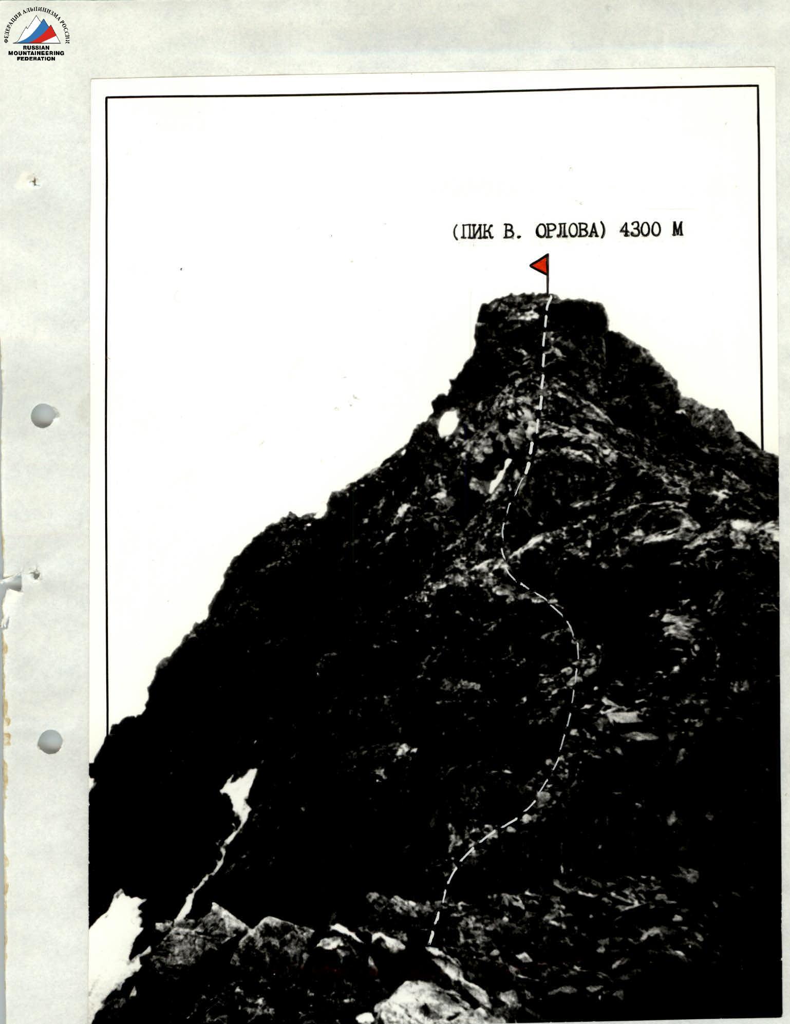
 F1. Photo taken on July 10, 1992, 6:00, lens "Yupiter-8M" F=2/50 mm, 6 km, 3850 m.

F2. Photo taken on July 9, 1992, lens "Minitar", F=32 mm. Section R6–R7.
Brief overview of the ascent area
The approach to Peak V. Orlova from the base camp in the poplar grove through the Surmetash and Archakanysh gorges takes 6–8 hours, depending on the group's load and physical fitness. The object of the ascent is located in the right part of the cirque, crowned with peaks such as:
- Peak Leningradets — 4980 m,
- Peak Moskvich — 4600 m,
- Paltsy — 4500 m.
The Eastern wall is a series of buttresses separated by couloirs descending from the SE ridge to the base of the wall. The edge is composed of marble rocks, mostly destroyed, requiring special attention and caution when passing through.
The E buttress logically leads to the pre-summit ridge. Bypassing the buttress through the couloirs is dangerous due to rockfall.
From the summit, a magnificent panorama of all routes on Peaks Leningradets, Moskvich, and Paltsy opens up.
The route can be recommended for training ascents for sports groups.
Brief description of the ascent route
From the initial bivouac, located at the confluence of the Archakanysh River and the stream originating from the Dugoba Glacier, 1–1.5 km downstream along the Archakanysh River.
Cross to the right bank of the Archakanysh River. Then, follow the trail uphill. At the beginning of the ascent, there are good platforms for overnight stays. From the bivouac, it takes 1–1.5 hours.
In the cirque, turn right and approach the Eastern wall. R0–R1 — a snowy slope with moraine outcrops. The route begins at the base of a large triangular gendarme, to the right of which is a small waterfall, and to the left — a couloir.
R1–R2 — a wall located to the left of the triangular gendarme. It is possible to pass through the left part of the internal angle to the left of the gendarme. Insurance is alternating, through ledges. At the end of the section, there is a small platform.
R2–R3 — a system of walls and small ledges. The rock is fragile. Requires attention. Climbing is above average difficulty. Piton protection.
R3–R4 — a steep wall. The key section of the route. Free climbing, above average difficulty. Piton protection. On the ledge — a control cairn.
R4–R5 — continuation of the wall. Climbing is of average difficulty. Many loose rocks. Piton placement is limited.
R5–R6 — broken rocks. Insurance is alternating, through ledges. The section leads to a saddle between Peak Moskvich and Peak V. Orlova. On the saddle, turn right.
R6–R7 — a broken ridge. Simultaneous movement. Insurance through ledges.
R7–R8 — continuation of the pre-summit ridge, composed of large blocks. Small gendarmes are passed head-on. Simultaneous movement, insurance through ledges.
Descent from Peak V. Orlova down the SE ridge to the saddle between Peaks Moskvich and V. Orlova. Then, turn right and descend via scree into the adjacent cirque.