Ascent Passport
I. Technical Class.
2. Pamir-Alai, horseshoe of Cosmonauts
3. Nikolaeva Peak, height 4900, ascent along the Eastern ridge
4. Proposed difficulty category — 3B cat. diff.
5. Route characteristics:
height difference — 800 m
length of the section:
5 cat. diff. — 8 m
4 cat. diff. — 50 m
3 cat. diff. — 275 m
2 cat. diff. — 90 m
1 cat. diff. — 560 m

average steepness — 45° 6. Pitons driven: for belaying and for creating belay stations: rock — 12 ice — 4 7. Number of travel hours — 12 hours 8. Overnights — none 9. Team members: Kedrya A.Ya. — 2nd sports category Toropchin V.I. — 2nd sports category. Coach: Saprykin V.D. — Master of Sports, senior instructor 10. Date of departure and return — August 12, 1977
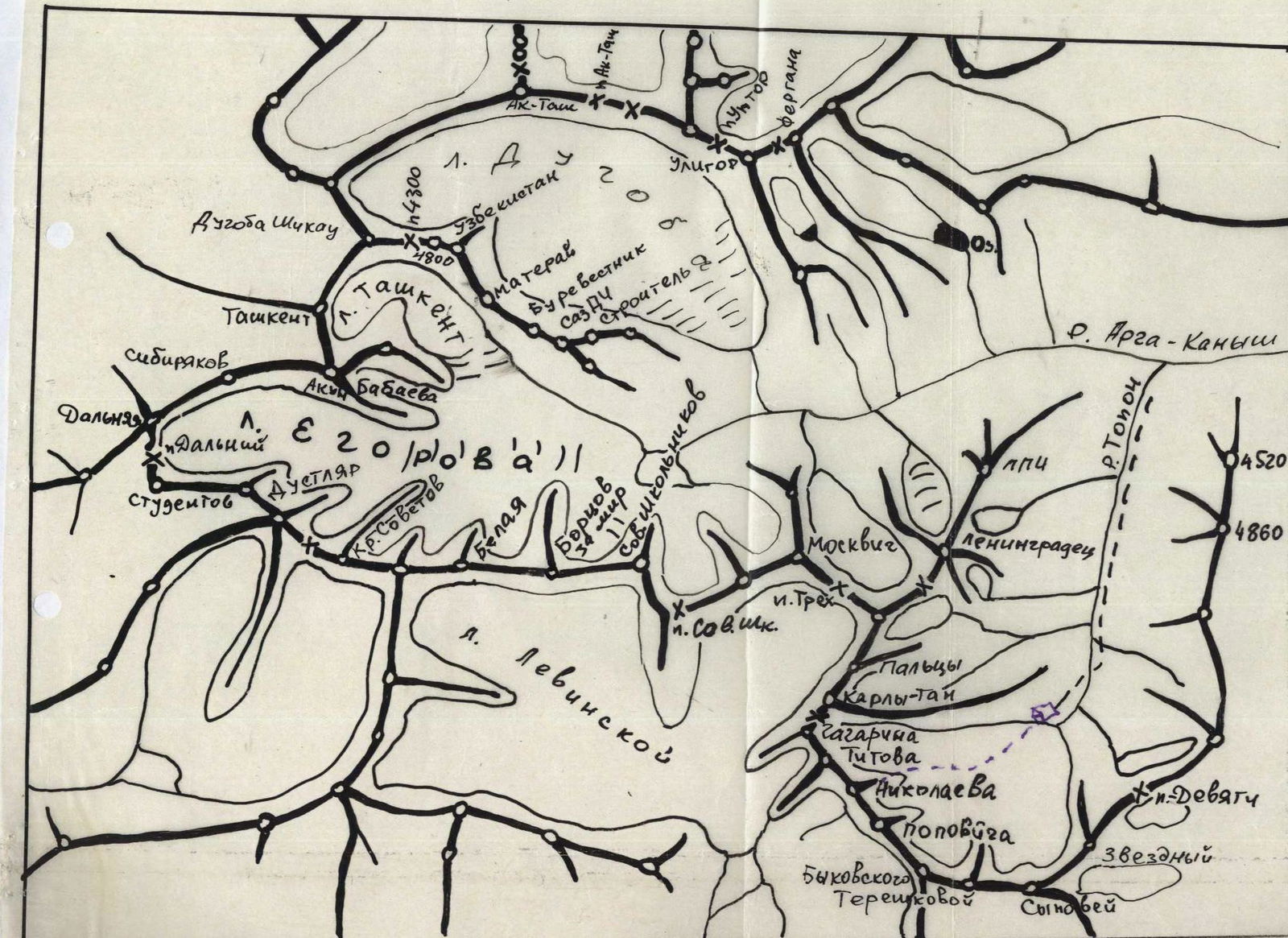
I. Brief description of the approach to the route
From the base camp in front of the "Zaval" in the Archa-Kadysh valley (base camp of the "Archa-Kanysh" branch of the "Dugoba" tourist center) it is necessary to cross the widely spread r. Archa-Kanysh to the left (in the direction of travel) side and enter the valley that goes to the left.
This valley (local name Tupon) is closed by the horseshoe of Cosmonauts.
Pass through the valley (there are trails on both sides of the river) and, 300 m before the terminal moraine of the glacier, turn right. Walk along the trail for another 20–30 minutes. The trail ends at a large green clearing near the first moraine lake. This is the overnight location.
Travel time from the base camp on the "Zaval":
- 4.5–5 hours.
Nikolaeva Peak stands out from all the peaks of the horseshoe:
- by its size — it appears higher than other peaks;
- by a clearly defined long Eastern ridge.
From the overnight location, it is necessary to go to the first moraine lake, go around it on the right along the slope and, crossing the moraine, go to the Kosmonavtov glacier. Then along the glacier approach from the left to the Eastern ridge of Nikolaeva Peak. The route begins here from the "ram's foreheads".
From the overnight location 40–50 minutes.
Alai Range, Archa-Kanysh valley
II. Brief explanation of the table (see Appendix I)
Along the central couloir of Nikolaeva Peak, through the "ram's foreheads", rocks often fall with the sunrise. Therefore, the first part of the route — to the exit to the ridge — must be completed before sunrise.
Section R0–R1. The simplest part of the route. It is passed simultaneously along the left slope of the Eastern ridge in the direction of gendarme No. 3.
Section R1–R2. On this section, gendarme No. 3 is overcome. To do this, it is necessary to go to the shoulder of the gendarme on the right along a very destroyed slope-wall, and then go around it on the left along steep smooth slabs. Climbing on this section is category 3 difficulty.
Section R2–R3. Section of the destroyed ridge. Movement is simultaneous, climbing is category 2 difficulty.
Section R3–R4. On this section, gendarme No. 4 — "wedge" is overcome (from the ridge, gendarme No. 4 is visible as a regular-shaped wedge). The gendarme is bypassed on the right along a very destroyed, almost completely filled with ice, slope. Here ice pitons are necessary. Climbing is category 3 difficulty.
Section R4–R5. This is one rope length of a simple narrow ridge. Movement is simultaneous, climbing is category 2 difficulty.
Section R5–R6. On this section, gendarme No. 5 is bypassed on the left. Here is one rope length of climbing category 3 difficulty along 1.5–2 m walls, alternating with narrow shelves. The section is very destroyed, requires maximum attention.
Section R6–R7 is a 20–25-meter very narrow sandy ridge — "knife". You can only move along it by sitting astride it. There are no places for driving pitons. Climbing is category 3 difficulty.
Section R7–R8 — this is the first ascent to gendarme No. 6 — the largest on the Eastern ridge. It is overcome from right to left upwards along an inclined inner corner. The corner is very steep, its left wall is smooth, and the right one consists of overhanging blocks. Climbing on this section is category 4 difficulty. Ice pitons are necessary.
Table of technical characteristics of the route

| 1 | 2 | 3 | 4 | 5 | 6 | 7 | 8 | 9 | 10 | 11 | 12 | 13 | 14 | 15 |
|---|---|---|---|---|---|---|---|---|---|---|---|---|---|---|
| Date | Designation | Average steepness in degrees | Length in m | Terrain characteristics | Difficulty | Condition | Weather conditions | Rock | Ice | Bolt | Rock | Ice | Bolt | Time of departure and stop for bivouac; travel hours; conditions |
| 12.08 | R0–R1 | 45° | 300 | ram's foreheads, scree | 1 | rockfall | clear | ledges, simultaneous | ice | new | ledges, simultaneous | vegetated | movement | |
| -"'- | R1–R2 | 60° | 60 | walls, smooth slabs | 3 | destroyed | -"- | - | 1 | ice | groups | free | climbing | |
| -"'- | R2–R3 | 30° | 50 | ridge | 2 | destroyed | -"- | ledges, simultaneous | ice | burdened | ice | burdened | movement | |
| -"'- | R3–R4 | 60° | 60 | slope | 3 | very destroyed, ice | -"- | 3 | ice | groups | free | climbing | ||
| -"'- | R4–R5 | 20° | 40 | narrow ridge | 2 | destroyed | -"- | ledges, simultaneous | ice | burdened | simultaneous | movement | ||
| -"'- | R5–R6 | 60° | 40 | walls, shelves | 3 | very destroyed | -"- | 2 | in-place | grouped | free | climbing alternately | ||
| -"'- | R6–R7 | 40° | 35 | sharp ridge, "knife" | 3 | smooth, sandstone | -"- | in-place | grouped | -"- | ||||
| -"'- | R7–R8 | 70° | 45 | inclined, inner corner | 4 | blocks, monolith | -"- | 2 | 1 | in-place | grouped | -"- | ||
| -"'- | R8–R9 | 60° | 30 | wall | 3 | blocks, destroyed | -"- | - | 1 | - | free | climbing alternately | ||
| -"'- | R9–R10 | 20° | 60 | simple ridge | 1 | monolith | -"- | ledges, simultaneous | simultaneous | temporary | movement | |||
| -"'- | R10–R11 | 70° | 5 | inner corner | 4 | monolith, ice | -"- | 1 | - | - | free | climbing, alternately | ||
| -"'- | R11–R12 | 80° | 8 | ridge ascent | 5 | monolith, smooth wall | -"- | 2 | - | - | -"- | |||
| -"'- | R12–R13 | 60° | 60 | ridge, walls, inner corners | 3 | monolith | -"- | 2 | 1 | - | -"- | |||
| -"'- | R13–R14 | 30° | 200 | ridge | 1 | monolith, snow-covered | -"- | ledges, simultaneous | -"- |
The group departed at 6:00, was at the summit at 14:00, descended to the bivouac at 18:00. Travel hours — 12.
NOTE: when determining the difficulty categories of sections and the difficulty category of the route as a whole, the methodology proposed in the book by A.F. Naumov "Karaugom, Digoria, Tsey" was used.
Section R8–R9. The second ascent to gendarme No. 6 — is a wall consisting of destroyed blocks. Climbing is category 3 difficulty. Ice pitons are necessary.
Section R9–R10. After gendarme No. 6, there are 60 m of a simple monolithic ridge. Movement is simultaneous, climbing is category 1 difficulty.
Section R10–R11. Section R9–R10 leads to a stone-gendarme on the ridge. It is bypassed on the right with a descent 6–7 m down. The ascent to the ridge goes along a 5-meter steep inner corner. The inner corner is completely filled with ice. It is necessary to use an ice axe and an ice piton. Climbing is category 4 difficulty.
Section R11–R12. Immediately after section R10–R11, there is a steep (80°), completely smooth, 8-meter ascent of the ridge. This monolithic, with smoothed footholds wall, is preferably overcome in rubber boots. There is one place for driving a piton. Climbing is category 5 difficulty.
Section R12–R13. On this section, gendarme No. 7 is bypassed on the left. For 60 m, there are constantly 2–3-meter walls, inner corners, steep slabs. The rocks are monolithic, climbing is category 3 difficulty.
Section R13–R14. After gendarme No. 7 to the summit, there are 200 m of a simple snow-covered ridge. Movement is simultaneous, climbing is category 1 difficulty.
From the overnight location to the summit 7.5–8 hours
Descent along the ascent route takes 4–5 hours


