Ascent Passport
-
Ascent class — technical.
-
Ascent region — Pamir-Alai.
-
Peak — MOSKVICH 4600 m via the north-northeast ridge.
-
Expected difficulty category — third. 3B.
-
Route characteristics: elevation gain — 1000 m.
average steepness — 45°.
-
Pitons driven for protection: rock — 7.
ice — 9.
-
Number of travel hours — 10.
-
Full name of the leader, participants, and their qualification:
Nezametdinov A.B. Master of Sports of the USSR, leader. Andreev V.I. 1st sports category. Kononova E.P. Candidate Master of Sports. Polishchuk V.A. 1st sports category. Chuprynin E.I. 1st sports category.
-
Date of departure and return — July 2, 1977.
 Brief map of the region.
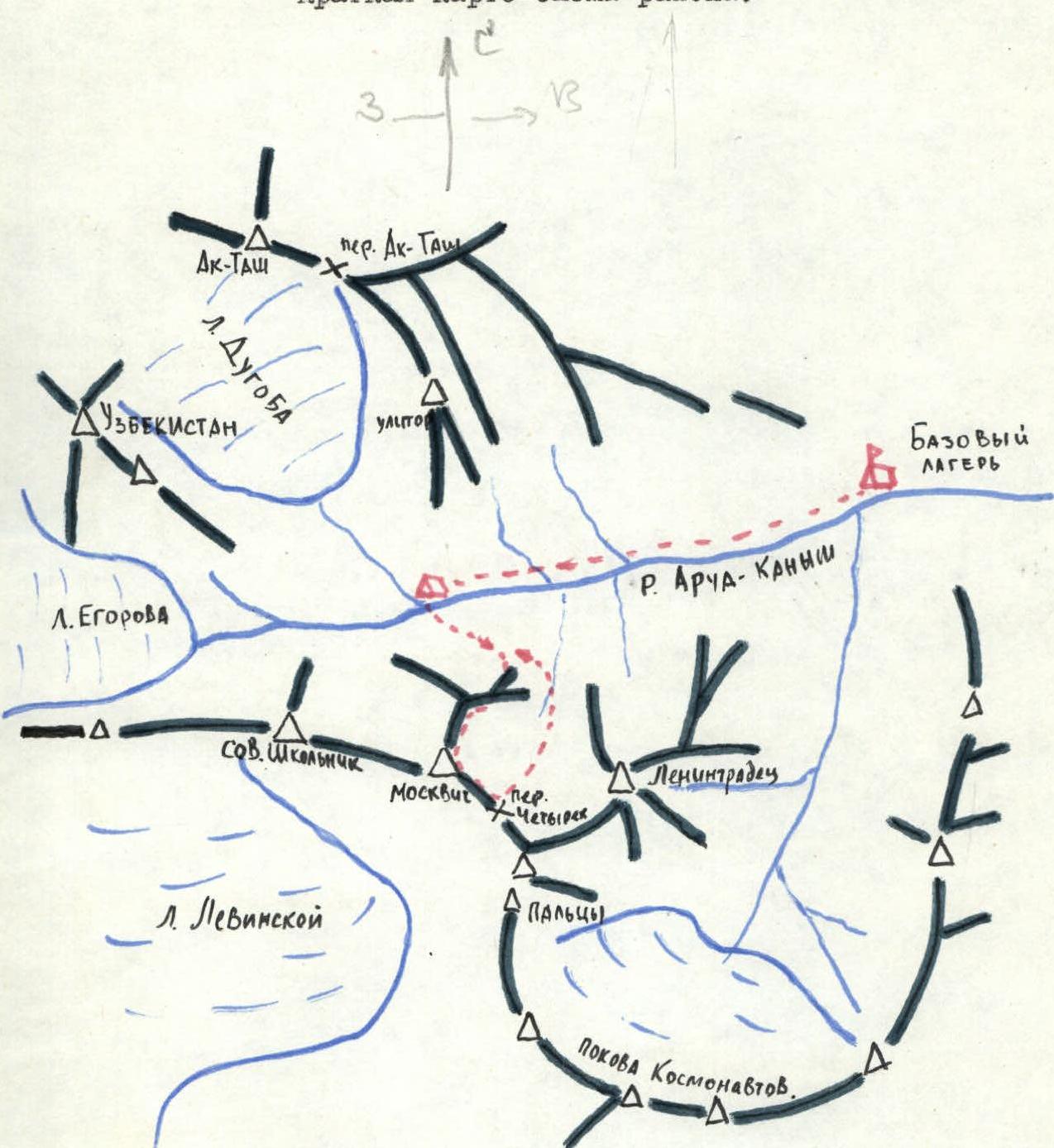
Description of the Ascent Region
Fig. 1. Peak Moskvich (4600 m) is located in the Alai Range, stretching from west to east, between the peaks Leningradets (5080 m) to the east and Soviet Shkolnik (4450 m) to the west.
The terrain is heavily dissected. Geologically, the region is young and orogenesis is not complete. Earthquakes are frequent. The rocks composing the ridges are diverse — granites, schists, gneisses, etc.
The glaciation consists of several large valley-type glaciers — Egorov Glacier and Dugoba Glacier.
The snow line is at an altitude of 3800–4000 m. The rivers are full-flowing, with rapids and steep gradients, and a fast current. The water level depends on the time of year and varies significantly throughout the day. The highest water level is observed in July–August.
The climate is characterized by low precipitation and sharp continentality. Additionally, there is a microclimate in individual valleys due to the complex orography. Overall, the region is known for good weather in July and August.
The vegetation is quite uniform. Up to altitudes of 2500–2660 m, the slopes are dominated by wormwood and saxaul. The 3200–3800 m altitude zone receives the most precipitation. Birches, poplars, rowans, and wild roses grow in the valleys.
In the valleys of the Surmetash and Archa-Kanysh rivers, juniper grows up to an altitude of 3100 m. Edelweiss is often found.
The wildlife is diverse — marmots, hares, mountain goats, and snow leopards are found here.
Among the birds, eagles, ulars, and jackdaws can be seen.
The region can be reached via two paths.
The first path goes from Fergana to the Dugoba alpine camp via the Ak-Tash pass. The journey takes several days.
The second path lies from Fergana through Uch-Kurgan by car to the fork in the road at the Golubaya Chaikhana. From here to the base camp at the talus is 30–35 km. By car, you can drive another 7–8 km along the gorge to a meadow. The meadow can accommodate a helicopter. From here to the base camp takes 6–8 hours.
Brief Description of the Approach to the Route
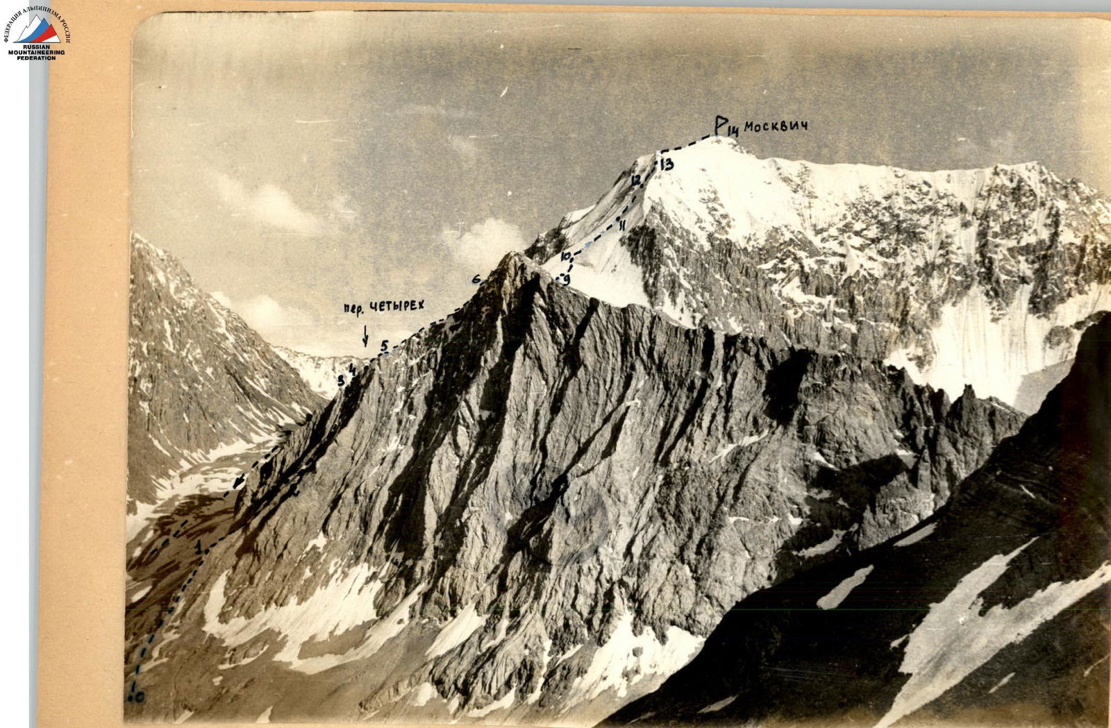
From the base camp at the talus (see the map in Fig. 1), follow the trail along the Archa-Kanysh River to its confluence with the Dugoba River. This is a convenient place to spend the night. The journey from the base camp takes 2 hours. The beginning of the route is clearly visible from here. The route starts to the right of the green cape (see Fig. 2) when viewed from the river in the direction of Peak Leningradets. The ascent is via scree and heavily destroyed rocks to the ridge.
From the camp at the confluence, it takes 30 minutes to reach the route (including crossing the Archa-Kanysh River).
Route Description
The route begins to the right of the green cape when viewed from the Archa-Kanysh River in the direction of Peak Leningradets (see Fig. 2). The ascent is via scree and then heavily destroyed rocks composed of weathered limestones to the ridge (edge). Initially, the ridge goes southwest and then curves into a southerly direction. The rocks are of medium difficulty and are destroyed. The steepness of the ridge is 40–45°, and it is very narrow in places. One can move on either side of the ridge. Protection is via outcrops and bends.
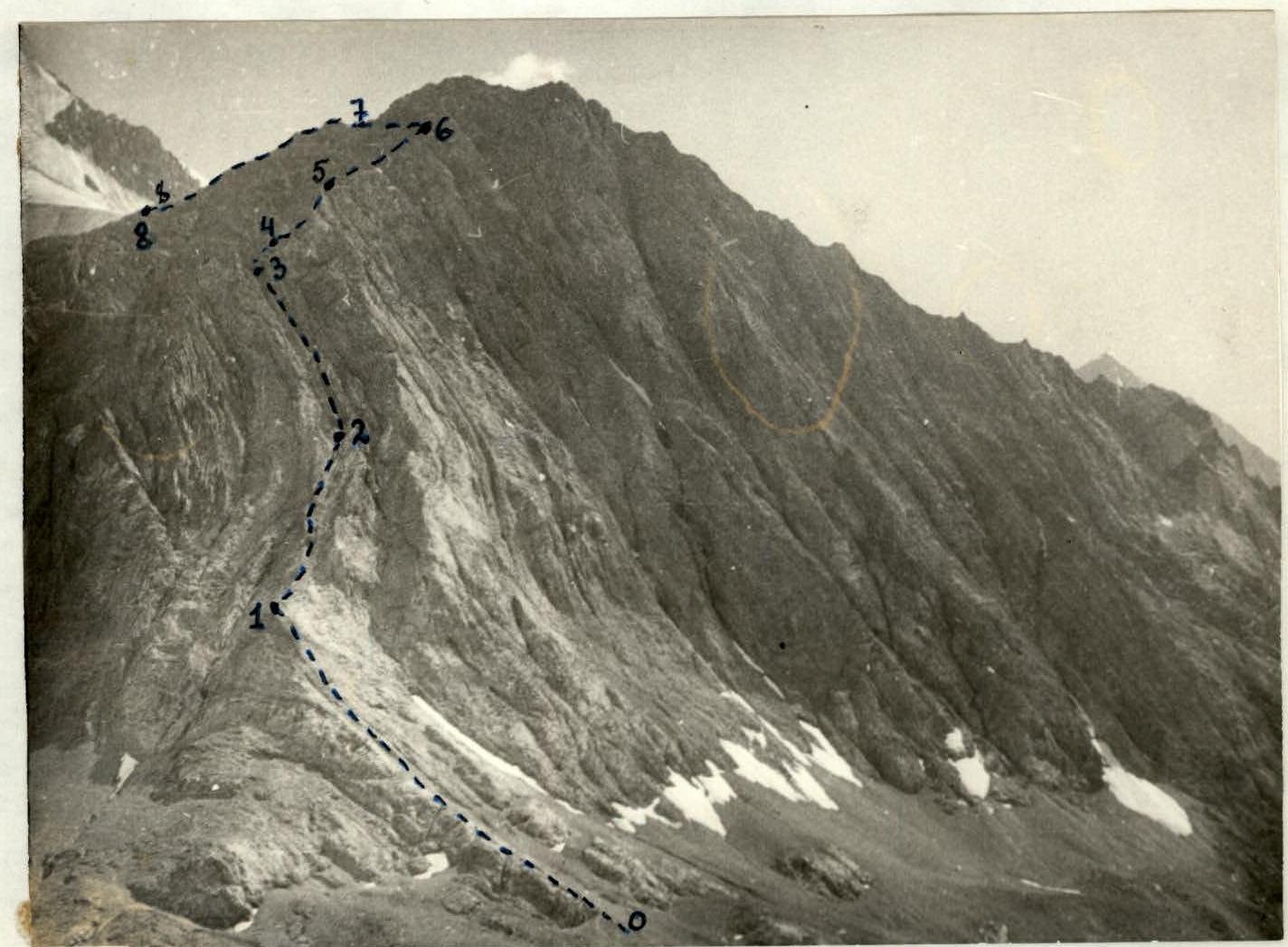
Fig. 2. Beginning of the route. We gain approximately 300 m in 1 hour 15 minutes. The ridge degenerates into a gully (section R2–R3). Move along the right edge of the gully with piton protection towards two triangular gendarmes (see Fig. 3). Approximately 5 ropes. The exit to the saddle between the gendarmes is steep. Be cautious of loose rocks.

Fig. 3. Gully and exit to the saddle between gendarmes. There is a platform between the gendarmes. This is the first control point. The exit to the right gendarme is via a 10-meter wall with a steepness of 70°. The wall is climbed diagonally from right to left with piton protection. The path then continues along the ridge, which is composed of slabs. An ledge allows for a traverse to the left of the ridge, and then back onto it. The ridge gradually becomes less steep and is composed of sharp rock "fins." Movement is simultaneous, with protection by wedging into outcrops. The length of this ridge section is approximately 10 ropes. The ridge then abuts a bastion wall.
We traverse onto a neighboring ridge in the direction of the summit via an scree ledge. Descent along a heavily destroyed ridge towards a snow plateau. The second control point is located at the end of this ridge.
The further path goes along a snow-ice slope (see Fig. 4).
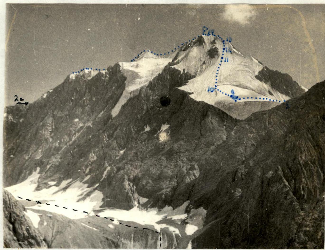
Fig. 4. View of the plateau and snow-ice slope of Peak Moskvich. We approach the bergschrund along a gentle and then increasingly steep slope, approximately 40°. The bergschrund is crossed at its narrowest left part. The slope steepness increases, and movement is with alternating protection. The exit to the pre-summit ridge is steep; the last 40 meters have a steepness of 55° (see Fig. 5). Movement along the ridge is with alternating protection. CAUTION: there are cornices on the left. After 3–4 ropes, we reach the summit.
Descent is via route 2A category of complexity in the direction of the Chëtyrëkh pass.
Table
| character | section | protection | passage of section with i.t.o. | ||||||
|---|---|---|---|---|---|---|---|---|---|
| 1 | 2 | 3 | 4 | 5 | 6 | 7 | 8 | 9 rock | 10 ice |
| 11 piton | 12 | 13 | 14 | 15 | |||||
| 2.07 | R0–R1 | 20–25 | 300 | rocks, | 1 | scree | good | - | - |
| - | simultaneous | 6:30 | |||||||
| - | R1–R2 | 35–40 | 300 | ridge | 2 | monolith | - | outcrops, bends | - |
| - | free climbing | ||||||||
| - | R2–R3 | 40–45 | 200 | gully | 3 | - | - | 4 | outcrops |
| - | free climbing | ||||||||
| - | R3–R4 | 70 | 10 | wall | 3 | - | - | 3 | - |
| - | free climbing | ||||||||
| - | R4–R5 | 35–40 | 200 | ledges, | 2 | - | - | outcrops | - |
| - | simultaneous | ||||||||
| - | R5–R6 | 30 | 200 | ridge | 2 | - | - | - | - |
| - | simultaneous | ||||||||
| - | R6–R7 | 10 | 100 | ledges | 1 | - | - | - | - |
| - | simultaneous | ||||||||
| - | R7–R8 | 0 | 150 | ridge | 1 | - | - | - | - |
| - | simultaneous | ||||||||
| - | R8–R9 | 20–25 | 200 | slope | 1 | snow | - | - | - |
| - | simultaneous | ||||||||
| - | R9–R10 | 30–35 | 80 | slope | 3 | snow, ice | - | via ice axe | - |
| - | alternating | ||||||||
| - | R10–R11 | 40 | 200 | slope | 3 | ice | - | - | 4 |
| - | alternating | ||||||||
| - | R11–R12 | 40–45 | 40 | slope | 3 | ice | - | - | 2 |
| - | alternating | ||||||||
| - | R12–R13 | 45–50 | 40 | slope | 3 | ice | - | - | 3 |
| - | alternating | ||||||||
| - | R13–R14 | 35 | 160 | ridge | 3 | snow | - | - | - |
| - | simultaneous | ||||||||
| 7 | 9 | - | travel hours | 10 h |