ASCENT PASS
- Class: rock
- Climbing area: Pamir-Alai, Alai Ridge
- Ascent route: Mashalyan peak via South face
- Difficulty category: 5B (2nd)
- Route characteristics:
- elevation gain: 1020 m
- length of sections with 5–6 difficulty category: 910 m
- average steepness: 65°
- Pitons used:
- for belay:
- rock: 44
- protection: 45
- for creating hanging belays:
- rock: 4
- protection: 3
- for belay:
- Climbing hours: 12
- Number of bivouacs and their characteristics: none
- Surname, name, patronymic of the leader and participants and their qualification:
- Pushkarev Viktor Mikhailovich, Candidate for Master of Sports — leader
- Lebedikhin Alexey Veniaminovich, Master of Sports — participant
- Vinogradsky Evgeny Mikhailovich, Master of Sports — participant
- Samoilin Valery Alekseevich, Master of Sports — participant
- Team coach: Efimov Sergey Borisovich, Master of Sports
- Departure and return dates:
- departure: July 5, 1980 at 4:30
- return: July 5, 1980 at 16:30
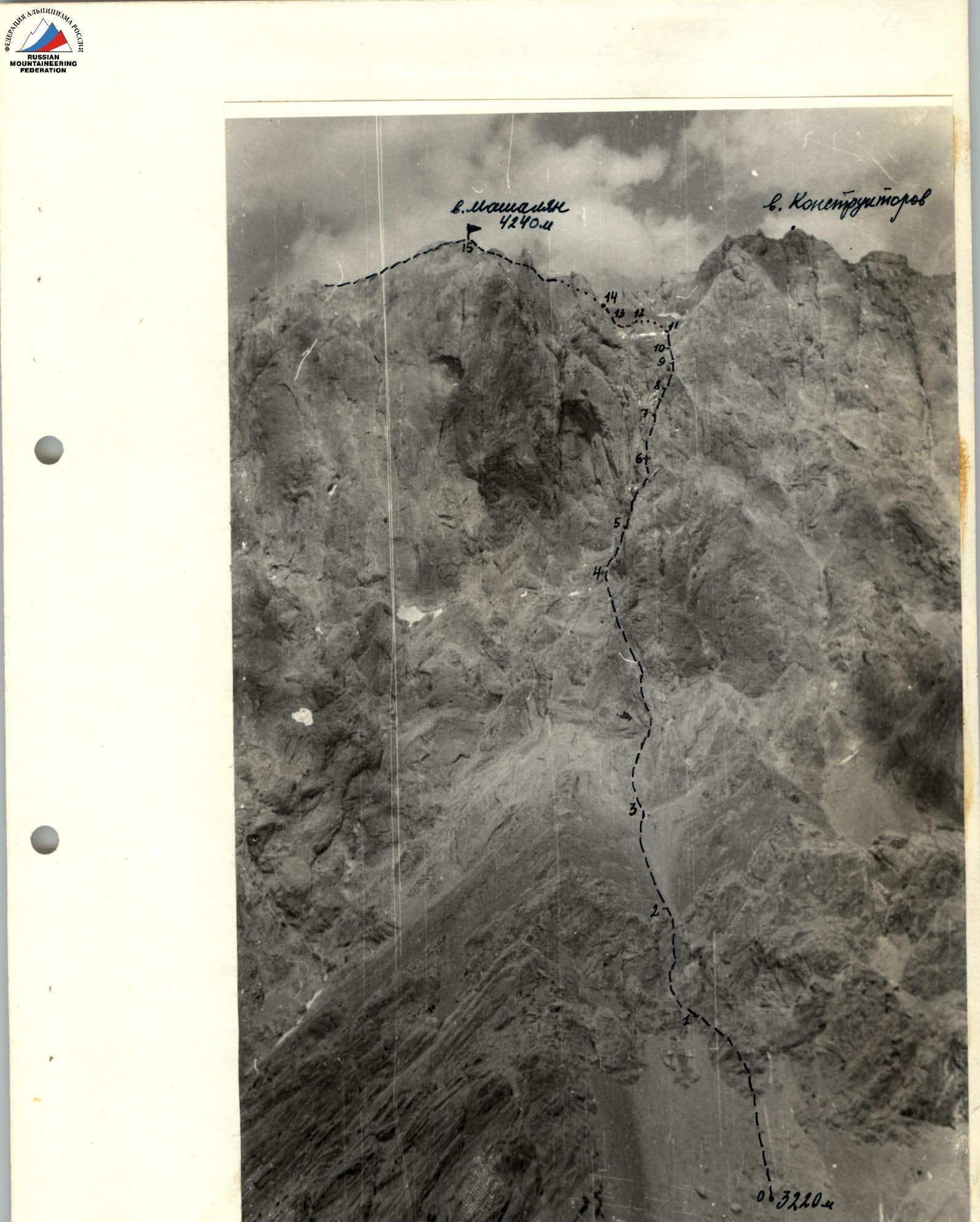
Photo 1. General view of the route.
TABLE
Main characteristics of the ascent route to Mashalyan peak via South face
Route length: 1370 m Elevation gain: 1020 m Average steepness: 65°
Start of ascent: July 5, 1980 at 4:30 Return: July 5, 1980 at 16:30
| Date | Section | Average steepness, ° | Length, m | Terrain | Difficulty category | Condition | Weather | Rock | Ice | Protection | Bolts |
|---|---|---|---|---|---|---|---|---|---|---|---|
| – | R0–R1 | 35 | 100 | slope | 1 | scree | cloudy | – | – | – | – |
| – | R1–R2 | 50 | 80 | wall | 4 | broken rocks | cloudy | 3 | – | 3 | – |
| – | R2–R3 | 30 | 80 | slope | 2 | scree, broken rocks | cloudy | – | – | – | – |
| – | R3–R4 | 60 | 200 | wall | 5 | rocky brows, wet snow | wet snow | 5 | – | 8 | – |
| – | R4–R5 | 55 | 180 | wall | 5 | monolith | cloudy | 4 | – | 9 | – |
| – | R5–R6 | 80 | 130 | wall | 5 | monolith | cloudy | 8 | – | 6 | – |
| – | R6–R7 | 90 | 60 | chimney and crack | 6 | monolith | cloudy | 5 | – | 4 | – |
| – | R7–R8 | 70 | 40 | wall | 5 | monolith | cloudy | 2 | – | 2 | – |
| – | R8–R9 | 85 | 40 | cracks and wall | 6 | monolith | cloudy | 4 | – | 3 | – |
| – | R9–R10 | 90 | 80 | chimney | 5 | monolith | cloudy | 6 | – | 4 | – |
| – | R10–R11 | 90 | 40 | wall | 6 | monolith | cloudy | 2 | – | 3 | – |
| – | R11–R12 | 85 | 90 | cracks | 5 | monolith | cloudy | 4 | – | 5 | – |
| – | R12–R13 | 70 | 50 | sharp "knife" | 5 | monolith | cloudy | 3 | – | 1 | – |
| – | R13–R14 | 50 | 80 | wall | 4 | monolith | cloudy | 3 | – | – | – |
| – | R14–R15 | – | 120 | ridge | 4 | rocky brows | cloudy | – | – | – | – |
Brief explanation of the table
R0–R1 Scree slope, not dangerous. R1–R2 Broken rocks. Up the wall for 40 m. Slightly left up the wall. "Live" rocks. R2–R3 Scree and broken rocks in sections. Simultaneous movement. R3–R4 Large, smooth slabs with small depressions and roughness. Friction climbing. Belaying is difficult. R4–R5 Wall, smooth rocks with limited holds. Piton and protection belaying. R5–R6 Smooth walls, monolithic. At the top — a chimney. R6–R7 Vertical chimney narrowing to a crack. At the top — a cornice. Further, a small wall and another cornice, which is climbed using hanging belays. R7–R8 Slightly left up the wall. Rocks are smooth with few holds. R8–R9 Vertically up a narrow crack, transition to a smooth wall to the left to another crack, again up. Difficult climbing. Use of hanging belays. R9–R10 80 m chimney, walls are smooth. Belaying is difficult. R10–R11 40 m wall, smooth. Climbing is very difficult. Holds are small depressions and roughness, rarely — flakes. Exit to a ledge. R11–R12 From the ledge, movement through cracks. Exit to a sharp ridge-"knife". R12–R13 Crossing the ridge-"knife". At the top of the ridge — a chimney. Climbing is difficult. R13–R14 Up a smooth wall, monolithic, with small ledges. Exit to a ridge. R14–R15 Moving left along the ridge. The first large gendarme is bypassed on the right, the second — on the left. Rocks are smooth, like "ram's foreheads", with few projections. Summit.
Descent:
Along the edge. Further along the route to the lateral junction of the edge, going to the right into the Mashalyan gorge. Rocks are broken, many "live" stones. Descend to the lowering, to the scree, going down to the lake.

