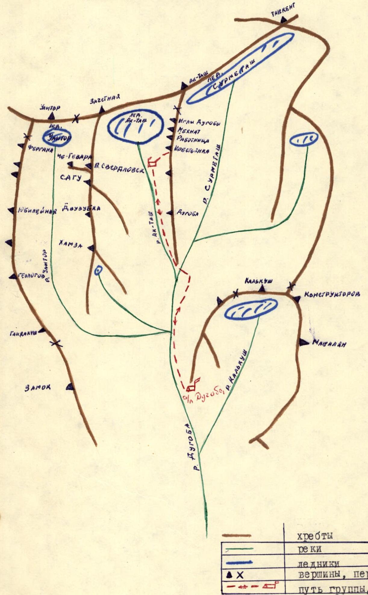
Dgoba alpine camp area, Pamir-Alay
"Krestyanka" peak 4200 m 4150
Description
Route along the right ridge of the Eastern wall by the seminar group of the Pamir-Alay region tourist club (approximately 35 km of trails)
- Guzeev V.V. — 1st category — leader
- Kudinov N.S. — 1st category — participant
- Markov A.V. — 2nd category — participant
- Plokhotny V.V. — 2nd category — participant
Public rescue team of the Pamir-Alay region tourist club Coach — CMS Lukashovich G.A.
Route description
"Krestyanka" peak, elevation 4200 m, is located in the Pamir-Alay range, Dgoba alpine camp area.
From Dgoba alpine camp, the approach to "Krestyanka" peak goes along the left side of the Dgoba river; reaching the first confluence, we make our way to the bivouac at 2nd confluence — 2–2.5 hours. From the bivouac, passing through a canyon, we enter the Ak-Tash gorge. We follow the well-trodden path to "Nizhnie Ak-Tashskie" bivouac — 1.5 hours.
Leaving the bivouac at 7:00, crossing the Ak-Tash river, and traversing the scree slopes, we approach a wide couloir that turns into slabs in its upper part. Here, we rope up and ascend snow-covered slabs for 80–100 m until we reach the start of the route.
The route begins and proceeds along the broken rocks visible on the left; rocks of moderate steepness (3 pitons hammered in) lead to a destroyed rib, which takes us to a ledge with scree. Belay via outcrops, rocks are broken, 40 m, 45° steepness. On the ledge, to the right, a intermediate cairn was set up.
From the right, we approach the first "gendarme". It is climbed with piton belay, 85° steepness, 10–13 m long (2 pitons hammered in). The second "gendarme" is climbed on the left, rocks are broken, belay via outcrops. The third "gendarme" is climbed head-on, belay via outcrops, 15 m, 45° steepness. The fourth "gendarme" is a challenging section. 85° steepness. Rocks are not heavily broken, piton belay, 3 pitons hammered in.
Next, we approach a destroyed, not very pronounced counterfort, 40–50 m long, 5 pitons hammered in. After the counterfort, we approach an internal corner, which is climbed along its left side. Rocks are not heavily broken, 60 m long, piton belay, 5 pitons hammered in.
We emerge onto a straightforward gentle ridge. Simultaneous belay. We reach the gentle pre-summit ridge. It is uncomplicated, traversed simultaneously, 250 m to the summit.
The descent was made towards "Dgoba" peak to the first scree-filled couloir, which practically leads to "Nizhnie Ak-Tashskie" bivouac in its lower part.
| Date | Sections | Average steepness of section, ° | Length of section, m | Terrain characteristics | Diff. grade | Means of movement, belay | Weather conditions | Time spent on bivouac | Rock pitons | Ice pitons | Drill holes | Bivouac conditions |
|---|---|---|---|---|---|---|---|---|---|---|---|---|
| Nov 9, 1980 | R0–R1 | 40 | 80 | broken rocks | 2 | simultaneous | clear, cold | - | - | - | - | - |
| R1–R2 | 55 | 60 | slabs | 3 | piton belay | -1 °C | - | 3 | - | - | - | |
| R2–R3 | 45 | 40 | broken rocks | 2 | via outcrops | -1 °C | - | - | - | - | - | |
| R3–R4 | 25 | 35 | slabs with scree | 1 | simultaneous | -1 °C | - | - | - | - | - | |
| R4–R5 | 85 | 10 | rocks | 4 | piton belay | -1 °C | - | 2 | - | - | - | |
| R5–R6 | 50 | 30 | broken rocks | 3 | via outcrops | -1 °C | - | - | - | - | - | |
| R6–R7 | 45 | 15 | -1 °C | 3 | via outcrops | -1 °C | - | - | - | - | - | |
| R7–R8 | 85 | 12 | rock | 5 | piton belay | -1 °C | - | 3 | - | - | - | |
| R8–R9 | 60 | 40 | destroyed counterfort | 4 | piton belay | -1 °C | - | 5 | - | - | - | |
| R9–R10 | 60 | 60 | internal corner, left side | 4 | piton belay, outcrops | -1 °C | - | 5 | - | - | - | |
| R10–R11 | 35 | 40 | broken rocks | 2 | simultaneous | -1 °C | - | - | - | - | - | |
| R11–R12 | 25 | 250 | scree | 1 | simultaneous | -1 °C | - | - | - | - | - |
Ascent area map