Konstructors (4100), Cat. 3B, via W ridge Yu. Emelyanenko, 1969
-5-
Access Routes
From the Dugoba tourist centre, the route lies along the Kalkush gorge on the left (orographically) bank of the Kalkush River. Having passed under the slopes of the UROZHAI Peak, we ascend a steep, coarse scree to a large meadow. On the left, the meadow is bordered by the Kalkush Glacier moraine, and on the right by a ridge separating the Kalkush gorge from the Mashalyan gorge. At the end of the meadow, between two streams, near a large boulder, there are camping sites. The meadow is lit by the sun comparatively early. The meadow is called "Solnechnaya" (Sunny). The journey from the Dugoba tourist centre to Solnechnaya meadow takes 4.5–5 hours.
A second access route is possible (in case the base camp is located near the second confluence – the confluence of the Ak-Tash and Dugoba rivers): via the Kalkush Pass and then along the Kalkush Glacier moraine to Solnechnaya meadow (the meadow and the ascent route to the summit are clearly visible from the pass). The journey takes 3–3.5 hours.
From the camping site, the route lies westwards, along the boundary between the left (orographically) moraine bank and the grassy slope. The ascent proceeds with little gain in altitude almost to the end of the gorge, along wide, gentle, fine scree. Then we turn right and start ascending the ridge along the boundary between the rocks and the scree, bypassing on the left a needle-shaped grey "gendarme". Reaching the ridge is not technically difficult. The time taken to travel from the camping site to the ridge is 50–60 minutes. Here is the 1st control cairn and the start of the route to the unnamed peak located to the west.
The ridge drops into the Mashalyan gorge in 300–500-metre walls.
The ridge, approximately 250 m long (steepness up to 40°), is traversed simultaneously and leads to the first wall. The steepness of the wall is 90°. From here, technically challenging work begins.
The wall is bypassed on the left via an internal corner (10 m). Then, along rocks with a steepness of 70°, we travel about 8–10 m under the red "gendarme" (Fig. 2). The "gendarme" is bypassed on the right along the wall (85°–90°). The movement occurs in two stages:
- First, along a narrow (no more than 15 cm), not very pronounced ledge – 6 m;
- Then an ascent along the wall at 85° (2.5 m) to a platform behind the "gendarme" (Fig. 3).
The length of the section is 30–35 m; 5 pitons are driven. On the "gendarme" is the 2nd control cairn.
-6-
Further along the wide ridge (steepness about 30°), we traverse simultaneously for 25 m to a 15-metre wall. The wall is climbed head-on (Fig. 4). About 2/3 of the wall has a steepness of 85°, then the steepness decreases slightly, and at the top, there is a platform. On the platform, there is a good protrusion. The wall is climbed with 3 pitons. At the top, there is belay via the protrusion.
From the protrusion, we travel 4 m left to a ruined internal corner. The corner has a large number of holds. The steepness of the corner is about 80°, the length is 20 m. 2 pitons are driven. The corner leads out onto the ridge (Fig. 5). Here the third control cairn is set up.
From the cairn, movement is along the ridge to the right. The ridge is gentle, in places wide (up to 5 m), in places narrow (down to 0.3 m). The length of the ridge is 3 rope lengths. Movement along the ridge is simultaneous. The ridge leads to the summit. The summit is dome-shaped (Fig. 6).
The ascent to the summit is made from a wide platform along a wall 3–3.5 m high, with a steepness of 90°.
The group dedicated their ascent to the 30th anniversary of the Special Design Bureau of the Ministry of Machine Tool and Instrument Making and requested that the peak be named:
Konstructors Peak
The ascent to the summit from the camping site took 5 hours. In addition to the note from the summit, the group submitted notes from the 3 control cairns for the ascent report.
-7-
The first ascent of the route was made by a group of qualified climbers from the Dugoba tourist centre in August 1969, with the following composition:
Emelyanenko Yu. – leader, Atadzhanov A. – member, Valiulin E. – member, Nazarov V. – member, Nikonorov E. – member, Kuligina L. – member.
The group assessed the route as Cat. 3B.
In the 1969 season, two more groups (a group of 6 qualified climbers and a group of 4 instructors) ascended Konstructors Peak via the described route and confirmed its Cat. 3B complexity.
Recommendations from the first ascensionists for a group of 6:
- Rock pitons – 10 pcs.
- Hammers – 2 pcs.
- 40 m ropes – 3 pcs.
- Carabiners – 15 pcs.
- Helmets – for all members.
The description was compiled by Yu. Emelyanenko.
Fig. 2

Fig. 4.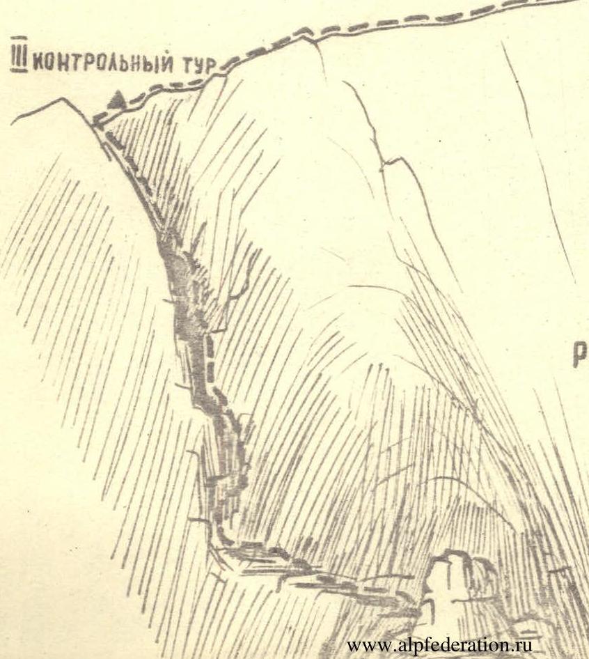
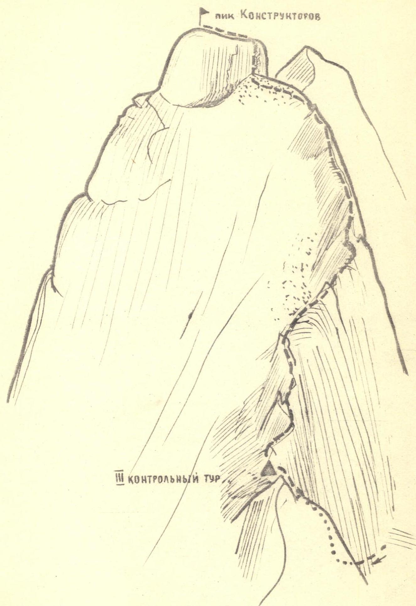
Fig. 6


