42
DESCRIPTION OF THE ROUTE TO THE SUMMIT OF KALKUSH
VIA THE EAST FACE
Team: G.G. Andreev, CMS, team leader O.I. Shumilov, CMS V.P. Veiko, CMS Yu.A. Logachev, CMS
The route was completed on July 12-14, 1969
The summit of Kalkush is located in the Pamir-Alay region, near the "Dugoba" health resort. The height is 4250 m. There are classified routes to the summit of Kalkush: 2A, 3A category of difficulty and 5A category of difficulty via the west face. The east face of the summit is extremely appealing from an alpinist's point of view: the rocks are monolithic, and the face consists of several steep ascents. The average steepness of the face is 60-70°, and the length from the start of the route to the exit onto the ridge is 600 m.
A photograph of the east face taken from the summit of SAGU, from where the face is visible from the beginning to the summit, and photographs of individual sections taken during the ascent are shown below. Below is a description of the route broken down into sections.
R1. July 12. From the "Dugoba" health resort, follow the trail to the second confluence and, turning right from the confluence of the Ak-Tash and Surmitash-davan rivers, towards the Kalkush pass. Further, traversing the scree slope to the left, the face rising to the ridge of the Kalkush summit, initially fragmented, gradually becomes more monolithic. The route is unmistakably recognizable - the most monolithic and at the same time the most impressive face. To the left of the face is a wide chimney with two plugs - rocks about 10 m in size. Below this chimney on the scree is a rocky outcrop. Overnight stay below the face. From the camp - 6-7 hours. A more convenient overnight stay is possible lower down, near the Surmitash-davan river.
R2. On the same day, the start of the face was processed. Straight up the left wall of the chimney - the climbing is moderate. About 100 m higher is the main control cairn. From the control cairn, a bastion rises upwards - along its right wall, initially along a ledge; then the ledge turns into a steep inner corner, abutting against a sheer wall 4 m high. The rocks are rough but lack convenient holds - the climbing is challenging, and in the upper part, very challenging. 7 pitons were hammered in this section (mainly channel pitons are used on the east face; the cracks are either very wide or extremely narrow - in which case petal pitons are used). Exit to the narrowest part of the face - the second bastion, about 10 m wide. End of processing.
R3. July 13. Departure at 6:00, after the control cairn - along the pre-fixed ropes to under the second bastion. It is passed on the right-hand side, transitioning into the inner corner. Up the inner corner for about 15 m, then it turns into an overhanging corner (photo 1). From this point, to the left along the smooth wall - the climbing is extremely challenging - under an overhanging rock capping the bastion. Exit onto the 2nd bastion using pitons as additional holds. 8 pitons hammered.
R4. Upwards along ascents resembling "ram's foreheads," though quite rough, for 100 m (photo 2) - 4 channel pitons and 3 petal pitons. Exit to under a wall about 100 m wide. Passed on the left-hand side.
R5. In the left-hand part of the wall upwards, then to the left (photo 3) with an exit not to the top of the wall but onto an inclined ledge. Backpacks are pulled up. 6 pitons.
R6. Along the ledge to the left, then upwards via a cleft (photo 4) - climbing is challenging due to the complete lack of holds in the lower part.
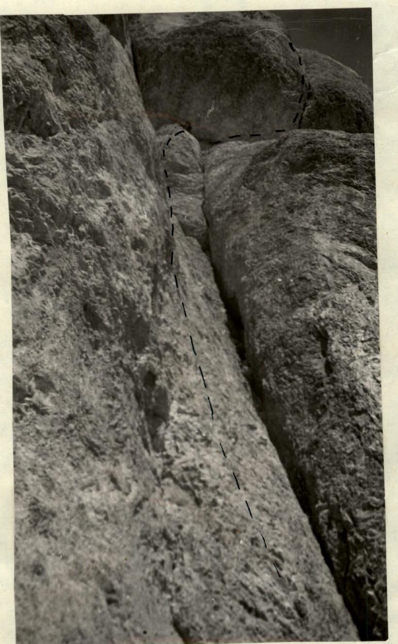
R7. Exit onto a scree platform. In the left-hand part of the wall rising from the platform, a chimney is clearly visible. Up the chimney for about 10 m, climbing is challenging, then the chimney ends - further up the wall to the right in the direction of a small scree platform. 5 pitons. (photo 5).
R8. A 50 m wall with microscopic holds. To the right remains a cleft, along which movement is impossible - the walls are smooth. The wall's steepness is about 80°, climbing is extremely challenging, with great difficulty, three intermediate petal pitons and 1 channel piton were hammered. Exit onto a ledge under an overhanging wall via a slightly overhanging rock (photo 6).
R9. Along a narrow ledge to the right for 6 m and upwards via a crack in the overhanging wall for 4 m. 3 pitons.
R10. About 60 m of moderate difficulty climbing to the ridge of the Kalkush summit. Along it, to the left along the ridge, 3A category of difficulty to the summit. Descent is possible either via the 2B category of difficulty route or 3A category of difficulty to the Kalkush pass. The team preferred the second descent option via the Kalkush pass. Overnight stay below the face. July 14 - return to the health resort. Total time spent on the face (processing 12 hours 7 minutes and climbing 13 hours 7 minutes) 17 hours. Pitons hammered - 40 during ascent and 1 during descent. The team believes that the route to the Kalkush summit via the east face should undoubtedly be classified as a 5A category of difficulty route. (In terms of climbing complexity, the route exceeds the complexity of 5A category ascents in places, but due to its relatively short length - 600 m - it cannot be classified as more complex).
Description compiled by G.G. Andreev, photographs by Yu.A. Logachev.
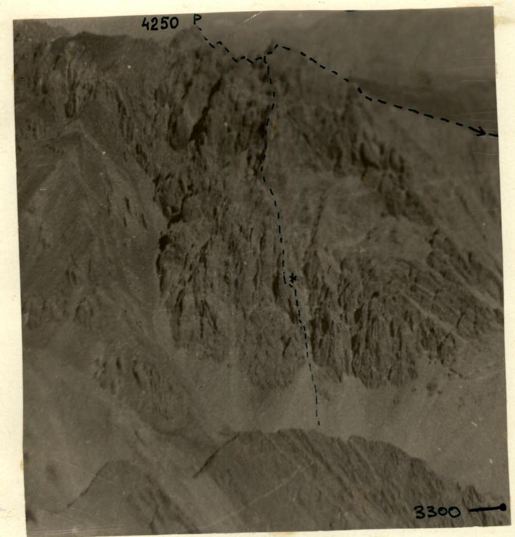 General view of the Kalkush summit's face from the SAGU ridge.
 Photo 5. Section 7. Chimney.
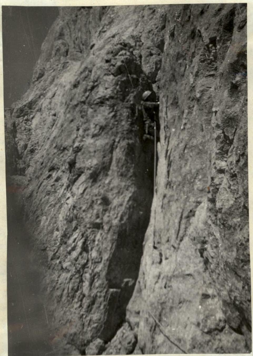 Photo 6. Section 8. Holds are small, with a "reverse" slope.