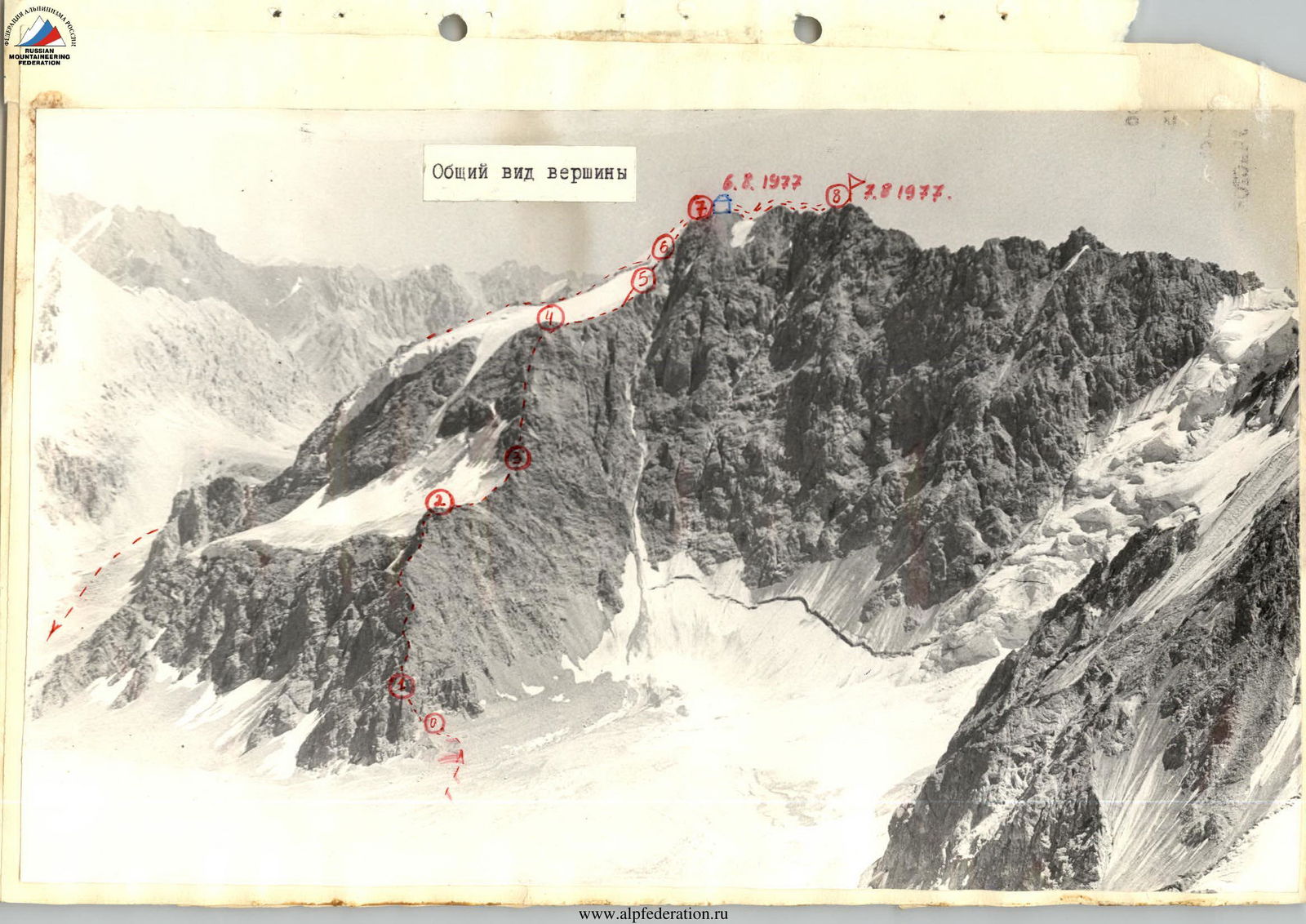
Ascent Passport
-
Pamir-Alay. Alay Ridge.
-
Peak Zvezdny 4780 m (approximately via NW ridge). First ascent.
-
Category 4A difficulty.
-
Height difference — 800 m. Section 5 — 40 m. Average slope 45°.
-
Pitons driven: rock — 35
ice — 10
-
Ascent 14 hours.
-
Overnight on the pre-summit ridge. On fine rubble.
-
Leader — Perlov Mikhail Semenovich, 2nd sports category.
Participants: Orlov Oleg Leonidovich, Candidate for Master of Sports; Baranenko Vladimir Dmitrievich, 2nd sports category.
-
Coach — Saprykin Vasily Danilovich, Master of Sports, senior instructor.
-
from August 6, 1977 to August 7, 1977.
 From the Archa-Kanysh gorge from the "blockage" along the river, flowing from the Kosmonavtov horseshoe 4 hours to the Kosmonavtov glacier.
From the base camp in the Kosmonavtov glacier cirque, the approach to the route takes 1 hour. The route begins on the right side of the northwest ridge. Ascending via the more gentle rocks on the left (north) side of the ridge is very dangerous due to their extreme deterioration and rockfall hazard.
SECTION R0–R1. Ascend via 80° slabby rocks, blocky rocks. First rope — steep stepped slabs, difficult climbing, monolith, (5). (The difficulty assessment is based on the methodology proposed in the book by Naumov A.F. "Karugom, Ligoria, Tsey", published by FiS 1976). Second rope — more gentle rocks 70–80°, many loose rocks. (Category 4 difficulty). Piton protection (10 pitons). Exit onto the ridge.
SECTION R1–R2. Further movement is along the ridge, which is a slabby gendarme 5–10 m high (60–80°), overcome head-on and mostly from the right. Protection via outcrops and pitons. The length of the ridge section to the first scree shoulder is 400 m. Two ropes before the shoulder, under a gendarme, there is a control cairn (Category 3 difficulty). 9 pitons driven.
SECTION R2–R3. Scree shoulder. Simple rocks. 120 m (Category 2 difficulty). Simultaneous movement.
SECTION R3–R4. From the first scree shoulder begins a steep rocky, not clearly defined crest, heavily destroyed. Rocks are feather-like (60–70°). Many loose rocks!! In places, walls 7–10 m high. Protection via outcrops and pitons. The extent of the ascent to the next shoulder is 8 ropes (320 m). The last large gendarme is bypassed on the right. The ascent leads to the 2nd shoulder, which has convenient areas for overnight stays. Climbing is tense due to rockfall hazard (Category 3 difficulty). 11 pitons driven.
SECTION R4–R5. 2nd scree shoulder. Simple rocks — 160 m (Category 2 difficulty). Simultaneous movement.
SECTION R5–R6. From the second shoulder to the pre-summit ridge leads a steep rocky, destroyed ascent, bounded on the left by an icefall. Initially, movement is along the boundary of rocks and ice, then along a rocky crest, which is a steep rocky ascent (70–80°), forming walls 10–15 m. Rocks are destroyed. Climbing is tense (Category 3 difficulty), protection via outcrops and pitons. Section length — 100 m. 7 pitons driven.
SECTION R6–R7. In the upper part of the ridge, it is impossible to provide protection on the rocks due to their extreme deterioration and rockfall hazard. Therefore, it is necessary to move left on the ice, initially steep (60–50°), then becoming more gentle. Do not exit onto the rocks (loose rocks!!). The ice slope is overcome in crampons, protection via ice screws (8 pcs.) (Category 4 difficulty). We exit onto the pre-summit ridge.
SECTION R7–R8. The pre-summit ridge is heavily indented, leads to the summit through two gaps. (6 ropes. Protection via outcrops. (Category 2 difficulty)). Gendarmes after the second gap are bypassed on the left. On the pre-summit ridge before the gap, there are convenient areas for overnight stays.
Descent initially follows the ascent route to the point where the NW and NE ridges converge. Further descent is along the NE ridge to the "Devяти" pass. The first two ropes are along a steep ice-rock ridge with alternating protection. Then 20 m rappel from the ridge to the western part through a bergschrund to a more gentle slope and further exit back onto the ridge, which after five ropes leads to a scree couloir descending to the east, onto the glacier. Along the boundary of ice and scree, descent through the "Devяти" pass into the base camp.
Time taken for sections:
- From the start of the route to the first shoulder – 5 hours.
- From the first to the second shoulder – 4 hours.
- From the second shoulder to the pre-summit ridge – 4 hours.
- Along the ridge to the summit – 1 hour.
- Descent from the summit to the glacier – 3 hours.
- Further to the camp – 2 hours.

Table of technical characteristics of the route — via the northwest ridge of Peak Zvezdny
| Designation | Average slope | Length, m | Character of terrain | Difficulty (cat. diff.) | Weather conditions | Pitons (rock) | Pitons (ice) | Bolts (rock) | Bolts (ice) | Time of exit and stop for bivouac, hours (bivouac conditions) |
|---|---|---|---|---|---|---|---|---|---|---|
| R0–R1 | 70° | 80 m | Slabby blocky rocks. Chimney | 4-5 | Second half of section destroyed. Fog, snowfall. | 9 | 1 | 0 | 0 | Free climbing. August 6, 1977 at 5:00 approached the route. |
| R1–R2 | 20° | 400 m | Ridge with small slabby gendarmes 7–10 m | 3 | Ridge is monolithic, windy. | 9 | 0 | 0 | 0 | |
| R2–R3 | 120 m | Scree ledges | 2 | 0 | 0 | 0 | 0 | 5 hours | ||
| R3–R4 | 50° | 320 m | Feather-like rocks | 3 | Heavily destroyed. | 11 | 0 | 1 | 0 | |
| R4–R5 | 160 m | Scree, snow-covered ledges | 2 | 0 | 0 | 0 | 0 | 9 hours | ||
| R5–R6 | 45° | 100 m | Slabby, not clearly defined ridge | 3 | Heavily destroyed, partially snow-covered. | 7 | 0 | 0 | 0 | |
| R6–R7 | 45° | 80 m | Ice. Snow-covered | 4 | Snow-covered. | 0 | 8 | 0 | 0 | |
| R7–R8 | 240 m | Ridge. местами snow-covered, monolithic | 2 | 0 | 0 | 0 | 0 | 13 hours. Stopped for overnight stay at 19:00. Ridge provides good bivouac conditions. August 7, 1977 at 8:00 continued movement, at 9:00 reached the summit. Descent at 12:00 reached the glacier, at 14:00 arrived at base camp. |

