Dugoba. Maly Zamok. Aleksey Tyulyupo
Lyosha Tyulyupo is currently in Dugoba, climbing in the mountains. He would have written this himself, but the internet there is, let's say, unstable. So, he asked me to post a couple of updates, sending the materials through an opportunity. And that's what I'm doing :0))
The first post is about a new route on Maly Zamok (4A) - a description and some thoughts on the topic....
This spring, an article about a new 3B route on Maly Zamok - the mountain closest to the Dugoba alp camp - appeared on "Risk". The experience of the summer gatherings showed that the route turned out to be very much in demand.
However, few people know that a 4A route was laid out on the same wall. There were no enthusiasts to climb it during the May gatherings, so I didn't hurry with the report.
A few days ago, we made a second ascent and:
- equipped the stations with bolts.
Now, we can safely recommend this route to gathering participants with good rock climbing training.
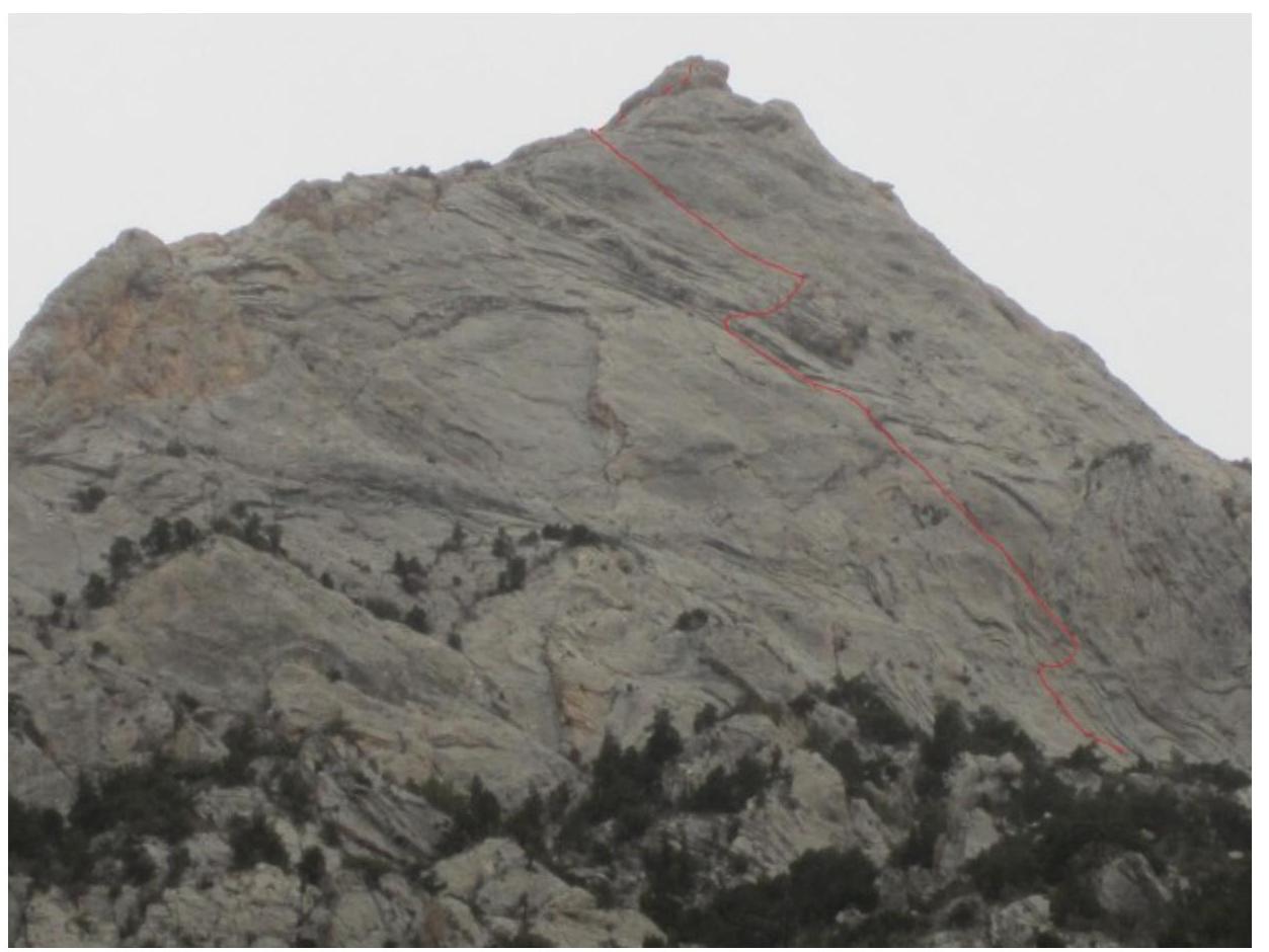
First, the description, then a bit of lyricism. The approach to the route starts from the Dugoba alp camp - up the road. Before the first bridge, you should turn left and climb 500 m up a grassy, forest-covered slope, bypassing the rock masses. The approach from the camp takes an hour to an hour and a half. The wall begins at an altitude of 2800 m.
R0–R1, 40 m, 75°, IV. The route starts in the right part of the wall - along the gentle slabs, in the direction of the chimney (a few meters to the left of the vertical gray grooves). The station is on a ledge.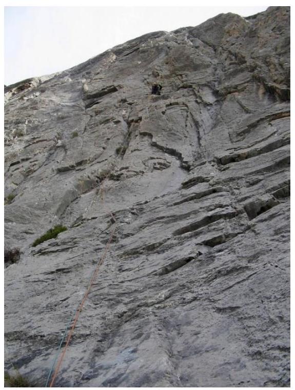
The first rope R1–R2 30 m 75° IV+. From the station, a difficult transition to the right along a small ledge and slab, and then up and to the left along a wide internal corner.
R2–R3 35 m 75° V. Continue moving along the internal corner, the station is to the left, below a large cornice in the center of the wall.
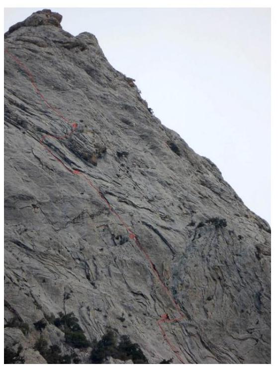
Option 1
R3–R4 30 m 75° V. Along the corner and slabs directly above the station, bypassing the overhang, climb above the large cornice and move traversing to the right, onto a ledge.
Option 2
R3–R4 20 m 80° V+. From the station, along the slab to the right, climb over the overhanging corners, and then, along the slab with poor relief under the points (there is 1 bolt), move to the ledge above the large cornice.
R4–R5 45 m 85° VI
Along the slab to the left and up, in the direction of the crack-groove:
- For insurance, you can drive anchor hooks into the cavities.
- The crack leads to a short overhang, which is climbed directly up (6b, good insurance with friends and anchor hooks).
- After it, the crack continues and leads to a flattening before the ridge.
- The station can be made on a tree behind the bend.
The last rope R5–R6 300 m 45° II–III
Along the simple, destroyed ridge, move initially along the wall, and then in the direction of the summit. The ridge leads to the descent path, 200 m below the summit.
In general, the route turned out to be very logical, the climbing is quite even, with a pronounced key on the last rope. Unfortunately, we couldn't climb the wall to the very highest point. However, as it turned out, the relief allows climbing even where it looks like a bare wall from below, so we want to create another thread - along the right edge or along the internal corners between the existing 3B and 4A routes. Or rather, we want someone else to make another thread - so, if someone else climbs it, we won't be offended.)
To make it easier to navigate:
- Here's a general photo of the wall.
- I'll try to climb to the opposite slope in the near future, take photos of the wall from a less sharp angle, and post the photos on the site www.dugoba.com↗.
Now, when the main thing is said, I'll allow myself a bit of chatter about the impressions of the route and free-thinking on the topic of how such routes should be classified, equipped, and, in general, why they are needed.
For those who are not aware, Dugoba is an alp camp in the Pamir-Alay, from which you can climb many interesting peaks under 5000 m and a bit higher. The weather here, as a rule, allows for the most serious ascents from the beginning of May to the middle of October.
What explains the increased interest in the massif of the mountain closest to the camp, with a height of less than 4000 m? On the one hand, new routes on Maly Zamok make up for the not-too-high technical complexity of most routes in the area. For example, the comrade with whom we made the second ascent of the 4A on Maly Zamok had previously climbed 5B on Pik Konstruktorov. So, there, on the 5B, they estimated the maximum complexity of climbing as 6A. What's there to say about simpler routes?
It's great when third-class climbers:
- learn on distant and labor-intensive peaks,
- climb kilometers of ice and rocks of III-IV category.
Only on them can you forget how to climb with two jumars, and then imagine that a rock climbing level of 5c onsight is enough in the mountains.
In general, I consider the routes on Maly Zamok to be completely uncharacteristic for the entire area, and this, in any case, can only be welcomed. Moreover, they are close, and can always be left for a case of bad weather: heavy rains in Dugoba are very rare, but sometimes a haze pulls in, making it unpleasant to climb distant routes.
I also want to say what future I wouldn't like for these routes.
First, I want to ask:
- not to hammer anything else there
- not to mark with paint
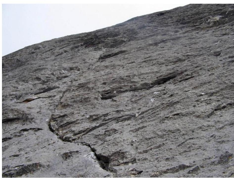
The absence of bolts on the key is not accidental. I myself, when I climbed there for the first time, took a drill and several bolts with me - it all looks very monolithic, but it turned out that it's easy and pleasant to insure with one's own points.
If something is hammered in permanently, the route will lose a lot. On the stations, one bolt is hammered (10 mm diameter, 100 mm+ length), on each - in case of an unforeseen descent. In addition, on the penultimate rope, in the only place with problematic insurance, a bolt is hammered as an intermediate point.
I note that the route was climbed twice without bolts at all, they were hammered near the stations, assembled by the leader on his own points. In my opinion, this is the optimal training option, allowing:
- to safely practice the organization of stations
- to bail out in case of something
In principle, for rappelling, 60 m of rope should be enough almost everywhere. However, it's not recommended to plan a descent along the ascent route in advance.
Further, the topic of marking directions on routes with paint, in my opinion, requires a separate discussion. Yes, groups that find 5s on 2s are constant suppliers of casualties. That's why orientation on the route is the most important skill for a climber, and where to get it, if not on walls that can be seen from the camp? After all, if doubts arise, you can always leave the radio on and use tips from the audience. And this... is the last, but not the least important.
I wouldn't like it if Maly Zamok became a place where gathering participants massively closed their categories. After all, for purely technical rock climbing routes, you need to go to:
- Crimea
- Ergaki
And here there are much more interesting mountains, and this season we'll definitely climb new first ascents on them and tell you about them as part of the "Lonely Peaks of Dugoba" project.
P.S. The day before yesterday, a group of second-class climbers climbed this route: the reviews are very positive. They say the route corresponds to the category, or even pulls on 4B. But let it be 4A - the technical complexity is compensated by the small length and height.
And one more thing: huge thanks to the administration of the Dugoba alp camp, who provided me with the opportunity to describe the routes in one of my favorite mountainous areas, and to Camp, who provided the equipment for this event.


