Ascent Passport
I. Ascent class: rock 2. Ascent area: AUSB "Dugoba", Alai ridge 3. Peak, its height, route taken: p. Dugoba 4200 m, Eastern ridge 4. Proposed category of difficulty: 3A 5. Characteristics of the route: rock Elevation gain: 3700–4200 m (500 m) Length of sections with 5th and 6th category of difficulty: none Average steepness: 45–50° 6. Pitons hammered: rock 27, ice none, bolted none Use of protection: 12 7. Number of travel hours: 8 8. Number of overnight stays: none 9. Full name of the leader and participants, qualification: KISLYAKOV Viktor Evgenievich CMS — leader BAIGUZIEV Malik Serikbaevich 2nd sports category KUDRYASHOVA Svetlana Alekseevna 2nd sports category MAKAGONOV Dmitrii Leonidovich 2nd sports category SMIRNOV Sergei Nikolaevich 2nd sports category 10. Team coach: BOCHAROV Vladimir Nikolaevich MS USSR 11. Date of entry onto the route: August 15, 1987 Date of return from the route: August 15, 1987 12. Ascent organized by: AUSB "Dugoba"
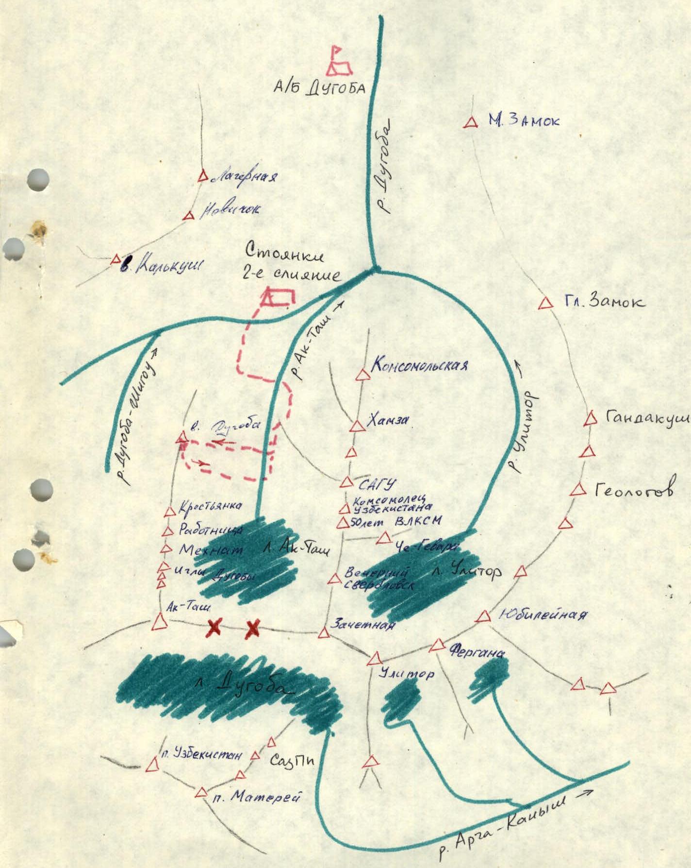
From the second confluence, ascend the steep slope on the left bank of the Ak-Tash river to the canyon. Descend into the canyon, ascend on the left side of the "ram's foreheads". After 1–1.2 km, cross the Ak-Tash river. The route follows a distinct ridge, bounded on the left by a couloir and a characteristic white streak, and on the right by a talus slope.
 — Proposed route (approximately 3A category of difficulty)
— route via the North ridge, 2A category of difficulty
— route via the East slope of the North ridge, 2B category of difficulty
— Proposed route (approximately 3A category of difficulty)
— route via the North ridge, 2A category of difficulty
— route via the East slope of the North ridge, 2B category of difficulty
Ascent area diagram
Route diagram and tactical plan for ascending p. Dugoba via the Eastern ridge, 3A category of difficulty (approximately)
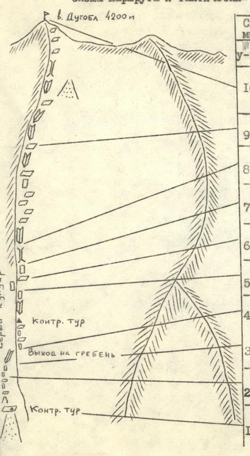
 p. Dugoba 4200 m
Descend from the summit along the North ridge towards p. Krestyanika for 200 m, then from the saddle into the Ak-Tash or Dugoba-Shigou gorge.
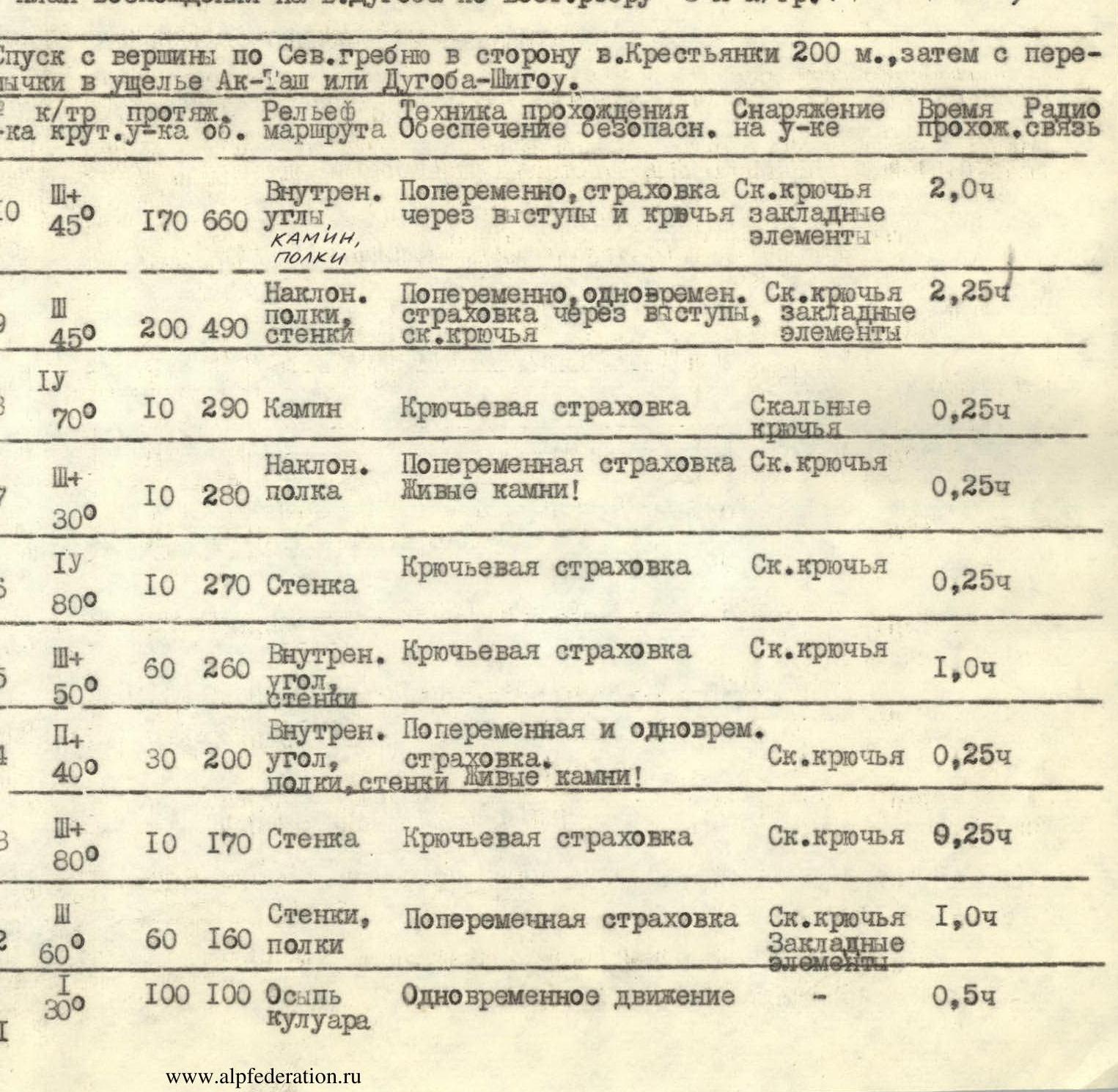
- R10, category of difficulty 3+, length of section 170 m, steepness of slope 45°. Terrain: internal corners, chimney, ledges. Technique: alternating movement, protection via outcrops and pitons, protection. Equipment: rock pitons. Time: 2 h 00 min.
- R9, category of difficulty 4, length of section 200 m, steepness of slope 45°. Terrain: sloping ledges, walls. Technique: alternating movement, simultaneous protection via outcrops, rock pitons, protection. Equipment: rock pitons. Time: 2 h 15 min.
- R8, category of difficulty 4, length of section 10 m, steepness of slope 70°. Terrain: chimney. Technique: piton protection. Equipment: rock pitons. Time: 0 h 15 min.
- R7, category of difficulty 3+, length of section 10 m, steepness of slope 30°. Terrain: sloping ledge. Technique: alternating protection. Loose rocks! Equipment: rock pitons. Time: 0 h 15 min.
- R6, category of difficulty 4, length of section 10 m, steepness of slope 80°. Terrain: wall. Technique: piton protection. Equipment: rock pitons. Time: 0 h 15 min.
- R5, category of difficulty 3+, length of section 60 m, steepness of slope 50°. Terrain: internal corner, walls. Technique: piton protection. Equipment: rock pitons. Time: 1 h 00 min.
- R4, category of difficulty 2, length of section 30 m, steepness of slope 40°. Terrain: internal corner, ledges, walls. Technique: alternating and simultaneous protection. Loose rocks! Equipment: rock pitons. Time: 0 h 15 min.
- R3, category of difficulty 3+, length of section 10 m, steepness of slope 80°. Terrain: wall. Technique: piton protection. Equipment: rock pitons. Time: 0 h 15 min.
- R2, category of difficulty 2, length of section 60 m, steepness of slope 60°. Terrain: walls, ledges. Technique: alternating protection, protection. Equipment: rock pitons. Time: 1 h 00 min.
- R1, category of difficulty 1, length of section 100 m, steepness of slope 30°. Terrain: couloir scree. Technique: simultaneous movement. Time: 0 h 30 min.


