Ascent Passport
- ASCENT CLASS ROCK
- ASCENT AREA, RANGE PAMIR-ALAI, ALAI RANGE
- PEAK, ITS HEIGHT, ASCENT ROUTE P. 4300 VIA THE RIGHT EDGE OF THE NORTH FACE
- EXPECTED DIFFICULTY CATEGORY 5B
- ROUTE CHARACTERISTICS: ELEVATION CHANGE 730 m LENGTH OF SECTIONS WITH 5–6 DIFFICULTY 640 m AVERAGE STEEPNESS 78°
- PITS DRIVEN: FOR PROTECTION 76 FOR I.T.O. 2 ROCK — ICE — BOLTS 48 NUTS —
- TOTAL CLIMBING TIME 16 hours
- NUMBER OF NIGHTS AND THEIR CHARACTER ONE OVERNIGHT, IN A LAYING POSITION
- SURNAME, NAME, PATRONYMIC OF THE LEADER, PARTICIPANTS, AND THEIR QUALIFICATION: BELOUSOV V.M. LEADER, CMS AFANASYEV A.E. PARTICIPANT, CMS TARAN N.S. PARTICIPANT, CMS YUDALEVICH V.F. PARTICIPANT, CMS
- TEAM COACH: BELOUSOV V.M.
- DATE OF DEPARTURE AND RETURN: August 15, 1980 – August 16, 1980
TEAM CAPTAIN:
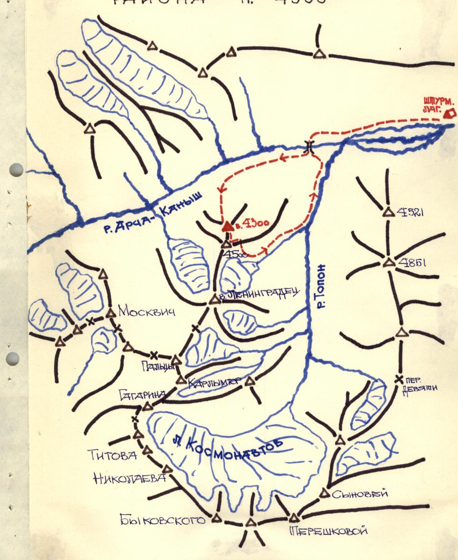
Map of the P. 4300 Area
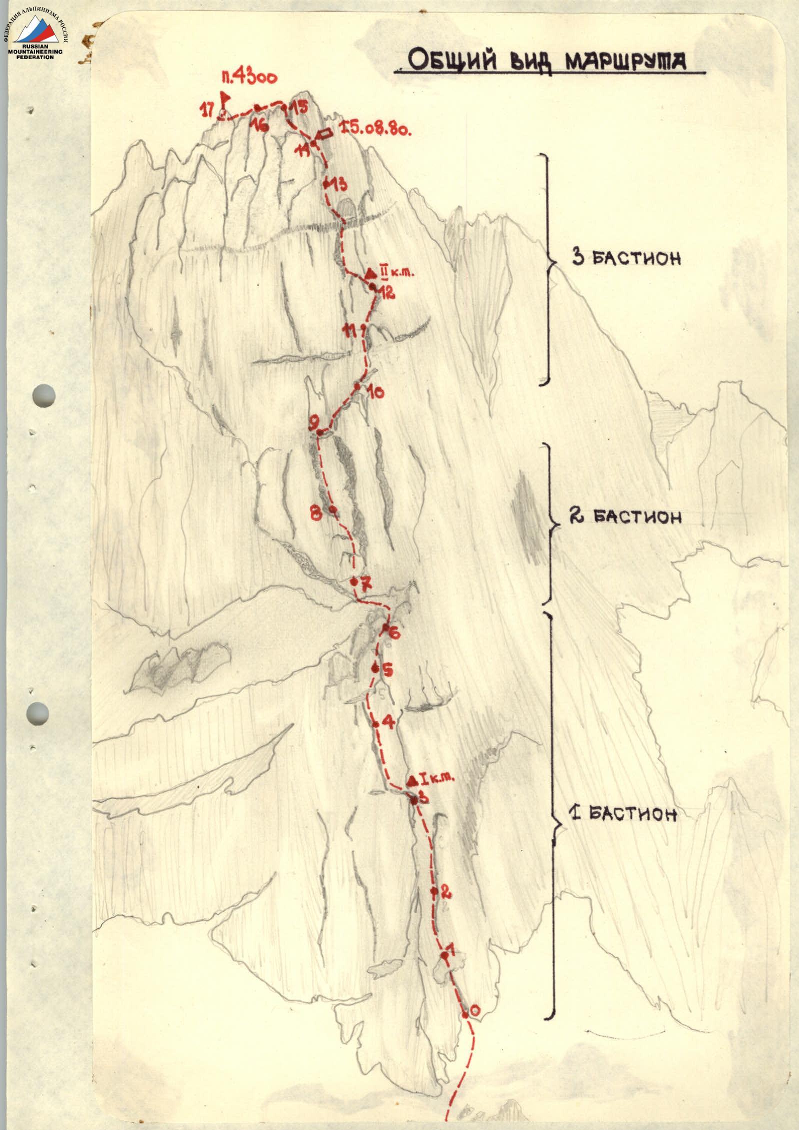
General View of the Route
Table of Main Characteristics of the Ascent Route
ROUTE TO PEAK 4300 VIA THE RIGHT EDGE OF THE NORTH FACE ELEVATION CHANGE 730 m INCLUDING COMPLEX SECTIONS 640 m AVERAGE STEEPNESS OF THE ROUTE 78° NUMBER OF PITS DRIVEN 126
| Date and Section Number | Avg. Steepness of Section | Length of Section | Characteristics of Sections and Passing Conditions (Relief) | Technical Difficulty | Protection Method | Weather Conditions | Time of Departure and Stop for Bivouac | Climbing Hours per Section | Pits Driven (Rock) | Pits Driven (Ice) | Pits Driven (Bolts/Nuts) | Overnight Conditions |
|---|---|---|---|---|---|---|---|---|---|---|---|---|
| 15.08. | ||||||||||||
| R0–R1 | 80 | 40 | Wall with an inner corner made of fractured marble | 5Б | Pitons. Clear | 8:30 | 0:40 | 5 | – | 3 | ||
| R1–R2 | 80 | 40 | Vertical slab | 5Б | Pitons. Clear | 0:40 | 4 | – | 2 | |||
| R2–R3 | 82 | 80 | Monolithic wall | 5Б | Pitons. Clear | 0:40 | 10 | – | 4 | |||
| R3–R4 | 85 | 40 | Inner corner with overhanging sections | 6 | Pitons. Clear. Ladder | 0:50 | 6 | – | 4 | |||
| R4–R5 | 85 | 40 | Inner corner transitioning into a wall | 6 | Pitons. Clear | 0:50 | 4 | – | 3 | |||
| R5–R6 | 85 | 40 | Wall with an inner corner and ledges | 5Б | Pitons. Clear. Strong wind | 0:40 | 4 | – | 3 | |||
| R6–R7 | 45 | 40 | Upper edge of the I bastion | 4 | Through strong outcrops. Wind | 0:20 | – | – | – | |||
| R7–R8 | 87 | 38 | Wall with a cleft | 6 | Pitons. Strong. Nuts. Wind | 1:00 | 5 | – | 3 | |||
| R8–R9 | 87 | 40 | Wall with a chimney | 6 | Pitons. Clear | 1:00 | 4 | – | 3 | |||
| R9–R10 | 60 | 50 | Walls resembling "sheep's foreheads" | 4Б | Pitons. Clear | 0:30 | 2 | – | – | |||
| R10–R11 | 80 | 35 | Wall with an inner corner | 5Б | Pitons. Clear | 0:50 | 5 | – | 2 | |||
| R11–R12 | 75 | 80 | Vertical edge of the wall | 5Б | Pitons. Clear | 1:40 | 8 | – | 6 | |||
| R12–R13 | 87 | 70 | Vertical edge with a transverse dark slate belt | 6 | Pitons. Cloudy. Ladder | 2:00 | 12 | – | 7 | LYING ON A PREPARED PLATFORM. | ||
| R13–R14 | 70 | 40 | Vertical edge with a small shelf at the top | 5Б | Pitons. Cloudy. Snow | 21:00 | 0:50 | 3 | – | 5 | ||
| R14–R15 | 70 | 40 | Steep rib | 5А | Pitons. Clear | 8:00 | 0:50 | 3 | – | 2 | ||
| R15–R16 | 50 | 60 | Individual smoothed blocks | 4Б | Pitons. Clear. Through outcrops | 0:30 | 3 | – | 1 | |||
| R16–R17 | 40 | 120 | Pre-summit ridge | 3Б | Through. Clear. Outcrops. Descent was made along the southern ridge through peak 4500 | 1:40 | – | – | – |
Brief Description of the Ascent Route
 The approach to the start of the route is made from the trail that runs along the stream through a grassy slope with scree. In the upper part of the slope, there are more rock outcrops resembling "spindles" and "sheep's foreheads." The approach is simultaneous, without ropes. The general direction is under the right wall of the lower bastion. See Fig. 1.
Section R0–R1
From the start of the lower wall of the bastion, move upwards through the inner corner. The rocks are composed of light-colored, coarse-grained marble in the form of huge blocks and walls with minimal cracks and holds. Inside the corner, there is a gap where, in some places, one can drive a box piton or place a large chockstone. At the end of the section, there is a slightly sloping ledge. Climbing is difficult. The first participant goes without a backpack. All participants wear crampons, which hold well on the rough surfaces of this rock type. Taran N.S. leads first, the others follow on fixed ropes with top-rope protection.
Section R1–R2
After a steep, small ledge, there is a vertical slab. One should move towards the inner corner, where the wall ends after two rope lengths. Holds are minimal, and cracks are very few. Protection is via pitons and some placed nuts. Climbing is very difficult.
Section R2–R3
The wall, about two rope lengths long, is very difficult to climb. There is a vaguely defined inner corner with a crack in the center. The walls to the left and right are absolutely monolithic, rough in structure, and vertical. Protection is on a double rope through pitons and chockstones. The wall transitions into a clearly defined inner corner at the top.
Section R3–R4
The wide inner corner has walls on the left and right that are somewhat laid back. The number of holds is minimal. The corner is climbed on friction and in stem. Some sections overhang. A ladder is used to pass the overhanging part. Climbing is very difficult. Protection is exclusively via pitons on a double rope. Other participants traverse on fixed ropes with top-rope protection using jammers. The third participant goes on double ropes, one of which serves as a safety rope (slides the second jammer). At the start of the section, there is a small ledge where Control Cairn I is built. See Fig. 2.
Section R4–R5
The inner corner of very difficult climbing, 60 meters long, transitions into a wall on the right (western) side of the bastion. The only crack is not very fissured. Free climbing is of maximum difficulty, on friction, and with minimal holds. Places for driving pitons and setting nuts are limited.
Section R5–R6
The wall with an inner corner has small, inclined ledges resembling steps with rounded edges after 7–8 meters. Between the ledges, there are walls that are climbed with very difficult moves. Protection is via pitons. At the top, the section reaches the edge of the first bastion. Up to the exit to the edge, the route goes vertically upwards with small (2–3 m) deviations to the left and right from the main direction.
Section R6–R7
Along the edge of the first bastion, it is necessary to move right and upwards through monolithic outcrops resembling "cut-offs" towards the wall of the second bastion. Climbing is of medium difficulty. Protection is through outcrops. At the end of the edge, there is a good platform for an overnight stay. Along the north wall, water seeps, and there is snow on a wide, inclined shelf under the second rock bastion.
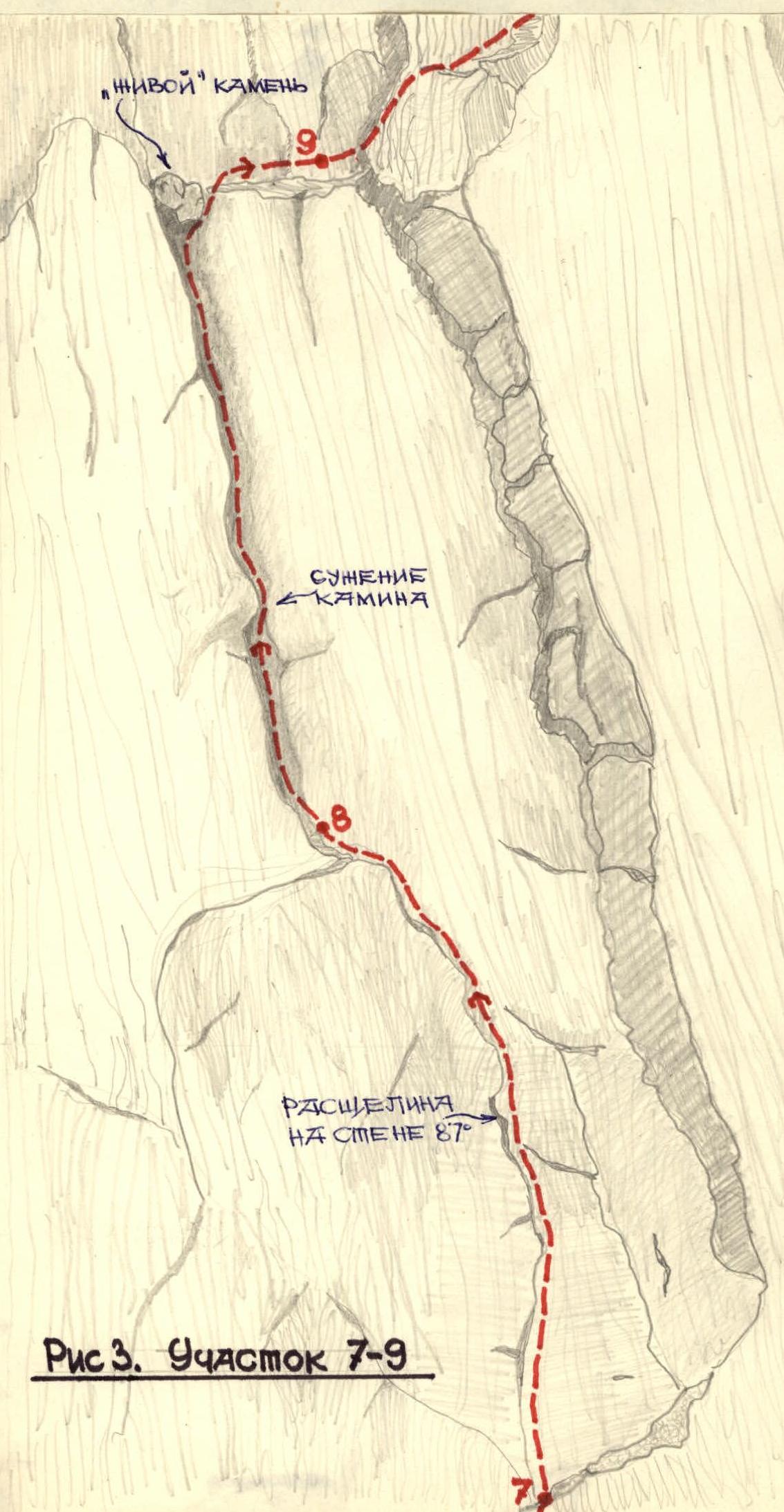
Section R7–R8
From the ledge, convenient for an overnight stay under the wall, it is necessary to simultaneously approach the corner formed by the north wall and the eastern part of the second bastion. The route goes through a cleft 3 meters to the left of the corner on the left side of the bastion. See Fig. 3. Climbing is very difficult. Protection is via pitons and nuts. Holds are limited to the cleft. On this bastion, there was a change of lead, and Afanasyev A. took the lead. At the top of the section, the crack widens into a narrow chimney. Protection:
- through pitons
- nuts
Holds are limited to the cleft. On this bastion, there was a change of lead, and Afanasyev A. took the lead. At the top of the section, the crack widens into a narrow chimney.
Section R8–R9
The second half of the route on the second bastion goes through a chimney with gently sloping, rounded edges. It is exposed. Climbing on stem and friction is very difficult. 20 meters from the start of the chimney, there is a constriction that forces one to exit the chimney and pass this place with very difficult climbing on the wall. Inside the chimney, rare pitons are driven for protection. At the top of the chimney, there are live rocks lying across. See Fig. 3.
Section R9–R10
The second bastion ends with a chimney (not very steep walls resembling "sheep's foreheads"), which further transitions into the vertical edge of the third (upper) bastion. Protection is alternating through pitons, and one rope is used for simultaneous passage. There are several ledges where one can organize a sitting overnight stay. Climbing is of medium difficulty.
Section R10–R11
The further route goes along the edge, composed of blocks and vertical walls. The first vertical wall after the not very steep edge is a monolith with an inner corner. There are very few holds and cracks. Climbing is complex. Protection is via pitons. On the first wall, it was necessary to create a living ladder from the participants.
Section R11–R12
The edge of the wall, composed of huge blocks, has a minimal number of holds and cracks. It is very complex to pass. Monolithic. There are no loose rocks. Climbing is very difficult. Protection is via pitons. Chockstones and large cams are used effectively. The entire edge is also composed of light-colored, finely fractured marble. The relief and character of the rocks are monotonous. In the corner of the vertical wall, Cairn II hangs on a cordelette.
Section R12–R13
The vertical edge continues until the exit to the ridge. After Cairn II, it is necessary to go up through a cleft to the left of the edge, which crosses a black slate belt 2 meters wide. On the slate belt, there is a ledge where two participants can stand and organize a convenient protection station. See Fig. 4.

Section R13–R14
Before and after the black belt, climbing is of maximum difficulty. Above the belt, there is an overhanging section that is passed using a ladder. The steepness in some places reaches 90°. Until then, the clear weather started to deteriorate. Strong wind with raindrops. The edge of the wall becomes more fissured. For protection, one can already drive combined pitons alongside box pitons. Protection is via pitons. Climbing remains difficult. Frequent use of a living ladder. Holds on monoliths are rare. At the top, the wall slightly flattens, forming a small shelf. There is a piece of ice in a cleft. Here, an overnight stay is organized with the construction of a platform. At 21:30, a light rain turned into snow.
Section R14–R15
On this section, the edge somewhat flattens and further transitions into a ridge. The rocks are monolithic with small shelves. Protection is via pitons. On this and subsequent sections, it is also possible to organize a platform for setting up a tent. On the north side of the edge, there are sections of ice and snow.
Section R15–R16
The route exits onto a ridge, which is structurally composed of individual, smoothed blocks of rounded shape. The blocks are monolithic. Pitons can be driven only between the blocks. Climbing is of medium difficulty.
Section R16–R17
The ridge becomes even more gentle and leads to the summit in the form of rounded blocks. Protection is through outcrops. The weather is good. They reached the summit at 11:20. On the summit, a cairn was built, and a note was left. The descent was made along the southern ridge through peak 4500 into the gorge of the Topon River.
Team Preparedness for the Ascent
The team of Otdelnyi Kombinat ZabVO in the 1980 season, in this composition, conducted a cycle of training sessions and ascents. During April and May, the team members participated in rock training and competitions in rock climbing. The pair, Taran N.S. and Afanasyev A.E., are prize-winners in the competition of Crimean pairs at the Irkutsk Region Championship. In May, the team participated in qualification gatherings held by the Irkutsk Regional Committee in the Eastern Sayan. Here, the team conducted a cycle of training sessions, training ascents, and ascents for cohesion. In July, the team members participated in gatherings in the Fann Mountains area, where they climbed peaks: "Energiya" – 5B, "Alishut" – 5B, "Soan" – 5B, "Zindon" via the north wall – 6B.
Before the start of the All-Union Championship, the team conducted an inspection of the proposed ascent route and the approach path to it. They received consultation from the first ascenders about the nature of the relief and the route passage. They selected the appropriate equipment.
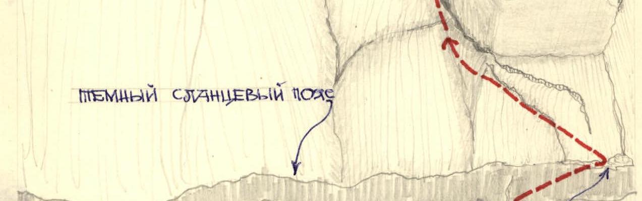 Fig. 4. Section R12–R13