Ascent Passport
- Ascent class: rock
- Ascent area: Pamir-Alai, Alai ridge
- Peak, its height and ascent route: p. 4300, via the center of the eastern wall via the route of V. Grishchenko (2nd place at the XXXI USSR Alpine Championship, rock class) with exit to p. 4450 m
- Proposed difficulty category: 5B
- Route characteristics: height difference — 800 m average steepness: wall — 80°, overall — 65° length of sections: 2nd difficulty — 120 m, 3rd difficulty — 800 m, 4th difficulty — 80 m, 5th difficulty — 425 m, 6th difficulty — 130 m.
- Pitons driven: for belaying: rock 5 ice chocks 99 for creating artificial anchorage: 17 10
- Number of climbing hours — 14 hours.
- Number of nights and their characteristics: no nights.
- Full name of the leader, participants, their sports qualification: Pershin Valery Nikolayevich — CMS — leader Balezin Valery Viktorovich — CMS — participant Chentsov Sergey Vasilyevich — CMS — participant Zakharov Nikolay Nikolayevich — CMS — participant
- Team coach: Yakovlev Vitaly Dmitrievich
- Date of departure and return: departure — August 1, 1980 return — August 1, 1980
Note: Championship teams, after passing the eastern wall, ended the ascent at p. 4450 m.
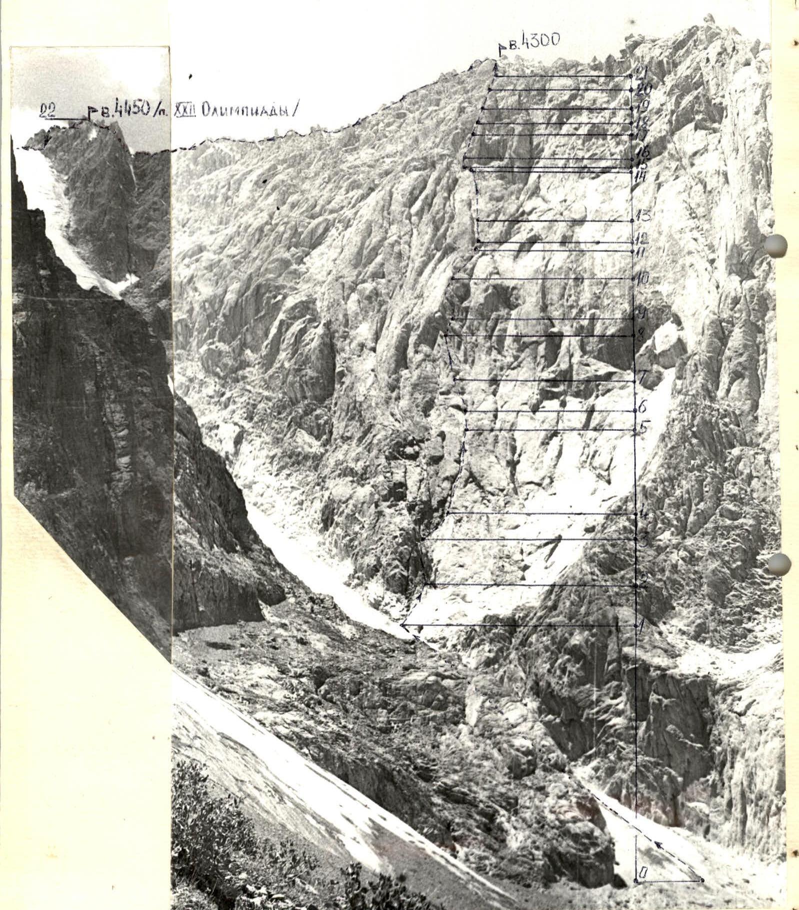
TABLE OF MAIN ROUTE CHARACTERISTICS
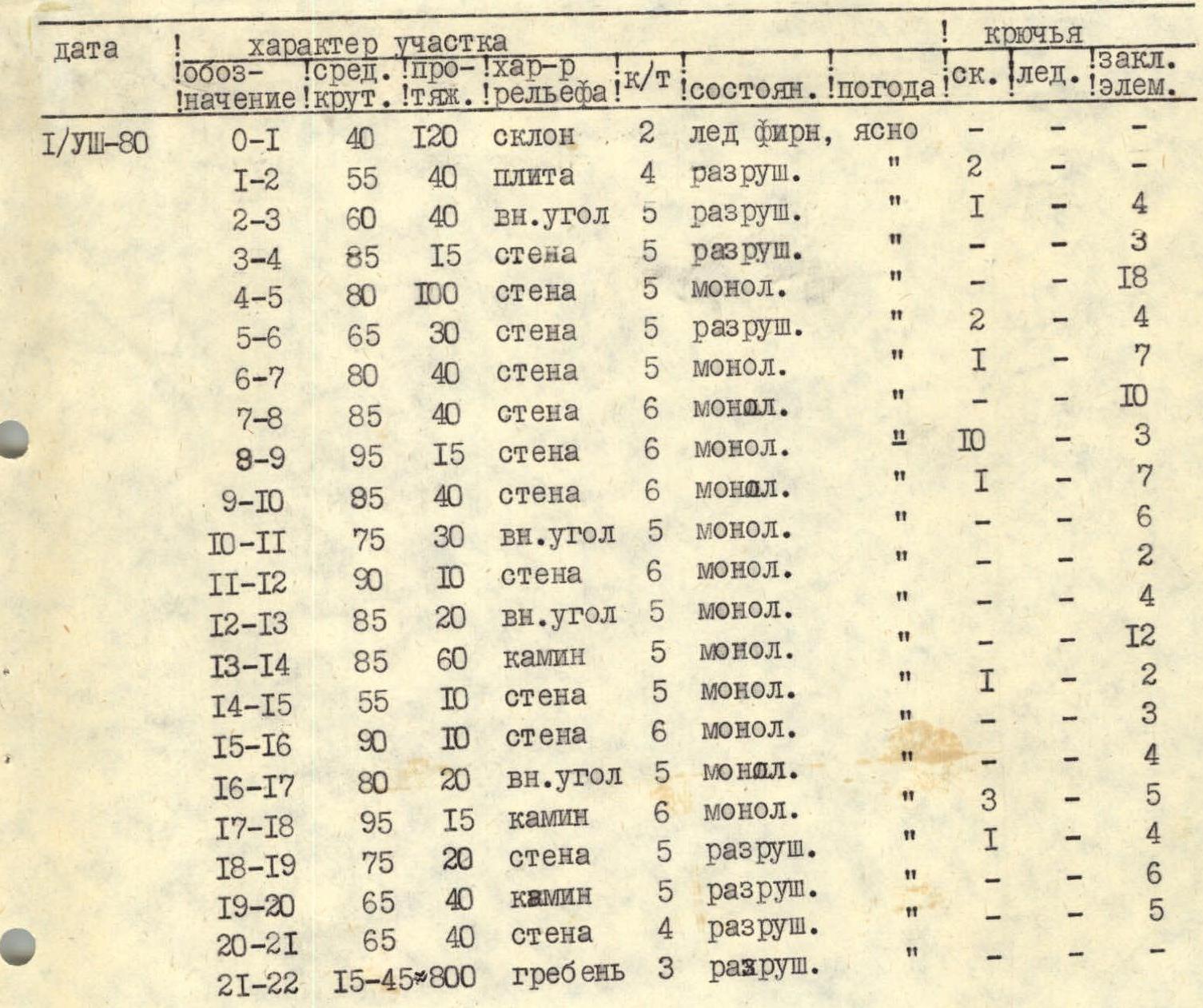
Brief explanation of the table
Section
R0–R1: Dense firn. Ice at the top. R1–R2: Stepped slabs covered with small scree. R2–R3: Wide internal angle. Many loose rocks. R3–R4: To the right, a wall with few holds leads to the start of a wide crack. R4–R5: Wide crack (10–15 cm). Walls are very smooth, friction is poor. Climbed by wedging hands and feet in the crack. Climbing is complex. Belaying with "eccentrics". R5–R6: Wall with shelves covered with small stones. R6–R8: Monolithic slabs with few holds. Climbed on friction. Climbing is very difficult. R8–R9: Overhanging wall. Climbed using artificial support points. The overhanging cornice above is passed to the right. Exit to a small inclined ledge. R9–R10: From the ledge, first up to the right, then around the overhanging "forehead" to the left and then up a sheer crack. Climbing is very difficult. Exit onto a huge stone wedged in an internal angle. Possible exit to this stone on the right. Here is a control cairn and places for bivouac. R10–R11: Internal angle. Movement along the right edge of the angle. R11–R12: Sheer wall at the end of the internal angle with a crack in the middle. Climbing is very difficult. Friction is poor. R12–R13: Internal angle leading to a chimney. R13–R14: Chimney 40–80 cm wide. Walls are even and very smooth. Few places for belaying. Leads to a small ledge at the base of a bright red bastion, which is climbed on the left. R14–R15: Wall with flakes. R15–R16: Slab, climbing is very difficult, few holds. To the right is the wall of the bastion. R16–R17: Internal angle formed by the bastion on the right and slabs on the left. R17–R18: Narrow overhanging chimney with uneven edges. Climbed using artificial support points. Ends with an overhanging smooth "forehead", which is climbed with a boost from the belayer. R18–R19: Broken rocks lead to the base of a wide chimney. R19–R20: Wide (2–3 m) easy chimney. R20–R21: Broken rocks lead to the ridge. R21–R22: Along an easy ridge to the summit. The pre-summit gendarme is bypassed on the right.