Ascent Passport
I. Ascent class - rock 2. Ascent area, ridge - Archa-Kanysh gorge, Altai ridge 3. Peak, its height, ascent route - peak XXII Olympiad, 4470 m, via the left part of the eastern wall. 4. Proposed difficulty category - 5B 5. Route characteristics: elevation gain - 750 m of which: eastern wall - 455 m length of sections - 550 m 5B-6B difficulty category average wall steepness - 82° 6. Pitons driven: rock - 72, of which ITO - 19 bolt - 5, of which ITO - 2 chocks - 69, of which ITO - 29 ice - 0, of which ITO - 0 7. Number of climbing hours: 25 hours of which wall: 21 hours 8. Number of bivouacs and their characteristics - 1 sitting 9. Leader - GRACHEV A.B., MSМК
Participants:
- OSHE E.A. - MS
- BORZOV Yu.V. - MS
- RYBAKOV M.I. - CMS
- Team coach: GRACHEV A.B.
- Departure to the route - July 10, 1980 Return - July 11, 1980
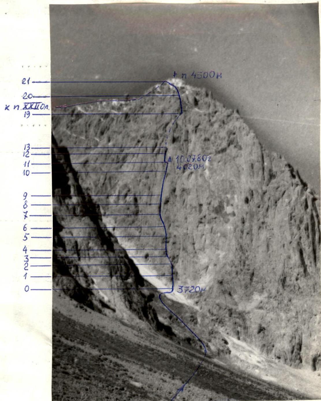
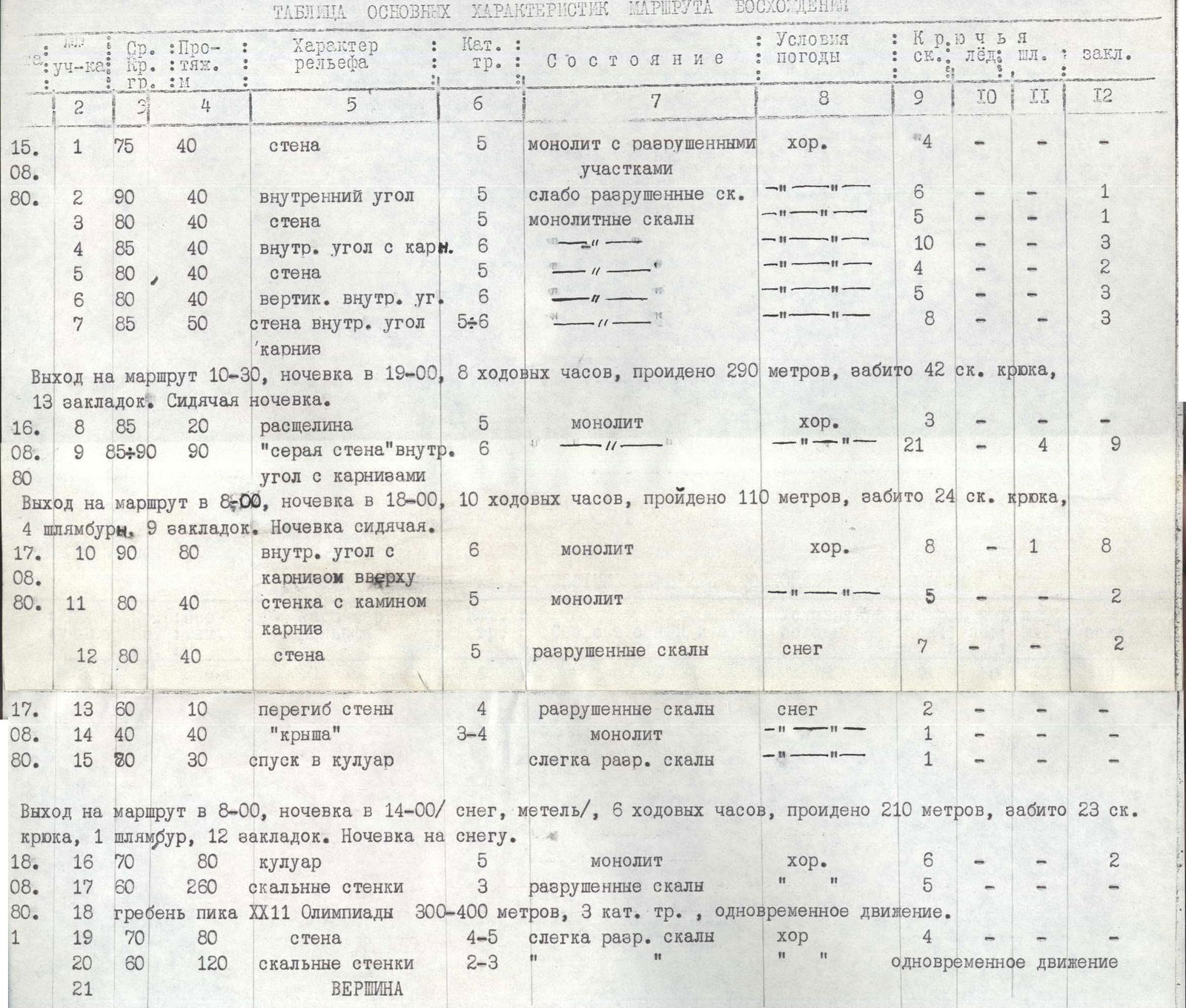
TABLE OF MAIN CHARACTERISTICS OF THE ASCENT ROUTE
| Section | Avg. steepness, ° | Length, m | Diff. cat. | Terrain character | Condition | Weather conditions | Rock pitons | Ice pitons | Bolt pitons | Chocks |
|---|---|---|---|---|---|---|---|---|---|---|
| R1 | 75 | 40 | 5 | wall | monolith with destroyed sections | good | 4 | |||
| R2 | 90 | 40 | 5 | inner corner | weakly destroyed rock | — | 6 | 1 | ||
| R3 | 80 | 40 | 5 | wall | monolithic rock | — | 5 | 1 | ||
| R4 | 85 | 40 | 6 | inner corner with cornice | — | — | 10 | 3 | ||
| R5 | 80 | 40 | 5 | wall | — | — | 4 | 2 | ||
| R6 | 80 | 40 | 6 | vertical inner corner | — | — | 5 | 3 | ||
| R7 | 85 | 50 | 5-6 | wall, inner corner, cornice | — | — | 8 | 3 | ||
| R8 | 85 | 20 | 5 | crack | monolith | good | 3 | |||
| R9 | 85-90 | 90 | 6 | "grey wall", inner corner with cornices | — | — | 21 | 4 | 9 | |
| R10 | 90 | 80 | 6 | inner corner with cornice above | monolith | good | 8 | 1 | 8 | |
| R11 | 80 | 40 | 5 | wall with chimney, cornice | monolith | — | 5 | 2 | ||
| R12 | 80 | 40 | 5 | wall | destroyed rock | snow | 7 | 2 | ||
| R13 | 60 | 10 | 4 | wall bend | destroyed rock | snow | 2 | |||
| R14 | 40 | 40 | 3-4 | "roof" | monolith | — | 1 | |||
| R15 | 80 | 30 | 5 | descent into couloir | slightly destroyed rock | — | 1 | |||
| R16 | 70 | 80 | 5 | couloir | monolith | good | 6 | 2 | ||
| R17 | 60 | 260 | 3 | rock walls | destroyed rock | — | 5 | |||
| R18 | 300-400 | 3 | ridge of peak XXII Olympiad | simultaneous movement | — | |||||
| R19 | 70 | 80 | 4-5 | wall | slightly destroyed rock | good | 4 | |||
| R20 | 60 | 120 | 2-3 | rock walls | simultaneous movement | — | ||||
| R21 | SUMMIT |
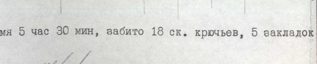
Departure to the route at 10:30, bivouac at 19:00, 8 climbing hours, 290 m covered, 42 rock pitons driven, 13 chocks. Sitting bivouac. Departure to the route at 8:00, bivouac at 18:00, 10 climbing hours, 110 m covered, 24 rock pitons driven, 4 bolt pitons, 9 chocks. Sitting bivouac. Departure to the route at 8:00, bivouac at 14:00 (snow, snowstorm), 6 climbing hours, 210 m covered, 23 rock pitons driven, 1 bolt, 12 chocks. Snow bivouac. Departure to the route at 9:00, summit at 14:30, climbing time 5 hours 30 minutes, 18 rock pitons driven, 5 chocks, 840-940 m covered.
| Date | Section | Avg. steepness, ° | Length, m | Terrain character | Diff. cat. | Condition | Weather conditions | Rock pitons | Ice pitons | Bolt pitons | Chocks |
|---|---|---|---|---|---|---|---|---|---|---|---|
| July 10, 1980 | R1 | 80 | 40 | Wall | 4-5 | partially destroyed | excellent | 3 | 3 | ||
| R2 | 90 | 40 | inner corner, chimney | 5-6 | — | — | 4 | 3 | |||
| R3 | 40 | 20 | ledge, gentle rock | 3 | destroyed | — | 2 | ||||
| R4 | 90 | 20 | wall with cracks | 5-6 | Monolith | — | 2 | 1 | |||
| R5 | 85 | 40 | inner corner | 6 | monolith | — | 4 | 1 | 1 | ||
| R6 | 75 | 40 | blind crack | 5-6 | — | — | 3 | 3 | |||
| R7 | 85 | 50 | wall with blind cracks | 5-6 | — | — | 2 | 11 | |||
| R8 | 90 | 30 | Inner corner | 6 | — | — | 3 | 1 | 1 | ||
| R9 | 85 | 20 | blind crack | 5-6 | — | — | 3 | 11 | |||
| R10 | 85 | 70 | wall | 6 | loose rock, monolith | — | 6 | 2 | 5 | ||
| R11 | 80 | 30 | cornice, inner corner | 5 | Monolith | — | 3 | 3 |
Departure to the route at 5:30. Arrival at bivouac at 19:00, 13.5 climbing hours. Sitting bivouac.
| Date | Section | Avg. steepness, ° | Length, m | Terrain character | Diff. cat. | Condition | Weather conditions | Rock pitons | Ice pitons | Bolt pitons | Chocks |
|---|---|---|---|---|---|---|---|---|---|---|---|
| July 11, 1980 | R12 | 90 | 50 | chimney | 7 | monolith | excellent | 2 | 1 | 3 | |
| R13 | 105 | 7 | wall | 6 | monolith | — | 1 | 1 | 1 | ||
| R14 | 60 | 30 | inner corner | 4 | destroyed | — | 2 | 2 | |||
| R15 | 85 | 30 | wall, chimney | 5 | monolith | — | 3 | 2 | |||
| R16 | 90 | 50 | wall | 6 | loose rock | — | 4 | 2 | |||
| R17 | 70 | 20 | wall | 4 | — | — | 1 | 1 | |||
| Arrival at the ridge of the eastern wall at 14:30. | |||||||||||
| R18 | 70 | 30 | descent into gap | loose rock | |||||||
| R19 | 60 | 40 | snow-ice couloir | 4 | — | 2 | 1 | ||||
| R20 | 60 | 200 | slab-like rock | 3 | destroyed | protection through ledges | |||||
| R21 | 60 | 150 | slabs with snow | 3-4 | — | ||||||
| R22 | 400-500 | ridge | 3 | destroyed | simultaneous movement | ||||||
| R23 | 75 | 80 | inner corner, wall | 5 | partially destroyed | 3 | 4 | ||||
| R24 | 60 | 150 | couloirs | 2 | — | simultaneous movement |
Departure from bivouac at 7:00, summit at 19:00, climbing hours - 11.5. Return to base camp at 21:15.
Brief explanation of the route characteristics table
To approach the route, it is necessary to cross a snow-ice couloir, which can be subject to rockfall at any time of day. The route begins with a characteristic "claw" with a vertical brown vein. Up the vein and then left of it to the top of the "claw", sections R1, R2.
ATTENTION! There are many loose rocks on the "claw" ledge.
Then, through the left of the overhanging cracks - a crack upwards into the inner corner and along it to a ledge that crosses almost the entire eastern wall. Sections R4, R5.
Through a system of blind cracks to the base of a vertical, overhanging inner corner, separating the slab from the wall massif. Very difficult climbing, loose rock, no cracks. Sections R6, R7.
The vertical inner corner is climbed using artificial aids on chocks. Section R8. And then section R9, similar to sections R6, R7. Exit to the slab.
On the slab, if necessary, it is possible to organize a sitting bivouac for 4 people. From this point, straight up through a small cornice to the grey wall, on which, 20 m above the slab, an inner corner with a blind end begins. Key point of the route. The rock is loose, with huge yellow "splashes"! All depressions are blind. Dangerous! It is difficult to organize reliable protection.
The cornice above the wall is passed on the right with entry into the inner corner and along it to a ledge for a bivouac for 4 people. Control cairn!
To the left of the bivouac, up a chimney and an overhanging wall with a crack. Climbing is extremely difficult. Section R12.
The wall, section R13, is climbed using artificial aids on pitons and chocks.
The most dangerous section of the route is R16. The rock crumbles, it is very difficult to organize protection, and it is very steep.
After exiting into the gap separating the ridge of the eastern wall from the main massif, the route proceeds in the direction of peak 4300 m, visible from below, from which a long ridge goes to the main summit. Descent along the way in the direction of peak Leningradets, 2 km traverse.
Brief description of the approach to the route
From the large talus in the upper reaches of the Archa-Kanysh river, along the right side of the large gravel field to the Kosh. From the Kosh, left across the bridge and along the left side of the river, and then up the slope to the left to a large snowy couloir descending from the pre-summit plateau of peak XXII Olympiad. To the left of the couloir, up the slope and then along the "ram's foreheads" under the cliffs, crossing the couloir to the base of the route. From the base camp to the talus 1.5 hours.


