ASCENT LOG
XXXI USSR Alpine Championship
-
Ascent class: rock climbing
-
Region of ascent, range: Pamir-Alai, Alai range.
-
Peak, height, ascent route: Peak 4300 m, height approximately 4500 m, via the left counterfort of the North face.
-
Proposed difficulty category: 5B cat. diff.
-
Route characteristics:
- Section lengths:
- 5A — 120 m
- 5B — 245 m
- 6 — 80 m
- Wall section: 810 m
- Sections 2–15: 245 m, average steepness 70°
- Total elevation gain: 1100 m
- Section lengths:
-
Pitons hammered in:
Category Rock Chocks Bolt Ice For belay 61 54 2 – For ETR 22 10 1 – -
Climbing hours: 20 h.
-
Number of bivouacs and their characteristics: One bivouac, lying down. Water available in the form of snow.
-
Group composition: 1. Kozlovsky N.A., Candidate Master of Sports, 2nd sports category; 2. Shklyaev E.V., Master of Sports of the USSR, 2nd sports category.
-
Coach of the team: Akhtyrsky O.A., Master of Sports of the USSR, 1st sports category.
-
Start of the route: July 10, 1980. Return: July 11, 1980.

-
Route of the Central Sports Club of the "Burevestnik" Sports Association team
-
Route of the CSKA team
TABLE OF MAIN ROUTE CHARACTERISTICS
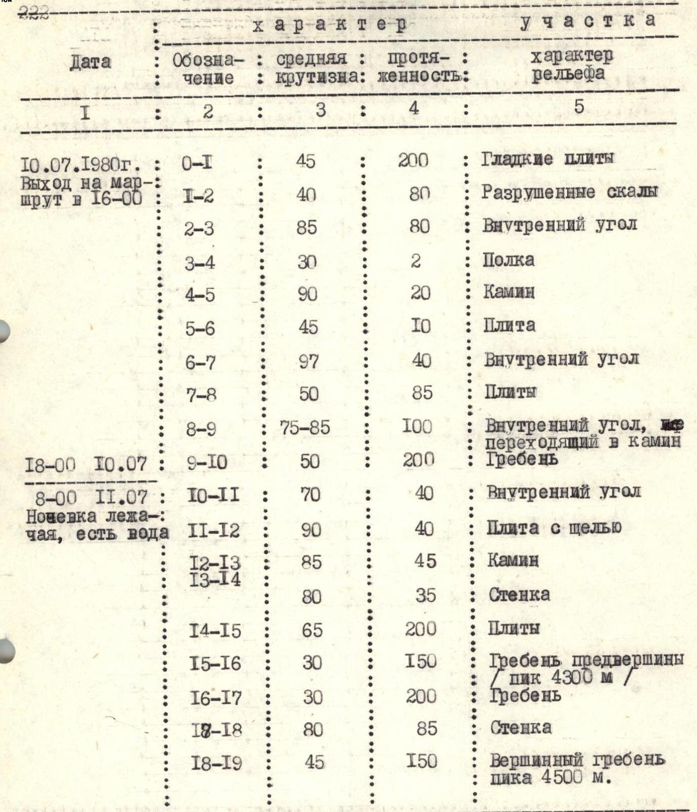
TABLE OF MAIN SECTION CHARACTERISTICS
| Date | Designation | Average steepness | Length | Terrain characteristics |
|---|---|---|---|---|
| July 10, 1980 | R0–R1 | 45° | 200 m | Smooth slabs |
| Departure at 16:00 | ||||
| R1–R2 | 40° | 80 m | Broken rocks | |
| R2–R3 | 85° | 80 m | Internal corner | |
| R3–R4 | 30° | 2 m | Ledge | |
| R4–R5 | 90° | 20 m | Chimney | |
| R5–R6 | 45° | 10 m | Slab | |
| R6–R7 | 97° | 40 m | Internal corner | |
| R7–R8 | 50° | 85 m | Slabs | |
| R8–R9 | 75–85° | 100 m | Internal corner turning into a chimney | |
| 18:00 July 10 | R9–R10 | 50° | 200 m | Ridge |
| 8:00 July 11 | R10–R11 | 70° | 40 m | Internal corner |
| Lying bivouac, water available | ||||
| R11–R12 | 90° | 40 m | Slab with a crack | |
| R12–R13 | 85° | 45 m | Chimney | |
| R13–R14 | 80° | 35 m | Wall | |
| R14–R15 | 65° | 200 m | Slabs | |
| R15–R16 | 30° | 150 m | Ridge of the subpeak (Peak 4300 m) | |
| R16–R17 | 30° | 200 m | Ridge | |
| R17–R18 | 80° | 85 m | Wall | |
| R18–R19 | 45° | 150 m | Summit ridge of Peak 4500 m |
Route Characteristics: Pitons
| Difficulty | Section condition | Weather conditions | Rock | Chocks | Ice | Bolt |
|---|---|---|---|---|---|---|
| 3B | Very smooth | Good | 2 | – | – | – |
| 3B | Broken | «» | 2 | – | – | – |
| 5B | Monolithic | 10+2 | 2+3 | – | – | |
| For two people | 2 | 1 | – | – | ||
| 5A | Beginning overhangs | 2 | – | – | – | |
| 4B | Monolithic | 2 | – | – | – | |
| 6 | Crumbly | 3+4 | 2+3 | – | 1+1 | |
| 4A | Monolithic | 2 | 1 | – | – | |
| 5A | Crumbly | 5+2 | 4 | – | – | |
| 3B | Broken | 2 | 4 | – | – | |
| 4B | With "live" blocks | 3 | 2 | – | – | |
| 6 | Monolithic | 3+8 | 2+2 | – | 1 | |
| 5B | Large overhang at the start | 6+3 | 4+2 | – | – | |
| 5B | Crumbly | 4+1 | 3 | – | – | |
| 4B | Monolithic | 10 | 8 | – | – | |
| 4A | Snow, slushy, rocks | 2 | 1 | – | – | |
| 3A | Broken | 1 | 5 | – | – | |
| 5B | Upper part icy | 4+2 | 5 | – | – | |
| 3B | Broken rocks | – | 6 | – | – |
EXPLANATIONS FOR THE TABLE OF MAIN ROUTE CHARACTERISTICS
R0–R1. Gentle, very smooth slabs with few cracks and holds.
R1–R2. Broken rocks with ledges.
R2–R3. Steep internal corner. The first five meters are heavily broken. The first 40 m lead to a large overhang. Belay can be organized to the left of the overhang on a narrow ledge for one person. The overhang is passed directly through a narrow crack using ETR. Above the overhang — through the internal corner. Climbing is very difficult. Climbing and belaying are further complicated by the characteristic structure of the rocks forming the entire massif — crumbly crystalline debris. The internal corner leads to a good ledge (section R3–R4), where two people can stand.
R4–R5. Steep chimney to the left of the ledge with very smooth walls. Passed with difficult climbing. The chimney leads to a smooth slab (section R5–R6). Across the slab, 10 m — traverse right to the base of a 40-meter internal corner.
R6–R7. This is one of the key locations on the route. Passed using ETR, only in the upper part, where the internal corner turns into a wide overhanging crack, was it possible to climb. The crack leads to a convenient ledge for belaying.
R7–R9. Then across the slabs to the left under a wide internal corner. Up the corner 40 m to the base of a chimney with an overhanging plug. The plug can be passed along its left edge and then up the chimney — exit to the ridge.
R9–R10. The ridge is heavily broken, passed on the right side. Leads directly to a good bivouac site just below the wall of the upper bastion.
R10–R11. From the bivouac, slightly to the left and up the internal corner 40 m, under a steep overhanging slab.
R11–R12. One of the key locations on the route. Steep overhanging slab with a narrow blind crack. Passed partly using ETR, partly with difficult climbing. Ends with a good ledge.
R12–R13. Initially 10 m up a steep but fairly straightforward internal corner — onto a slab under a significantly overhanging chimney. To the left of the chimney, one can climb up a 15-meter crevice to its end and from there, with a wide pendulum, enter the chimney, bypassing the overhang.
R13–R14. The chimney leads to a narrow ledge under a heavily broken wall. Up the wall 40 m straight up onto gentle slabs. Climbing the slabs (section R14–R15) is hindered by the small number of holds and the cat-like structure of the rocks.
R15–R16. The slabs lead to the base of a huge "Finger gendarme" on the ridge of the subpeak (Peak 4300 m). The ascent to the subpeak is to the right of the ridge, traversing steep snowfields.
R16–R17. From the subpeak, the main peak of the massif — Peak 4500 m — is visible in the distance. Along a narrow, heavily broken ridge. "Gendarmes" on the ridge are mostly bypassed on the left as you go.
R17–R18. The ridge abuts a steep 80-meter wall. Under the wall in a depression — a good bivouac site. The wall:
- is initially passed straight up — 30 m;
- then 10 m — traverse right along a narrow ledge;
- and 40 m — up an icy internal corner. Exit onto the summit ridge.
R18–R19. Exit to the summit to the left along the summit ridge. Rocks are partly heavily broken.
Descent from the summit along the East Ridge to a wide scree-filled couloir and down it — descent into the northern cirque of Peak Leningradets. And then along the trail to the base camp. Descent takes 5–6 hours.
Time breakdown:
- Day 1. Departure at 5:00. Arrival at the bivouac under the second bastion at 18:00.
- Day 2. Start of the ascent of the second bastion at 8:00. Arrival at the subpeak (Peak 4300 m) at 15:00. Arrival at the summit at 20:00. Return to the base camp of the XXXI USSR Alpine Championship at 23:00.

