Climbing type — rock Climbing area — Alai ridge, Dugoба resort area Peak, its height — Gandakush 3850 m Ascent route — NW edge Proposed category of difficulty — 3B Route characteristics — rock Height difference — 3100–3850 m = 750 m Length of sections with 5–6 category of difficulty — none Steepness — 40–44° Number of driven hooks for belay:
- rock — 18 pcs.
- ice — none
- bolted — none Number of walking hours — 7 hours Leader's name, number of participants and their sports qualification — Kamenev Yu.I. + 5 people (sports rank) Team's sports reserve — Lukashevich G.A. (sports rank) Date of departure on the route and ascent — August 31, 1979
Gandakush
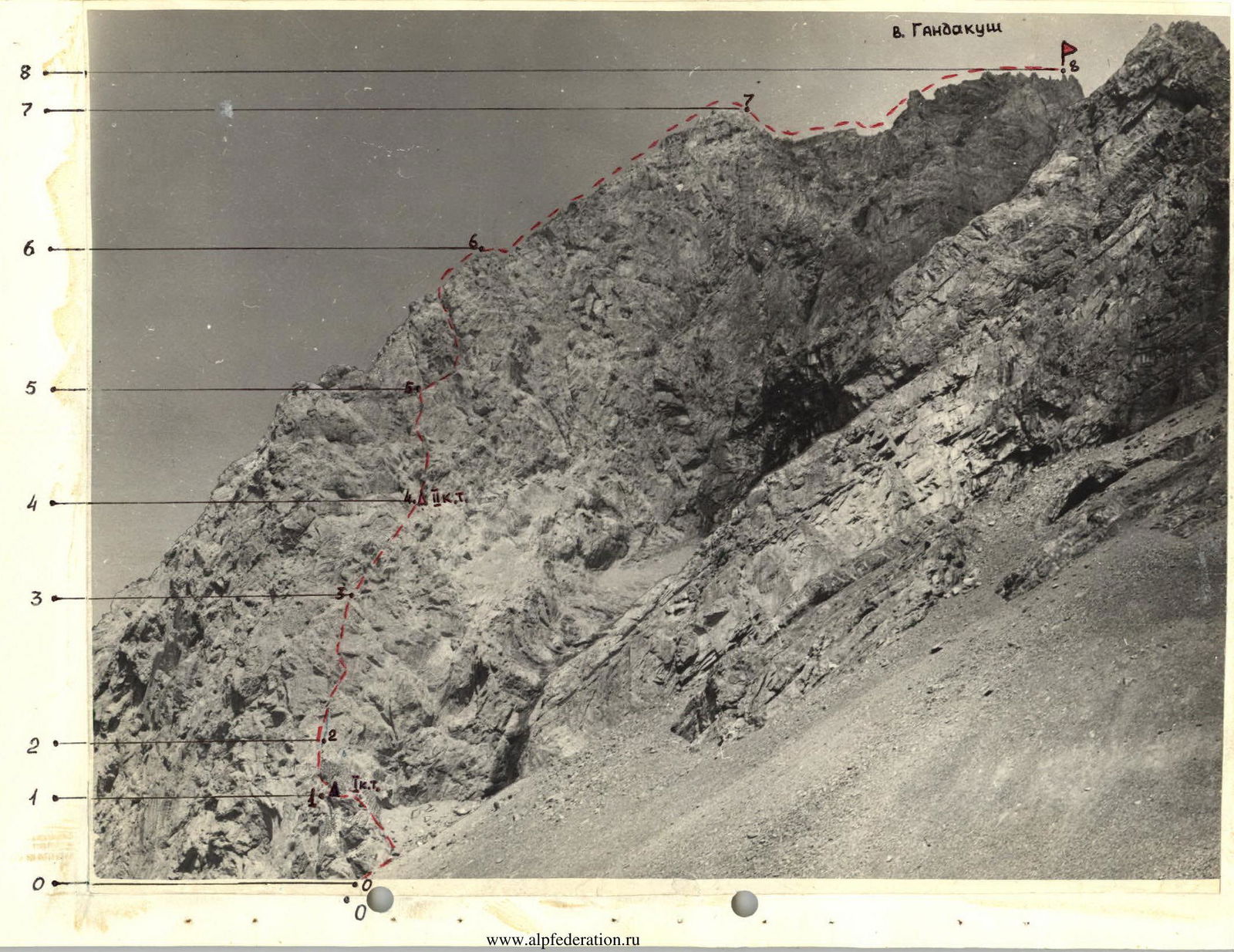
| Section | Average steepness | Length, m | Relief characteristics | Category of difficulty | State | Weather conditions | Rock hooks (belay) | Ice | Bolted |
|---|---|---|---|---|---|---|---|---|---|
| R0–R1 | 20° | 270 | couloir, crack | 1 | large blocks, small scree, monolithic rocks | good | simultaneous | – | – |
| R1–R2 | 60–70° | 40 | wall, crack | 4 | destroyed rocks, scree shelf | good | 4 | – | – |
| R2–R3 | 50° | 90 | chimney, shelf | 3 | destroyed rocks, monolithic rocks | good | 3 (alternating) | – | – |
| R3–R4 | 60° | 85 | wall, shelf, ledges | 4 | monolithic rocks, small scree, destroyed rocks | good | 3 (ledges) | – | – |
| R4–R5 | 45° | 70 | shelf, wide crack, edge | 3 | monolithic rocks, destroyed rocks | good | 2 | – | – |
| R5–R6 | 60° | 95 | edge, chimney with corks, scree shelves | 4 | monolithic rocks, destroyed rocks, small scree | good | 6 | – | – |
| R6–R7 | 25° | 160 | ridge | 2 | destroyed ridge, scree | good | alternating, simultaneous | – | – |
| R7–R8 | 25° | 250 | ridge | 1 | heavily destroyed rocks, scree | good | simultaneous | – | – |
(Short explanation of the table)
From Dugoба resort, we ascend along the left orographic bank of the Dugoба river to the confluence of the Dugoба and Ulitor rivers, cross the bridge to the Ulitor river and ascend to the "Edelweiss glade" bivouac. After the glade, we follow the left bank to the first canyon in the Ulitor gorge. Beyond the canyon, we cross the Ulitor river to a wide couloir with a riverbed. In the lower part of the couloir, there is compacted large-block scree, which leads to the first rocks. Two ropes of rocks (climbing is not difficult, belay via ledges) through a wide crack lead to a shelf. First control point (270 m). From the first control point, we approach the wall. The wall is 20 m (climbing is difficult, hook belay — 4 hooks). The rocks are destroyed. Through a wide crack, we emerge onto a platform (40 m). From the platform, straight up, there is a wide chimney 10 m (climbing is not difficult, belay with hooks — 2 hooks), which leads to an inclined shelf. From the shelf, across destroyed rocks (alternating belay), we emerge onto a horizontal scree shelf under the black wall (95 m). From the shelf, up and to the right across the black wall 15 m with a niche in the right part (climbing is difficult, belay with hooks — 3 hooks). Further along the inclined shelf and destroyed rocks (alternating belay), we emerge onto a scree shelf under the red wall. Second control point. From the second control point, along the shelf to the left 10 m and up through a wide crack 30 m (belay with hooks — 2 hooks), we emerge onto an edge (70 m). The edge is traversed on the right. A rope of rocks of moderate difficulty (belay with hooks — 2 hooks; via ledges) leads to a chimney with corks in the upper part. The chimney is 30 m, passed with hook belay, climbing is difficult, rocks are monolithic — 4 hooks. The chimney leads to a destroyed ridge (90 m). Along the ridge, 4 ropes of easy destroyed rocks (alternating and simultaneous belay) lead to a destroyed ridge, turning into a scree one. The scree is dense, compacted. Along the scree ridge, we emerge under heavily destroyed pre-summit rocks, which are bypassed on the right (simultaneous belay). Descent via the 3A category of difficulty route.
Recommendations
Departure from "Edelweiss glade" at 4–5 am. Shoes with a rubber protector, 8–10 rock hooks.
Group composition:
- 4–6 people.
Group leader:
- Kauf
- Kamenev


