Ascent Passport
- Climbing category — technical.
- Pamir-Alay, mountain range.
- Gandakush peak, 4300 m, via the eastern spur.
- Complexity category 3B–4A.
- Height difference 8500 m, average steepness 45°–49°.
- 8 rock pitons hammered in for belaying.
- Total climbing time — 8 hours.
- Overnight stay (earthen platform) under the route in the Ular-Sai gorge, on the bank of the Ular-Sai river.
- Team leader — Osminin Vladimir Alekseevich — 1st sports category. Team members: Andrienko Valery Pavlovich — 1st sports category, Moiseev Yuri Mikhailovich — 1st sports category, Sokolovsky Evgeny Alekseevich — 1st sports category, Fedotov Viktor Aleksandrovich — 1st sports category.
- Team coach: Yakovlev Valery Dmitrievich — Master of Sports.
- Departure to the route — September 17. Return — September 17.
Route Description
to Gandakush peak via the eastern spur, 3B–4A category (approximate)
From "Dugoba" tourist center up the Dugoba gorge to its confluence with Ulitor gorge, then to Gandakush pass. From the pass, descend straight down the scree into Ular-Sai gorge. Overnight stay. From the camp to overnight stay — 4–5 hours.
From the overnight stay, left (orographically) up into a wide scree-filled couloir between two gentle ridges of the eastern spur. Ascend the couloir on its left side to the distinct "Red Wall". 35–40 m before the "Red Wall", exit onto the gentle left ridge — R0 — this is the start of the route.
On the right side of the ridge, via a faint ledge 8 m and a 5-meter wall, across smoothed rocks (steepness 45°–40°) resembling sheep's backs — exit onto the ridge. Then, on the left side of the ridge, 40 m up to the base of a gendarme. Here is a wide scree-filled col. From the start of the route to the col — two rope lengths (section R1).
The gendarme is bypassed on the left for 20 m, and 30 m up monolithic smooth slabs (difficult climbing). On the gendarme — a control cairn. From the gendarme 20 m along the ridge and left up a steep, destroyed inner corner 50 m. Piton belay. ("Live" rocks. Section R2).
On the left side of the ridge along a scree-filled ledge to the base of the second gendarme (40 m).
Bypass the gendarme on the right via an inclined (60°) chimney 10 m ("Live rocks"!), across simple rocks and an inclined inner corner.
Then:
- 40 m along the ledge;
- 30 m up the inner corner;
- up rocks of medium difficulty 40 m — exit onto the ridge with variable belay.
Further:
- across not steep, destroyed rocks 100 m;
- exit onto a gendarme via a 25 m chimney (piton belay) (section R3).
Control cairn.
Ascend along the ridge 40 m, then up the inner corner 30 m (piton belay) to the base of the pre-summit tower. On the right side, left up 120 m. Then a 3-meter chimney with a plug and exit onto the ridge (section R4).
Along the destroyed, simple ridge 120 m to the pre-summit slope. From the ridge to the summit 150 m (section R5).
Descent along the northern ridge to Gandakush pass via a 3A category route.
Time schedule for the first ascent group:
- 15:00 — departure from camp.
- 16:00 — confluence of Gandakush and Dugoba gorges.
- 17:20 — Edelweiss glade.
- 18:30 — Gandakush pass.
- 19:10 — overnight stay under the eastern spur.
Second day:
- 6:00 — ascent.
- 7:00 — start of the route.
- 7:50 — approach to the wide scree-filled couloir under the "Red Wall", start of technical climbing.
To the summit — 6–8 hours. Descent to Gandakush pass takes 1.5–2 hours. Then — return to camp.
Recommendations:
- Group: 4 people.
- Rope: 30–40 m, 2 pieces.
- Hammers: 2 pieces.
- Ice axes: 2 pieces.
- Rock pitons: 10–12 pieces.
- Helmets: 4 pieces.
- Footwear: Vibram soles recommended.
| Section | Average steepness | Length | Character of the section | Difficulty | Condition | Weather conditions | Belay (rock pitons) | Passage |
|---|---|---|---|---|---|---|---|---|
| R1 | 35°–40° | 80 m | Ledge, wall, ridge | II–III | Destroyed rocks | Good | Protrusions, simultaneous | Simultaneous movement, free climbing |
| R2 | 45°–50° | 120 m | Smooth slab, inner corner | III–IV | Monolith, destroyed rocks | Good | Protrusions, 3 pitons | Free climbing |
| R3 | 45°–50° | 390 m | Inner corners, ledges, slope | III | Destroyed rocks, snow-covered | Good | Protrusions, 3 pitons, simultaneous | Simultaneous movement, free climbing |
| R4 | 40°–45° | 200 m | Inner corner, ridge, slope | III–IV | Destroyed rocks, snow-covered | Good | Protrusions, 4 pitons | Simultaneous movement, free climbing |
| R5 | 30°–35° | 270 m | Ridge, slope | II | Destroyed rocks, slope | Good | Protrusions, simultaneous | Simultaneous climbing |
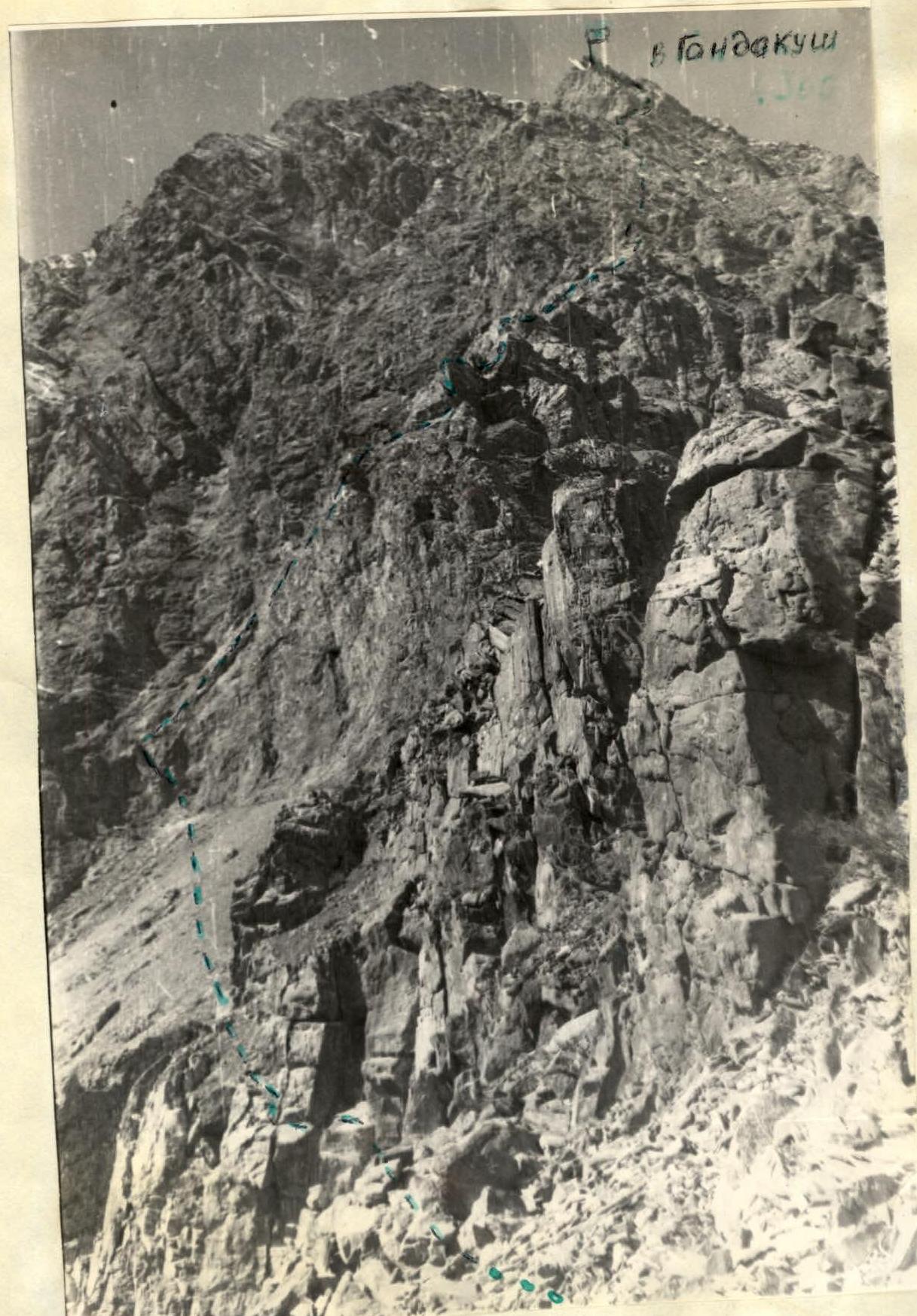
 Photo #1: General view of the route
Approach to Gandakush peak
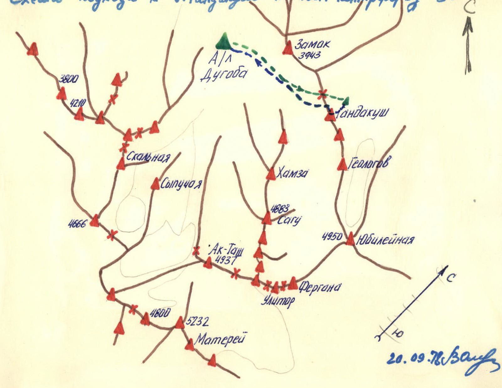 Approach to Gandakush peak via the eastern spur, 3B category.
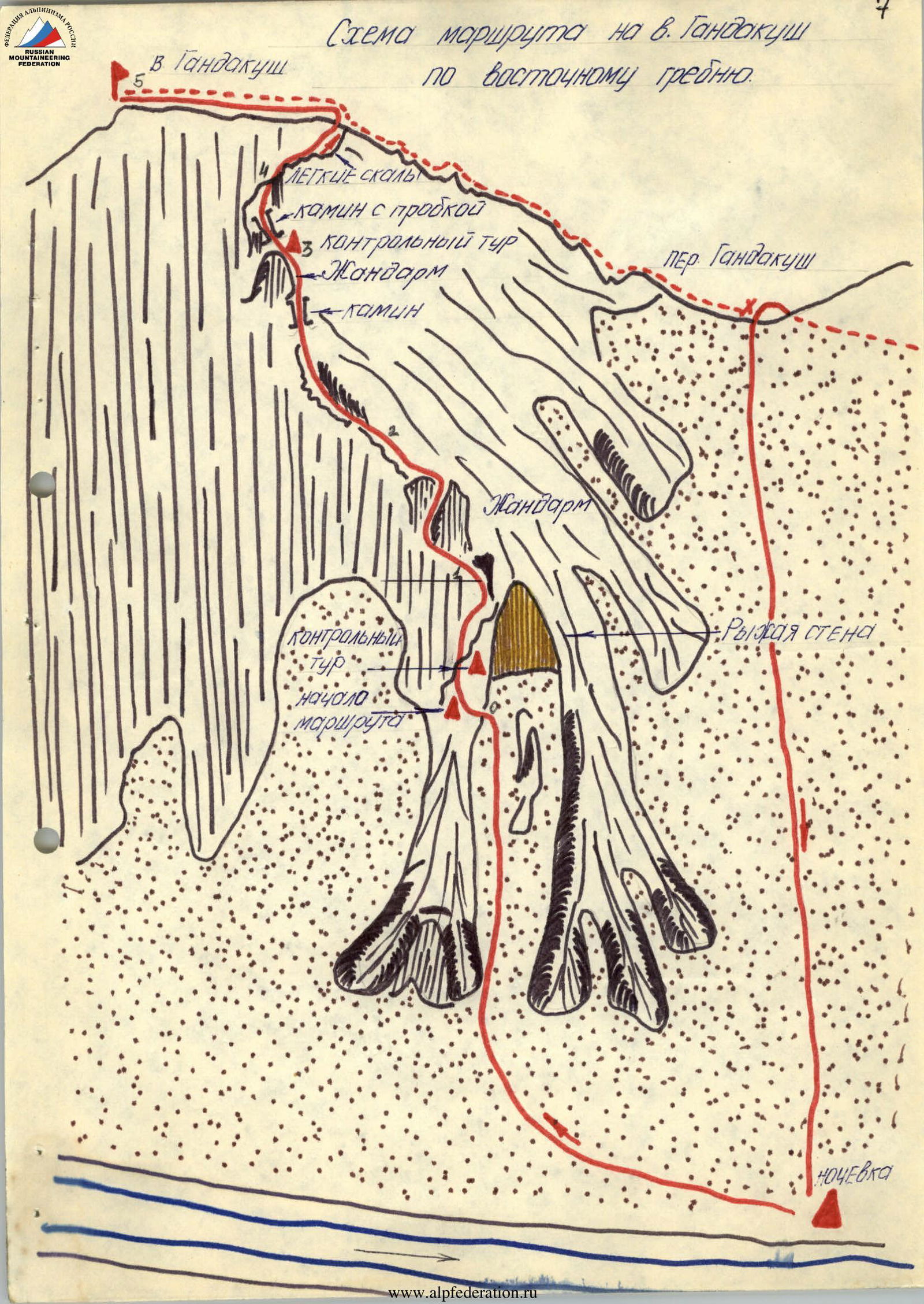 Route diagram to Gandakush peak via the eastern ridge.
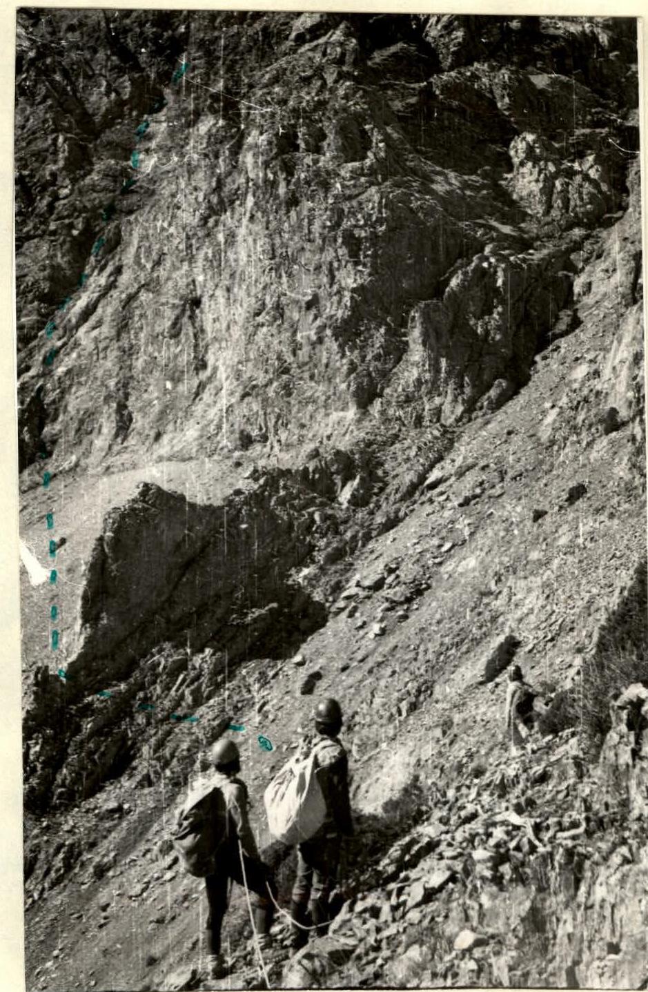 Photo #2: "Red Wall".
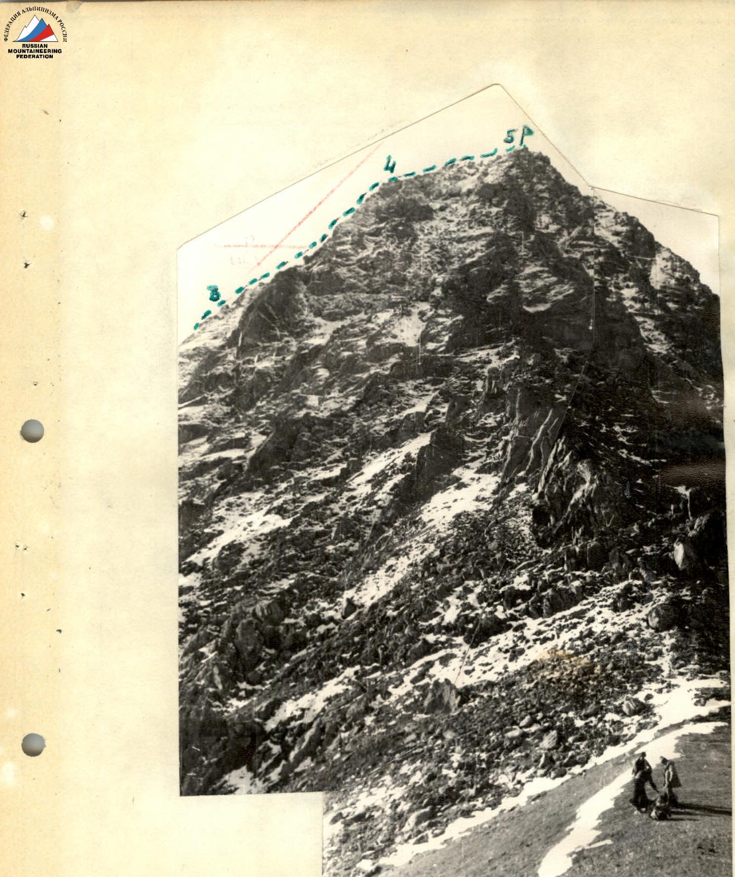 Photo #7: General view of the summit from Gandakush pass and the upper part of the route.


