ASCENT LOG
I. Technical Class
-
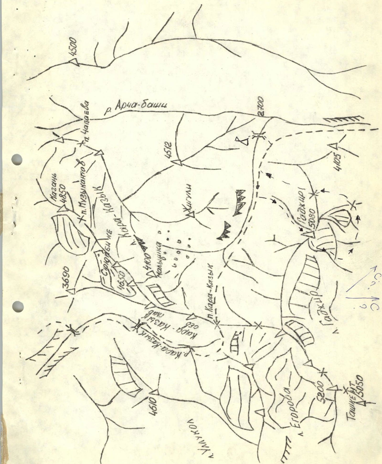
Ascent Area: Pamir-Alay, Alayskiy Ridge
-
Peak Gajir (5080 m), via the South-East Face and South-West Ridge
-
5B category of complexity
-
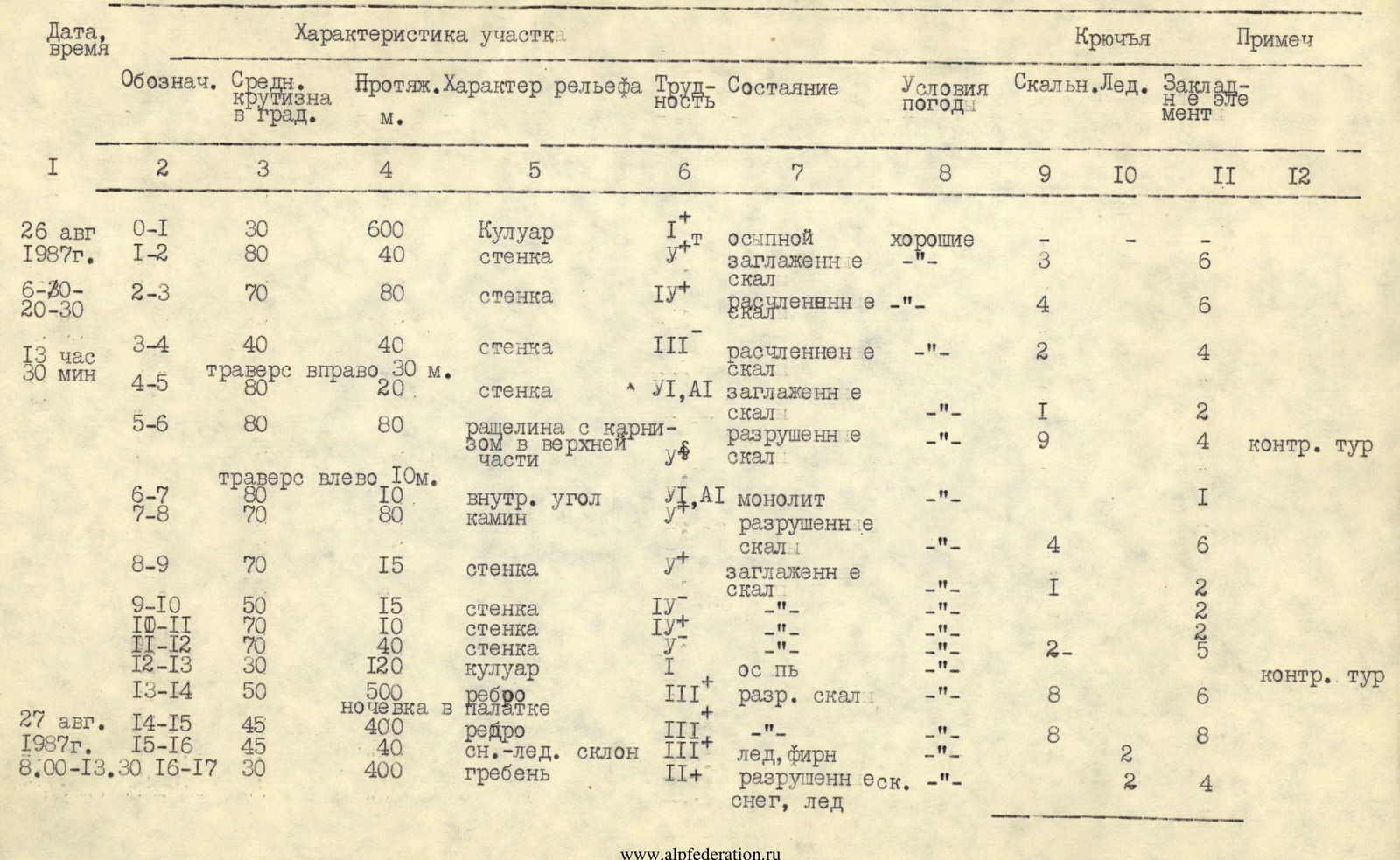
Route Characteristics: height difference – 2000 m, average steepness – 60°, face steepness – 70°, total length – 2600 m, length of sections with 5th category of complexity – 300 m, length of sections with 6th category of complexity – 30 m
-
Pitons used: rock – 42, ice – 4, protection gear – 56, for creating Intermediate Technical Objects (ITO) – 2
-
Total climbing hours: 19
-
Number of nights spent: one overnight stay in a tent
-
Surname, first name, patronymic of the team leader, participants, and their qualification: Danilov Vladimir Nikolaevich — 1st sports category, team captain Belous Sergey Stepanovich — 1st sports category, participant Boytsov Dmitry Anatolyevich — 1st sports category, participant Mezhevich Sergey Alekseevich — 1st sports category, participant Nikolaev Viktor Kornilovich — Candidate Master of Sports, participant Filippov Mikhail Nikolaevich — 1st sports category, participant
-
Team Coach: Filippov Mikhail Nikolaevich
-
Date of departure for the route: August 26, 1987 Date of return: August 27, 1987
-
Organization: branch of AUS B "Dugoba", Kara-Kazyk.
Peak Gajir

Ascent Area Map
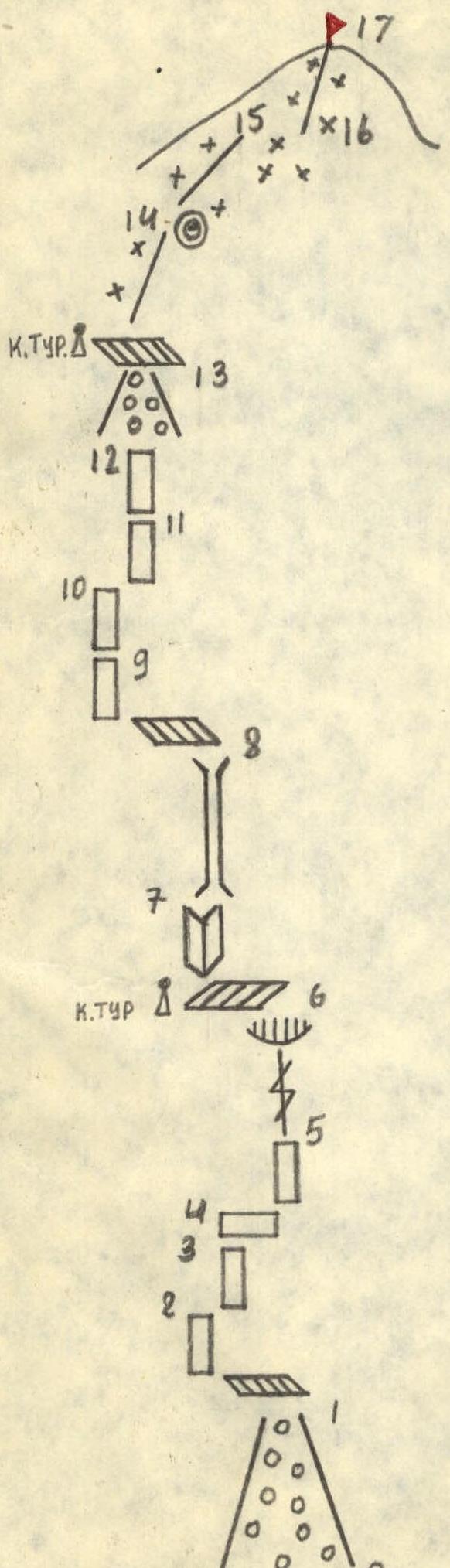
Route Diagram
2. Team Preparation for the Ascent
The Kara-Kazyk valley has been actively explored by climbers over the last two years. With the base camp located at the junction of the Kara-Kazyk and Archa-Bashi valleys, Peak Gajir stands as the central peak of the area.
We were drawn to the route via the South-East Face and South-West Ridge due to its logical progression. Training ascents for team members were planned and executed to thoroughly study the path of the future ascent and descent. On August 19, Mezhevich S.A., Belous S.S., and Boytsov D.A., as part of a group, ascended Peak Gajir via the North Ridge following a 4A category route and familiarized themselves in detail with the descent from the summit. Danilov V.N. and Filippov M.N. completed an ascent of Peak Dostuk (AlauDin) via a 5B category route and reviewed the ascent profile. Such preparation was necessitated by the lack of a first ascent report.
3. Tactical Ascent Plan
Based on reconnaissance, observations of the route, and incomplete information about the first ascent by Bello's team, it was planned to complete the route in 2–3 days:
Day 1 — traverse the face and reach the South-West Ridge. Day 2 — ascend the South-West Ridge, reach the summit, and descend to the base camp. Day 3 — reserve day.
Given that the ascent would demand significant physical and mental effort, considerable attention was devoted to evenly distributing the workload among team members, achieved through the proper allocation of responsibilities.
The overall group movement tactic was as follows:
- A rope team consistently worked at the front.
- A trio ensured a smooth supply of gear to those ahead.
Radio communication with the base camp was conducted regularly during designated radio hours using "Kaktus" radios.
4. Brief Description of the Route Ascent
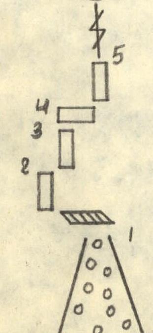
On August 26, 1987, the team departed the base camp towards the route. The approach took 1.5 hours along the road and 1 hour upwards from the road to the route via a simple scree couloir (R0–R1). Weather conditions were good, and it was warm.
The team worked as follows:
- Danilov V.N. — Belous S.S. rope team led.
- Filippov M.N. — Mezhevich S.A. — Boytsov D.A. followed.
The climb immediately became challenging, with few handholds. However, the rock was dry, and climbing shoes provided good friction (R1–R2). After completing a rope length, a good belay stance was found on a ledge, allowing the team to potentially gather if needed.
The next 120 m involved traversing inclined slabs of III–IV category difficulty with numerous handholds and good belay points. Mainly protection gear was used (R2–R3, R3–R4).
After traversing 20–30 m to the right, the team encountered very difficult climbing on a steep slab transitioning into a crevice. The crevice was capped with an overhanging cornice. The slab was climbed using one ITO (R4–R5). Climbing the crevice was strenuous, with piton and protection gear belays. The cornice required great caution due to its fragile state, making it difficult to bypass on either side. Belay stances were uncomfortable, with belays taken from a "harness" in a seated position (R5–R6).
Following the R5–R6 section, the team reached a large horizontal ledge where a control cairn was established. Moving 10 m left along the ledge led to a 10-meter internal corner with virtually no handholds. The internal corner was climbed using one ITO (R6–R7).
Further on:
- A challenging chimney filled with loose rocks required careful navigation.
- Belay stances were limited to accommodating no more than two people.
- Belays were taken from a seated position in a "harness."
The chimney led to an inclined, scree-covered ledge. From the left part of the ledge, the team ascended a 15-meter smooth slab. The climbing was challenging (R8–R9).
Two rope lengths of vertical slabs led to a wide, scree-filled couloir. The climbing was of medium to above medium difficulty (R9–R12). Belay stances were comfortable.
A straightforward ascent up the wide couloir led to the shoulder of the SW ridge. A second control cairn was established (R12–R13). The team then ascended 500 m up the SW ridge's moderately difficult rock to a snow tongue, where they set up a safe overnight camp in a tent at 20:00.
On August 27, it was cold and clear. The team rose at 6:30 and began moving at 8:00. They quickly covered 400 m on the SW ridge, where the rock was of moderate difficulty and the path was straightforward (R14–R15). Some sections had verglas on the rocks, and short, challenging walls were encountered. Movement was mostly simultaneous. The SW ridge then deviated left. The team transitioned across ice to the right onto a rock outcrop, using an ice screw for protection (R15–R16). They ascended to the right up moderately difficult rock, with some snow and ice, towards a snow saddle on the pre-summit ridge and then followed the straightforward ridge (with cornices!) to the summit. Movement along the ridge was simultaneous. At 13:30, they reached the summit. The descent via the previously known route took 3 hours. By 17:00, they were on the moraine beneath the glacier, and after another 3 hours, they returned to the base camp.
The team utilized their full range of pitons and all available protection gear during the ascent. Quickdraws made from nylon webbing proved very useful, as the nature of the route's wall section made rope dragging through carabiners challenging.
The description was compiled by the team leader: V.N. Danilov
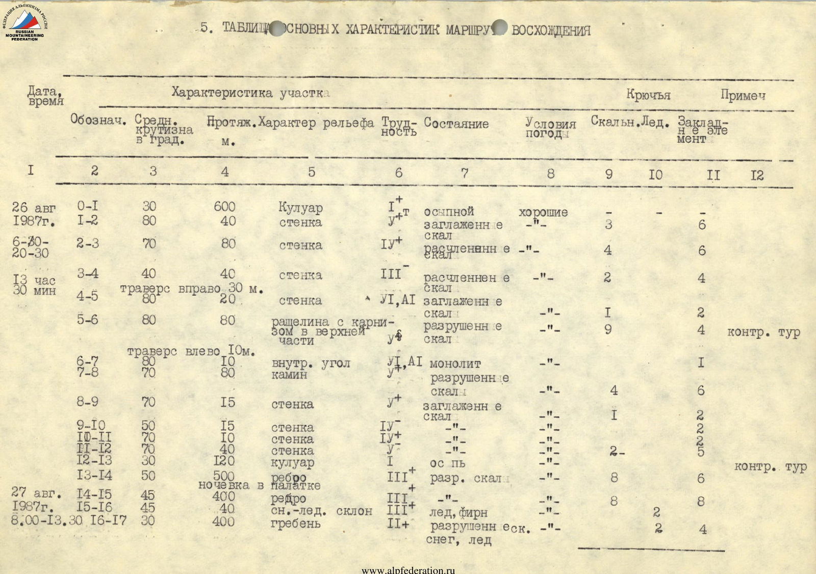
5. Table of Main Ascent Route Characteristics
The table of main ascent route characteristics is on page 8.
6. Ascent Debriefing Protocol
August 28, 1987, Kara-Kazyk valley. The second ascent of Peak Gajir via the South-East Face and SW Ridge, 5B category of complexity, was approximately completed by a team in the following composition:
- Danilov V.N. — team captain, 1st sports category
- Belous S.S. — participant, 1st sports category
- Mezhevich S.A. — participant, 1st sports category
- Nikolaev V.K. — participant, Candidate Master of Sports
- Boytsov D.A. — participant, 1st sports category
- Filippov M.N. — participant, 1st sports category
Those present at the debriefing included:
- The entire team;
- Head of the USSR MS training camp, Matveyenko V.A.;
- Head of rescue operations, USSR MS, Semenov A.N.
Danilov V.N.: Preliminarily assessing the route, we can say that the height difference is 2000 m, the route length is about 2600 m, and the wall's steepness is around 70°. We rate the route as 5B category of complexity. The tactical plan was based on ascents on Peak Gajir via a 4A category route and Peak Dostuk via a 5B category route, along with incomplete information about the first ascent. The team fully executed the tactical plan within the set timeframe.
On August 26, we traversed the wall section — 14 rope lengths — and reached the shoulder of the SW ridge, then ascended the ridge's rock to the overnight camp site. On August 27, we continued, reaching the summit at 13:30, replaced the note, and began our descent.
The Danilov V.N. — Belous S.S. rope team worked at the front, acting confidently and clearly, establishing reliable belay points. All challenging rope lengths were completed on fixed ropes using ascenders.
Mezhevich S.A. frequently worked last, with no criticisms or delays in passing ropes and pitons.
The team descended via the 4A category route previously completed by three team members.
Compared to previously climbed 5A category routes, this route is significantly more challenging. Compared to the previously climbed 5B category route on Peak Dostuk, this route is somewhat more challenging and longer in terms of both complex rope lengths and total length.
I am familiar with the participants. For the second year, we have been undertaking ascents of the 5th category of complexity.
Semenov A.N.: "How much time was spent on completing one rope length by the first climber?"
Danilov V.N.: "It varied with complexity. On average, between 15 to 30 minutes on the wall section."
Matveyenko V.A.: "How was the load distributed within the group?"
Danilov V.N.: "The first climber worked with a light rucksack. The others carried rucksacks weighing an average of 10–12 kg."
Filippov M.N.: "Everything was thoroughly planned before starting the route, including gear and food selection. The route is very diverse in terms of terrain and climbing technique. The entire range of pitons and protection gear was used. The effort was correctly distributed throughout the route. All participants know each other well. Working in a well-coordinated team is easy. I believe the captain fully accomplished his task."
Mezhevich S.A.: "I am very satisfied with the ascent. The route is challenging. Handholds are small, and there are few cracks for piton placement; nonetheless, belay points were very reliable."
Matveyenko V.A.: "Describe the overnight camp."
Mezhevich S.A.: "The camp was in a tent on a comfortable site. The site was slightly leveled. There is enough space for two tents. A snow tongue is nearby."
Belous S.S.: "The team maintained friendly relations, with each member knowing their role and performing it without reminders from the captain. A lot of time was dedicated to safety. We enjoyed the route — it's challenging and logical."
Semenov A.N.: "Was communication with the base camp stable?"
Danilov V.N.: "Yes, radio communication was conducted three times a day. There was no communication on August 27, 1987, between 16:00–17:00 due to a lack of direct visibility with the base camp. The 'Kaktus' radio station is reliable and convenient to operate."
Semenov A.N.: "It can be concluded that the 5B category route was climbed very reliably, in line with the tactical plan. The team successfully accomplished its tasks."
Matveyenko V.A.: "From the leader's and participants' accounts, it's clear that the route is undoubtedly 5B category. The team fully accomplished its tasks. I recommend compiling an ascent report as soon as possible. The leader's guidance and participants' involvement should be credited."
Head of the training department, AUS B "Dugoba" Kara-Kazyk branch, Matveyenko V.A.
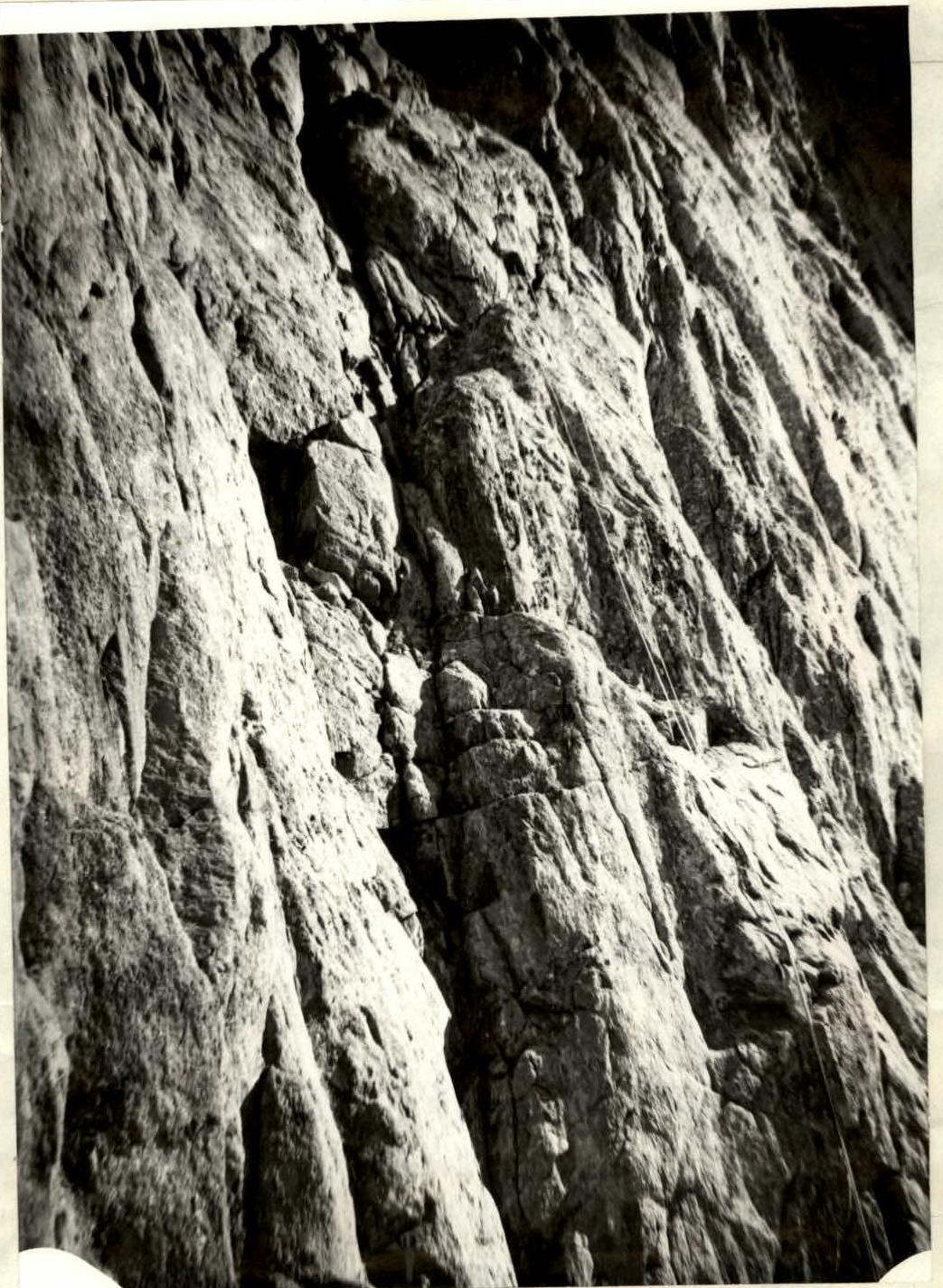 point (R5–R6)