Ascent Passport
I. Ascent class: technical
2. Ascent area: Pamiro-Alai: Kara-Kazyk gorge
3. Peak, its height, ascent route, route character: peak Gadjir, 5050 m, SW ridge, combined
4. Proposed difficulty category: 5B
5. Route characteristics:
* elevation gain 1700 m
* length of sections 5–6 km/tr. 550 m
* average steepness up to R13: 75°–80°
* after R13: 30°–35°
6. Pitons driven: 103/6
* number of chocks used: 30 pcs.
7. Number of climbing hours: 22 (including processing)
8. Number of bivouacs and their characteristics: one, good
9. Surname, name, patronymic of the leader, participants, their qualification:
Korenyugin I.K. — CMS, leader; Novikov V.T. — CMS, participant; Meshcheryakov V.E. — CMS, participant; Kamenev V.N. — 1st sports category, participant
10. Team coach: Zaev E.F., Master of Sports of the USSR
11. Date of departure and return: July 22, 1987 – July 24, 1987
12. Organization: branch of a/b Dugoba in Kara-Kazyk gorge.
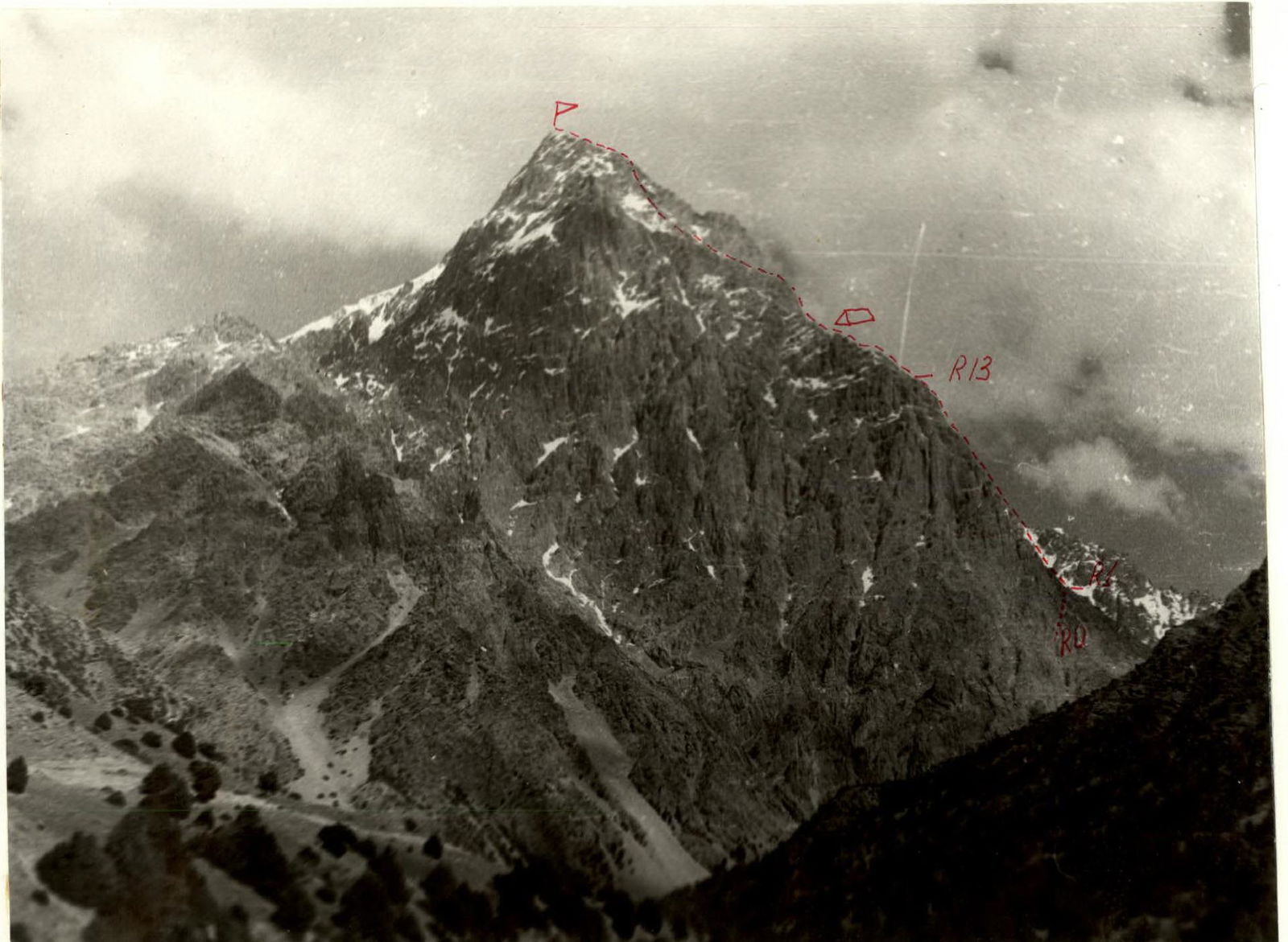
Brief description of the approach
From the base camp at the confluence of the Archa-Bashi and Kara-Kazyk rivers along the road up to the ridge descending to peak Gadjir, in the Kara-Kazyk gorge. Then left up along the ridge, leaving it on the left, first on the scree, then on the scree couloir 1.5 hours.
The landmark for the start of the route is the second rock "gate" on the left. Enter these "gates" and left to a short couloir-chimney 2nd category of difficulty. The chimney leads to a good site.
Brief explanation of the diagram
The proposed route is logical. It can be conditionally divided into two parts: up to R13 — the steepest part of the route, 500 m. Varied rock terrain is mostly passed by free climbing. The rocks are dry, warm, and the footwear holds well.
Various pitons and chocks (stoppers) were used; on average, 7-9 pitons per rope length.
In the first part of the route, in 3-4 places, a sitting bivouac is possible. A comfortable bivouac is only after R13.
Sections up to R7 were processed in advance, which made it possible to bivouac in good conditions. Up to R11 there is no water. From R14 the path can be ambiguous, but generally near the ridge.
Descent into the Gadjir gorge along route 4A category of difficulty and through two scree passes to the base camp took 7-8 hours.
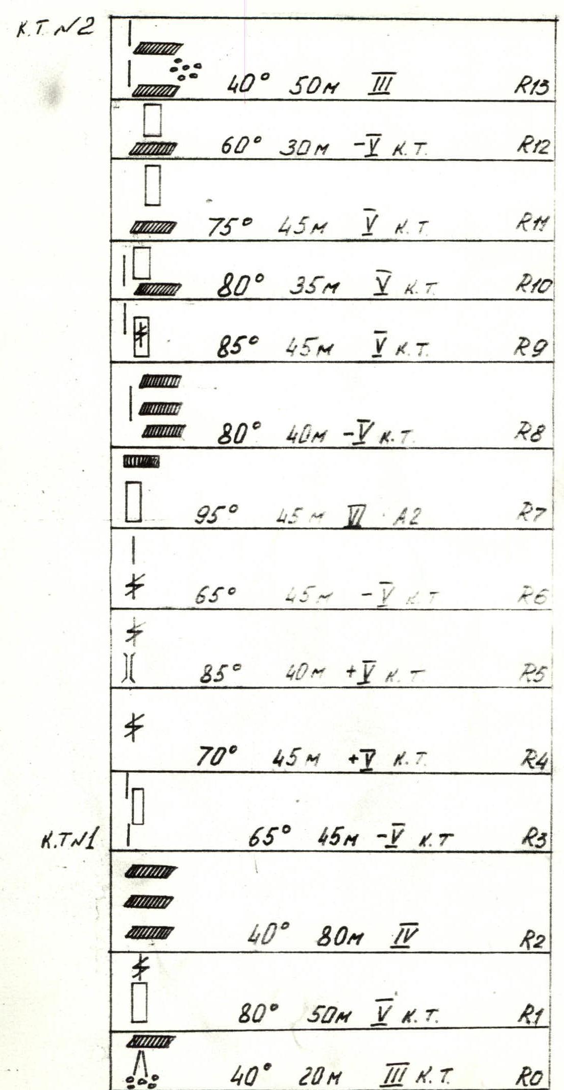
Route diagram in symbols
Route diagram in symbols (continued)
Route diagram in symbols (continued)
C.T. #2
- R13: 40° 50 m III cat. diff.
- R12: 60° 30 m IV cat. diff.
- R11: 75° 45 m V cat. diff.
- R10: 80° 35 m V cat. diff.
- R9: 85° 45 m V cat. diff.
- R8: 80° 40 m IV cat. diff.
- R7: 95° 45 m A2
- R6: 65° 45 m IV cat. diff.
- R5: 85° 40 m IV cat. diff.
- R4: 70° 45 m V cat. diff. C.T. #1
- R3: 65° 45 m IV cat. diff.
- R2: 40° 80 m III cat. diff.
- R1: 80° 50 m V cat. diff.
- R0: 40° 20 m III cat. diff.
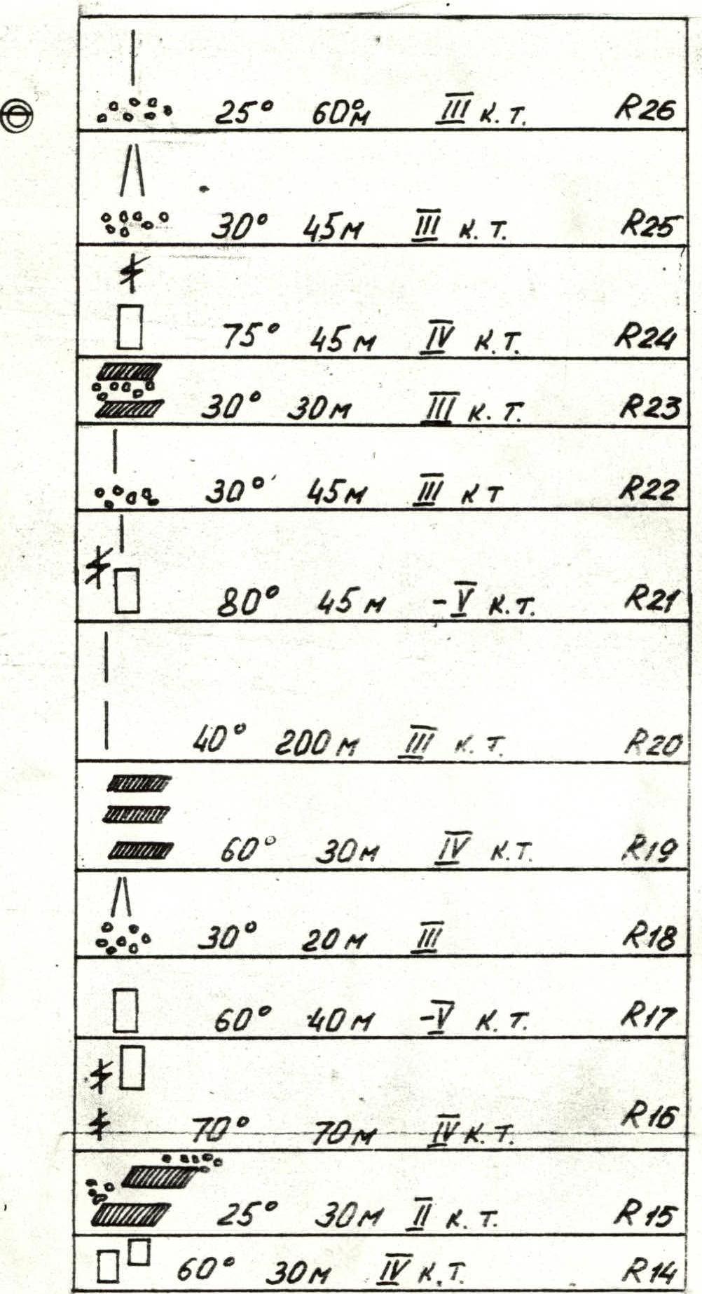
Route diagram in symbols (continued)
- R26: 25° 60 m III cat. diff.
- R25: 30° 45 m III cat. diff.
- R24: 75° 45 m IV cat. diff.
- R23: 30° 30 m III cat. diff.
- R22: 30° 45 m IV cat. diff.
- R21: 80° 45 m IV cat. diff.
- R20: 40° 200 m III cat. diff.
- R19: 60° 30 m IV cat. diff.
- R18: 30° 20 m III cat. diff.
- R17: 60° 40 m IV cat. diff.
- R16: 70° 70 m IV cat. diff.
- R15: 25° 30 m III cat. diff.
- R14: 60° 30 m IV cat. diff.
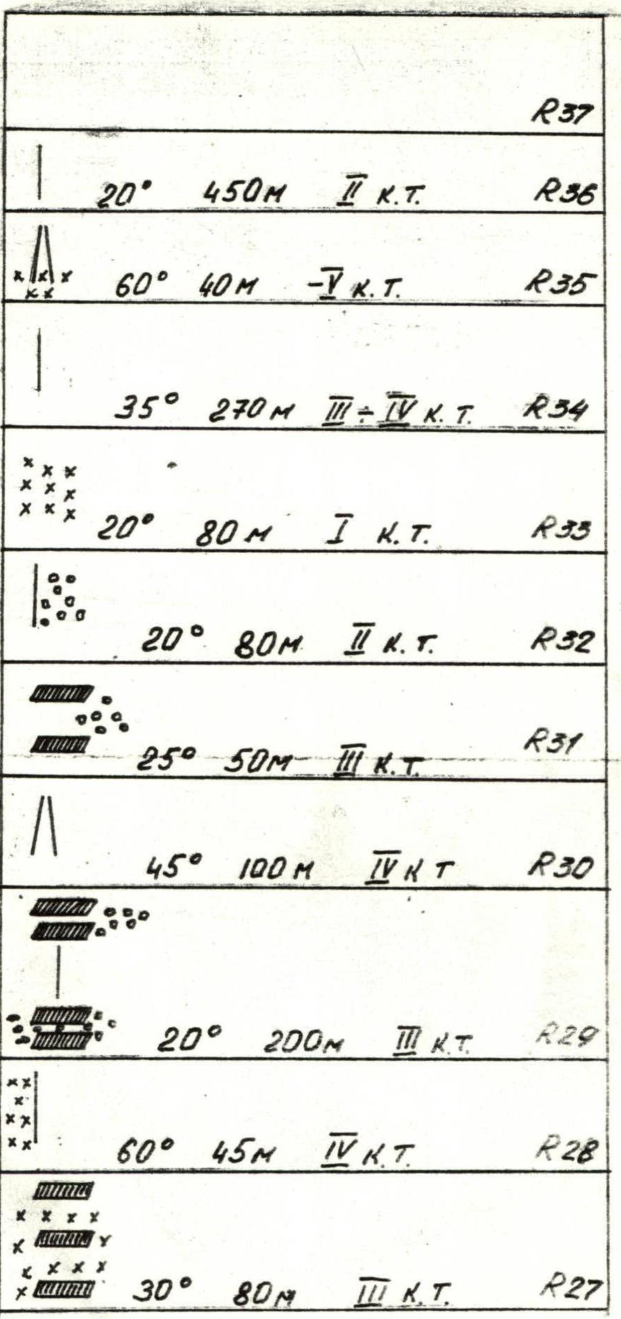
Route diagram in symbols (continued)
- R37
- R36: 20° 450 m II cat. diff.
- R35: 60° 40 m IV cat. diff.
- R34: 35° 270 m III–IV cat. diff.
- R33: 20° 80 m I cat. diff.
- R32: 20° 80 m II cat. diff.
- R31: 25° 50 m III cat. diff.
- R30: 45° 100 m V cat. diff.
- R29: 20° 200 m III cat. diff.
- R28: 60° 45 m IV cat. diff.
- R27: 30° 80 m III cat. diff.