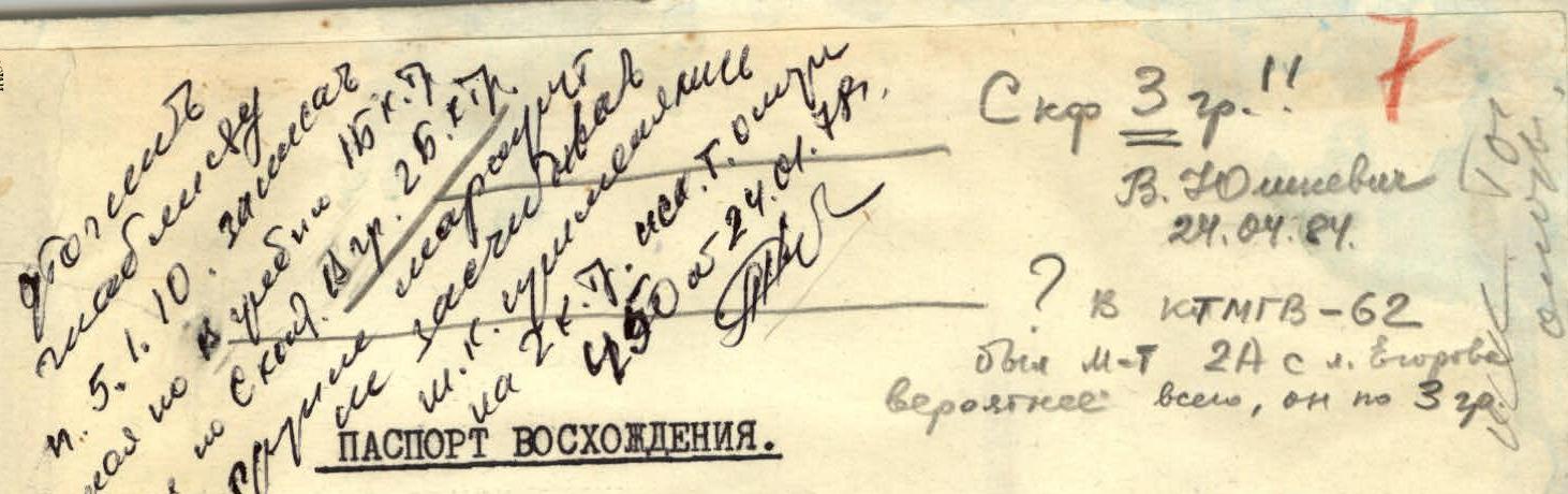
- Class — technical.
- Climbing area — Pamir-Alai, Alai Ridge.
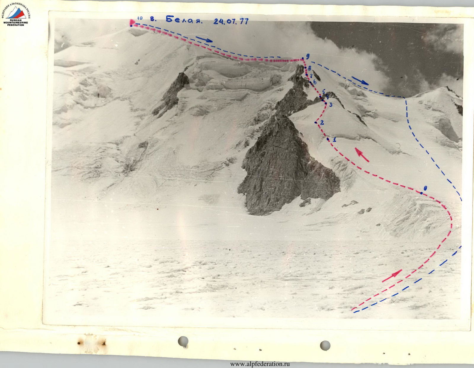
- Peak — Belaya via the North ridge, height 4760 m.
- Proposed difficulty category — 3B.
- Route characteristics:
Height difference — 575 m, length of sections by category: II — 620 m, III — 360 m, IV — 170 m, average steepness — 29°. 6. Pitons hammered:
for belay: rock — 18, ice — ?; for anchors and organization: rock — ?, ice — ?. 7. Total climbing hours — 9.5 hours. 8. Group composition:
Kachur Ivan Ivanovich — leader, 2nd sports category; Mazalevsky Igor Olegovich — participant, 2nd sports category; Kovalenko Alexander Vasilyevich — participant, 2nd sports category; Dashko Oleg Danilovich — participant, 2nd sports category.
9. Team coach — Saprykin Vasily Danilovich, Master of Sports.
10. Date of departure on the route: July 24, 1977.
11. Date of return to base camp: July 24, 1977.
Description of the approach to the route on peak Belaya via the North ridge, 3B category.
From the confluence of the Arch-Kanysh and Dunoba rivers, go up the orographically left side of the Arch-Kanysh river to Egorov Glacier. Then follow Egorov Glacier to the confluence of Tashkent, Akhunbabayev, and Egorov glaciers.
The peak is visible on the left as an ice dome between two rocky peaks:
- "Fighters for Peace"
- "Wings of Soviets"
Travel time from the confluence — 2.5–3.5 hours.
The route follows a distinct ridge descending from the shoulder of the peak.
Area map
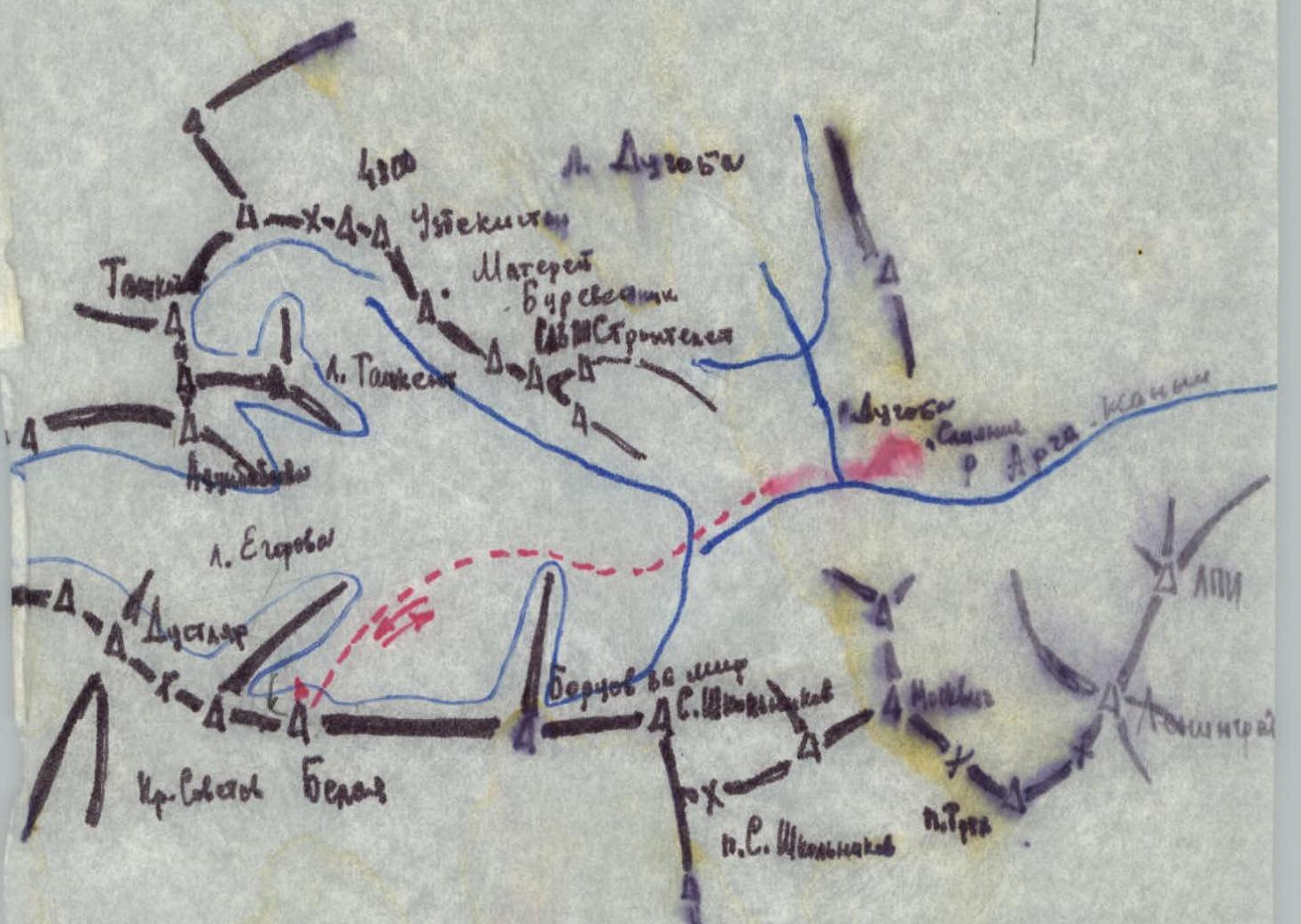
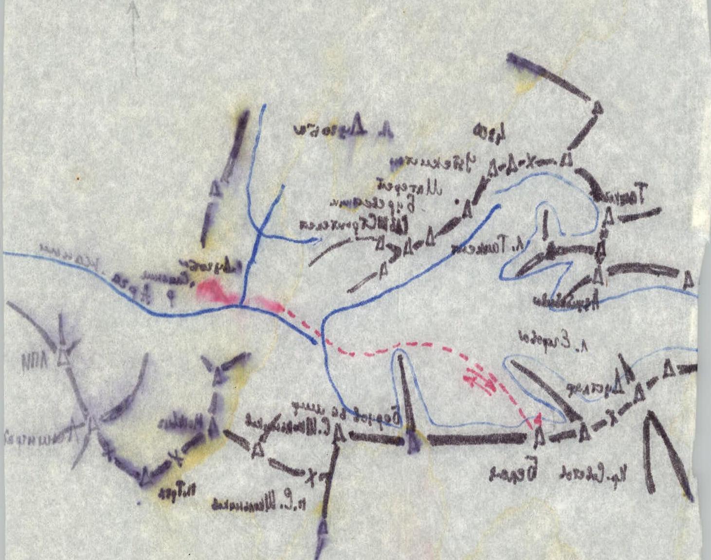
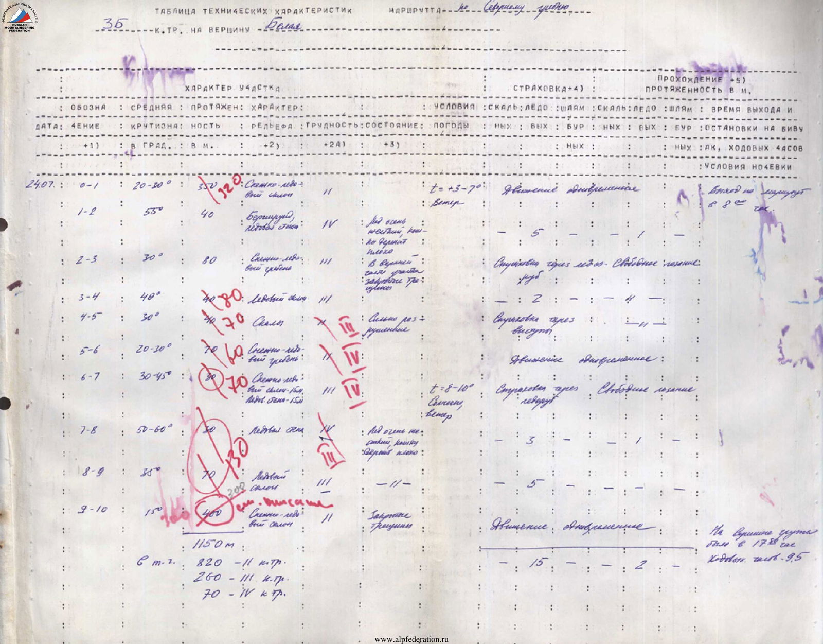
Table of technical characteristics
3B category on peak Belaya
Section characteristics:
- Designation
- Average steepness in degrees
- Length in meters
- Terrain type
- Difficulty
- Condition
- Weather
Belay:
- Rock
- Ice
- Bolts
Passage (length in meters):
- Rock
- Ice
- Bolts
Time and date of departure:
- Start, end, climbing hours
- Bivouac stops
- Night conditions
Data by sections: July 24 (Date) Section 0–1:
- Steepness: 20–30°
- Length: 350 m
- Terrain: Snow-ice slope
- Difficulty: II
- Condition: t=+3–7°, wind
- Belay (rock/ice/bolts): —/—/—
- Passage (rock/ice/bolts): —/—/—
- Time and date of departure: Simultaneous movement
- Bivouac stops: Departure at 8:00
Section 1–2:
- Steepness: 55°
- Length: 40 m
- Terrain: Bergschrund, ice wall
- Difficulty: V
- Condition: Ice very soft, some derit badly
- Belay (rock/ice/bolts): —/5/—
Section 2–3:
- Steepness: 30°
- Length: 80 m
- Terrain: Snow-ice ridge
- Difficulty: II
- Condition: Upper part: closed crevasses
- Belay (rock/ice/bolts): Belay via ice axe
- Passage (rock/ice/bolts): Free climbing
- Bivouac stops: stop.
Section 3–4:
- Steepness: 40°
- Length: 80 m
- Terrain: Ice slope
- Difficulty: II
- Belay (rock/ice/bolts): 2/—/—
Section 4–5:
- Steepness: 30°
- Length: 70 m (rock)
- Terrain: Rock
- Difficulty: II
- Condition: Highly fractured
- Belay (rock/ice/bolts): Belay via rock outcrops
Section 5–6:
- Steepness: 20–30°
- Length: 70 m
- Terrain: Snow-ice ridge
- Difficulty: II
- Time and date of departure: Simultaneous movement
Section 6–7:
- Steepness: 30–45°
- Length: 70 m
- Terrain: Snow slope — 15 m, ice wall — 15 m
- Difficulty: III/IV
- Condition: t=+8–10°, sunny, wind
- Belay (rock/ice/bolts): Ice axe
- Passage (rock/ice/bolts): Belay via outcrops
- Time and date of departure: Free climbing
Section 7–8:
- Steepness: 50–60°
- Length: 30 m
- Terrain: Ice wall
- Difficulty: V
- Condition: Ice very hard, lumps hold poorly
- Belay (rock/ice/bolts): 3/—/—
Section 8–9:
- Steepness: 30°
- Length: 70 m
- Terrain: Ice slope
- Difficulty: III
- Condition: —//—
- Belay (rock/ice/bolts): 5/—/—
Section 9–10:
- Steepness: 15°
- Length: 150 m
- Terrain: Snow-ice slope
- Difficulty: II
- Condition: Closed crevasses
- Time and date of departure: Simultaneous movement
Totals:
- Total length: 1150 m
- Length of category II sections: 820 m
- Length of category III sections: 260 m
- Length of category IV sections: 70 m
- The group reached the summit at 17:30.
- Climbing hours: 9.5.
Brief explanation of the table.
Section R0–R1. Length 320 m, category 2, steepness 20–30°. Move along the snow-ice slope to the right of the rocky triangle of the north ridge towards the saddle on the ice ridge until the bergschrund.
Section R1–R2. Length 40 m, category 4, steepness 35–45°. Overcome the bergschrund via a steep ice wall to reach the saddle of the ridge. Climbing is difficult, piton belay.
Section R2–R3. Length 80 m, category 3, steepness 25–35°. Move along the snow-ice ridge towards the rocky guardeur. "Closed crevasses!" in the upper part of the ridge. Belay via ice axe.
Section R3–R4. Length 80 m, category 3, steepness 30–40°. Bypass the guardeur on the left via an ice slope (40 m), then via broken rocks. Piton and rock outcrop belay.
Section R4–R5. Length 70 m, category 3B, steepness 30–40°. From the guardeur, follow a straightforward snow-ice ridge to a rocky outcrop.
Section R5–R6. Length 60 m, category 4, steepness up to 50°, in some places up to 60°. Move along the snow-ice slope towards the snow col between the rocky ridge and the rocky outcrop. After 10–15 m, an ice wall begins, becoming steeper and turning into an ice ridge at the top. Steepness at the top is up to 60°. Climbing is very difficult with step cutting, piton belay. Do not go onto the rocky ridge, it is highly fractured!!!
Section R6–R7. Length 70 m, category 4, steepness 35–45°. From the upper boundary of the rocks, move left-up along the ice slope to the snow-ice ridge. Piton belay.
Section R7–R9. Length 130 m, category 3, steepness 40–45°. Follow the snow-ice ridge right-up to the pre-summit shoulder. Cornices on the right; move to the right of their breaking line. Piton belay.
Section R9–R10. Length 300 m, category 2, steepness 10–20°. From the shoulder, move left along a straightforward ice-snow slope towards the rocks on the summit. "Caution — closed crevasses!"


