Ascent Passport
- Ascent class — high-altitude and technical.
- Ascent area — Central Tian Shan, Meridionalny Ridge.
- Peak, its height, ascent route — Pogrebetsky Peak, western summit, 6487 m, via the western wall.
- Proposed difficulty category — 6.
- Route characteristics: height difference — 2070 m; section lengths:
- cat. diff. 5 — 150 m,
- cat. diff. 6 — 300 m; average steepness of the rock part of the route — 63°, including the wall — 70°.
- Pitons hammered: for belaying: rock — 141, ice — 30, bolted — none; for creating intermediate protection: rock — 9, ice — 4, bolted — none.
- Number of working hours — 56 hours.
- Number of nights — 8, their characteristics: lying down — 6, semi-reclining — 2, on rock platforms — 3, on ice, carved into the slope — 5.
- Surname, name, patronymic of the team leader, participants, and their qualification:
- Streletsov Evgeny Alexandrovich — CMS, team leader;
- Alibegashvili Levan Markovich — MS, participant;
- Budyanov Valery Pavlovich — CMS, participant;
- Meshkov Igor Nikolaevich — MS, participant.
- Team coach — Biryukov Vladimir Nikolaevich, CMS, category 1 instructor.
- Date of departure to the route — August 1, 1980, return date — August 10, 1980.
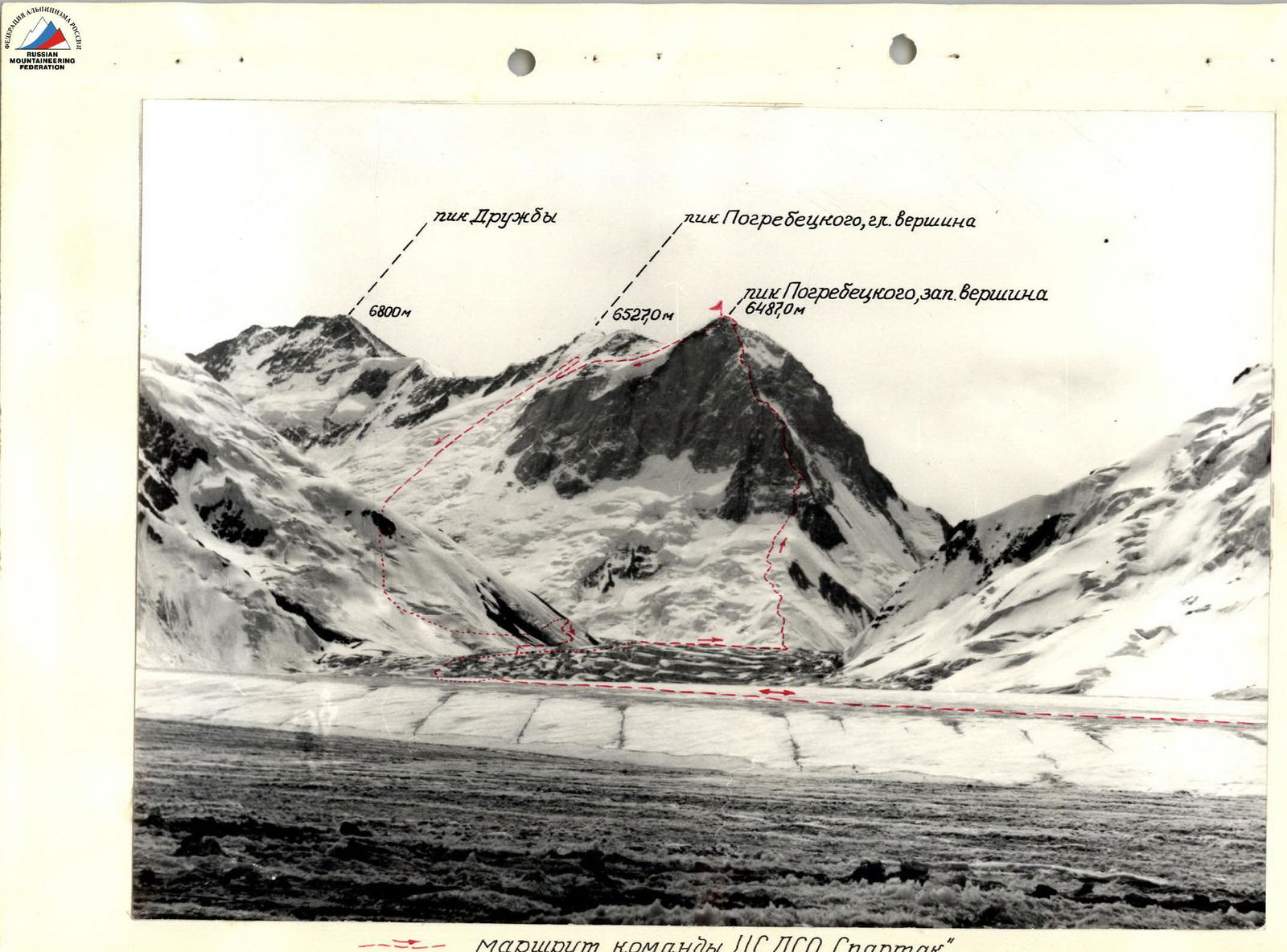
— route of the CS DSO "Spartak" team
Cartographic diagram of the upper reaches of the South Inylchek Glacier

Conventional symbols
- ⇒ assault group route
- base camp
- assault camp
- bivouacs
Brief description of the approach to the route
Pogrebetsky Peak (western summit) with a height of 6487 m is located in the western spur of the Meridionalny Ridge, dividing the Druzhby and E. Nagel glaciers (right tributaries of the South Inylchek Glacier).
The ascent was made from a base camp located on the right-bank moraine of the South Inylchek Glacier under the slopes of Maly Gorky Peak.
The approach to the route is made along the middle part of the South Inylchek Glacier; the icefall in the area of the knee-shaped bend of the glacier is bypassed on the left in the direction of travel.
The section of the glacier south of the bend is abundant with hidden crevasses.
The journey from the base camp to the assault camp, located on the South Inylchek Glacier at the foot of the western wall of Pogrebetsky Peak, takes 5 hours. It is also possible to locate the assault camp on the right-bank moraine of the Druzhby Glacier under the southern slope of Otkrytiy Peak (6 hours from the base camp).
Information about reconnaissance exits and supply trips
The Spartak DSO expedition arrived by helicopter from Przhevalsk to the South Inylchek Glacier. On July 23, a reconnaissance group consisting of:
- Streletsov E.A.
- Alibegashvili L.M.
- Meshkov I.N.
- Budyanov V.P.
- Mardezhov A.S.
- Onin A.A.
was sent to Pogrebetsky Peak (6487 m).
As a result of the exit, the approach to the foot of the western wall of Pogrebetsky Peak was reconnoitered, and an assault camp was established. On the same day, the group returned to the base camp.
After selecting equipment and supplies, a second exit was made (July 26-28, 1980), during which the lower, snow-ice part of the route (sections R0-R11) was processed on July 27, 1980, by the team consisting of Streletsov E.A., Alibegashvili L.M., Budyanov V.P., and Meshkov I.N., and supplies and equipment were delivered to the base of the rock part of the route.
The observation group, consisting of Mardezhov A.S. and Onin A.A., was at the assault camp during this time.
On July 28, 1980, the team returned to the base camp and, after two days of rest and preparation (July 29-30), departed for the assault camp on July 31, 1980.
Composition of the observation group
Observation of the team was carried out by groups of the following composition:
- from July 27 to August 2, 1980:
- Mardezhov A.S., CMS;
- Onin A.A., CMS;
- from August 3 to August 8, 1980:
- Petko V.I., CMS;
- Zhdanovich A.E., CMS;
- from August 9 to August 10, 1980 — by the meeting and observation group:
- Prokopenko V.I., MS;
- Vodopyanov S.K., CMS;
- Krivopalov A.I., 1st category;
- Knyazev G.G., 1st category.
Tactics of the ascent
The choice of tactics was determined by the nature of the route and the specifics of the meteorological conditions in Central Tian Shan. In this regard, it was decided:
- To process the lower, snow-ice part of the route in advance (1 day);
- To build the ascent on the principle of a "secure rear": the team did not dismantle the bivouac until the first rope team found a suitable place for the next bivouac.
This tactic proved to be entirely justified and allowed for a successful ascent, despite the fact that out of the 10 days during which the ascent was made, only 3 days (August 1, 7, and 10) had good weather. The poor weather explains the low number of working hours on some days of the ascent (see table). However, the team tried to work every day for at least a few hours to avoid "sitting around."
When passing the route, the first person climbed with a lightened backpack or without a backpack, and the other three ascended on a rope using jammers (one chest and one foot jammer). This tactic and technique of movement made it possible to practically avoid the labor-intensive and time-consuming process of pulling up backpacks.
To ensure the safety of the first person:
- A Saratkin shock absorber was constantly used;
- On difficult sections — a double rope.
The use of the Saratkin shock absorber, which does not require ensuring rope tension in case of a fall by the first person, allowed the first person in the rope team to move 40 m with a fairly large number of intermediate belay points. All this contributed to speeding up the passage of the route and increasing safety.
To speed up the extraction of pitons, a hammer with a chain extractor was used, which proved itself on the complex rock terrain.
All team members worked in belts — harnesses of the "sit harness" type. For the first person, in poor weather conditions, a lightweight down jacket was used, which, unlike a down suit, did not interfere with work on the rocks.
Measurements of the steepness of the route sections were made with a clinometer from a mountain compass with an accuracy of 1-20°.
Table of main route characteristics
| Date | Designation | Average steepness, ° | Length, m | Terrain characteristics | Difficulty | Condition | Weather conditions | Pitons: rock | Pitons: ice | Pitons: bolted |
|---|---|---|---|---|---|---|---|---|---|---|
| July 27, 1980 | R0–R1 | 30 | 120 | ice-firn slope with closed crevasses | II | fresh snow cover | clear, sunny | – | – | – |
| R1–R2 | 45 | 50 | sharp ice ridge | V | –"– | –"– | – | 3 | – | |
| R2–R3 | 40 | 60 | snow slab | IV | –"– | –"– | through | ice axe | – | |
| 10 | bare ice | IV | –"– | –"– | – | 1 | – | |||
| R3–R4 | 45 | 40 | sharp ice ridge | IV | –"– | –"– | – | 3 | – | |
| R4–R5 | 45 | 40 | ice-firn slope | IV | –"– | –"– | through | ice axe | – | |
| R5–R6 | 45 | 40 | ice-firn slope with a thick (up to 1 m) layer of loose, powdery snow and three crevasses like a bergschrund | VI | fresh snow cover | clear, sunny | through | 1 | – | |
| R6–R7 | 20 | 120 | wide ice-firn ridge with closed crevasses | III | –"– | –"– | simultaneously | through ice axe | – | |
| R7–R8 | 30–45 | 240 | firn slope with closed crevasses | II | –"– | –"– | – | 1 | – | |
| 50–60 | 70 | –"– | V | –"– | –"– | – | 1 | – | ||
| 45 | 10 | ice | I | –"– | –"– | – | 1 | – | ||
| R8–R9 | 60 | 30 | firn slope adjacent to two bergschrund walls | VI | layer of powdery snow up to 0.5 m, under it dense crust | –"– | through | 2 | step cutting | |
| R9–R10 | 45 | 90 | firn slope | IV | fresh snow cover 0.2–0.3 m | –"– | through | 3 | – | |
| R10–R11 | 80 | 3 | bergschrund wall | VI | –"– | –"– | – | 3 | – | |
| 55 | 60 | ice slope | V | –"– | –"– | – | 4 | – | ||
| R11–R12 | 60 | 50 | rock wall | V | destroyed, icy rocks | clear, sunny | 7 | – | – | |
| 90 | 10 | –"– | V | destroyed, icy rocks | –"– | – | – | – | ||
| R12–R13 | 75 | 30 | wide inner corner | V | destroyed, icy rocks | –"– | 5 | – | – | |
| 80 | 25 | wall | V | –"– | –"– | 3 | – | – | ||
| 60 | 15 | slabs | V | covered with ice | –"– | 2 | – | – | ||
| R13–R14 | 50 | 60 | firn-ice slope | V | fresh snow cover (5–10 cm) | –"– | step cutting | 2 | – | |
| R14–R15 | 75 | 20 | rock wall | V | monolith | overcast | 6 | – | – | |
| R15–R16 | 60 | 20 | slabs | VI | monolith, ice | overcast | 6 | 1 | – | |
| 75 | 20 | rock wall | VI | –"– | snowfall | 3 | – | – | ||
| 90 | 5 | inner corner | V | monolith | –"– | 2 | – | – | ||
| R16–R17 | 70 | 30 | inner corner | V | heavily destroyed rocks | –"– | 3 | – | – | |
| 80 | 8 | wall | V | monolith | snowfall | 2 | – | – | ||
| August 2, 1980 | R17–R18 | 45 | 35 | inclined slabby ledges | III | rockfall-prone rocks | wind, frost, snowstorm | ledges | – | – |
| 80 | 30 | rock wall with chimneys | V | monolith | –"– | 2 | – | – | ||
| 80 | 10 | inner corner | V | monolith | –"– | 2 | – | – | ||
| 50 | 7 | inclined ledge | III | destroyed rocks | –"– | ledges | – | – | ||
| 90 | 10 | narrow chimney | V | monolith | –"– | 2 | – | – | ||
| 30 | 25 | inclined ledge | IV | destroyed rocks | –"– | 3 | – | – | ||
| August 4, 1980 | R19–R20 | 80 | 35 | inner corner | VI | monolithic rocks, covered with ice | wind, snow, snowstorm | 6 | 4 | – |
| 55 | 10 | ice gully | V | –"– | –"– | 2 | – | – | ||
| 50 | 10 | snow-ice slope | V | –"– | –"– | – | – | – | ||
| 90–100 | 15 | rock wall with a wide gap | VI | monolith, ice | –"– | 3 | 1 | – | ||
| 80 | 7 | rock wall | IV | destroyed rocks | –"– | 1 | – | – | ||
| August 5, 1980 | R20–R21 | 45 | 10 | snow-firn slope | IV | fresh snow | snow, wind, fog | rock ledges | – | – |
| 80 | 15 | inner corner | VI | ice | –"– | 3 | – | – | ||
| 90–100 | 10 | inner corner | VI | –"– | –"– | 2 | – | – | ||
| 85–100 | 60 | inner corner | VI | –"– | –"– | 9 | 11 | – | ||
| R21–R22 | 20 | 10 | rock ledge | III | snow-covered | –"– | rock ledges | – | – | |
| 50 | 20 | snow-ice slope | IV | fresh snow | –"– | rock ledges | – | – | ||
| 90 | 15 | rock wall | V | destroyed rocks | –"– | 2 | – | – | ||
| 70 | 15 | rock wall | V | –"– | –"– | 2 | – | – | ||
| 70 | 10 | slabs | V | snow-covered | –"– | 2 | – | – | ||
| R22–R23 | 35–40 | 75 | rock-snow-ice counterfort | III | fresh snow | –"– | ledges | ice axe | – | |
| August 6, 1980 | R23–R24 | 50–60 | 60 | rocky slope of a gendarme | IV | destroyed rocks | snow, wind, fog, occasional blizzard | 3 | rock ledges | – |
| 60–70 | 40 | –"– | V | –"– | –"– | 4 | – | – | ||
| 45 | 20 | snow-ice slope | IV | fresh snow | –"– | – | 2 | – | ||
| R24–R25 | 80 | 10 | rock wall | V | monolith | –"– | 2 | – | – | |
| 90 | 5 | –"– | V | destroyed rocks | –"– | 2 | – | – | ||
| 60 | 20 | counterfort ridge | IV | –"– | –"– | 2 | – | – | ||
| August 7, 1980 | R25–R26 | from –30 to +50 | 60 | sharp snow bridge on a rocky base | V | fresh snow, cornices | clear, sunny, cold, wind | through | 4 ledges | – |
| R26–R27 | 80 | 10 | rock wall of a gendarme | VI | tiled rock structure | –"– | 3 | 1 (pendulum 4 m) | – | |
| R27–R28 | 60 | 15 | slabs | VI | monolith | clear, sunny, cold, wind | 3 | 1 (pendulum 6 m) | – | |
| 90 | 15 | rock wall | V | destroyed rocks | –"– | 3 | – | – | ||
| 80 | 20 | rock wall | V | monolith | –"– | 4 | – | – | ||
| 80 | 5 | –"– | V | –"– | –"– | 2 | – | – | ||
| 60 | 10 | rock ledge | IV | destroyed rocks | –"– | 2 | – | – | ||
| 65 | 20 | rocky slope | IV | –"– | –"– | 2 | – | – | ||
| 60 | 30 | rocky slope | IV | destroyed, loose rocks | –"– | ledges | – | – | ||
| 70 | 40 | rocky slope | V | rocks of block structure | –"– | 3 | – | – | ||
| R28–R29 | 45–50 | 140 | snow ridge on smoothed slabs like "sheep's foreheads" or on an icy substrate | V | fresh snow, местами инееобразный | –"– | 11 | 2 | – | |
| August 8, 1980 | R29–R30 | 30–60 | 150 | snow-firn ridge | IV | fresh snow cover (up to 0.5 m) | fog, snow, wind (occasional blizzard) | – | through ice axe | – |
| R30–R31 | 70 | 250 | rocky slope | V | snow-covered, covered with ice | –"– | 10 | rock ledges | – | |
| R31–R32 | 30 | 150 | summit ridge | III | loose snow up to 1 m deep | gusty wind, blizzard | – | through ice axe | – |
Time of departure — 6:00, start of descent — 16:30, return to the assault camp — 19:00, working hours (ascent) — 9.5 hours.
Time of departure — 5:00, time of stopping at a bivouac — 19:00 (passage of the processed section took 6 hours), working hours for the day — 13 hours. Overnight stay in a tent, semi-reclining.
Time of departure — 11:00, time of return to the bivouac — 16:00, working hours — 4.5 hours; the place and conditions of the overnight stay are the same as on August 1, 1980.
Due to the continuing bad weather throughout the night and morning (fog, snow, gusty, squally wind up to hurricane force), the section R17-R18 was passed along the perlines, and the team stopped at a bivouac. Time of departure — 11:30, time of stopping at a bivouac — 13:30, working hours — 2 hours. Overnight stay in a tent, lying down.
Time of departure — 8:00, time of stopping at a bivouac — 14:30, working hours — 6.5 hours. Overnight stay in a tent, in a carved ice niche, semi-reclining.
Time of departure — 9:30, time of stopping at a bivouac — 17:30, working hours — 8.0 hours. Overnight stay on a carved ice platform in a tent, lying down. A control tour was installed on a rocky ledge next to the platform.
Time of departure — 10:30, time of stopping at a bivouac — 14:30, working hours — 4.0 hours. Overnight stay in a tent, on a carved ice platform, lying down (after section R23-R24).
Time of departure — 9:30, time of stopping at a bivouac — 19:00, working hours — 9.5 hours. Overnight stay in a tent on a platform carved in ice, lying down.
Time of departure — 12:00, time of reaching the summit — 16:00, time of stopping at a bivouac on the saddle between the western and main summits — 17:00, working hours — 5.0 hours. Overnight stay in a tent on a snow platform, lying down.
Descent from the summit
August 9, 1980. Time of departure — 10:00, time of stopping at a bivouac — 15:00, working hours — 5.0 hours. A search was made for a descent route in conditions of fog and snowfall.
Team composition:
August 10, 1980. Time of departure at 10:00. In clear, sunny weather, with the help of the meeting and observation group, which coordinated the team's actions from the Druzhby Glacier via radio communication, it was possible to quickly find the optimal descent route along the icefall.
At 15:45, the team descended to the Druzhby Glacier.
In total, the following were hammered on the route for belaying:
- rock pitons — 141;
- ice pitons — 30;
- for creating intermediate protection:
- rock pitons — 9,
- ice pitons — 4.
Schematic profile of the route
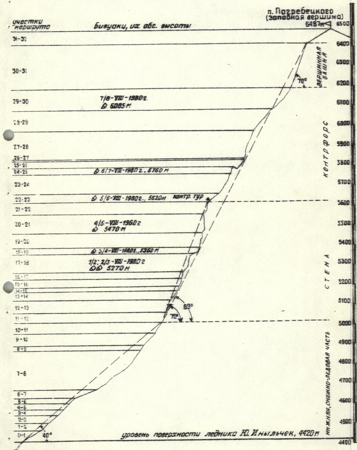
Brief explanation of the table
Schematically, the route can be divided into 4 parts:
- lower, snow-ice part;
- wall;
- counterfort;
- summit tower.
Below are the average characteristics of each section:
| Section | Length, m | Height difference, m | Average steepness, ° | Interval of absolute heights, m |
|---|---|---|---|---|
| 1. Lower part | 980 | 600 | 40° | 4420–5020 |
| 2. Wall | 700 | 600 | 70° | 5020–5620 |
| 3. Counterfort | 850 | 570 | 55° | 5620–6190 |
| 4. Summit tower | 400 | 300 | 70° | 6190–6487 |
For the lower, snow-ice part of the route, a characteristic feature and main difficulty when passing was the presence of sections with a rather thick (up to 1 m) layer of loose, powdery snow lying on an ice-firn slope broken by crevasses (section R5-R6). The powerful snow cover prevented the use of ice pitons for belaying, and belaying through an ice axe in loose, powdery snow was difficult to implement and unreliable. When passing this section, the leader ahead made a trench more than 1 m deep with belaying through an ice axe in the underlying denser firn.
Another feature of this part of the route was the presence of a section with a cover of loose snow up to 0.5 m thick, under which lies a very dense, hard crust not pierced even by an ice axe (section R8-R9). This section was passed with lower belaying through ice pitons and an ice axe, with step cutting in the dense crust.
It is recommended to pass the lower part of the route before 12:00, as after this time, movement becomes very difficult due to the snow softened by the sun.
The wall part of the route is characterized by the presence of two types of rocks:
- tiled, heavily weathered, destroyed rocks, represented by slaty limestones of dark gray and black color, and
- strong, more or less monolithic rocks, represented by layers of massive, dense, sometimes marbleized limestones of pinkish and brownish-yellow color.
The relief of the tiled, heavily weathered rocks is characterized by the presence of rock walls and wide inner corners with a steepness of 60 to 75°, increased rockfall hazard, and unfavorable conditions for belaying both through pitons and through ledges due to the strong destruction of the rocks. The relief of monolithic rocks is characterized by the presence of steep up to 80-90° walls and more or less monolithic rock walls and bastions with chimneys and inner corners, slabs, overhanging rocks — most sections of category V and the overwhelming majority of key sections of category VI. The rockfall hazard here is significantly lower, and belaying is much more reliable due to the strength and monolithicity of the rocks (sections from R14-R15 to R20-R21). Among the monolithic rocks, zones of crushed, heavily destroyed limestones are found in a sharply subordinate quantity.
It should be noted that this part of the route is very late (after 11:30-12:00) illuminated by the sun (closed by the summit), and, in connection with this, cold in the early hours, and to a large extent, covered with ice, especially in the negative elements of the rock relief:
- inner corners;
- chimneys;
- etc.
The counterfort is characterized in its lower half by an alternation of steep ice-firn sections with separating them "gendarmeries," the bypass or overcoming of which "head-on" presents significant difficulties (sections R26-R27 and R27-R28). The "gendarmeries" are composed mainly of massive, monolithic limestone rocks, occasionally interspersed with rocks of tiled structure (section R26-R27). The upper part of the counterfort consists of destroyed, loose rocks and rocks of block structure and turns into a wide ridge composed of smoothed rocks like "sheep's foreheads," slabs with interspersed icy sections, and covered with fresh, and in places, powdery (frosty) snow (section R28-R29). The counterfort ends with a snow-firn ridge turning into a snow-firn slope at the foot of the summit tower.
The summit tower from the west is a rocky, steep (about 70°) slope composed of heavily destroyed limestone rocks of block structure, with low (2-3 m) walls, snow-covered and covered with ice, with small icy sections covered with powdery (frosty) loose snow. Movement, as well as the organization of belaying, is very difficult here due to the abundance of "live" stones and rock blocks. Due to the heavy snow cover, it is difficult to use pitons (you need to clear the snow), and belaying through an ice axe is unreliable due to the loose, powdery snow.
The summit ridge is framed by a strip (layer) of clearly distinguishable black shales, which also compose the summit (the movement to the highest point — the icy dome — is made along the boundary of rocks and snow).
Equipment table
| № p/p | Name of clothing, equipment, footwear | Quantity | Approximately on sections according to the table | Total weight, kg |
|---|---|---|---|---|
| 1. | Tent — Pamirka | 1 | at bivouacs | 3 |
| 2. | Rope 80 m | 2 | constantly | 8.0 |
Assessment of the route and recommendations for its passage
The significant length of the route (about 3 km) and the height difference (about 2 km), the saturation of the route with sections of the highest difficulty category, located at absolute heights of 5000–6000 m, allow us to conclude that the route deserves a classification of 6B difficulty category.
The team considers it most expedient to make ascents on this route in groups of 4 people due to the lack of places for overnight stays and the generally wall-like nature of the route.
The route is not characterized by increased danger and does not require special precautions, except for those usual for this area. It should be noted that there is a possibility of avalanche danger after heavy snowfalls in the lower (initial) part of the route and on the descent through the icefall.
Information about team training
The combined team of the CS DSO "Spartak" was formed on the basis of two teams: the alpinism sections at the Kyrgyz Republican and Novosibirsk Regional Councils of the DSO "Spartak".
In preparation for participating in the USSR championship, team members conducted training during the off-season in general physical preparation and rock climbing. In May 1980, they participated in the May alpine gathering in the area of the Ala-Archa alpine camp (ascents of 3B category). In addition, team members V. Budyanov and I. Meshkov underwent a 30-day training camp in July 1980 in the Ala-Archa alpine camp, where they made ascents on peaks up to 5B category, including:
- the Ruzhevsky route on the V tower of the Corona in a double;
- routes of 5B category on the VI and I towers of the Corona.
It should also be noted that all team members made from 1-2 to 3-4 ascents of 5B difficulty category in the previous 1979 season, including on peaks with heights over 5000 m.
Notes from the summit and control tours on the route
Pogrebetsky Peak (western summit) with a height of 6487 m was previously an unconquered peak. The team made a first ascent on it and left two notes in control tours:
- At the exit from the wall to the counterfort (section R22-R23) on a rocky ledge of a gendarme;
- On the summit ridge, on a rocky outcrop 50 m below the highest point of the snow dome of the summit.
Copy of the note from the control tour: August 5, 1980, 17:30.
The CS DSO "Spartak" team consisting of:
- Streletsov E.A. — team leader;
- Alibegashvili L.M.;
- Budyanov V.P.;
- Meshkov I.N.,
participating in the XXXI USSR Championship in alpinism, is making an ascent on the western summit of Pogrebetsky Peak (6487 m) via the western wall. Having left the assault camp on the South Inylchek Glacier on August 1, 1980, the team today reached the base of the counterfort. Everything is fine in the team. The weather is very bad — snow, wind, fog. Greetings to the next climbers!
Streletsov.
![img-11.jpeg]({"width":888,"height":1526,"format":"Jpeg","uri":"https://summitx.info/media/1/3w↗