
Ascent Passport
I. Ascent class - technical 2. Ascent area - Western Tian-Shan, Pskem Ridge 3. Ascent route - peak "Koi-Tau" 3560 m via North-Eastern counterfort 4. Estimated complexity category - 4A 5. Route characteristics: - height difference - 520 m - average steepness - 66° 6. Pitons hammered: - rock - 68 - ice - - bolted - 7. Number of climbing hours - 9:00 8. Number of overnight stays - none 9. Full name of the leader, participants, and their qualification 1. Zvezdin A.I. - 2nd sports category, leader 2. Sarafankin Yu.A. - 2nd sports category 3. Metalev V.I. - 2nd sports category 4. Spitsin S.K. - 2nd sports category 5. Simanovskiy S.K. - 2nd sports category 10. Team coach - Ovcharov G.N. II. Date of departure and return - June 23, 1982
KOI-TAU PEAK - 3560 m. ROUTE VIA NORTH-EASTERN COUNTERFORT 4A complexity category.
(front view photograph of the route)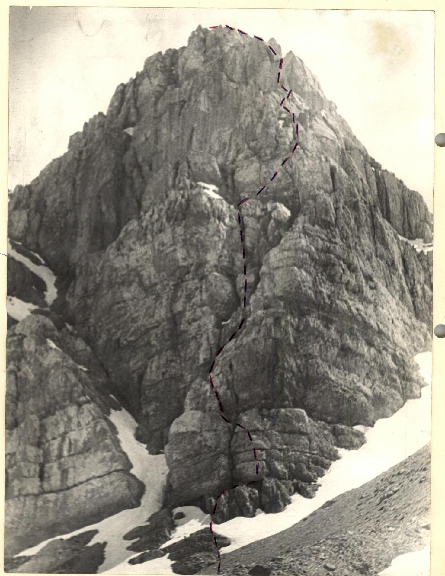
Route Description
to peak "Koi-Tau" via North-Eastern counterfort 4A complexity category.
A good trail leads to the base camp from ispai settlement. Travel time from ispai to base camp is 2 hours. From the base camp, ascend via the left tributary of the ispai-sai river to the second confluence and then via moraine to the cirque formed by the peaks:
- "Nadezhda"
- "Zamok"
- "Koi-Tau" Travel time from base camp is 3-4 hours.
From the assault camp, approach to the start of the route is via moraine. R0–R1. The route begins from a rock ledge under the ridge. From the ledge, ascend 30 m via a rocky ridge with 65° steepness to a ledge (1.5 × 2).
I control point.
R1–R2. Ascend 10 m via a crack with 85° steepness from the ledge.
R2–R3. Then traverse from right to left via a 5 m vertical wall with 85° steepness to the second crack.
R3–R4. Continue from right to left via the crack 15 m with 70° steepness upwards to a 10 m ledge with 45° steepness.
R4–R5. Traverse the ledge from left to right under a vertical wall 10 m with 45° steepness.
R5–R6. Ascend 6 m via the wall with 80° steepness to a debris-covered slab to a chimney with a plug.
R6–R7. Bypass the chimney from the right via a 10 m wall with 75° steepness, exiting to a ledge (1.5 × 2) with 45° steepness.
R7–R8. Continue upwards via a wide crack 10 m with 85° steepness.
R8–R9. Enter the chimney 5 m with 80° steepness.
R9–R10. After exiting the chimney, ascend 40 m left upwards via horizontal ledges alternating with 6 m walls with 45° steepness to a 40 m rock shoulder. From the rock shoulder, ascend 40 m right upwards via ledges alternating with 4-5 m walls with 45° steepness in the direction of the ridge.
R10–R11. Ascend 4 m via the ridge with 80° steepness to exit under a wall.
R11–R12. Then traverse 10 m right via a heavily damaged ledge under the wall.
R12–R13. Ascend 10 m via the wall with 85° steepness to exit to a large horizontal ledge (8 × 1.5). From the ledge, ascend 4 m via a sharp ridge to the right into a chimney.
R13–R14. Ascend 35 m via the chimney with 70° steepness to exit to a ledge (it is recommended to move along the left side of the chimney, exiting to the wall).
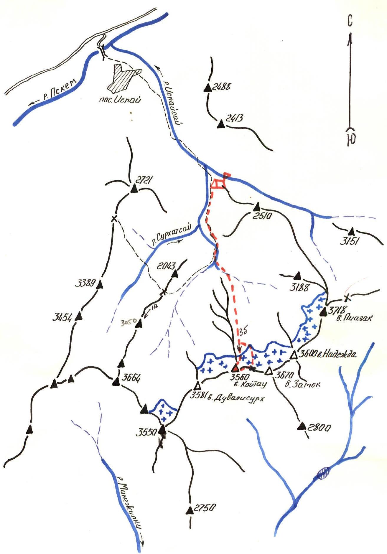
Area Map
PSKEM RIDGE. WESTERN TIAN-SHAN.
R14–R15. Continue via a wall with an internal angle (key section). Exit to a ledge via the left side of the internal angle. The section is 40 m long with 85° steepness. R15–R16. Continue along the ridge, moving with alternating belay through ledges to the summit 400 m with 40° steepness.
Descend from peak Koi-Tau along the ridge to "Medvezhiy" pass. Descend from the pass via a snow-ice slope to the moraine to the assault camp.
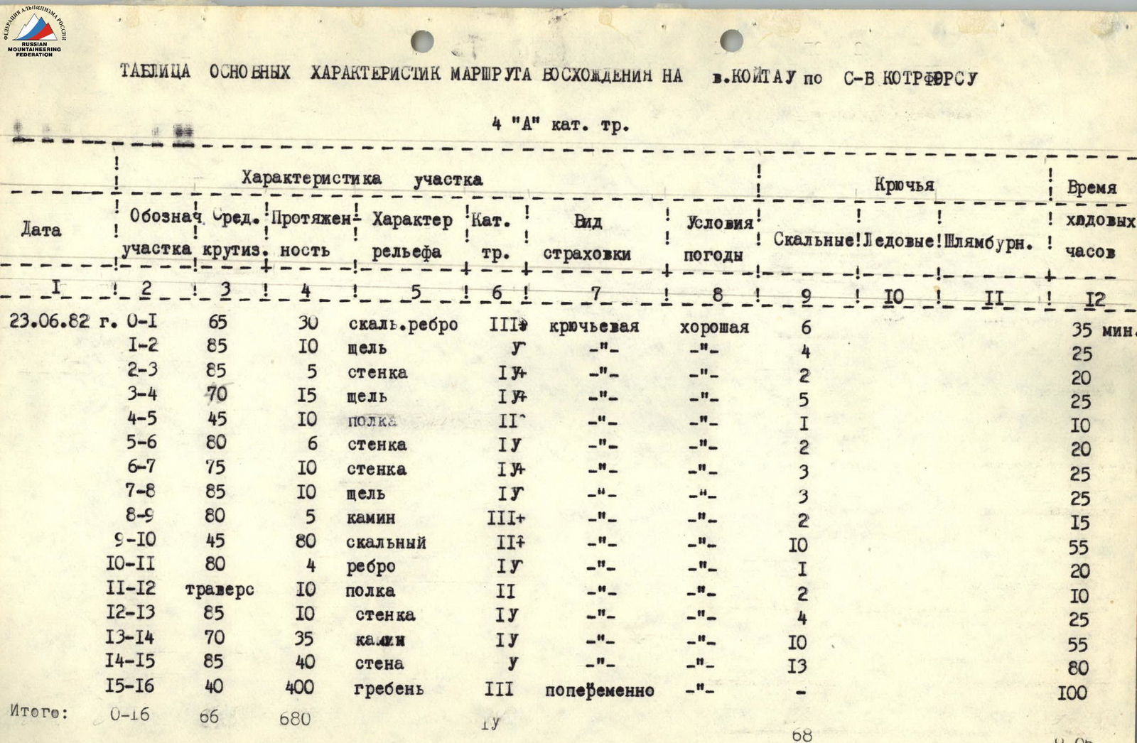
Table of Main Ascent Route Characteristics
to peak Koi-Tau via North-Eastern counterfort 4A complexity category.
| Date | Section designation | Average steepness | Length | Terrain characteristics | Complexity category | Belay type | Weather conditions | Rock Pitons | Ice | Bolted | Climbing time |
|---|---|---|---|---|---|---|---|---|---|---|---|
| June 23, 1982 | R0–R1 | 65° | 30 m | rocky ridge | 3 | piton | good | 6 | 35 min | ||
| R1–R2 | 85° | 10 m | crack | 1 | - | - | 4 | 25 min | |||
| R2–R3 | 85° | 5 m | wall | 1 | - | - | 2 | 20 min | |||
| R3–R4 | 70° | 15 m | crack | 1 | - | - | 5 | 25 min | |||
| R4–R5 | 45° | 10 m | ledge | 2 | - | - | 1 | 10 min | |||
| R5–R6 | 80° | 6 m | wall | 1 | - | - | 2 | 20 min | |||
| R6–R7 | 75° | 10 m | wall | 1 | - | - | 3 | 25 min | |||
| R7–R8 | 85° | 10 m | crack | 1 | - | - | 3 | 25 min | |||
| R8–R9 | 80° | 5 m | chimney | 3 | - | - | 2 | 15 min | |||
| R9–R10 | 45° | 80 m | rocky | 2 | - | - | 10 | 55 min | |||
| R10–R11 | 80° | 4 m | ridge | 1 | - | - | 1 | 20 min | |||
| R11–R12 | 45° | 10 m | ledge | 2 | - | - | 2 | 10 min | |||
| R12–R13 | 85° | 10 m | wall | 1 | - | - | 4 | 25 min | |||
| R13–R14 | 70° | 35 m | chimney | 1 | - | - | 10 | 55 min | |||
| R14–R15 | 85° | 40 m | wall | 1 | - | - | 13 | 80 min | |||
| R15–R16 | 40° | 400 m | ridge | 3 | alternating | - | - | 100 min | |||
| Total: | R0–R16 | 66° | 680 m | 68 | 9 h 05 min |

Graphical Representation of the Ascent Route
to peak "Koi-Tau" via North-Eastern counterfort 4A complexity category and its representation in UIAA symbols.
R15–R16 ridge 400 m 40° 3 R14–R15 wall 40 m 85° 1 R13–R14 chimney 35 m 70° 1 R12–R13 wall 10 m 85° 1 R11–R12 traverse via ledge 10 m 2 R10–R11 ridge 4 m 80° 1 R9–R10 rocks 80 m 45° 2 R8–R9 chimney 5 m 80° 3 R7–R8 crack 10 m 85° 1 R6–R7 wall 10 m 75° 1 R5–R6 wall 6 m 80° 1 R4–R5 inclined wall 10 m 45° 2 R3–R4 70° 15 m. Cracks 1 R2–R3 wall 5 m 85° 1 R1–R2 crack 10 m 85° 1 R0–R1 ridge 30 m 65° 3
Comments
Sign in to leave a comment