
Zamok (3670) via the center of the North Ridge — 5A (rock)
Climbing Route Passport:
- Western Tian Shan, Pskem Ridge, section №7.14 according to the 2013 classifier
- Zamok peak (3670 m) via the center of the North Ridge (c. N. r.)
- 5A category of difficulty
- First ascent: Sergeev A. (1982)
- Description compiled by: Shekhovtsov S., Makhmudov U., Mayorova L. (2013)
Route Description:
From the base camp on the moraine under Zamok peak, it takes 1 hour to reach the foot of the wall via scree or snow. Approach the wall, bypassing a massive red "rhombus" on the right, which is half the height of the wall. Above the "rhombus," a rock ridge is clearly visible, along which the route goes.
Start of the route. Continue moving left and upwards along the wall via a system of scree inclined shelves, alternating with short, easy walls. — 400 m.
Then exit onto a simple rock wall in the upper part of the "rhombus" and move upwards towards a massive rock ridge. Climbing is of medium difficulty — 50 m.
Followed by a short, easy climb to the top of the "rhombus" — there, at the base of the large ridge, is the first control cairn.
From the control cairn, descend slightly and traverse the wall to the right towards a clearly visible narrow shelf above. After 50 m of easy climbing — a station at the base of a slightly inclined crack from left to right.
First crux:
- Move along the crack until it meets the rock wall.
- Up the wall, slightly bearing left, towards a small (3 m) rock "finger."
- Under the "finger" is a comfortable shelf, protected from falling rocks. Station.
From the shelf, move from left to right between the "finger" and the wall, then up a red, heavily destroyed vertical internal corner. The internal corner is heavily destroyed — requires extremely careful climbing.
After 20 meters of difficult climbing, the terrain leads to a gentle inclined shelf, along which move:
- upwards,
- and then left — under the white wall.
At the base of the wall is an inclined shelf, which protrudes like a cape over the entire wall. On the cape is the second control point.
A massive flake is "leaning" against the wall. Move up the wall to the right of it via an internal corner. After 20 m of reliable climbing, pass over the edge of the white wall and, descending into a narrow scree (snow) couloir, move upwards towards a small rock "pyramid."
From the "pyramid," traverse right along a snowy shelf into a vertical chimney. Second crux. Up the chimney, 12 m of difficult climbing, after which the terrain becomes easier — move along a loose, gentle ridge, leading to a wide inclined scree (snow) shelf.
Move straight up, then under the wall traverse right along the shelf for 50 m.
On the right side, the wall has a simpler terrain — ascend via it onto a wide scree (snow) slope.
Continue upwards, slightly bearing left, towards narrow rock "Gates." Beyond the "Gates" — a short wall and another scree (snow) shelf.
From the shelf, move towards the upper part of a large rock couloir. Descend from the shelf and traverse light-colored rocks of a gentle ridge descending from right to left. At a convenient spot, pass over the ridge and ascend a rock slope:
- initially left,
- then, bypassing a gendarme on the right,
- exit onto the main ridge via scree.
After 100 m of movement along the scree — the summit. Descent along the western ridge (2B category of difficulty) to the camp takes 2 hours.
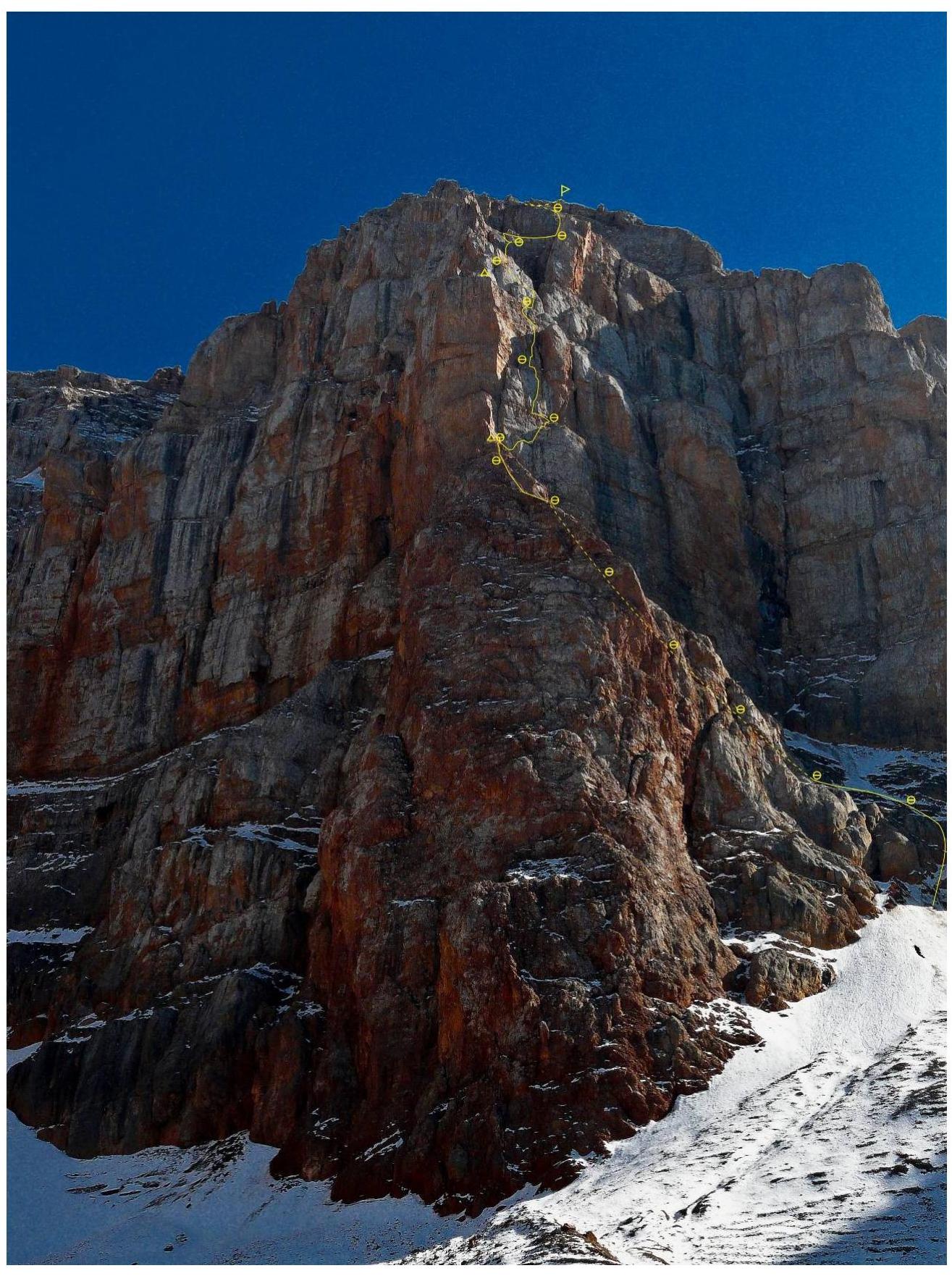
Route line
Photograph taken on August 23, 2013, at 15:04 from the moraine under the route.
| Pitch № | Length, m | Category of difficulty | Angle | UIAA symbol diagram |
|---|---|---|---|---|
| R17–R18 | 400 | II | 30° | |
| R16–R17 | 50 | III+ | 70° | |
| R15–R16 | 50 | II | 22° | |
| R14–R15 | 50 | V | 80° | |
| R13–R14 | 50 | IV+ | 75° | |
| R12–R13 | 50 | V | 90° | |
| R11–R12 | 50 | V | 80° | |
| R10–R11 | 50 | IV | 75° | |
| R9–R10 | 10 | III+ | 70° | |
| R8–R9 | 50 | III | 75° | |
| R7–R8 | 50 | II+ | 60° | |
| R6–R7 | 50 | II | 55° | |
| R5–R6 | 50 | II | 56° | |
| R4–R5 | 50 | II+ | 45° | |
| R3–R4 | 50 | II | 40° | |
| R2–R3 | 50 | IV | 70° | |
| R1–R2 | 50 | IV | 65° | |
| R0–R1 | 300 | II– | 30° |
UIAA symbol diagram of the route
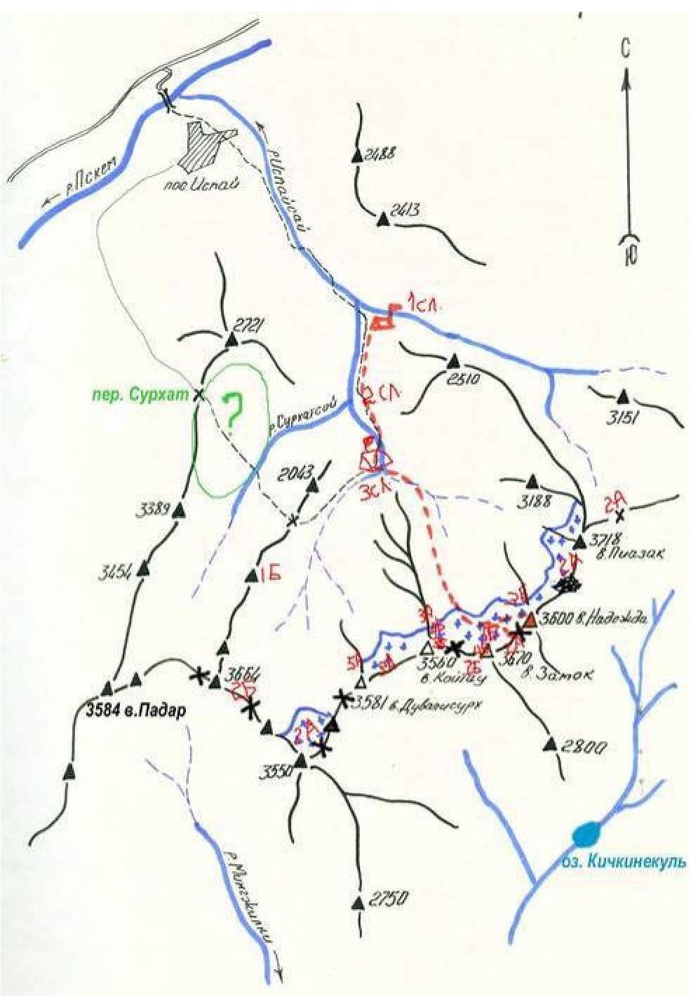
Map — diagram of the area (Pskem Ridge)
Recommended equipment for a group of 3:
Main rope 50–60 m — 2 pcs, Quickdraws — 10 pcs, Rock hammers — 2 pcs, Pitons:
- anchor — 1 pc
- U-shaped — 2 pcs
- other — 6 pcs, "Sail" type protection — 1 set (10 pcs), Friends — 1 set (12 pcs), e-mail: alpinistory@gmail.com
Comments
Sign in to leave a comment