Duvalisurkh (3580) via the left North Ridge — 5A (rock)
Climbing passport:
- Western Tian Shan, Pskem Ridge, section #7.14 according to the 2013 classifier
- Duvalisurkh peak (3580 m) via the left North Ridge (l. N. r.).
- 5A category of difficulty
- First ascent: Kanonersov V. — Khursandov A. (1982)
- Description update: Shekhovtsov S., Makhmudov U., Mayorova L. (2013)
Route description:
From the base camp near the springs under Duvalisurkh peak to the col of the North ridge, the ascent takes 1.5–2 hours via scree or snow.
From the col:
- Move upwards under the wall along the scree slope — 200 m.
Start of the route. Further movement is upwards through a system of inclined shelves alternating with short, not difficult walls. 50 m. Further, the wall turns into a counterfortress with a steepness of 30°. The rocks of the counterfortress are heavily destroyed. Behind the counterfortress, there is a simple couloir going to the right and upwards. In the absence of snow, the couloir can be stone-dangerous. After 50 m of simple climbing, the couloir leads to a short wide ridge.
After 30 m of simple climbing, the ridge leads to a wide (3 m) shelf under the wall. Move along the shelf to the left — 20 m. Here is the first control point.
First crux: from the control point, move upwards through a narrow chimney, slightly inclined to the right.
- The first 10 m of the chimney are steep — complex climbing with the use of primitive ITC (Intermediate Technical Climbing).
- Further, the relief becomes more gentle, the chimney becomes stone-dangerous above, so move slightly to the right.
- 40 m of complex climbing on "live" terrain lead to a shelf with a reliable "balda" (anchor) for a belay station.
Further, move straight up, and after 15 m, slightly to the right along a not well-defined shelf. Climbing is of medium difficulty. The wall ends with a system of scree shelves.
Further movement is along the shelves and simple rocks for 100 m until a rock "pillar" 10 m high.
Second crux: ascend in a squeeze between the wall and the "pillar", then — from a small platform at the top of the "pillar", move to the wall and climb it to the right and upwards. After 50 m of complex climbing, the relief becomes more gentle.
From here, move along simple rocks for 20 m under an overhanging gendarme. Third crux: pass the gendarme on the left. 50 m of complex climbing. In the lower part of the gendarme, there is a short overhanging section with a small number of holds — 6 m, 95° — climb with the use of simple ITC or with a lift for the leader. Further, the relief becomes more gentle and easier. Move along the left part of the inner corner, which becomes vertical at the top and abuts an overhang. The overhang is bypassed on the left. After the overhang — a short scree slope leading to a shelf. On the shelf — the second control point.
After 40 m of simple rocks, exit onto the summit dome. The ascent to the summit is along snow or scree — 80 m.
Descent:
- Along the western ridge to the pass, then along the trail
- Or along a wide scree couloir, not reaching the pass
The descent to the base camp takes 1 hour.
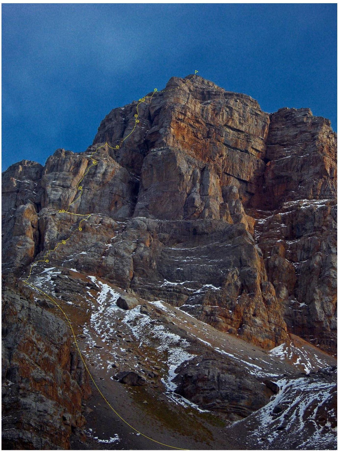
Route line
Photo taken on September 20, 2013, at 16:17 from the moraine under the route.
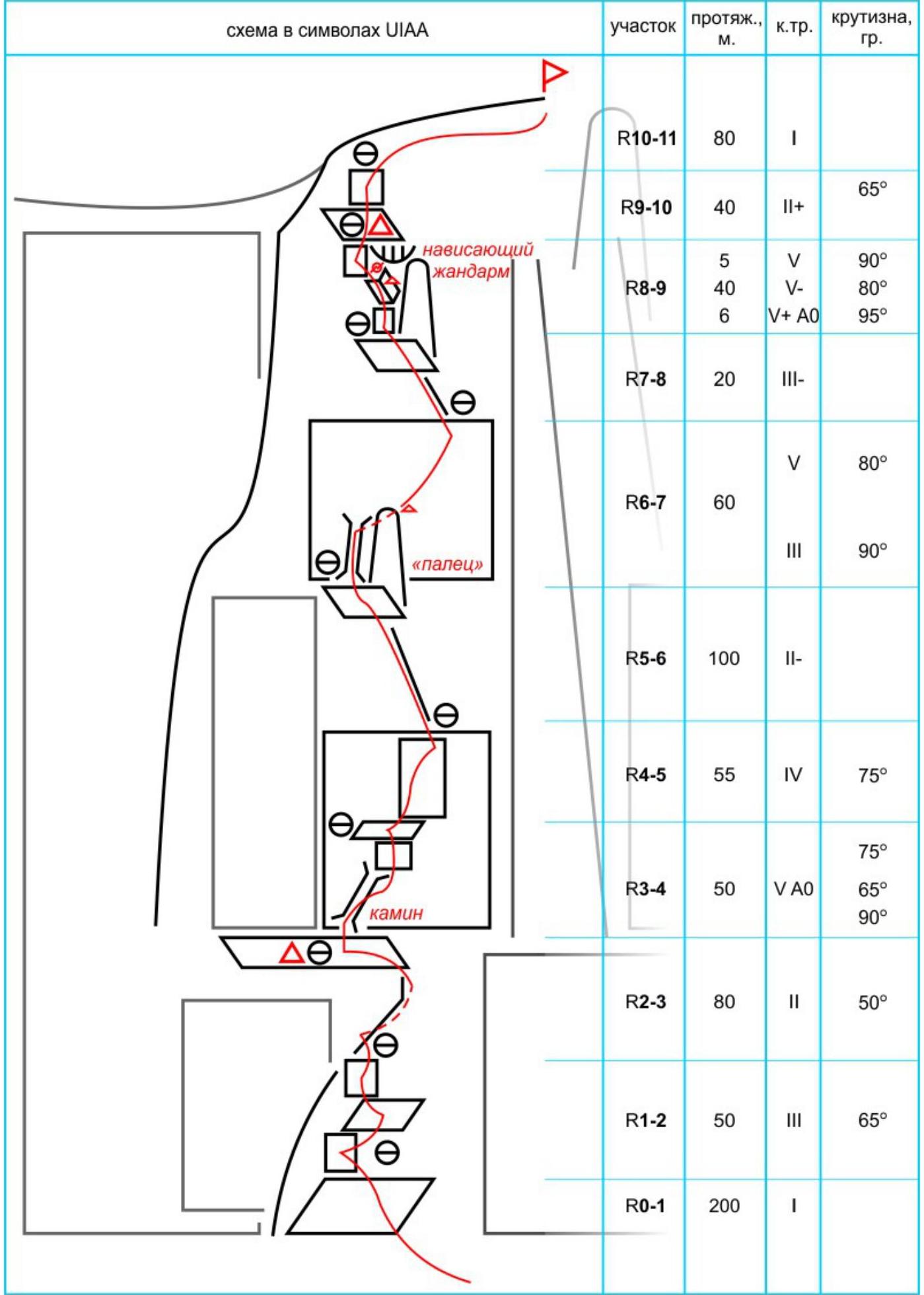
Route scheme in symbols
UIAA
Map-scheme of the area (Pskem Ridge)
Recommended equipment for a group of 3 people:
- Main rope 50–60 m — 2 pcs
- Quickdraws — 10 pcs, including slings or ladders — 1 pc
- Rock hammers — 2 pcs
- Pitons: anchor — 3 pcs, U-shaped — 3 pcs, other — 6 pcs
- "Sail" type protection — 1 set (10 pcs)
- Friends — 1 set (12 pcs) e-mail: alpinistory@gmail.com