
7.14.17
Mt. Teke (3870 m)
(via the left, eastern edge — cat. 3A) (from the "Nefertiti" campsite — 2866 m)
From the "Nefertiti" campsite, cross the stream to the other side and begin ascending via a wide couloir between the massive rocky edges of the massif. A prominent gendarme in the upper part of the edge, resembling the walls of the "Bastille" fortress, serves as a landmark. This edge remains to the right of our couloir.
The ascent up the snowy (and later, debris-covered) couloir takes about 2.5 hours. Past a rocky outcrop in the middle of the couloir, with 15-meter walls and forming a shoulder at the top, ascend 200–250 m up the slope to reach the ridge at the level of the gendarme — a tower of very regular shape. This marks the beginning of the route. All gendarmes and rocky walls encountered along the ridge can generally be bypassed on the left.
- Movement along the left part of the ridge is via rocky ledges, with intermittent belaying; the difficulty of the sections is cat. II–III, up to 200–220 m.
- In the final third of the route, there is a 40-m ascent onto a gendarme via cat. III rocks.
- This is followed by a descent onto a 2–3 m wide, 30-m long saddle with a depth of up to 10–12 m. Snow cornices overhang. Belaying is thorough.
- From this point begins a fairly steep snowy ascent with individual rocky outcrops, stretching up to 100 m, with an initial slope of 45° increasing to 75°. Belaying is via ice axe, and later via pitons. The entire rocky cliff of the pre-summit triangle remains to the left.
- Then follows a long, approximately 200-m ascent onto the snow-covered summit ridge (watershed).
- The summit cairn is located in the northern part of the ridge (to the right of the route), about 400–450 m away.
- The ridge leading to the summit is heavily fragmented. Move along the left side, with simultaneous belaying.
- The South-Western slope features a calm scree.
- The cairn, where the note is kept, is next to a trig point installed by geodesists.
- Descent is to the left (orographically) of the left ridge, cat. 2B, down a snowy couloir to the camp, taking 30–40 minutes.
The entire route from campsite to campsite takes 9–10 hours.
The first ascent was made on May 5, 1980, by a duo of climbers from the USSR Sports Committee:
- Mukanova K.B.
- Prokopiev V.V.
Recommendations for climbers:
- Number of participants — 6 people
- Initial bivouac — "Nefertiti" campsite — 2866 m
- Departure from the bivouac no later than 6:00 AM
- Equipment for the group: main rope 3×30/40 m, rock hammers — 2 pcs. Pitons: rock (various) — 8–10 pcs., ice 2–3 pcs.
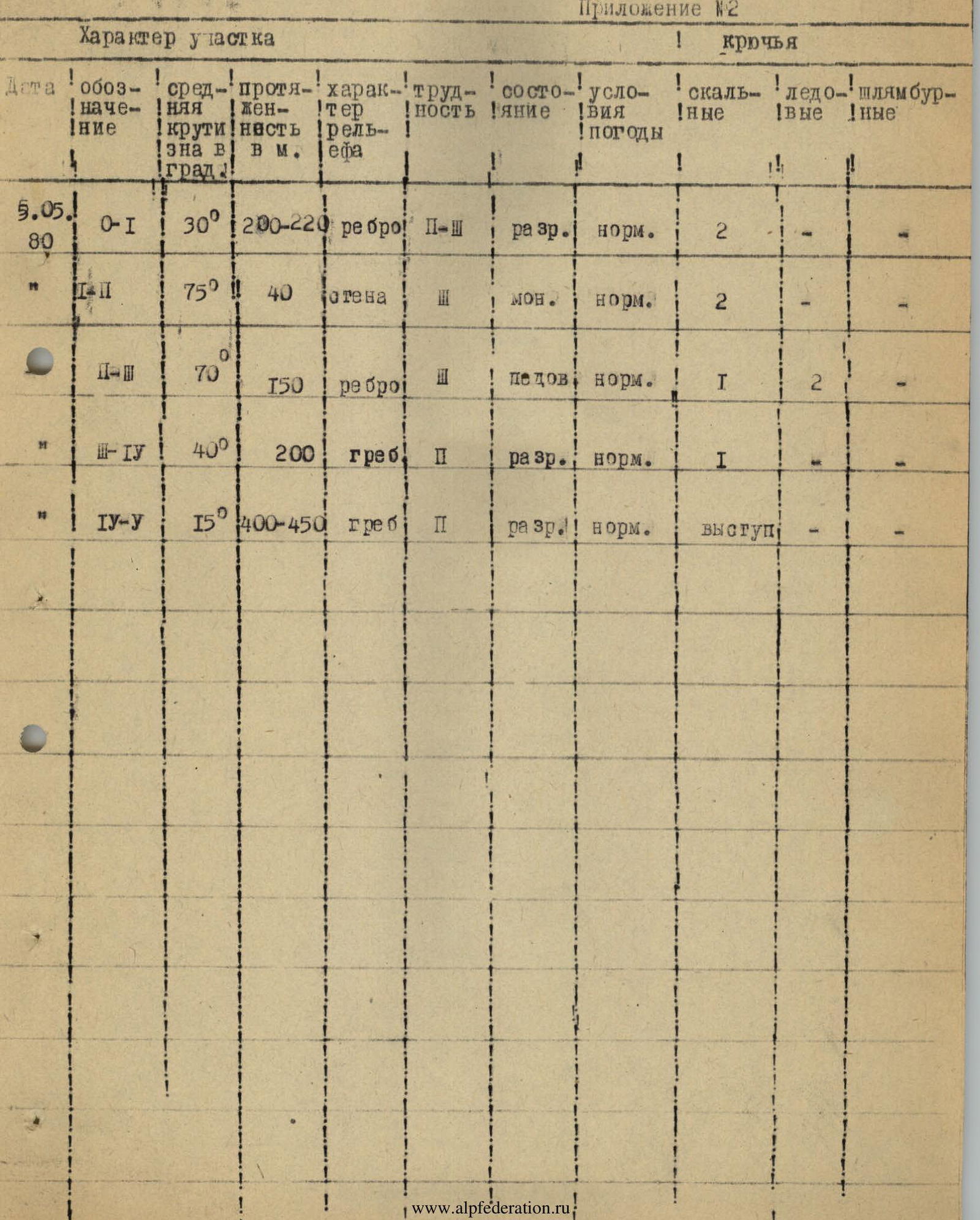
Appendix №2
Characteristics of Sections
| Date | Section | Average steepness | Length | Nature of terrain | Difficulty | Condition | Weather conditions | Rock pitons | Ice pitons | Other pitons |
|---|---|---|---|---|---|---|---|---|---|---|
| 05.05.1980 | R0 | 30° | 200–220 m | edge | II–III | fragmented | normal | 2 | — | — |
| R1 | 75° | 40 m | wall | III | monolithic | normal | 2 | — | — | |
| R2 | 70° | 150 m | edge | III | icy | normal | 1 | 2 | — | |
| R3 | 40° | 200 m | ridge | II | fragmented | normal | 1 | — | — | |
| R4 | 15° | 400–450 m | ridge | II | fragmented | normal | outcrop | — | — |
Comments
Sign in to leave a comment