
I. ASCENT LOG
- Ascent class — technical
- Ascent area, range — North Tian Shan, Talas Range
- Peak, its height, ascent route — Yuzhny Manas, 4512 m, via the center of the north face of the eastern ridge
- Proposed difficulty category — 5B
- Route characteristics: height difference — 1000 m, length of sections with 5-6 technical difficulty, 537 m, average steepness — ~75°
- Pitons used: for belaying — rock 116, ice and bolt —; for creating artificial anchors: rock — 25, ice and bolt —
- Number of climbing hours — 30
- Number of bivouacs and their characteristics: two bivouacs: on the wall — semi-reclining for two; on the eastern ridge — good reclining
- Surname, name, patronymic of the leader, participants, and their qualification: pair — KRAPIVIN V.N., CMS; PARSHIN V.S., CMS
- Team coach: Troshchinenko L.A., Master of Sports of the USSR
- Dates of departure and return: May 5, 1981 – May 8, 1981
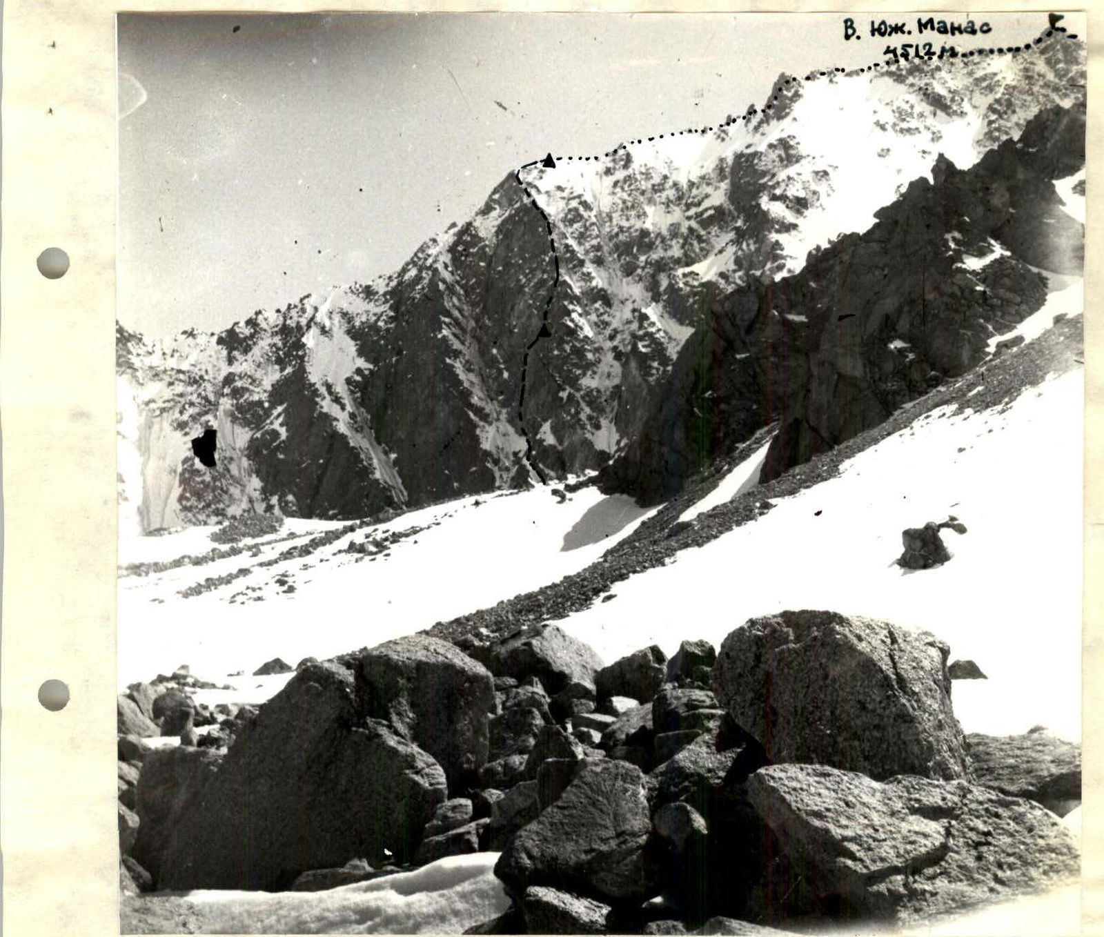
Fig. 1. View of the north face of the eastern ridge of Yuzhny Manas
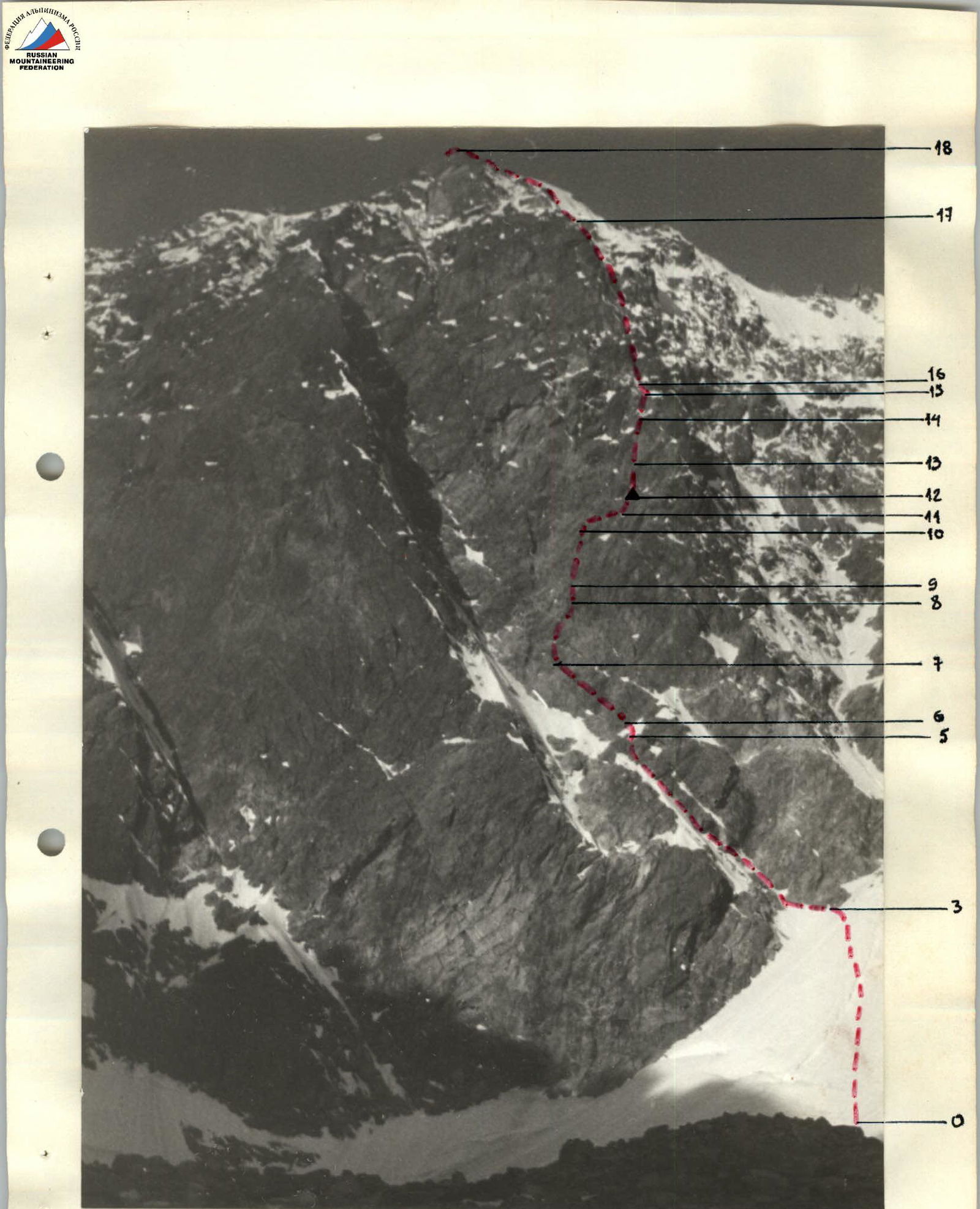
Fig. 2. Photograph of the wall section of the ascent route
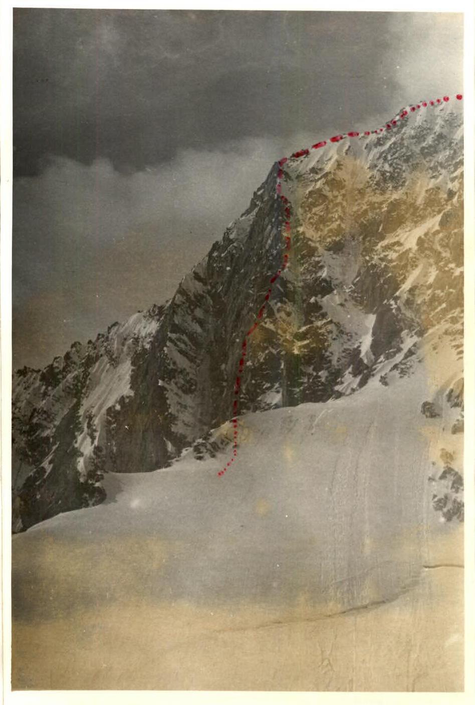
Fig. 3. Photograph of the profile of the wall section of the ascent route
III. Brief description of the approach to the ascent route on Yuzhny Manas (4512 m) via the center of the north face of the eastern ridge (5B category)
From the "Mazar" base camp, 3-3.5 hours of walking uphill along the trail to the "May" campsite under the slope of Manas. Elevation mark of the campsite according to the altimeter is 3300 m.
From the "May" campsite, 1.5-2.0 hours uphill along the moraine to the north face of the eastern ridge of Yuzhny Manas.
Location of the assault camp. The object of the ascent is the black rock wall dominating the center of the north slope of the eastern ridge, with a characteristic rock-ice couloir dividing the wall from left to right downwards into two parts.
The ascent route passes through the center of the right part (see Fig. 1, 2).
IV. Table of main characteristics of the ascent route
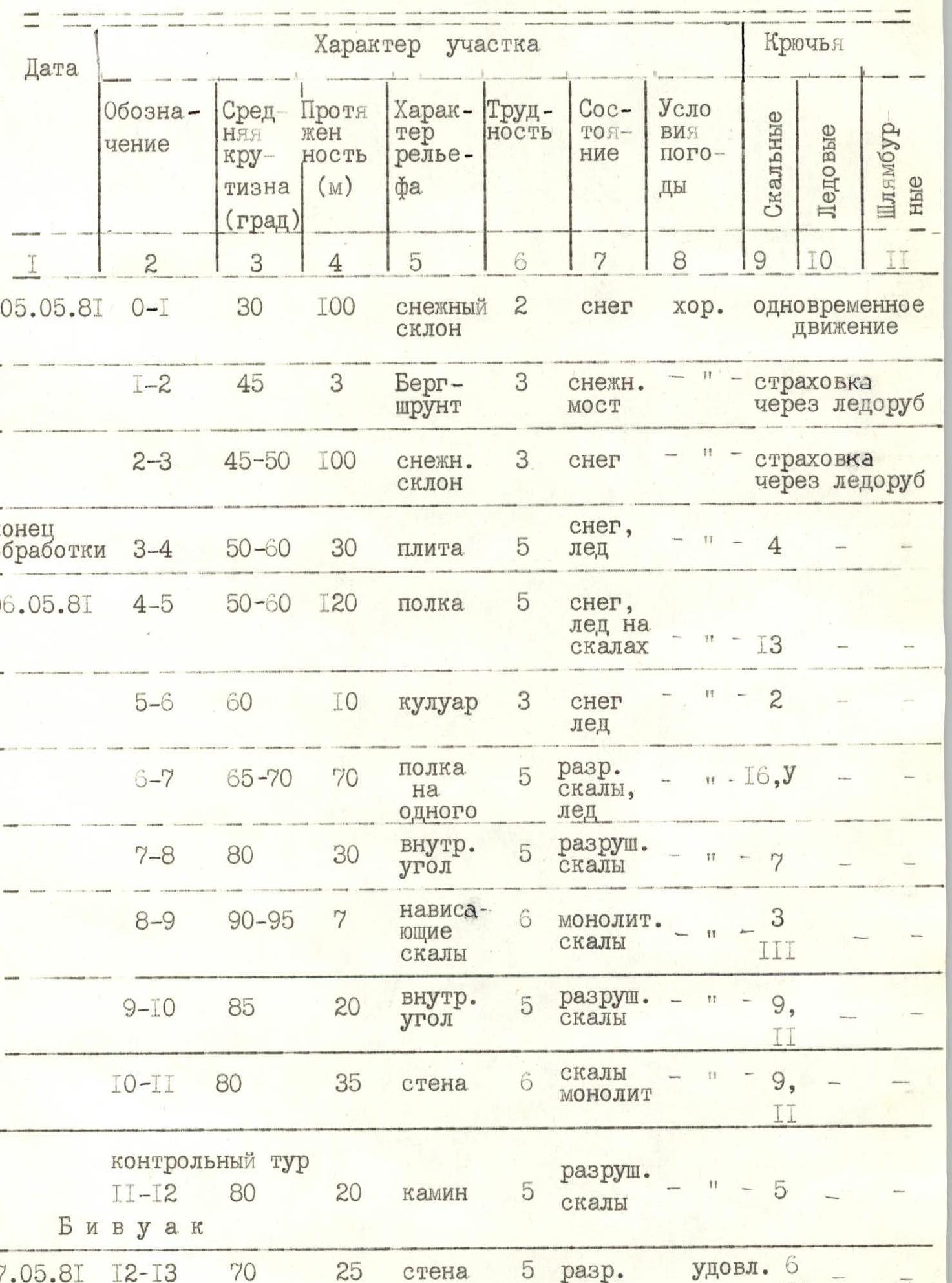
| Date | Section designation | Average steepness (degrees) | Length (m) | Terrain characteristics | Difficulty | Condition | Weather conditions | Pitons: rock | Pitons: ice | Pitons: bolt |
|---|---|---|---|---|---|---|---|---|---|---|
| 05.05.81 | R0–R1 | 30 | 100 | snow slope | 2 | snow | good | simultaneous movement | ||
| R1–R2 | 45 | 3 | bergschrund | 3 | snow bridge | belay through ice axe | ||||
| R2–R3 | 45–50 | 100 | snow slope | 3 | snow | belay through ice axe | ||||
| end of | R3–R4 | 50–60 | 30 | slab | 5 | snow, ice | 4 | |||
| processing | ||||||||||
| 06.05.81 | R4–R5 | 50–60 | 120 | ledge | 5 | snow, ice on rocks | 13 | |||
| R5–R6 | 60 | 10 | couloir | 3 | snow, ice | 2 | ||||
| R6–R7 | 65–70 | 70 | narrow ledge for one | 5 | broken rocks, ice | 16, U | ||||
| R7–R8 | 80 | 30 | internal angle | 5 | broken rocks | 7 | ||||
| R8–R9 | 90–95 | 7 | overhanging rocks | 6 | monolithic rocks | 3 | 3 | |||
| R9–R10 | 85 | 20 | internal angle | 5 | broken rocks | 9 | 2 | |||
| R10–R11 | 80 | 35 | wall | 6 | rocks, monolith | 9 | 2 | |||
| control | R11–R12 | 80 | 20 | chimney | 5 | broken rocks | 5 | |||
| cairn bivouac | ||||||||||
| 07.05.81 | R12–R13 | 70 | 25 | wall | 5 | broken | satisfactory | 6 | 2 | |
| R13–R14 | 80 | 50 | internal angle | 5 | broken rocks | satisfactory | 12 | 2 | ||
| R14–R15 | 80 | 20 | chimney with a plug | 5–6 | broken rocks | 6 | 3 | |||
| R15–R16 | 40 | 20 | snow ridge | 4 | snow | 2 | ||||
| R16–R17 | 70 | 110 | right edge of the wall | 5–6 | flow ice | 30 | U | |||
| R17–R18 | 40–45 | 120 | snow edge | 4 | snow on ice | 10 | ||||
| bivouac | ||||||||||
| 08.05.81 | R18–R19 | 25–30 | 200 | snow ridge | 2 | snow | poor | simultaneous movement | ||
| R19–R20 | 50 | 50 | snow ridge | 3 | snow | belay through ice axe | ||||
| R20–R21 | 60 | 10 | couloir | 4 | flow ice | 2 | 0 | 0 | ||
| R21–R22 | 90 | 200 | ridge | 3 | broken rocks | ledges | ||||
| R22–R23 | 45 | 200 | ridge | 4 | broken rocks | 5 ledges | ||||
| R23–R24 | 60–70 | 120 | wall | 4 | monolith | 12 ledges | ||||
| R24–R25 | 30 | 220 | ridge | 2 | broken rocks | simultaneous movement | ||||
| R25–R26 | 80 | 20 | wall | 4 | monolith | rappel with jerking | ||||
| R26–R27 | 40 | 80 | ridge | 3 | broken rocks | ledges |
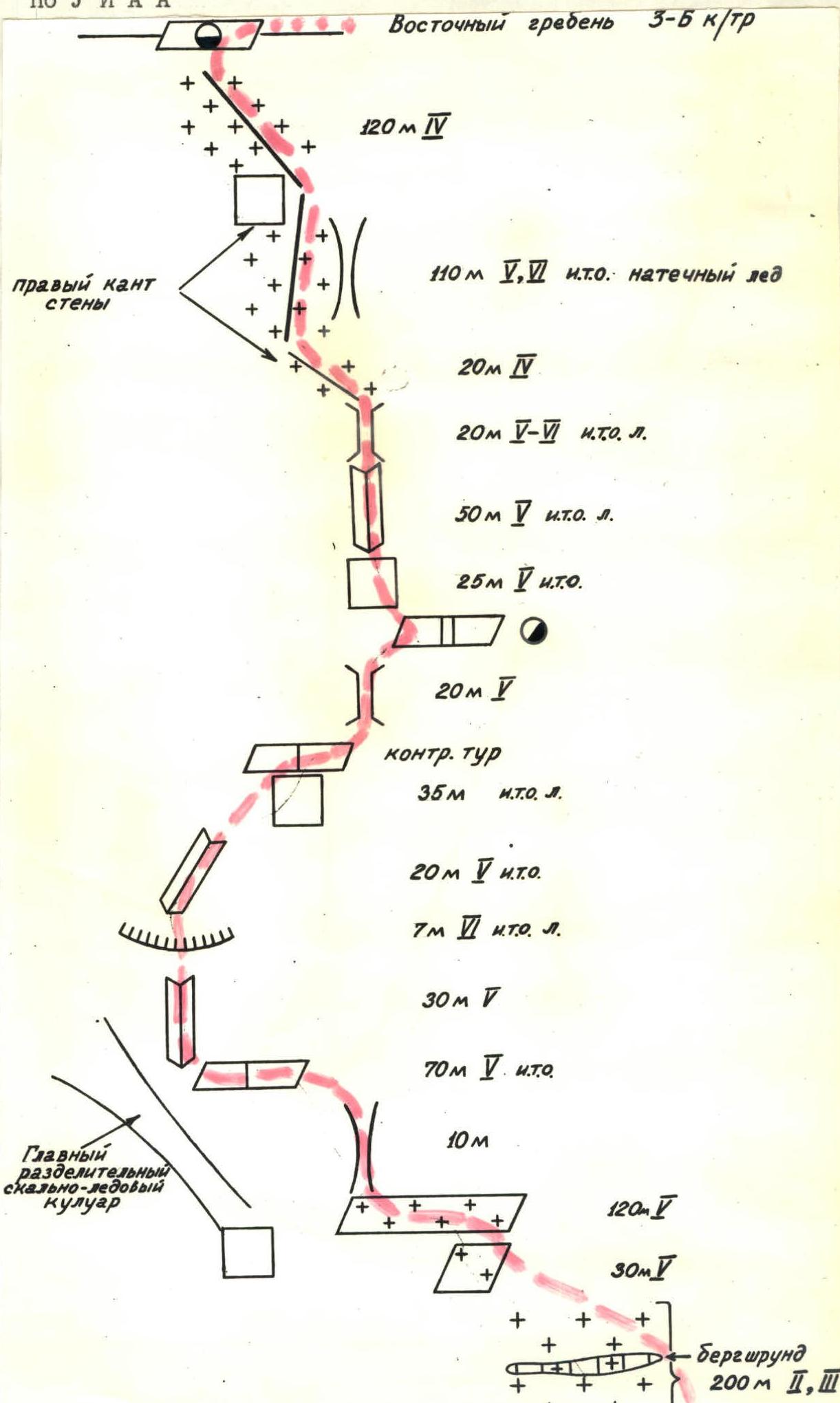
V. Brief explanation of the table of main characteristics of the ascent route
Sect. R0–R3. In the first half of summer, it is traversed on snow. Later, in the area of the bergschrund and above, ice may appear. Crossing the bergschrund is preferable to the right.
Sect. R3–R6. Movement on the slab and ledge covered with snow (ice) with piton belay. Pitons are driven into the rocks to the right.
Sect. R6–R7. Crossing a small couloir with flow ice, exit to the right wall. Further movement is along a clearly defined narrow inclined ledge under the overhanging rocks on the right, leading upwards to the right and left. The large couloir, where rockfall is possible, remains below on the left.
Sect. R7–R10. Movement straight up in the direction of the rusty-colored rock standing out in the upper part of the right edge of the wall. Movement is along heavily dissected and smoothed rocks. Special attention should be paid to the choice of belay points and means:
- using chocks is impractical due to the large number of "loose" rocks and the blocky structure of the rocks;
- blade pitons are used predominantly.
Key point — overhanging rocks on the section R8–R9. After sect. R8–R9, start traversing the wall to the right (sect. R10–R11).
Sect. R10–R11. Very difficult climbing on smoothed rocks. There are few places to drive pitons. At the end — traverse, narrow ledge with a control cairn.
Sect. R11–R12. After overcoming the chimney to the right and upwards (20 m), a bivouac is possible on a ledge for two. Overnight stay for two or more teams is possible only separately. Before this, there are no convenient bivouac sites on the wall.
Sect. R12–R15. From the bivouac site — traverse along the ledge to the left under the internal angle, ending in a chimney, leading to the right edge of the wall above the rusty-colored rock standing out on the edge. Good bivouac site.
Sect. R15–R17. After overcoming the sharp snow ridge, movement is along the edge of the wall, leaving the rock-ice groove on the right. Movement is on rocks with flow ice.
Sect. R17–R18. Movement is along a steep snow edge with piton belay on rock islands. In the second half of summer, ice sections are possible.
After reaching the eastern ridge, movement follows the 3B category route.
VI. Schematic designation of the wall section of the route according to UIAA
Comments
Sign in to leave a comment