PASSPORT
- Rock class
- Western Tien Shan, Chatkal Ridge, Kara-Tako gorge
- Peak "4170" via the northeastern wall
- Proposed - 5B cat. sl. first ascent
- Elevation gain: 900 m, length - 1335 m.
Wall section elevation gain - 750 m, length - 985 m. Length of sections with 5–6 cat. sl. - 494 m. Average steepness of the main part of the route - 67° (3270–4020), including 6 cat. sl.: 95–100° (3350–3370); 80–110° (3390–3420); 75° (3525–3600); 70–90° (3635–3670); 105° (3835–3840).
- Pitons driven:
| Rock Pitons | Nuts | Bolts |
|---|---|---|
| 44 | 132 | 2 |
| 4 | 6 | 1 |
-
Team's walking hours: 23 h 45 min and days - 3
-
Night bivouacs: 1 — sitting, carved on a snow-ice ridge, 2 — lying on the ridge.
-
Leader: Kotelnikov Anatoly Ivanovich MS
participants:
- An Pavel Valentinovich CMS
- Krakov Boris Grigorievich CMS
- Rakhmatullaev Konstantin Kasimovich CMS
- Selyaev Viktor Viktorovich CMS
- Shanin Anatoly Gennadievich CMS
-
Coach: Voronin Vyacheslav Tikhonovich MS
-
Approach to the route: July 14, 1988. Summit — July 16, 1988. Return — July 16, 1988.
-
Goskomsport UzSSR
July 16, 1988
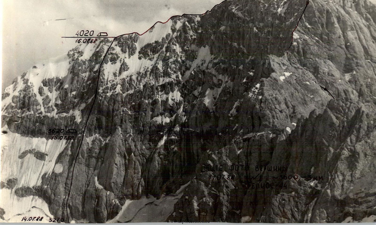
PROFILE OF THE WALL FROM THE RIGHT. А — cat. sl. — bivouac. July 13, 1988, Industar-50b, t. №3, 800 m, ~3250.
PROFILE OF THE WALL FROM THE LEFT — k.tur, — bivouac. July 13, 1988, Industar-50, t. №4, 500 m, 3400.
PROFILE OF THE ROUTE ON p. 4170 via the NE wall 5B cat. sl. (approximately).
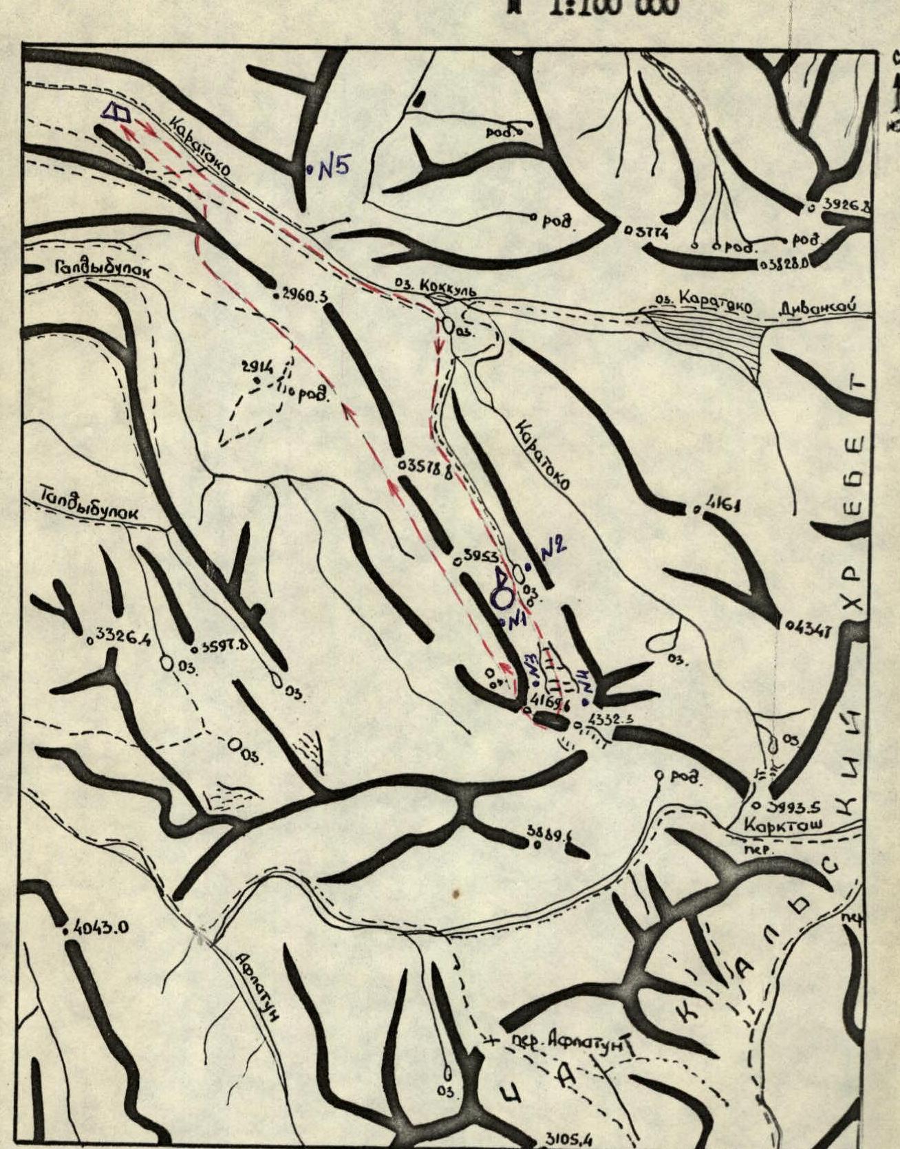
 Map of the ascent area. M 1:100 000.
Symbols:
- base camp
- assault camp
- ascent route
- route
Overview of the Ascent Area
Peak 4170 is located in the northwestern spur of the Chatkal Ridge, the highest in the Western Tien Shan. In the northeastern part of the ridge, where p. 4170 is located, the average height of the peaks is about 4000 m, slightly to the south — the highest part of the ridge with heights around 4500 m.
The Chatkal Ridge serves as a watershed between two large river basins:
- The northwestern slopes give rise to the Chatkal River, which flows into the Charvak reservoir near Tashkent;
- The southeastern slopes, facing the Fergana Valley, feed the tributaries of the large Naryn and Syr-Darya rivers.
The Chatkal River valley can be reached by several paths:
- from the south — through the passes in the Chatkal Ridge, of which the most famous are the pack passes Chanch and Aflatun and the automobile pass Chapchama;
- from the north — through the Talassky Ridge, a highway is laid from Dzhambul through the Karabura pass;
- to the east — in the upper reaches of Chatkal — the pack pass Kara-Kuldzha;
- and finally, from the west from the village of Brich-Mulla along the Chatkal valley there is a well-trodden trail.
In the summer of 1945 and 1950, expeditions of climbers from the "Nauka" sports society with the participation of E.A. Kazakova visited Chatkal. These expeditions made 8 ascents in the central, highest part of the ridge (p. Chatkal - Baiga and others) in the upper reaches of the Arpa-Takty River, and surveyed the Kara-Tako River valley.
The team reached the ascent area from the Fergana Valley through the Chapchama pass and further along the Chatkal valley to the confluence with the Kara-Tako River.
Along the Kara-Tako River valley, you can drive a car 8–10 km. The road runs practically along the riverbed and abounds in fords, often quite deep.
The base camp was set up on the bank of the Kara-Tako River approximately in the lower third of the river's course. From here to Lake Kok-Kul is about 3 hours walk along a good trail. In the middle reaches, closer to Lake Kok-Kul:
- the river flows in a narrow rocky channel;
- the trail goes upstream through picturesque spruce forests.
The object of the ascent is located in the upper reaches of the leftmost tributary of Kara-Tako, which flows into the river in the area of Lake Kok-Kul. From the lake through a huge scree, bypassing the largest lakelet, we get on a trail leading through alpine meadows to the upper reaches of the tributary, originating from the glacier p. 4170 and two fairly large lakes located one after another immediately after the glacier. To the right of the path, the gorge is bounded by a sheer rock wall 100–300 m high, adjacent to the north wall of p. 4170. In the left part of the northeastern wall of p. 4170 — a rather powerful glaciation with a hanging glacier and a snow-ice bridge.
From Lake Kok-Kul to the assault camp between the two upper lakes — 2–3 hours walk.
Our team also explored the upper reaches of the right tributaries of Kara-Tako above Lake Kara-Tako and discovered interesting objects at altitudes of 4300–4700 m, which are also mentioned in the reports of E.A. Kazakova.
The combination of interesting climbing objects with a picturesque and diverse landscape makes this area attractive to climbers.

Photopanorama of the ascent area on July 11, 1988, t. №5, Industar-50, ~3000 m, 15 km.
Tactical Actions of the Team
The tactical plan was to pass the route with two night bivouacs:
- One on the wall
- The second on the ridge
In case of bad weather, an additional day of work on the route was provided.
The route was completed from July 14 to July 16, 1988, in full accordance with the tactical plan. The time taken to ascend was 23 h 45 min, descent from the summit to the glacier in the Western cirque took 8 h, and 3 h — through the gorge to the base camp.
The leaders on the route changed after 5–6 ropes of climbing, which contributed to:
- fast and safe passage of the route,
- the opportunity to rest, as the climbing is very intense.
The first person worked on the wall in galoshes and without a backpack. All team members were provided with double insurance. On the wall section of the route, the group's movement was carried out along the rope. The main principle when choosing a route and bivouac locations was safety.
July 14. The main task is to pass the lower rock bastion by the team to the section R17 and organize a night bivouac on the snow-ice ridge.
Challenging sections of the route:
- passage of cornices
- steep smooth slabs
- partially overhanging sections
The first to work is the bundle Kotelnikov A. — Selyaev V. Passed by free climbing, partially using artificial aids (ITO) 400 m of the wall. Night bivouac sitting in a tent. The task is completed.
July 15. At 8:45 the team leaves the bivouac. The task is to reach the ridge, where there is an opportunity to organize a good night bivouac.
Challenging sections:
- "Smooth, steep slabs like 'ram's foreheads' with minimal holds"
- "Cornice when exiting to the rib"
- "The rib itself, heavily destroyed, which requires climbers to be especially attentive and cautious"
The first to work is the bundle Shanin A. — An P. They work confidently and reliably. Smooth slabs are passed on friction, cornice with the use of ITO. When moving along the rib, the problems with organizing insurance points disappear — a large selection of cracks for nuts and friends. Several ropes of the route are passed by autonomous bundles.
The ridge is led out by a sharp snow rib. When exiting to the ridge, it was necessary to dig a trench in the snow more than 1 m deep, since the snow is dry and steps are not formed. At 17:20 they reached the ridge. After walking along the ridge about 120 m, they stopped for a night bivouac in a place well protected from the wind — a snow depression. Night bivouac is comfortable — lying down.
While the bivouac is being organized, a steep rock ascent on the ridge is processed (~100 m).
July 16, 1988. The main task of the day is to reach the summit and descend to the base camp. At 8:30, the bivouac is dismantled and work on the route begins. Each bundle works independently, interacting on insurance points. The ridge is heavily serrated, consists of a series of ascents and descents, although there is not much altitude gain to the summit. From 10:30 to 11:00, the entire team reached the summit.
Descent from the summit along the NW ridge to the second saddle on the ridge and then west along the snow couloir to the glacier of the Western cirque p. 4170. During the descent to the saddle, the following were laid:
- 5 forty-meter rappels
- 2 sports descents
The safety measures for passing the route were:
- High physical, technical, and psychological preparation of the team.
- Knowledge of the ascent area and route relief, due to which the right choice of equipment and a tactical plan was made, which was fully maintained.
- Presence under the route of a qualified observation group and rescue team.
- Presence of constant and stable radio communication and visual observation.
- Presence of two hot meals and a pocket ration. Nutrition was based on 400 g of dry weight per person per day.
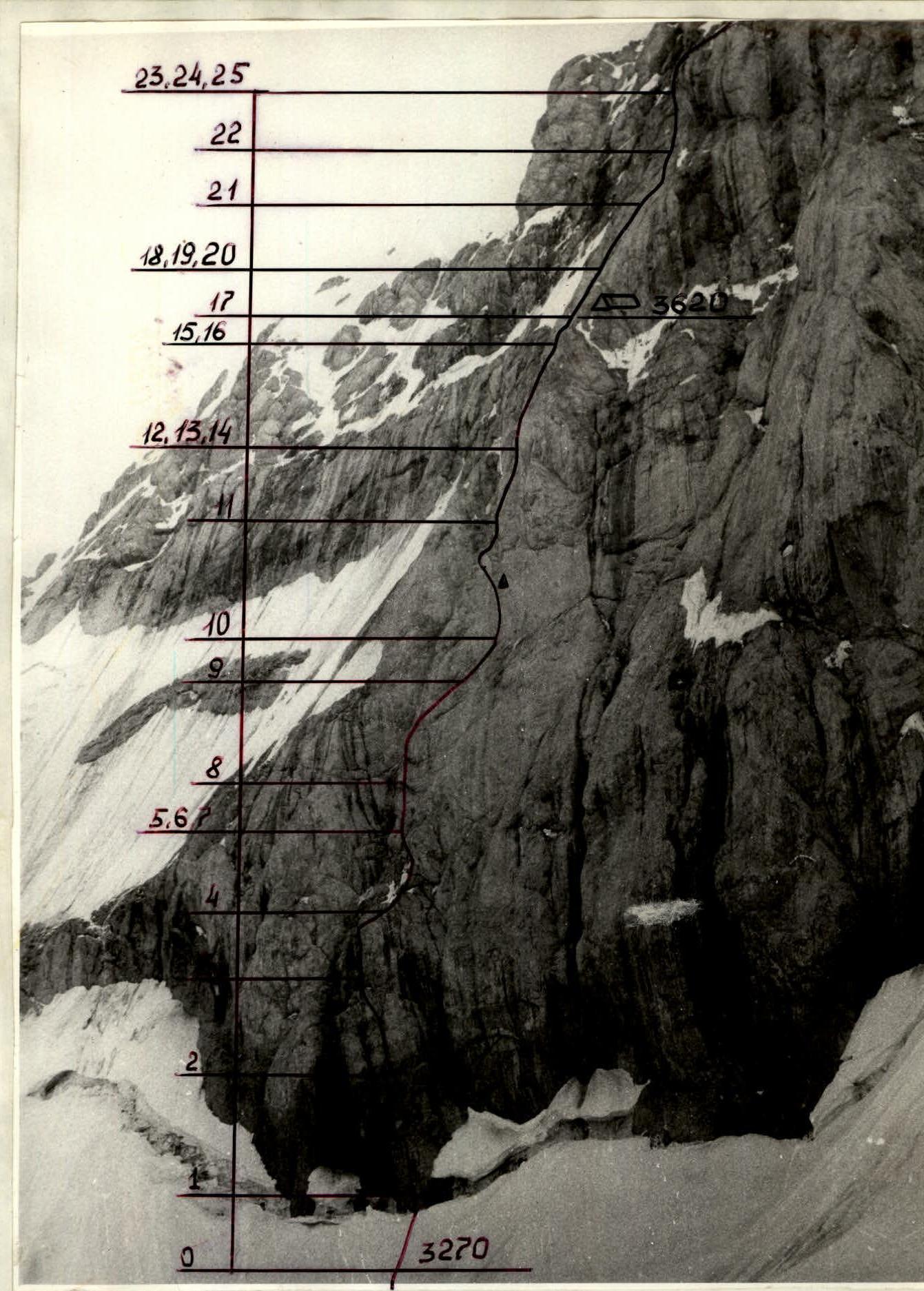
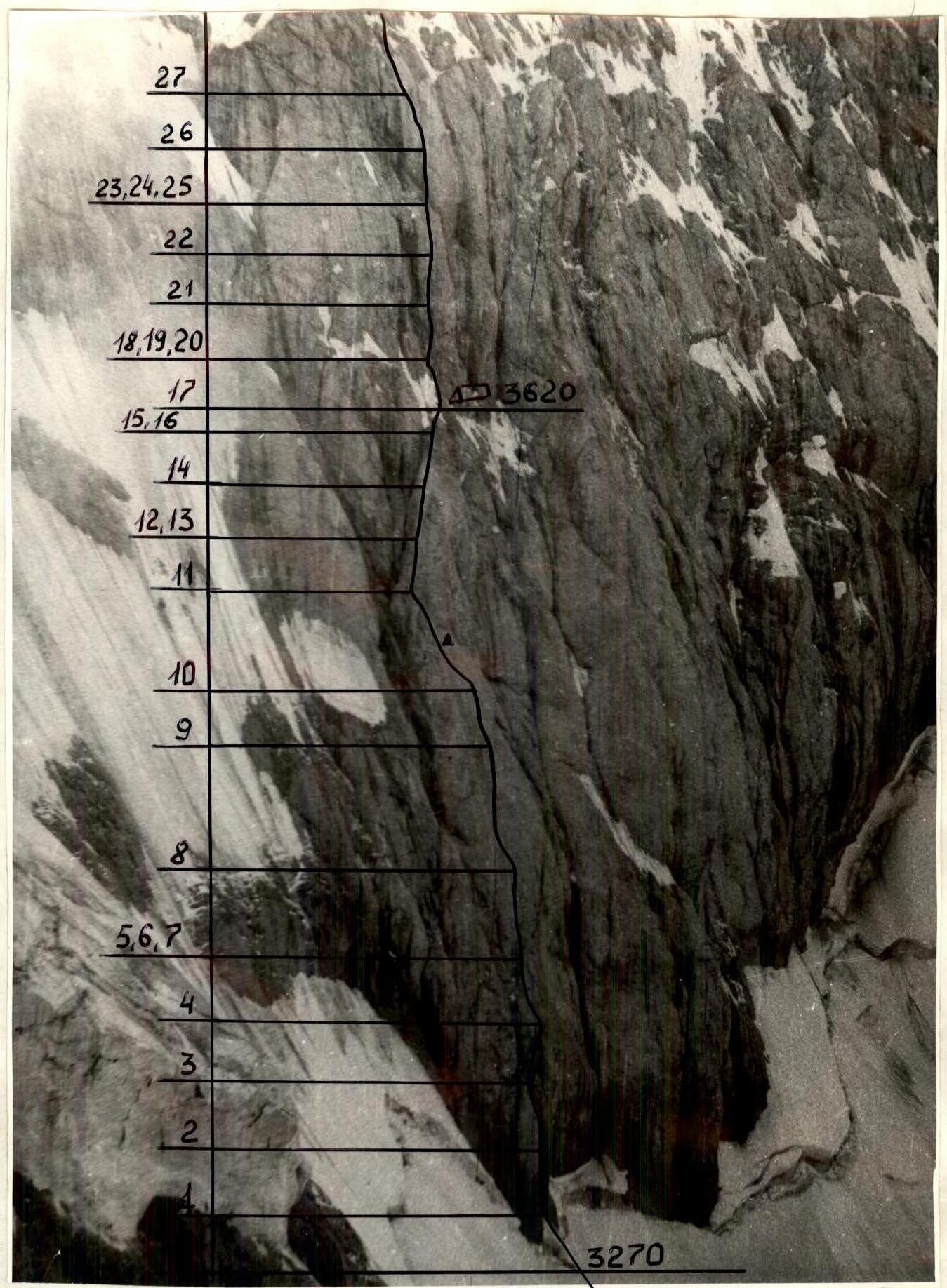
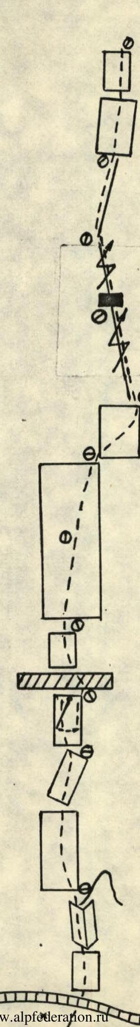
Scheme of the route in UIAA symbols
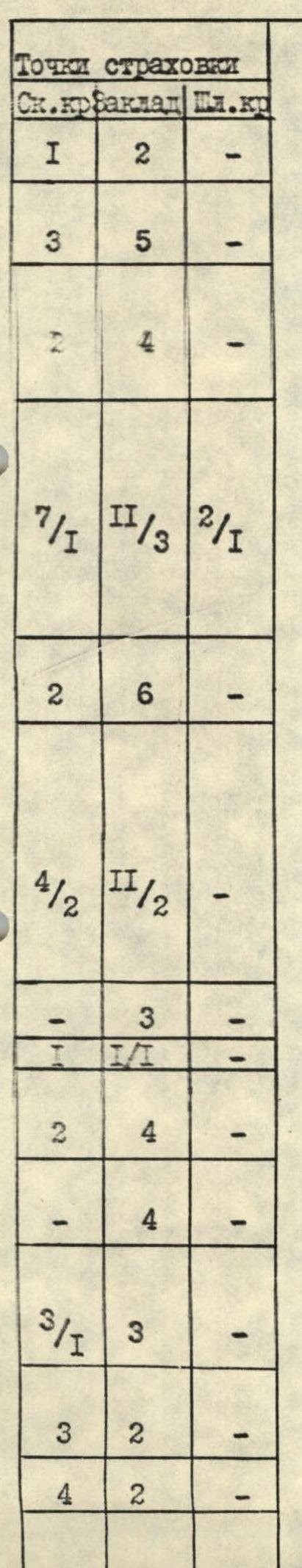
| Rock Pitons | Nuts | Bolts | Section № | Length (m) | Steepness (degrees) | Cat. sl. |
|---|---|---|---|---|---|---|
| 1 | 2 | - | R1 | 20 | 80 | V+ |
| 2 | 7 | - | R2 | 20 | 75 | V |
| 3/1 | 3 | - | R3 | 20 | 100 | 6 A3 |
| - | 4 | - | R4 | 25 | 60 | 4 |
| 2 | 4 | - | R5 | 25 | 80 | 6 |
| 1 | 1/1 | - | R6 | 5 | 110 | 6 A2 |
| - | 3 | - | R7 | 10 | 85 | 6 |
| 4/2 | II/2 | - | R8 | 80 | 75 | V+ |
| 2 | 6 | - | R9 | 35 | 75 | V |
| 7/1 | II/3 | 2/1 | R10 | 80 | 75 | 6 A2 |
| 1 | 4 | - | R11 | 40 | 80 | V+ |
| 2 | 4 | - | R12 | 25 | 70 | 6 A4 |
| 1 | 2 | - | R13 | 10 | 90 | 6 |
| - | 4 | - | R14 | 20 | 60 | 4 |
| - | 4 | - | R15 | 10 | 30 | 2 |
| - | 1 | - | R16 | 10 | 50 | 3 |
| - | - | - | R17 | 30 | 70 | V+ |
| 1 | 5 | - | R18 | 15 | 50 | 4 |
| - | 4 | - | R19 | 10 | 75 | V |
| 1 | 2 | - | R20 | 15 | 55 | 4 |
| - | 2 | - | R21 | 40 | 65 | V |
| 1 | 5 | - | R22 | 40 | 60 | 4 |
| - | 2 | - | R23 | 10 | 60 | 4 |
| 1 | 1 | - | R24 | 4 | 105 | 6 A2 |
| 1 | 1 | - | R25 | 25 | 60 | 4 |
| 1 | 2 | - | R26 | 40 | 80 | V+ |
| 3 | 5 | - | R27 | 80 | 55 | 4 |
| - | 8 | - | R28 | 80 | 60 | 4 |
| 1 | 8 | - | R29 | 70 | 50 | 4 |
| 2 | 7 | - | R30 | 40 | 50 | 4 |
| - | 2 | - | R31 | 350 | 20–50 | II–V |
| 1 | 15 | - | R32 | - | - | - |
Section R0–R1: Steep snow slope to the bergschrund, which adjoins the wall and is passed along a bridge. 50 m, 50°, 2. R1–R2: Steep monolithic wall with a small number of cracks. 20 m, 80°, V+. R2–R3: Inner corner leading to a flake. 20 m, 75°, V. R3–R4: Steep wall with an overhang in the lower part. Passed on the left side. 20 m, 95–100°, 6. R4–R5: Smoothed slab with a small number of holds. 25 m, 60°, 4. R5–R6: Wall with virtually no holds. In the upper part, a pendulum to the right. 25 m, 80°, 6. R6–R7: Cornice, rocks are destroyed. Extremely careful climbing. ITO. 5 m, 110°, 6 A2. R7–R8: Vertical smoothed slab. 10 m, 85°, 6. R8–R9: Slab, holds are smoothed, passed on friction. Difficult climbing. 80 m, 75°, V+. R9–R10: Traverse to the right and up towards the wall with a gap. 35 m, 75°, V. R10–R11: Wall with a gap, where only fingers fit. Movement to the left and up towards the rib. In the middle part, it is passed on ITO. Station is hanging. For organizing a station, a bolt is driven. 80 m, 75°, 6 A2. R11–R12: Rock rib leading under large rock slabs. 40 m, 80°, V+. R12–R13: Smooth slab, in the lower part passed on ITO. Nuts go into small cavities on the slab. 25 m, 70°, 6 A4. R13–R14: Steep wall, at the top overhanging. Rocks are heavily destroyed. 10 m, 90°, 6. R14–R15: Gentle rock rib, rocks are destroyed. 20 m, 60°, 4. R15–R16: Narrow shelf to the left of the snow-ice rib. There is a place for a sitting bivouac. 10 m, 30°, 2. R16–R17: Snow rib, on top ice. Passed in crampons or with step cutting. 10 m, 50°, 3. R17–R18: Smoothed slabs like "ram's foreheads". Organization of insurance points is problematic. Passed on friction. 30 m, 70°, V+. R18–R19: Inner corner turning into a crack. 15 m, 50°, 4. R19–R20: Crack, large friends and nuts go well. 10 m, 75°, V. R20–R21: Smooth slab resting against a cornice. Passed on the left side. 15 m, 55°, 4. R21–R22: Cornice, bypassed on the left, then along the left side of the slab. 40 m, 65°, V. R22–R24: Slab, there are destroyed areas. Approach to the next cornice. 50 m, 60°, 4. R24–R25: Four-meter cornice, passed in the middle part. 4 m, 105°, 6 A2. R25–R26: Slab with smoothed holds. Passed on friction. 25 m, 60°, 4. R26–R27: Along the inner corner — exit to the rib. Move, holding on to the right wall. There are "live" stones. 40 m, 80°, V+. R27–R30: Rock rib, rocks are heavily destroyed. 220 m, 50–60°, 4. R30–R31: Snow rib leading to the NE ridge. Dry snow, at the top a trench is dug for passage. Be careful, can trigger an avalanche. 40 m, 50°, 4. R31–R32: Heavily serrated ridge with dips, from the second dip — exit to the ridge on the right along a steep wall. After the wall — along the snow slope to the summit. 350 m, 20–80°, II–V.
Descent: along the NW ridge to the second saddle of the ridge. The ridge is rocky, steep, during the descent:
- 5 rappels
- 2 descents by sports method.
From the saddle to the west along the snow couloir into the Western cirque p. 4170 and along a gentle glacier, and then along the gorge back to the base camp on the Kara-Tako River.
Team Captain Kotelnikov A.I.
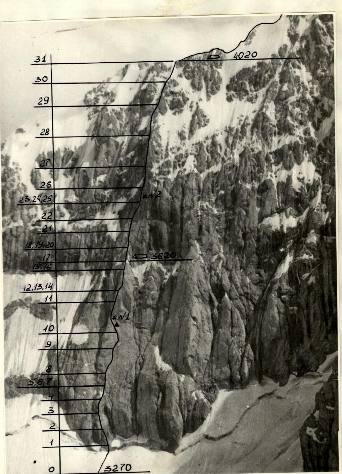
Technical photo of the route (1). — bivouac, — k.tur, *N — shooting locations. July 11, 1988, t. №1, H ~3600 m, ~3 km, Helios-44.
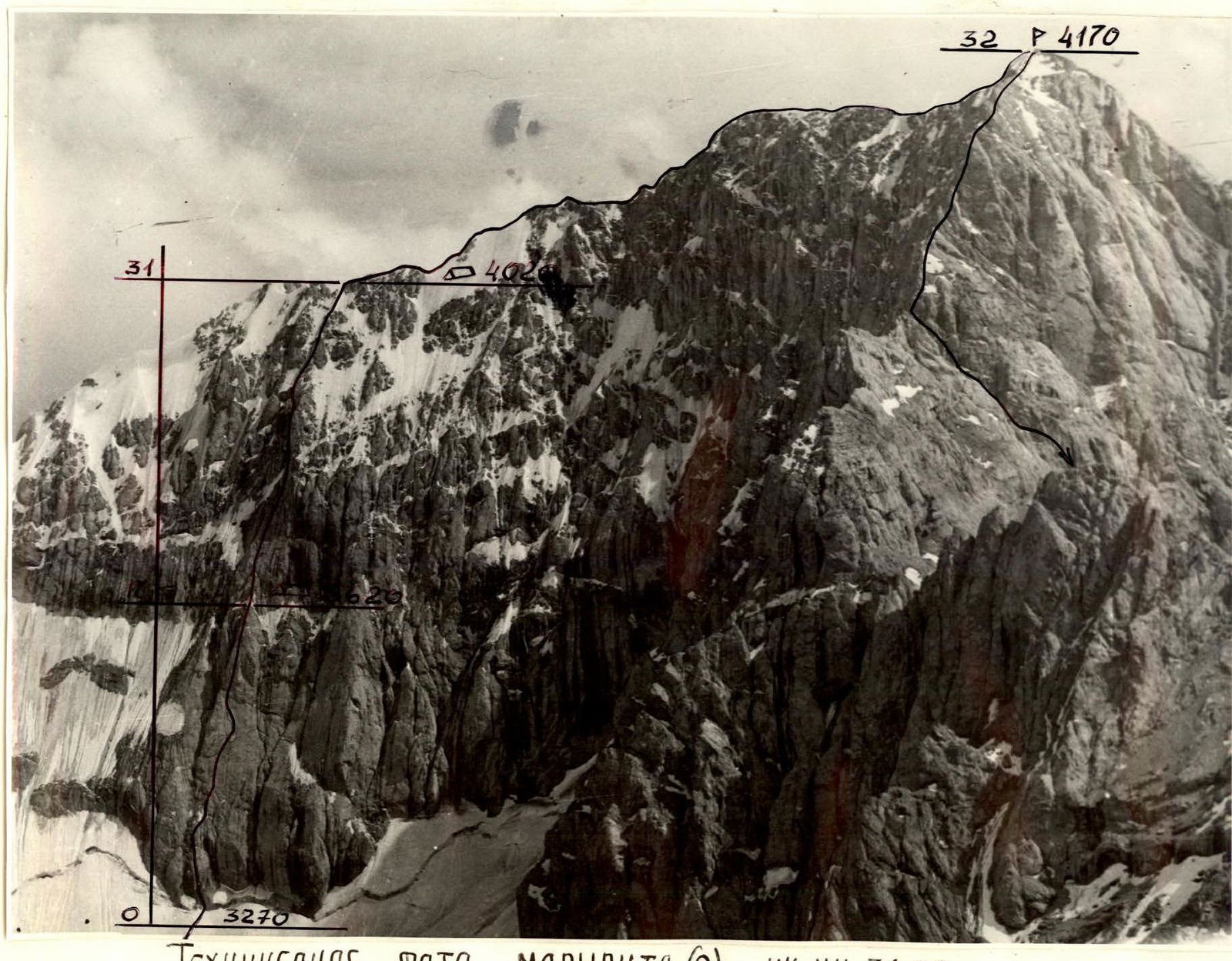
Technical photo of the route (2). Sections R31–R32.
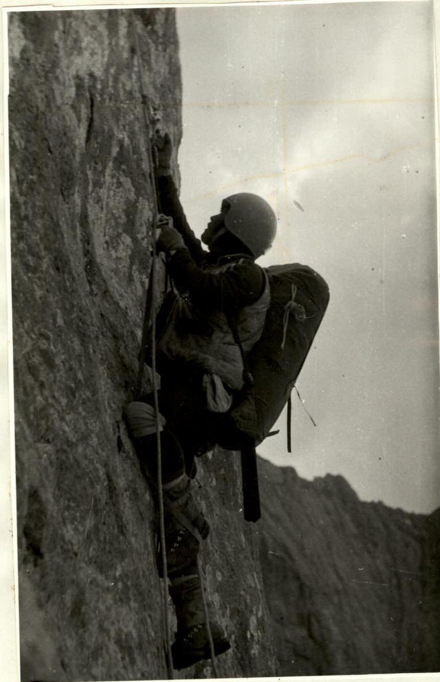
Photo №1. Section R10.

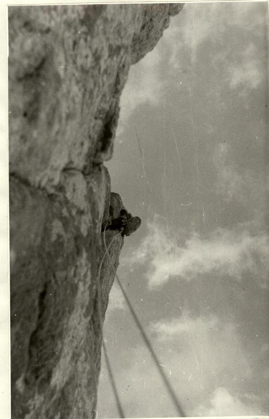
Photo №2. Sections R23–R24.