Passport
-
Climbing category — rock
-
Western Tien Shan, Chatkal Ridge
-
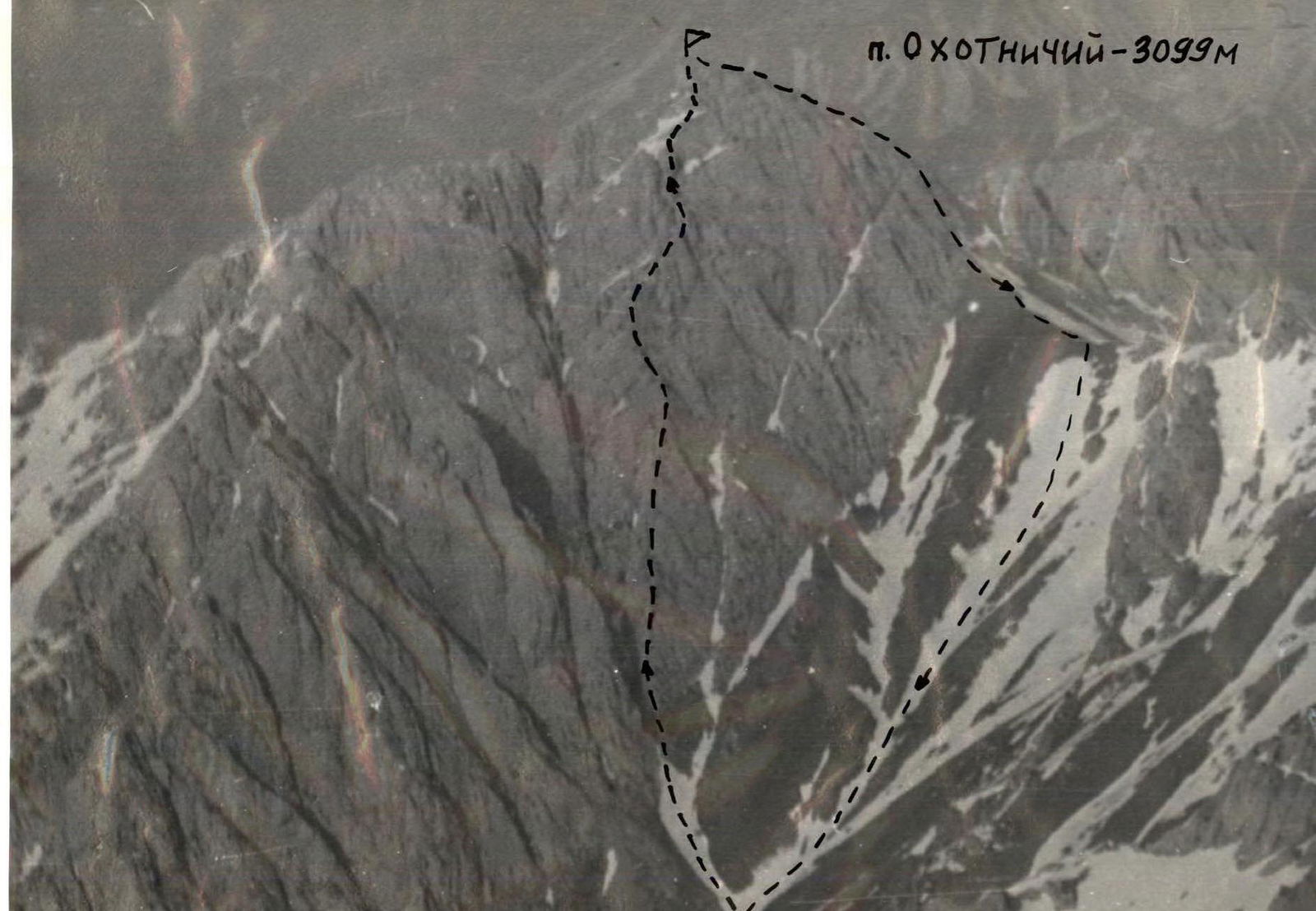
Peak Okhotnichy — 3099 m, via the right counterfort of the Western wall, rock
-
Estimated difficulty category — 3B
-
Height difference — 550 m, length — 1010 m; length of sections with 4th diff. cat. — 95 m;
average steepness of main sections — 50°, of which 4th diff. cat. — 70°
-
Pitons hammered in:
rock 8 bolt – chocks 40 ice –
-
Number of climbing hours — 7
-
Overnights — none
-
Leader: Krakov Boris Grigorievich — Candidate Master of Sports,
Participants: Shanin Anatoly Gennadievich — Candidate Master of Sports, Kravets Andrey Nikolaevich — 2nd sports category
-
Coach — Kotelnikov Anatoly Ivanovich — Master of Sports
-
Departure to the route — May 08, 1991
Return — May 08, 1991
-
Alpinist Club named after V. I. Racek
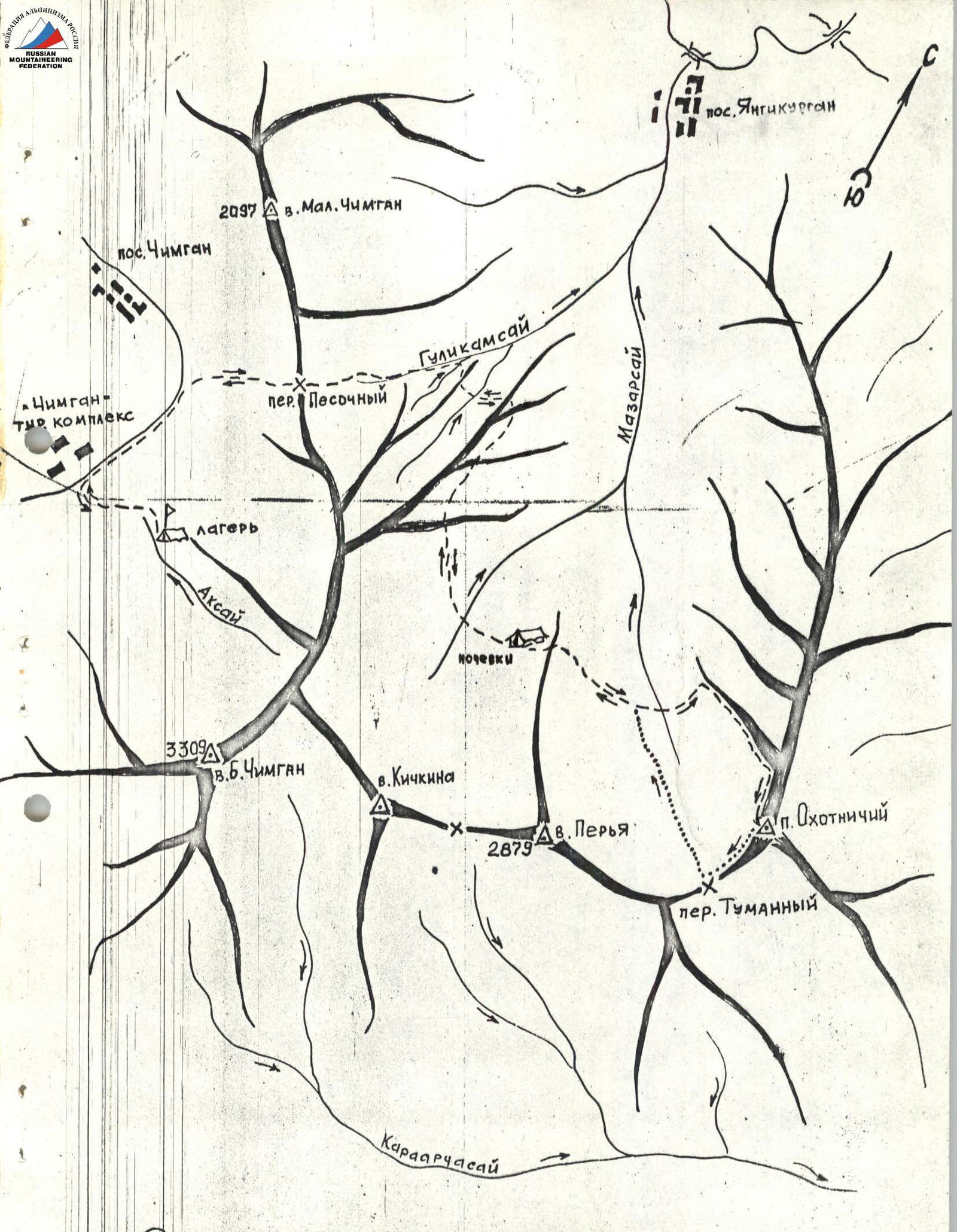
Brief description of the approach
From Yangi-Kurgan settlement upstream along the Mazarsay river to the confluence with the Gulkam river. Then move along the Gulkam river for about 500 m, and then steeply up to the left slope (upper trail). Follow the trail to the upper reaches of the Mazarsay river (6 climbing hours). At the foothills of Peak Peria — bivouac.
From the bivouac to the start of the route, the path goes first along the trail, then crosses a snowfield descending from the Tumanny pass and the counterfort extending from the main ridge; then left-up towards the center of the Western wall. Time — 1 h 30 min. The start of the route is the right side of the couloir separating the Western wall massif.
Peak Okhotnichy

Explanations for the route diagram
| Section # | Brief characteristics | Belaying | Notes |
|---|---|---|---|
| R0–R1 | Snow slope | ice axe | |
| R1–R2 | Monolithic wall leading to an indistinct ridge | chocks, pitons | |
| R2–R3 | Inclined slab | --"-- | |
| R3–R4 | Indistinct ridge with separate slabs | --"-- | 1 belay anchor on a ledge |
| R4–R5 | Inclined ledge to the right of the ridge | via protrusions | |
| R5–R6 | Destroyed wall | --"-- | |
| R6–R7 | Snowfield | ice axe | |
| R7–R8 | Monolithic slab leading to the ridge | chocks | |
| R8–R9 | Snow ridge | ice axe | |
| R9–R10 | Steep destroyed wall | chocks, pitons | |
| R10–R11 | Monolithic wall | --"-- | 2 belay anchors on the left on a ledge |
| R11–R12 | Inclined slabs resting against a pinnacle, bypassed on the right | chocks | |
| R12–R13 | Steep wall | chocks, pitons | |
| R13–R14 | Inclined slabs turning into a ridge leading to the summit | via protrusions |
Descent from the summit to the south, then to the right onto a saddle and to the Tumanny pass, then down the couloir to the upper trail of the Mazarsay river valley.