f. 590 05 4/4–892 35/60

ASCENT PASSPORT TO THE "SOLIDARITY" PEAK VIA S.W. COUNTERFORT OF S RIDGE, CATEGORY 3B DIFFICULTY (tentative).
- TYPE OF ASCENT — rock climbing.
- ASCENT AREA — South-West Tian-Shan, Ugam ridge, Sairam-Su gorge.
- PEAK — Solidarity, 3600 m via S.W. counterfort of S ridge.
- Difficulty category — 3B.
- Height difference — 1045 m, average steepness 45°.
- Pitons used: rock — 12/0, ice — 0/0, bolted — 0/0, utilized chocks — 4/1.
- Climbing time — 12 hours.
- Number of bivouacs — 7.
- Leader — Smertev V.A. (2nd sports category), participants — Belov E.A. (2nd sports category).
- Team coach — Korolsky N.M.
- Departure to the route — May 3, 1988. Return from the route — May 3, 1988.
- THE ASCENT WAS CONDUCTED UNDER THE AUSPICES OF THE Kazakhstan Club of Alpinists in the rock climbing category.
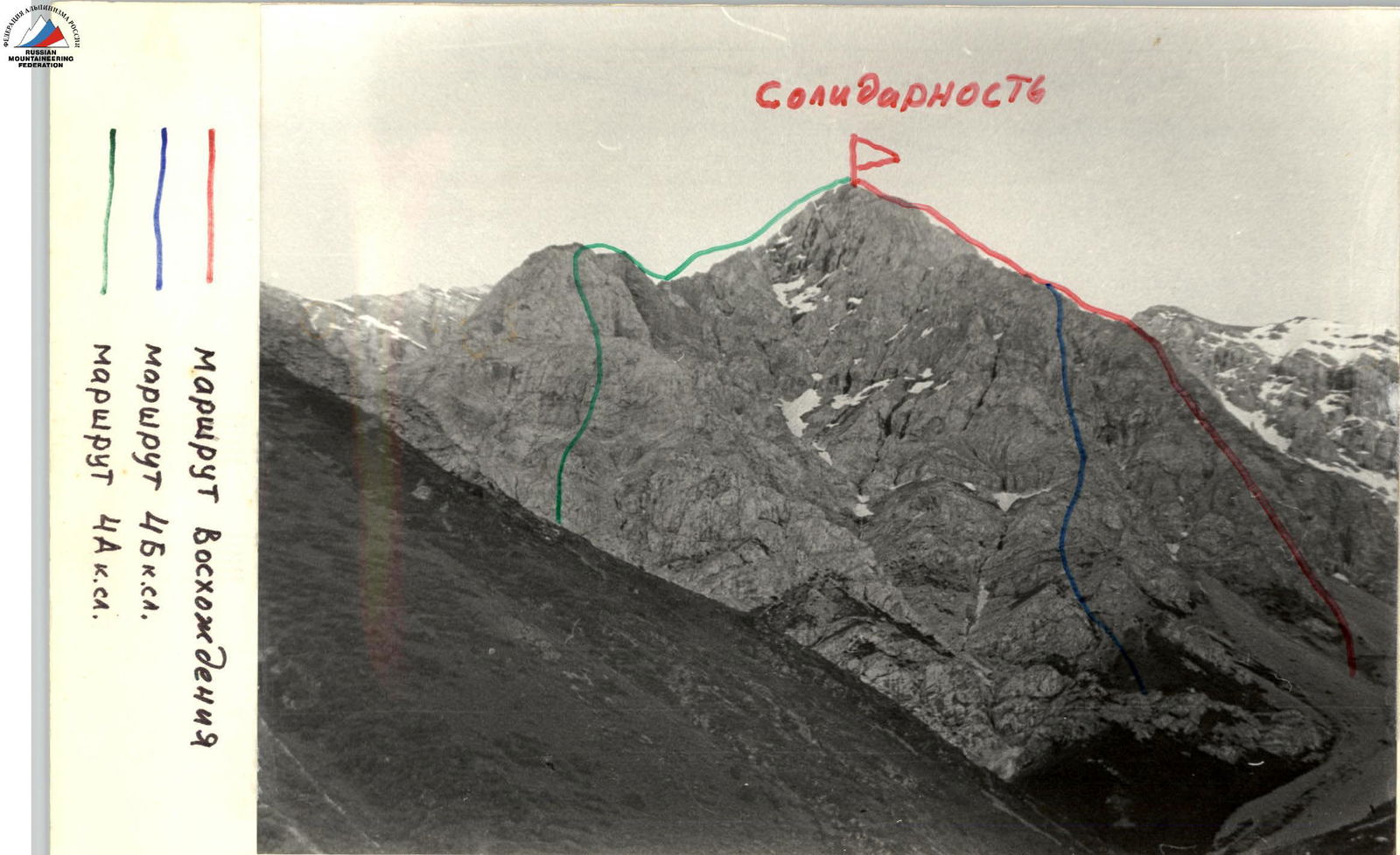
Solidarity
Routes to the Solidarity peak:
- Ascent route
- Category 4B difficulty route
- Category 4A difficulty route
APPROACH FROM THE BASE CAMP TO THE "SOLIDARITY" PEAK TAKES 4 climbing hours via a good trail. The route begins via a pronounced snowy (scree in summer) couloir: after 80 m, we move left to moderately difficult rocks.
- Protection via ledges.
- At the end of the section, there is a shelf convenient for belaying.
- The next 60 m are climbed with piton protection.
- Be careful — many loose rocks.
We reach the wall via a rocky ridge with simple rocks. Belay points are convenient.
- Rocks are complex, thorough belaying is necessary.
- Chocks can be used.
Further along the ridge, we reach a small wall:
- Piton and ledge protection.
Along the ridge and simple rocks (simultaneous movement is possible), we approach the wall:
- One rope length of rather difficult climbing.
- Piton protection.
- Chocks were used to pass the section.
- At the end of the section, there is a convenient belay point (fixed rope can be organized).
Further:
- Another not very steep wall (35–40 m).
- Piton and ledge protection.
- We reach a simple ridge (200 m) leading directly to the summit.
- Simultaneous movement.
Descent from the summit to the south.
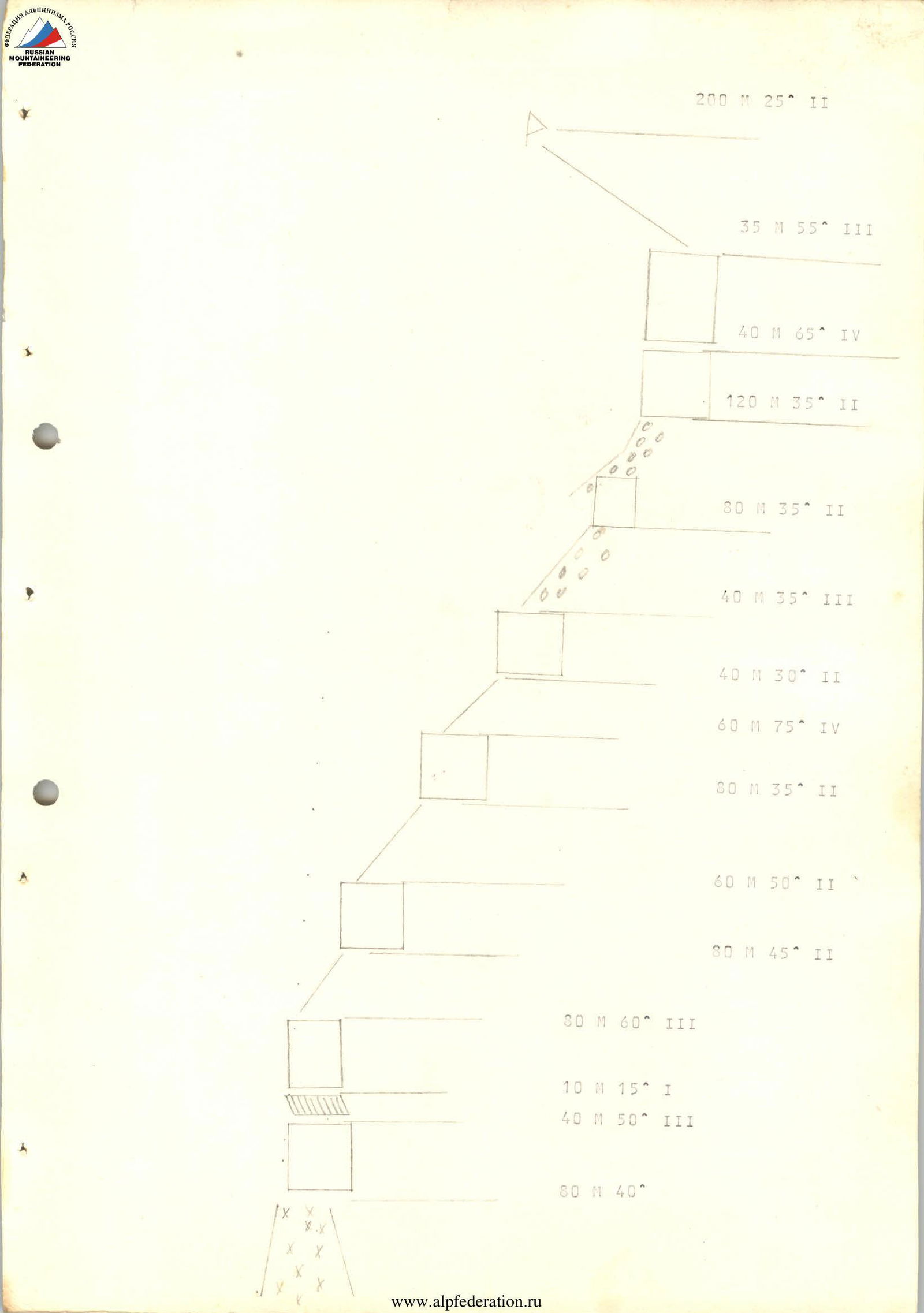
Route elements (diagram):
- 200 m, 25° (II)
- 35 m, 55° (III)
- 40 m, 65° (IV)
- 120 m, 35° (II)
- 80 m, 35° (II)
- 40 m, 35° (III)
- 40 m, 30° (II)
- 60 m, 75° (IV)
- 80 m, 35° (II)
- 60 m, 50° (II)
- 80 m, 45° (II)
- 80 m, 60° (III)
- 10 m, 15° (I)
- 40 m, 50° (III)
- 80 m, 40°
The approach from the base camp to the start of the route takes 3 hours via a good trail along the river to the waterfall. Then, left along the gorge, bypassing "Solidarity," approach the grassy slope and ascend to the col to the I control cairn — this is the start of the route. The first ridge is 40 m with a steepness of 25–30° and is climbed simultaneously. Then, there are two inclined sections of 30 m, 45°. Then, along the couloir along the ridge 100 m and exit to the ridge 30 m, 65°. We find ourselves on a ledge. The rock wall is 40 m, 65° (fixed rope organization); we exit to the ridge. The route continues along the ridge 40 m (simultaneously), we approach the wall — 5 m, 75–80°, and find ourselves under the small tower. The ascent to the small tower is 35 m, 65°; 10 m, 85° is climbed directly (fixed rope), rocks are smooth with tiny ledges. We reach a good ledge (2nd control cairn). Along the large scree ledge, we ascend to the wall of the "Red Tower," the key section. The ascent begins with a 50 m, 85° traverse, complex climbing of the 5th category. We find ourselves at a cleft 40 m, 45°, via which we exit to a good ledge "Red Tower." Then, along the 30 m couloir, we exit to the ridge (simultaneous movement, 3rd control point), under the ridge, we approach the gendarme, which we bypass to the left and exit to the ridge 80 m (alternate belaying). Along the scree slope, we exit to heavily destroyed rocks with a steepness of 50°, rocks are wet, icy. Then, exit to the ridge with a steepness of 70°, 40 m (fixed rope) with an exit to a good ledge. Further, 50 m along the scree ledge, approach to the couloir 30 m, 35–40°. Exit right along the couloir to the pre-summit ridge 40 m, 35–40°, and exit to the "Solidarity" summit. Descent to the south. The entire route takes 10 hours.