Route Description to
to p. Pioneer via the Eastern ridge, approximately category 3A difficulty, completed on August 20, 1987.
Departure from the base camp at 6:00 AM, travel time to the 1st lake is 1.5–2 hours.
From the 1st lake:
- Bypass the northwestern ridge from the right along the scree slope, heading towards a large, wide scree couloir.
- When ascending the scree couloir, stick to its left side, close to the slabs.
- Here is the 1st control point — the beginning of the route.
Further:
- Along the ridge for 40 m, simultaneous movement to the 1st gendarme.
- The gendarme is bypassed on the right via a steep, inclined ledge (400 m).
- Exit onto a destroyed ridge with an average steepness of 45°, length 40 m, which ends with a 35 m wall of 75–80°.
- A chimney runs through the center of the wall.
- Places for hammering in hooks are only in the central part of the wall.
- Climbing is complex.
- At the exit from the wall, there is a convenient spot for organizing insurance, using a rope.
Further:
- Along the ridge, traverse for 100 m to the 3rd gendarme.
- The gendarme is bypassed along a narrow ledge on the right — about 50 m.
Attention! The lead climber moves out of sight behind the gendarme, with hook insurance.
The ledge leads to a 6 m wall with a steepness of 90°.
Further:
- The wall leads to the ridge.
- Then, under the wall, there are 30 m with a steepness of up to 80–90°.
- The wall is bisected by a vertical chimney, partially clogged with plugs.
- Insurance is hook-based; eccentric-shaped chocks work well.
- The person providing insurance may be pulled into the chimney onto accumulated small stones.
- At the exit from the wall, there is a convenient spot for insurance and organizing a rope.
From the top of the gendarme:
- Descend 6 m to a saddle towards the next gendarme.
- The gendarme is climbed directly — a 20 m wall, 70°, climbing of medium difficulty.
- Then, along the scree slope, bypassing the encountered gendarmes on the left, to the summit (350 m).
Descent:
- To the saddle between p. Pioneer and p. Kopatau.
- Along the couloir to the 1st lake.
Ascent Passport
- Ascent class — combined.
- Ascent area, ridge — Western Tien Shan, Ugam ridge.
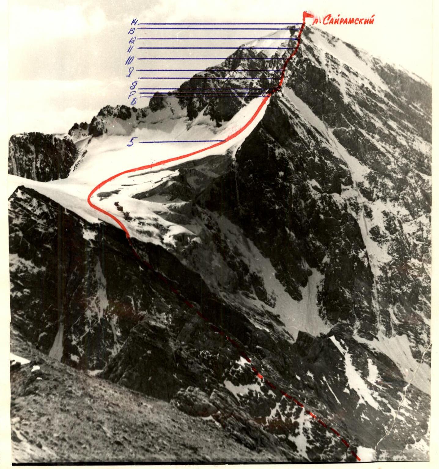
- Peak, its height, ascent route — p. Sayramsky, 4238 m, from Sayramsky glacier along the NE ridge.
- Proposed difficulty category — category 3B (first ascent).
- Route characteristics:
- height difference — 800 m
- length of sections with category 5 and 6 difficulty — none
- average steepness — 50°
- Number of hooks used: rock, ice, chocks for insurance: 11, 10, 7 for creating ITO: none, none, none
- Number of travel hours — 11 hours.
- Number of overnight stays and their characteristics — none.
- Surname, name, patronymic of the leader, participants, and their qualifications. Timofeev Alexander Veniaminovich — Master of Sports of the USSR — leader Podgainy Evgeny Viktorovich — 1st sports category Podgainy Sergey Viktorovich — 1st sports category Akimov Sergey Vladimirovich — 1st sports category Gorn Viktor Fedorovich — 1st sports category
- Team coach — Timofeev A.V.
- Date of departure and return — September 17, 1981.
Brief Description of the Approach to the Route
Peak Sayramsky is the highest point of the Ugam ridge in the Western Tien Shan.
From the base camp, located at the confluence of the Kergeley and Korzhellu rivers (1700 m), the path proceeds as follows:
- Along a good trail along the left bank of the Korzhellu river (see diagram) — 1.5 hours up the gorge to the bridge.
- Cross the bridge and move right — cross a green clearing.
- Then, along the trail, up to the left — onto a terrace lying above the forest boundary.
- Then, along the path to the right — into the gorge of the river flowing from the glacier under p. Sayramsky.
- Up the right side of this small gorge — to the median moraine of the glacier.
- Ascend directly up the moraine along scree and compacted snow — onto the cirque plateau under the northern wall of Sayramsky and the western slopes of p. Enbek.
From the bridge — 2.5 hours.
From here, the ascent path up the snow-ice couloir to the saddle of the hanging glacier is clearly visible.
TABLE OF MAIN CHARACTERISTICS OF THE ASCENT ROUTE
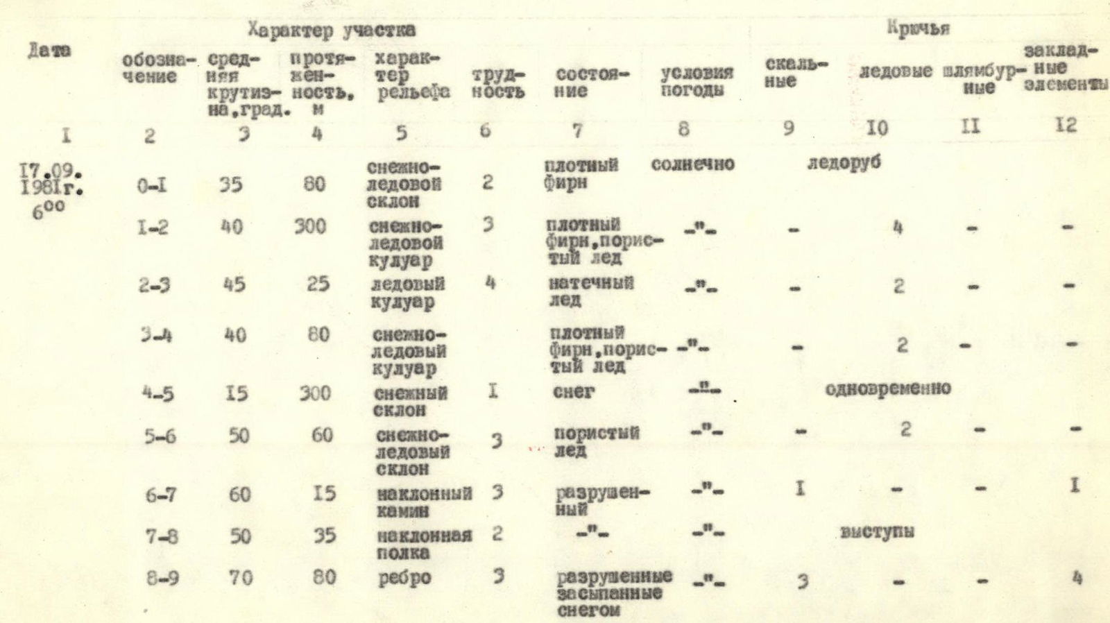
| Designation | Average steepness, degrees | Length, m | Character of relief | Difficulty | Condition | Weather conditions | Rock hooks | Ice hooks | Pitons | Chocks |
|---|---|---|---|---|---|---|---|---|---|---|
| R0–R1 | 35 | 80 | snow-ice slope | 2 | dense firn | sunny | Ice axe | – | – | – |
| R1–R2 | 40 | 300 | snow-ice couloir | 3 | dense firn, porous ice | –"– | – | 4 | – | – |
| R2–R3 | 45 | 25 | ice couloir | 4 | accreted ice | –"– | – | 2 | – | – |
| R3–R4 | 40 | 80 | snow-ice couloir | 2 | dense firn, porous ice | –"– | – | 2 | – | – |
| R4–R5 | 15 | 300 | snow slope | 1 | snow | –"– | simultaneous | – | – | – |
| R5–R6 | 50 | 60 | snow-ice slope | 3 | porous ice | –"– | – | 2 | – | – |
| R6–R7 | 60 | 15 | inclined chimney | 3 | destroyed | –"– | 1 | – | – | 1 |
| R7–R8 | 50 | 35 | inclined ledge | 2 | –"– | –"– | ledges | – | – | – |
| R8–R9 | 70 | 80 | edge | 3 | destroyed, snow-covered | –"– | 3 | – | – | 4 |
| R9–R10 | 75 | 40 | wall | 4 | destroyed | sunny | 4 | – | – | 2 |
| R10–R11 | 40 | 60 | inclined ledge | 2 | – | – | 1 | – | – | – |
| R11–R12 | 20 | 50 | sharp ridge | 2 | – | – | ledges | – | – | – |
| R12–R13 | 50 | 100 | ridge | 3 | destroyed | –"– | 2 | – | – | – |
| R13–R14 | 20 | 200 | scree ridge | 1 | scree | –"– | simultaneous | – | – | – |
Departure time on the route: 6:00 AM. Summit: 5:00 PM. Travel hours: 11.
Brief Explanation of the Table
R0–R1. Ascend the snow-ice slope to the beginning of the couloir, located at the rock "tie" and icefall. Movement in crampons is simultaneous, slope steepness is 35°.
R1–R4. Through the snow-ice couloir, exit onto the saddle of the hanging glacier, movement in the couloir is alternating with hook insurance. In the central part of the couloir, there is accreted ice; the average steepness of the couloir is 40°.
R4–R6. Along the snow-ice slope, ascend to the beginning of the northeastern ridge, moving towards the first couloir on the right. Movement is simultaneous; the average slope steepness is 30°.
R6–R7. From the couloir, via a chimney, exit onto an inclined slab; insurance is hook-based, steepness is 60°.
R7–R9. Moving up the inclined ledge, exit onto the ridge, which abuts a wall. Movement is simultaneous; insurance is through ledges. Under the wall, there is a control point.
R9–R10. The wall is climbed directly with alternating hook insurance. Steepness is 75°.
R10–R14. Further along the ridge, exit onto the summit. Movement is simultaneous; insurance is through ledges; the average steepness is 35°. Descent is via category 2A route.