REPORT
on the ascent to peak Arsen in the western part of the northern wall (first ascent), category 5B difficulty, of the Sports Committee team of the Kazakh SSR
Team members:
- 30/11-77
- Denisenko A.A.
- Vorobyov A.S.
Western Tian-Shan, Ugam ridge 1977 www.alpfederation.ru↗
Approach to the route
From the village of Kaska-Su by car road (23 km) to the base camp located at the confluence of the Kergely and Bezymyannaya rivers. From the base camp, move along the Bezymyannaya River on the right bank for 15–20 minutes, then cross to the left bank. Further movement in the direction of the river flow until it disappears in the moraine takes 1.5–2 hours, and then continue in the southern direction. To the left is a gorge leading to the peak Sayram. From the south, after 1.5–2 hours, we reach the route. To the right of the route, a pronounced counterfort is visible. The descent from the summit is made in the reverse direction to the 4th control cairn and further, after descending from the snowy shoulder, we leave the ridge via a couloir to the southwest.
If the descent from the summit ridge begins before descending from the snowy shoulder, one has to descend along a very steep glacier turning into an icefall.
In its lower part, the couloir widens and enters a narrow canyon, along which we descend to the Kargaly River on a trail leading to the base camp.
The descent time from the summit to the base camp is about 4 hours.
The name of the peak Arsen is adopted by us according to the stories of local residents. There is a legend associated with the name Arsen, but not knowing the local language did not allow us to find out why this peak is named so.
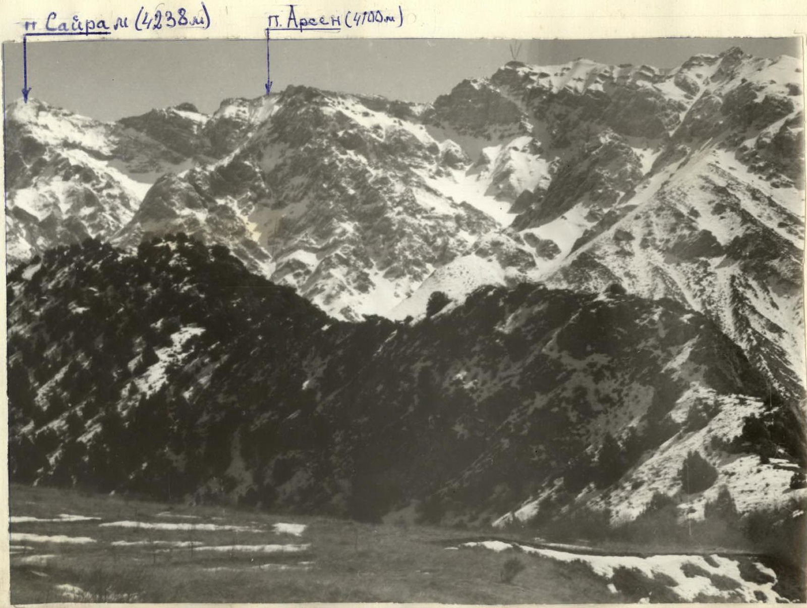
Panorama of the area
Route characteristics table

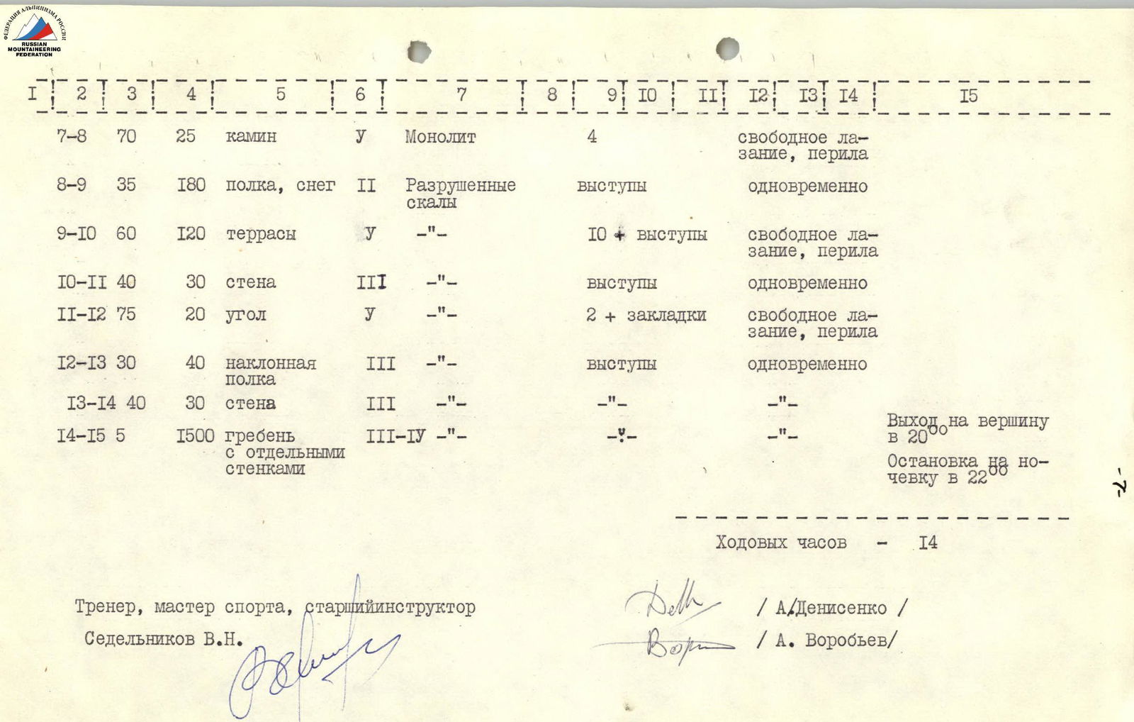
Coach, Master of Sports, senior instructor Sedelnikov V. N.
4. Explanation for the route characteristics table
4.1. General characteristics of the route.
The route is a weakly expressed counterfort located in the western part of the northern wall of peak Arsen. The route leads to the ridge. After 2 hours 30 minutes of movement along the ridge in the eastern direction, we reach the summit. The route is purely rock, composed of crumbling rocks, and is objectively safe.
Possible risks:
- Rockfall when passing the first three ropes.
- The fall occurs along the couloir, which is located to the right of the route after 900.
The route was climbed using free climbing. Climbers moved along the route in gym shoes. The route is logical. On the right, in the lower part, it is limited by sheer cliffs. In the upper part, it is bounded by a rockfall-prone couloir; on the left, there is a powerful waterfall.
After passing 2/3 of the wall, there is a large shelf where it is possible to organize an overnight stay.
On the route, the following were installed:
- 4 control cairns.
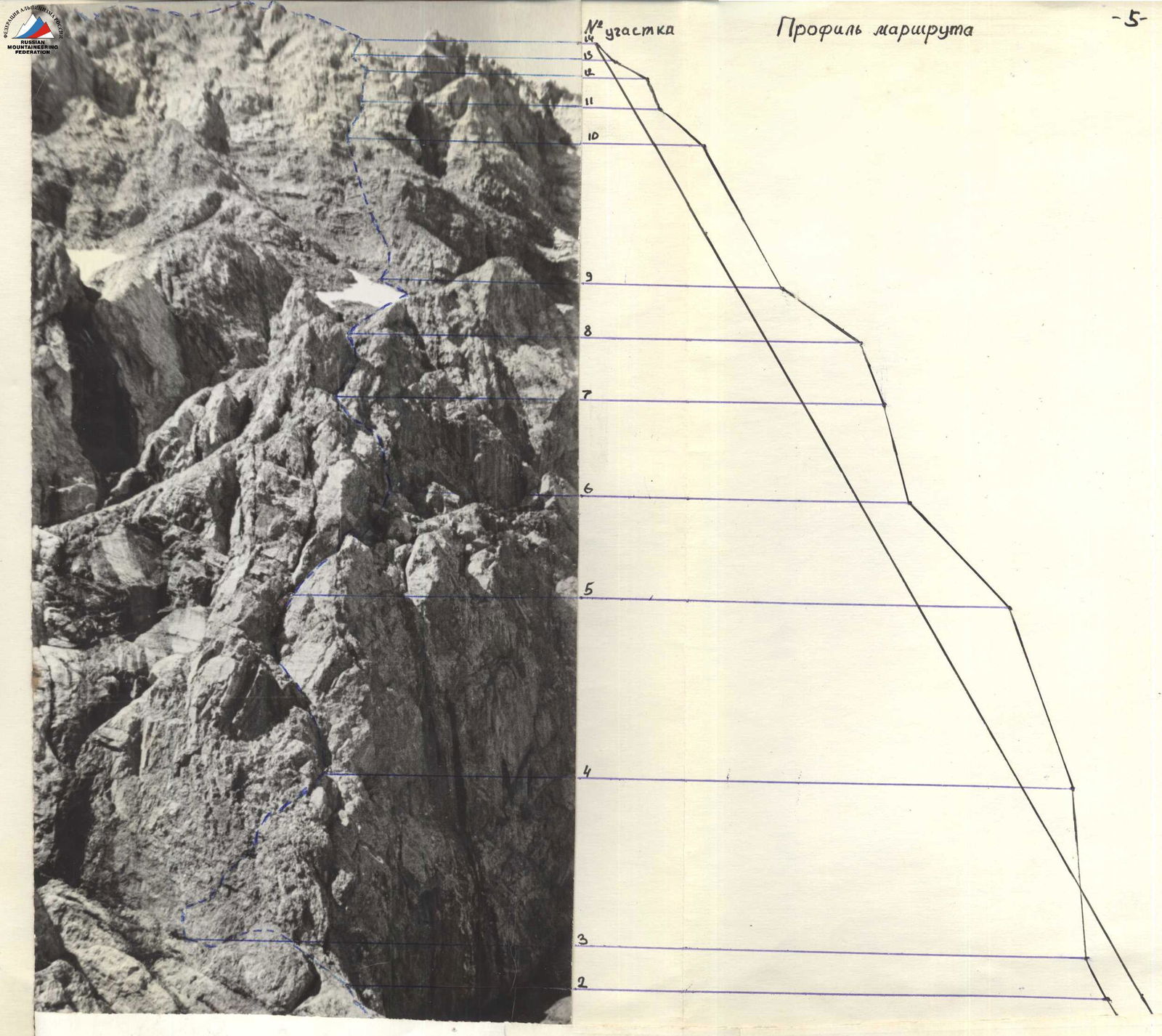
4.2. Route description.
The beginning of the route is along a steep firn slope (section R0–R1) to a clearly visible lower part of the counterfort, but then an ascent is made on its right side onto a shelf (section R1–R2) and along the shelf 25 m to the left upwards (section R2–R3). Here is the 1st control cairn.
In the area R0–R3, rockfall is possible from the couloir, which is located to the right of the route.
Then it is necessary to overcome a 35 m wall. Climbing is difficult, with small, fragile holds. In the right part of the top of the wall, there is a large rock ledge, behind which it is convenient to organize protection. Then we reach a corner that leads to a chimney. After 35 m, the chimney splits into two, and the right part turns into a corner, along which we reach a jumble of blocks on a shelf.
Further:
- Along the shelf to the right
- Then to the left upwards
Along a wall with large ledges, we reach another shelf. Here is the 2nd control cairn. Further along the chimney, we reach a huge shelf with a large snow patch. Along the shelf, we approach the wall and then to the left upwards along inclined terraces, we reach the main ridge. Here is the 3rd control cairn.
The terraces are very crumbling, so movement requires great caution.
Further along the ridge in a northwesterly direction — the ridge is very gentle. After a characteristic ascent before the snowy plateau, the 4th control cairn is installed.
After 1 hour, we reach the summit. The total time spent moving along the ridge was 2 hours 30 minutes. No signs of human presence were found on the summit. The most diverse pitons were used on the route:
- petal-shaped — in the lower part;
- wedges — in the upper part of the route.