Ascent Passport
-
Ascent type — rock climbing
-
Ascent area — Western Tian-Shan, Ugam Range
-
Peak, its height, ascent route — I-st tower of Peak Arsen, 3800 m; via the northern counterfort
-
Estimated difficulty category — 3B
-
Route characteristics:
height difference – 490 m, route length – 700 m, 2nd diff. cat. – 430 m, 3rd diff. cat. – 160 m, 4th diff. cat. – 85 m, 5th diff. cat. – 35 m. Average steepness – 45°
-
Number of pitons: for belaying, for creating KTO:
- rock pitons 36
- ice screws
- bolt pitons
-
Number of climbing hours — 14 hours
-
Number of nights and their characteristics — the route is one-day
-
Surname, name, patronymic of the leader and participants and their sports qualification:
Skrekhin Mikhail Nikolaevich, 2nd sports category, leader Shapovalov Valery Nikolaevich, 2nd sports category, participant Ashkenov Kopan Kopanovich, 2nd sports category, participant Frolov Pavel Evgenievich, 2nd sports category, participant
-
Team coach: Master of Sports, Honored Coach of KazSSR IL'INSKII E.T.
-
Date of team departure to the route June 30, 1977 Date of return June 30, 1977
Geographical Overview
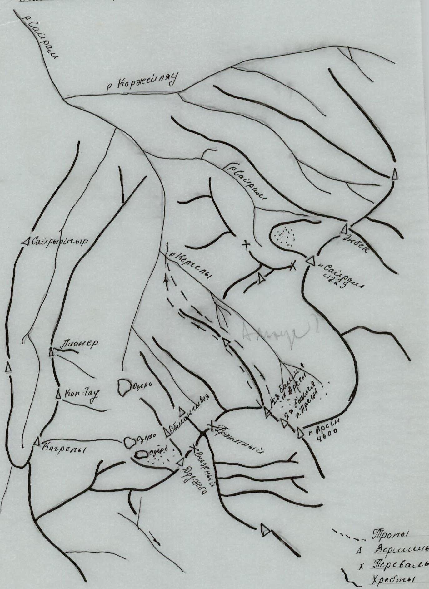
The I-st tower of Peak Arsen (3800 m) is located in the Ugam Range in the upper reaches of the Kergely River, a left tributary of the Sayram River. The Ugam Range is a spur of the Talasskiy Alatau, part of the Western Tian-Shan mountain system. This part of the Ugam Range is characterized by:
- sedimentary deposits, which cause the rock to be unstable and relatively prone to rockfall.
The glaciation of the area is insignificant, with small cirque glaciers being typical. The accumulation zone of the glaciers is generally small; they are nourished by winter snow cover.
The climate in the area is sharply continental with many sunny days. The most favorable time for mountaineering activities is from May to October. The area is easily accessible, with the nearest major city being Chimkent.
Approach to the Route
From the city of Chimkent, take the highway to the settlement of Kasha-Su. Continue along the left (orographically) side of the Sayram River to the confluence of the Sayram and Kergely rivers (23 km). Here is a clearing — a convenient place for a base camp.
During the rainy season, the road becomes heavily eroded, making access difficult.
From the base camp, follow the trail upstream along the Kergely River to its source, staying on the left (orographically) side. Peak Altus remains on the right. When approaching the glacier (the glacier has no name), a clearly visible triangle will be seen in the northern direction. In the lower left part of the triangle is a large snow shelf leading to a rock. On the rock shelf is the 1st control cairn. This is the start of the route.
| Date | Designation | Average steepness in degrees | Length | Difficulty | Terrain characteristics | Condition | Weather conditions | Rock pitons | Ice screws | Bolt pitons |
|---|---|---|---|---|---|---|---|---|---|---|
| 30.06.77 | R1 | 35 | 80 | 2 | Snow-ice | Snow-ice | good | - | - | - |
| R2 | 40 | 40 | 2 | Wall | Unstable | "" | - | - | - | |
| R3 | 45 | 40 | 2 | Shelf | Unstable | "" | 3 | - | - | |
| R4 | 60 | 40 | 3 | Wall | Steep, solid rock | "" | 5 | - | - | |
| R5 | 60 | 25 | 4 | Wall | Monolith | "" | 5 | - | - | |
| R6 | 50 | 30 | 3 | Ridge | Unstable rock | "" | 1 | - | - | |
| R7 | 30 | 80 | 2 | Ridge | Unstable | "" | - | - | - | |
| R8 | 60 | 25 | 4 | Wall | Monolith | "" | 5 | - | - | |
| R9 | 30 | 70 | 2 | Ridge | Unstable | "" | - | - | - | |
| R10 | 60 | 60 | 3 | Wall | Solid rock | "" | 2 | - | - | |
| R11 | 65 | 35 | 5 | Wall | Monolith | Rain | 6 | - | - | |
| R12 | 65 | 35 | 4 | Wall | Monolith | Snow | 6 | - | - | |
| R13 | 65 | 30 | 3 | Wall | Unstable rock | Snow | 3 | - | - | |
| R14 | 30 | 120 | 2 | Ridge | Unstable | Snow | - | - | - |
Explanation of the Table
Route Characteristics
The start of the route is a small, clearly visible triangle. The approach to it is via a 35° snow-ice slope, 80 m long, with ice axe belay. The firn is not too hard, and steps are well-defined — section R1.
Section R2. A moderately steep, 40° wall, unstable, with belay on protrusions. Length 40 m. Exit to a small triangle. The first control cairn is on the small triangle.
Section R3. It is an oblique shelf, 45°, 40 m long. At the beginning of the shelf, there is a 3 m overhanging cornice, and three pitons are hammered here.
Section R4. Begins with a 70° wall, 15 m, with piton belay, five pitons hammered. Then a less steep wall, 65°, with good holds and belay on protrusions, followed by an exit to a shelf, which is quite large, 5 m, convenient for receiving the next participant.
Section R5. The first crucial section. A 80° wall. 5 m of difficult climbing, three pitons hammered. Then a chimney, 20 m, 60° steep, two pitons hammered, and an exit to a 4–5 m shelf. Belay on protrusions.
Section R6. Represents a rocky, destroyed ridge, 30 m long, 50° steep, with combined belay, one piton hammered.
Section R7. A gentle ridge, 30°, quite wide, 80 m long. Simultaneous movement. Control cairn.
Section R8. A 55° wall, 20 m long, unstable, with piton belay, then the wall becomes steeper (up to 80°), with five pitons hammered during the passage.
Section R9. Exit to a ridge, 70 m at an average steepness of 30°, with alternating belay.
Section R10. Represents a 60° wall with good holds, moderate climbing, 60 m, with combined belay, two pitons hammered upon exiting to a shelf.
Section R11. The second crucial section, which begins with a traverse of the shelf to the right, followed by a sheer wall, 90°, 12 m, with a crack in the wall that facilitated passage, six pitons hammered. Above, the wall becomes less steep (up to 70°), 15 m long, with six pitons hammered and rappel ropes hung. Rain started.
Section R12. A 70° wall, 30 m long, with piton belay, six pitons hammered, rain turned to snow, visibility good, not cold. Then an exit to a small ridge, 20 m, ending in a gendarme.
The gendarme is climbed directly, a 30 m wall, 65° steep, with unstable rock: piton belay and on protrusions, three pitons hammered, snow falling.
Section R14. Pre-summit ridge, 120 m, with alternating belay.
We reach the summit, build a cairn. Descent is via Peak Altus on route 1B difficulty category to a large clearing in the base camp. Total route time — 14 hours.