ALTUS ZAPADNYI 3090 m via western ridge, cat. dif. ASANOV B.Zh., 2009
prom_alp3@mail.ru 7.11 — Tian-Shan, Ugam ridge
Report
on ascending the western ridge of mt. ALTUS (7.11 — Western Tian-Shan, Ugam ridge), made by the group of alpinada "SAIRAM — 2009" (opened by Mountaineering Federation of South Kazakhstan region)
Annex 1: ASCENT FILE
-
Ugam ridge, Sairam-Su river valley (7.11)
-
Altus Zapadnyi 3090 m via western ridge X)
-
Proposed cat. dif.: 2A
-
Character: rock.
-
Height difference according to group’s altimeter: 1290 m, including ridge part height difference: 840 m. Total route length: about 3000 m, out of which II and II+ cat. dif.: 190 m, III–III+ cat. dif.: 120 m. Average ridge steepness: 25°, technical sections steepness: from 40° to 60°.
-
Left on route: no pitons or stoppers, 2 old pitons removed.
-
Time on route – 8 hours, days – 1.
Route start at 6:00 on May 8, 2009 (exit from base 1760 m at 5:00), summit reached at 14:00 on May 8, 2009.
-
Descent from summit to Sairam-Su valley – 3 hours via northern ridge, cat. dif. 1B; return to base at 17:00 on May 8, 2009.
-
Leader: ASANOV Bakhyt Zholdasbekovich – 1st sports category, Shymkent
Participants:
- AMIRBEKOV Zhomart Amirseituly – "Alpinist of Kazakhstan" badge holder
- STARTSEV Vladimir Vitalyevich – "Alpinist of Russia" badge holder
- TOYSHIBEKOV Tugyrkhan Nakhanbekovich – "Alpinist of Kazakhstan" badge holder
- USAEVA Venera Israfilovna – "Alpinist of Russia" badge holder
-
Coach: LEVIN Mikhail Semenovich, Master of Sports of USSR, 1st category coach (Chelyabinsk). Senior coach of alpinada "Sairam — 2009": TIMOFEEV Alexander Veniaminovich, Honored Coach of Kazakh SSR, Master of Sports of USSR, 1st category coach (Almaty).
-
Organization: Mountaineering Federation of Perm and "Ural Rock Climbers" Non-Profit Educational Organization
-
Person responsible for the report х): Levin M.S. Lms_ms@mail.ru
х) M.S. Levin already led groups from Mountaineering Federation of Bashkortostan on this route back in 1998–2000, 2001, however they did not take full photo documentation. Nevertheless, a report was sent to FAR in 2000.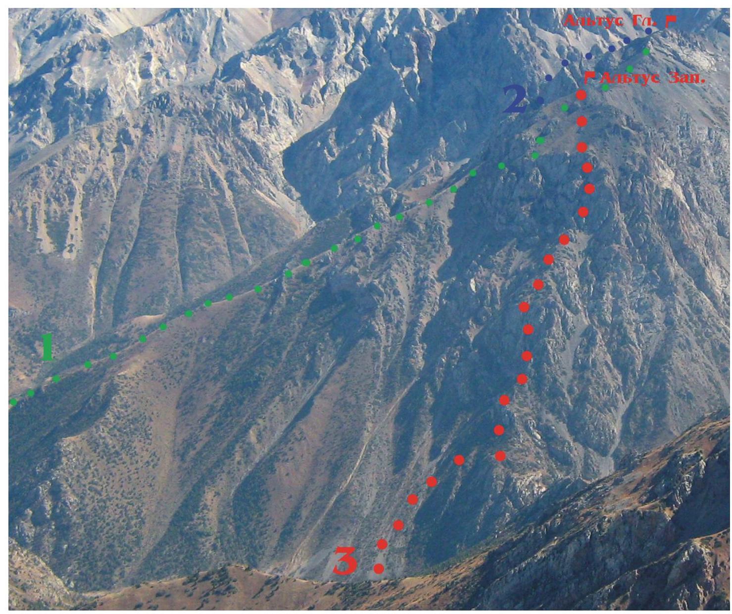
Photo #1: taken on September 25, 2007 from the ridge of mt. Sary-Aigyr (B. Asanov).
- V. Shataev 1974, Altus Zap.–Gl., N. ridge traverse, cat. dif. 1B
- A. Yusev 1998, Altus Gl. N. ridge, cat. dif. 2B
- this report: B. Asanov 2009, Altus Zap., W. ridge (cat. dif. 2A)
WE REQUEST Classification Commission to make the following changes to CMGVR, specifically: to split the routes into:
- Altus Zap.
- Altus Gl., each having a northern ridge:
WAS BECAME
| 1. (this report) | Altus Zap. | 3090 | (2A) | rock | W. ridge | B.Asanov, 2009 |
|---|---|---|---|---|---|---|
| 2. Altus N. ridge | Altus Zap.–Gl. | - | 1B | rock | N. ridge, traverse | V.Shatayev, 1974 |
| 3. Altus left N. ridge | Altus Gl. | 3200 | 2B | rock | N. ridge | A.Yusev, 1998 |
| 4. Altus from N via E. ridge | Altus Gl. | 3200 | 2B | comb | from N via E. ridge | M.Levin, 1999 |
| 5. Altus E. rib of N. ridge | Altus Zap. | 3090 | 3B | rock | E. rib of N. ridge | Sh.Rafikov, 1977 |
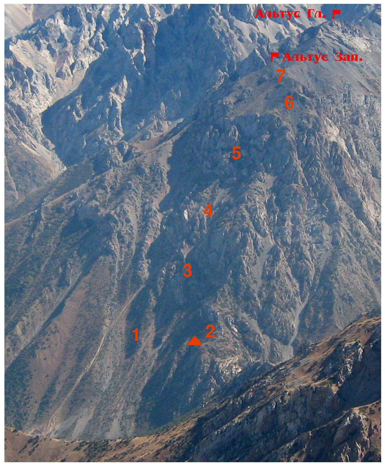
On lower photo #3 Kergely valley is seen. On upper photo #2 mentioned northern ridges are seen. Routes on Altus Glavnyi and on Altus Zapadnyi are shown:
- this report: B. Asanov 2009, Altus Zap., W. ridge (cat. dif. 2A)
- V. Shataev 1974, Altus Zap.–Gl., N. ridge traverse, cat. dif. 1B
- A. Yusev 1998, Altus Gl. N. ridge, cat. dif. 2B
- Sh. Rafikov 1977, Altus Zap. E. rib of N. ridge, cat. dif. 3B
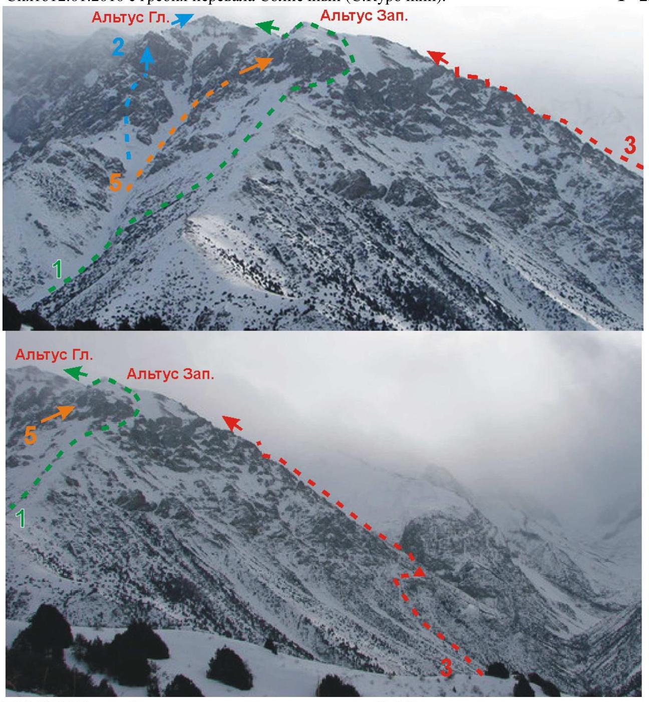
Upper photo #4 taken on May 7, 2009 from slopes of Solnechnyi pass (Zoya Korneenkova): ROUTE PROFILE from north.
Lower photo #5 taken in August 2000 from 2320 m lake (K. Mokhov): ROUTE PROFILE from south.
Panoramas:
Upper photo #6 taken on September 25, 2007 from the ridge of mt. Sary-Aigyr (B. Asanov). In the background — peaks of Ugam ridge on the border with Uzbekistan. Shown (left to right):
- Enbek 3850 m
- Sairam 4238 m
- Solidarnosti 3500 m
- Chimkent 3980 m
- Arsen, BARS-2 and Ayutor (ascended during Sairam–Ayutor traverse; no separate routes on them yet)
- BARS-1 3800 m
- Altus Gl. 3200 m
- Altus Zap. 3090 m (route described here via W. ridge)
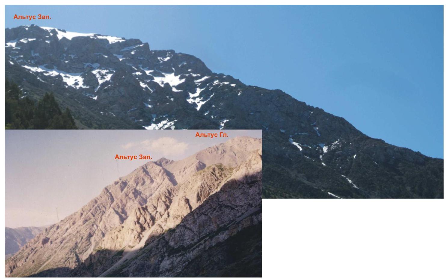
Lower photo #7 taken in July 1998 from point "6" (A. Yusev). Shown (left to right):
- BARS-2 3980 m (ascended during Sairam–Ayutor traverse)
- BARS-1 3800 m
- Sofia 3100 m
- Altus Gl. 3200 m
- Altus Zap. 3090 m (route described here via W. ridge)
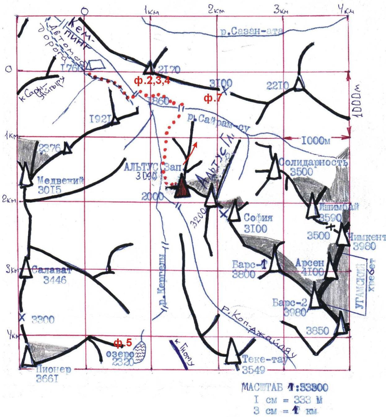
Camera positions of report photos are shown: pic. 2, 3, 4, etc.
Ascents in Sairam-Su and Kergely river valleys from Chimkent officially started in 1962. Many routes were pioneered in 1974 by a group from USSR Sports Committee led by V.N. Shataev – including on mt. ALTUS (named after Chimkent club that united:
- ALPINISM,
- TOURISM,
- SPELEOLOGY).
After a motor road was built in 1993 (70 km from Shymkent) this became a recreation area, now a national park (in 2009 – about 75 RUB/person/day).
Altus massif is one of the nearest peaks (see photo #8 on pg. 5–9), to which
- schoolchildren are taken,
- record-breaking runs are organized.
BRIEF ROUTE DESCRIPTION
The journey from Chimkent to the checkpoint at the entrance to "Sairam" national park takes less than 2 hours, and another 6 km to the second checkpoint before the camping site.
If it's closed for entry, it takes about 1 hour to walk along the road through the camping site to the 1760 m meadow. Western ridge of Altus (route described here) is not fully visible from the meadow; one needs to follow the road further, which ends at a ford, then reach a rock press, cross to the right (orogr.) bank of Sairam-Su via a bridge, soon cross back to the left bank via another bridge and follow south along Kergely river.
Upon exiting the Kergely valley forest the whole western ridge comes into view; approaching its slope, turn left–upwards along a wide "white" couloir (turning point marked at 1800 m, no more than 60 min approach).
Up along the middle scree, aiming for a wide flat saddle 2250 m on the western ridge. Having ascended directly to about 2170 m, turn right–upwards towards the saddle (2–2.5 hours from 1760 m base). Here is the landmark cairn 2250 m with a "stick", serving as a reference point for groups approaching from the south, from 2320 m lake.
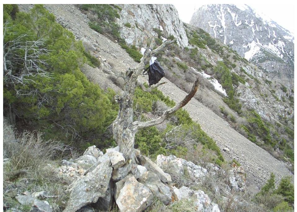
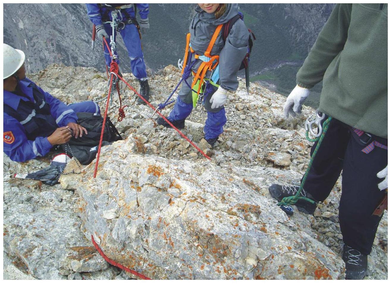
Photo "a" From here – in rope teams. Do not cross over to the adjacent ridge on the right! From the cairn – along the left ridge line, quite eroded; detours possible. Seeing ahead (3–4 hours from the saddle) the key ascent (III–III+, 120 m), it is recommended to have a snack (carry water!)
After "troika" rocks about 1 hour to the summit (3090 m). Descent via northern ridge, cat. dif. 1B.
Recommendations:
- Do not go straight up everywhere
- Consider detours in advance
- The key ascent cannot be bypassed ("not worth it")!
TECHNICAL PHOTO #8
taken on September 25, 2007 from the ridge of mt. Sary-Aigyr (B. Asanov).
Notes from:
- landmark cairn 2250 m (R. Khairullin, August 2001)
- summit of Altus Zapadnyi (group of E. Urazalin, May 6, 2009)
were handed over to the training section of Alpinada of South Kazakhstan Federation of Alpinism and Sports.
TABLE OF MAIN CHARACTERISTICS in UIAA symbols
(scale 1:5000 vertically)
SUMMIT 3090 m, 14:00
| №№ sections | Length in m; (heights) | Steep. in deg. | Character of terrain | Cat. dif. | Belay (number of "piton") | UIAA Symb. | NOTES; Time of movement start |
|---|---|---|---|---|---|---|---|
| 8 VIII 7 | opt. 200 m (3000 m) | 25–30° | To flat top — not deep snow (in summer — scree) | 1 | Simultaneous walking without belay | 13:40 | |
| 7 | Scree of wide ridge | 1 | Simultaneous walking without belay | (photo "b") 13:15 | |||
| VII 6 | opt. 800 m (2740 m) | up to 20° | Steep rock ascent 11:40 | ||||
| 6 I 5 | opt. 130 m (2600 m) | from 35 to 60° | Solid limestone | up to III+ | 12 stoppers and ledges with loops; rope protection | Long snack, then along wide ridge to the saddle under the key pulls under the key rock ascent 10:35 | |
| 4 | opt. 800 m (2380 m) | 10–15° | Scree with grass | 1 | Simultaneous walking without belay | Long snack, then along wide ridge to the saddle under the key rock ascent 10:35 | |
| 4 1 III 3 | opt. 190 m (2260 m) | 40–45° | Solid limestone | II; II+ | 5 stoppers and ledges with loops; rope protection | Several rock ascents 08:00 | |
| III | opt. 100 m (2260 m) | 5–10° | X) (photo "a") | 1 | Rope team org. | 2250 m Landmark cairn 07:30 | |
| II 1 | opt. 130 m (2170 m) | up to 40° | Detour around rock outcrops via scree and grassy ledges | 1 | Simultaneous walking without belay | Diagonal ascent right–upwards to W. ridge saddle to landmark cairn 7:00 | |
| 1 | opt. 650 m (1800 m) | 35° | Medium and small scree of "white" couloir | 1 | Simultaneous walking without belay | At the junction of W. slope of N. ridge with N. slope of W. ridge — wide "white" couloir 6:00 |
X) on horizontal grassy saddle with a "stick" — landmark cairn; from here — in rope teams!
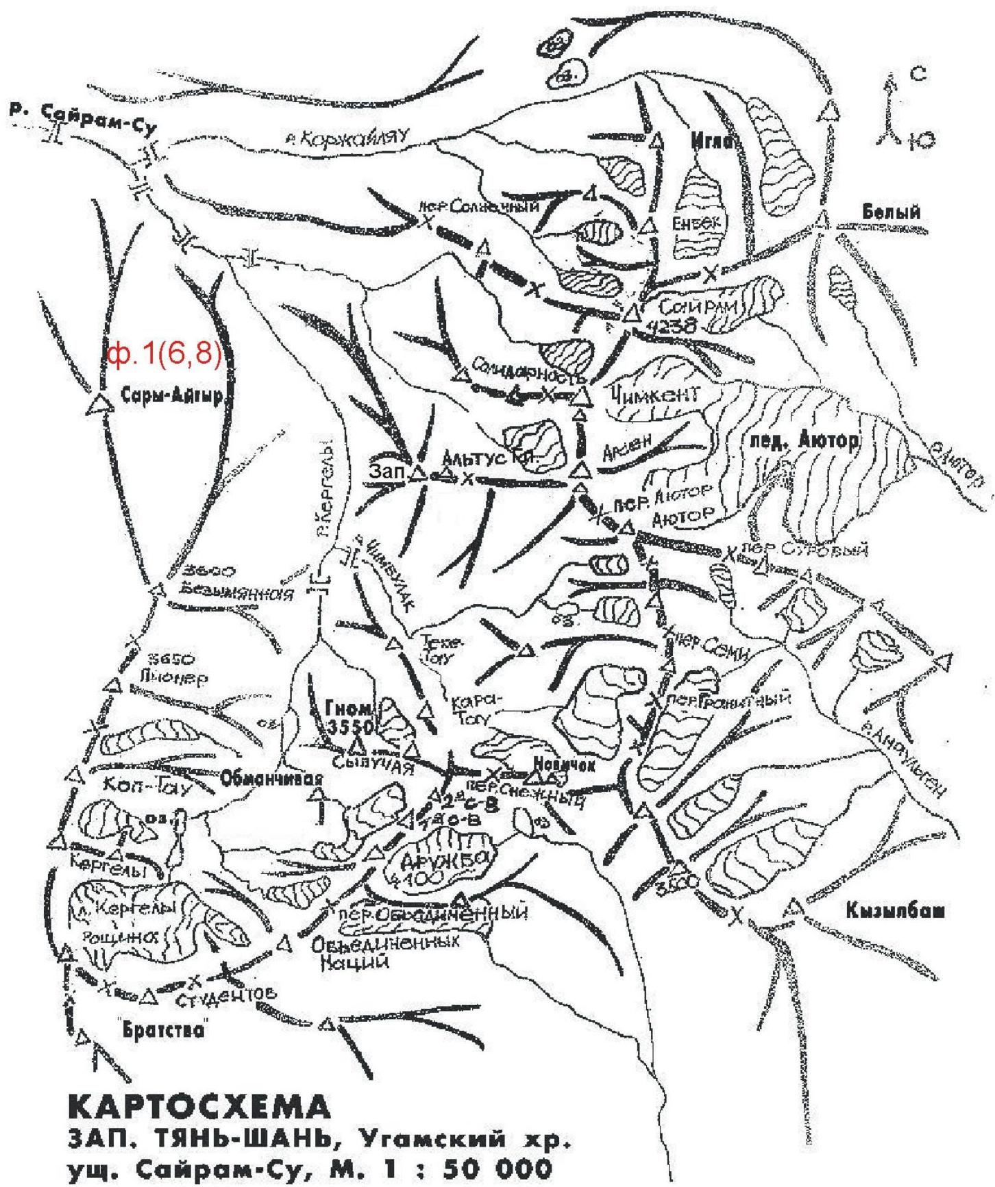
MAP DIAGRAM W. TIAN-SHAN, Ugam ridge, Sairam-Su valley, scale 1:50000
NOTE: This tourist map diagram appeared before 1995; seemingly, it's Kazakh: instead of A. Snesarev peak — peak Bratstva.
Photo #9: taken from a car on May 8, 2006 between camping site and 1760 m base (B. Asanov).
GENERAL VIEW OF THE PEAK on the way to the valley (ALAS, the start of the route is out of frame)
Left to right:
- highest peak of Sairam area, 4238 m;
- Ssolidarnosti peak massif (summit is clouded);
- ARSEN peak with a "triangle" on its shoulder;
- ALTUS massif.
Photo "b": end of section R5–R6, then simultaneous walking. Alas, no photo was taken at the summit – we were in a hurry.