
Ascent Log
- Ascent Category: Technical
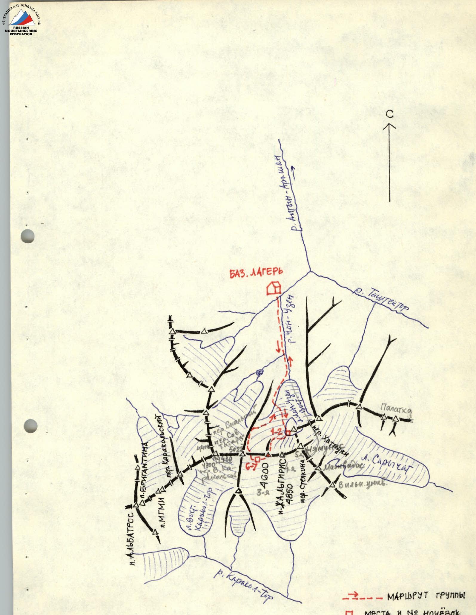
- Ascent Area: Tian Shan, Terskey Ala-Too, Chon-Uzen River Valley
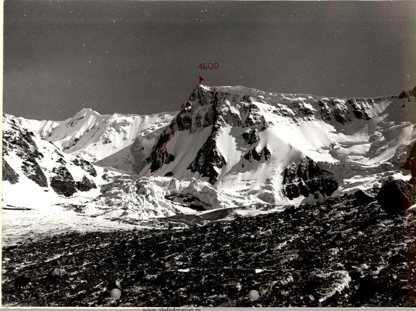
- Peak, its height, ascent route: Peak 4600 m via the NE buttress, proposed category 5B
- Route Characteristics:
height difference — 1100 m, route steepness 65°, section lengths:
- 2nd difficulty category – 70 m
- 3rd difficulty category – 160 m
- 4th difficulty category – 420 m
- 5th difficulty category – 400 m
- 6th difficulty category – 40 m
- Pitons Used:
| for belay | for artificial holds | for bivouac setup | |
|---|---|---|---|
| rock | 74 | 10 | 4 |
| ice | 20 | - | 3 |
| bolt | - | - | - |
- Total climbing hours: 57 hours
- Number of nights and their characteristics:
- 1–2 nights – on a destroyed ridge
- 3–4 nights – on a snowy ridge, 1 shoulder
- 5th night – on a snow shelf, 2nd shoulder
- 6–7 nights – in a snow hollow
- Surname, name, patronymic of the leader and participants and their qualification:
- Migla Aldis, CMS – leader
- Jurgelenis Julius, Pras, CMS – participant
- Tamulenaite Olga, Petro, CMS – participant
- Team Coach: I. Migla
- Date of departure and return: July 27, 1979 – August 3, 1979
Geographical Overview of the Area and its Sporting Characteristics
The Ak-Su wall, whose highest peak is the 4th peak named Peak Zhalgiris, is located in the eastern part of the Terskey-Ala-Too range, part of the Tian Shan mountain system. This range borders Lake Issyk-Kul to the south. It is home to well-known peaks such as Dzhigit (5170 m), Karakol (5280 m), the Dzhety-Oguz wall, and others. The Ak-Su wall closes the Altyn-Arashan valley and is located east of the well-known Karakol valley, where the "Ala-Too" alpine camp is situated.
The first ascent of Peak Zhalgiris was made on August 17, 1969, by participants of the II Lithuanian Alpinada. Two groups, led by V. Stepulis and R. Zdanavicius, reached the summit via the southeastern ridge, following routes categorized 3B and 4B. Since then, no one has climbed this peak.
No other peaks on the Ak-Su wall have been climbed by mountaineers.
The Ak-Su wall is located on the northern side of the range and is characterized by:
- significant glaciation;
- overhanging cornices;
- avalanche danger.
There are several interesting ice routes on the wall, including those to Peak Zhalgiris, which are still awaiting climbers.
Two rock buttresses stand out on the wall: the northeast and north buttresses, leading to the 3rd (unnamed) peak of the Ak-Su wall.
The remaining peaks not part of the Ak-Su wall are mostly unnamed and lack classified routes. They are lower and considered "simpler" in mountaineering terms. These peaks can be recommended for training and acclimatization ascents.
The Altyn-Arashan valley area is visible on the attached diagram. From a mountaineering perspective, the Tashtaktor river valley is also of interest, with several interesting peaks at its end, including:
- Peak Sov. Rossiya;
- and others.
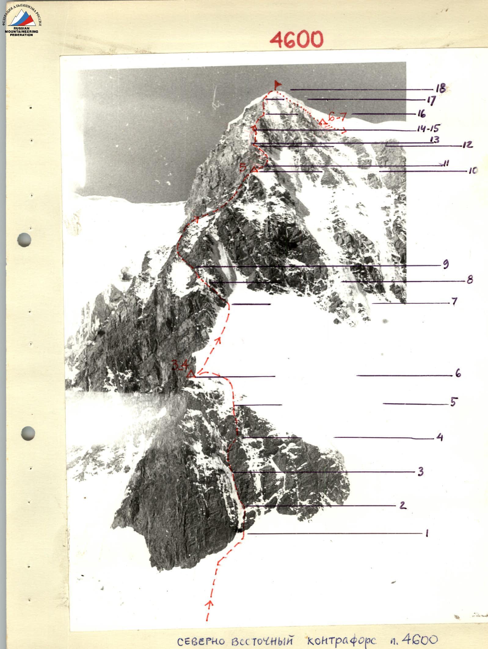
Northeast Buttress of Peak 4600

Profile of the Upper Part of the Buttress
Control Tours
Ascent Details
July 27, 1979. At 11:00, the group departed from the base camp at the confluence of the Takyr-Tor and Chon-Uzen rivers. They reached the Eastern Chon-Uzen glacier by 14:00. The path to the foot of the route went through the glacier, bypassing the first icefall on the left. Then, they traversed the scree of the destroyed ridge that divides the glacier into two parts. The second icefall was bypassed on the right. They climbed to the top of the icefall via the destroyed rocks of the ridge. On top of the icefall, on the rocks (scree) of the same ridge, they set up a bivouac. They arrived at the bivouac at 19:30. The altitude was 3500 m. The bivouac was near the route, with a good view of the lower part of the route and the ice-snow "comb" where they planned to set up their second bivouac.
July 28, 1979. A group member, A. Buika, fell ill. He was lowered to a bivouac by the lateral moraine of the glacier, where V. Bijsenas's group was still located. A. Buika descended to the base camp with one of V. Beisenas's group members. The rope team that accompanied A. Buika lightly climbed back up to the bivouac above the second icefall by 10:00. At 12:00, the duo – A. Migla and J. Jurgelenis – set off to process the route. They approached the route by crossing the glacier above the 2nd icefall. They climbed a snowy slope to the bergschrund, crossing it with simultaneous belay. The path then went up a steep ice slope. Two ropes (40 m each) led to an internal rock angle. The ascent continued up the internal angle – the rocks were heavily destroyed and icy, steep. The rope team passed two ropes up the internal angle and, leaving the ropes hung, descended to the bivouac by 19:00. They met the second group. During the ascent, they extended the control deadline to August 4, 1979.
July 29, 1979. The group departed for the route at 7:00 in the morning. They crossed the glacier, climbed the snowy slope to the bergschrund, and then continued up the ice slope. They quickly traversed the internal angle using the fixed ropes.
They then proceeded up the internal angle to the right onto a shelf, where it was possible to comfortably belay (1 rope). From the shelf, they climbed up a negative angle (good belay, ladders) and "emerged onto a not clearly defined ridge." They climbed the ridge (difficult climbing) to a rocky outcrop on an ice slope for 1.5 ropes.
They climbed a steep ice slope to the left to an ice-snow "comb." On the ice slope, they cut steps (1.5 ropes). Behind the "comb," they descended one rope to rocks, where they set up a bivouac. It was possible to set up a bivouac higher up on a snow shoulder, one rope higher. They reached the bivouac at 20:00; the weather was bad.
July 30, 1979. At 7:00, they began the ascent up the snow-ice "comb." In places, they had to cut steps. The belay was piton-based. They climbed three ropes. Everyone ascended wearing crampons. They continued to an ice couloir. Another rope led up a steep ice slope, requiring step-cutting. The belay was piton-based.
Bypass:
- They bypassed the ice couloir on the right.
- Attempted to ascend the rock wall to the "comb."
The climbing was very difficult. They decided to descend and seek a new path. They planned to ascend via the left side of the ice couloir. By 18:00, the group decided to return to the bivouac, leaving three ropes up to the ice couloir.
July 31, 1979. At 7:00, they ascended the fixed ropes to the ice couloir. At the foot of the ice couloir, they turned left onto rocks. The climbing was very difficult, with icy rocks (1 rope). They pulled up their backpacks.
The path then went up a rockfall-prone, wide couloir. In the middle of the couloir, water flowed. From the couloir, they emerged onto a "comb," transitioning into a wall in places. They climbed using difficult climbing techniques with piton belays. They reached a sloping snow shelf trending to the right (4 ropes).
They stopped for the night at 20:00.
August 1, 1979. They departed for the route at 7:00. They moved right onto the ridge. After 30 m, the ridge became overhanging. At this point, they turned right and climbed up a chimney. Then:
- 3 ropes up rocks;
- at the end – up an ice wall (about 3 m) to a gentle ice-snow shoulder on the ridge.
Here, they built a control cairn. From the shoulder, the ridge rose steeply. Initially, they climbed straight up the wall, which higher up turned into a sharp ridge. Before the second rise of the ridge, they turned left onto a good, wide, well-defined shelf (2 ropes).
This was a good spot for a bivouac. From the shelf, they climbed a wide couloir, staying to its right side. The rocks here were monolithic, with good handholds. The middle of the couloir was rockfall-prone. At the top of the couloir, they turned right onto the ridge (2 ropes).
They climbed icy rocks on the ridge – 1 rope. Then, they ascended a steep ice slope to a snow-ice cornice 2.5–3 m high.
On the upper part of the rocky ridge, they set up a good belay. The first climber, A. Migla, traversed the ice slope and broke through the cornice.
Beyond the cornice lay the ice-snow summit dome. To the left of the dome, there were rocks. They built a second control cairn on these rocks. By 18:30, they descended into a snow hollow and stopped for the night.
August 2, 1979.
- They waited for the second group, which was ascending the same route, maintaining communication.
- 20:00 – the second group reached the summit.
August 3, 1979.
- The second group, led by V. Shaduikis, made an ascent of Peak Zhalgiris and was back at the bivouac by 9:30.
- They dismantled the bivouac and descended together via the 4A category route, down a spur ridge onto the Eastern Chon-Uzen glacier.
They arrived back at the base camp by 18:00.
Group Leader
 A. Migla
Participants