
- Climbing category — technical
- Climbing area — Central Tian-Shan (Karakol)
- Peak, its height, route — Peak 4310 m, via the central NW buttress.
- Estimated category of difficulty — 3B.
- Route characteristics height difference — 510 m, average steepness — 45°, route length — 745 m
- Pitons driven rock — 10, chocks — 3, ice — 10
- Number of climbing hours — 8 hours
- Team composition: Solovyov Alexander Grigorievich — 1st sports category, captain Vodopyanov Sergey Konstantinovich — Candidate for Master of Sports, coach-observer Plotnikov Andrey Evgenievich — Candidate for Master of Sports, participant Eremin Vladimir Viktorovich — 1st sports category Gerasev Alexander Petrovich — 1st sports category Khaibulina Lyudmila Sultanovna — 1st sports category
- Team coach — Prokopenko Vladimir Ivanovich
- Date of ascent on the route and return — July 2, 1980
 P 4310. First ascent route. (— → — route of Belarusian climbers)
Description of the first ascent to Peak 4310 via the central
NW buttress, category 3B (approximately)
-
Information about ascents to the peak. There were no classified routes to Peak 4310 at the time of the ascent. There is unofficial information about ascents to this peak by Belarusian climbers, via the double-horned sentinel.
-
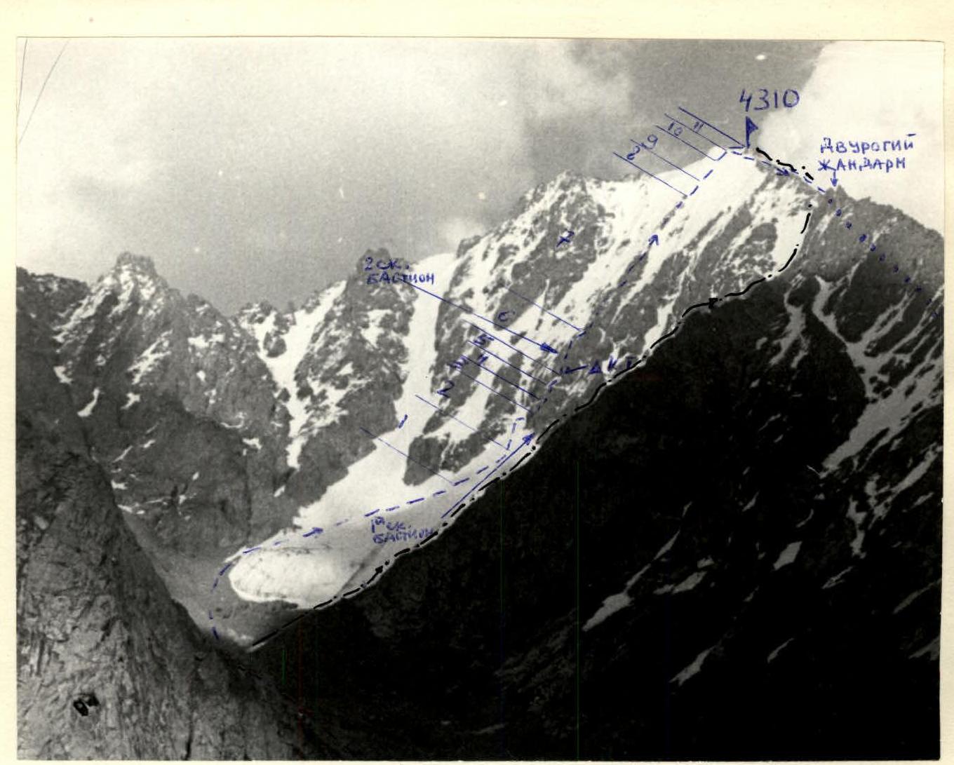
Location of the peak. The peak is located in a lateral spur of the Teskey Ala-Too ridge, branching off from Peak Jigit to the north. The first ascent route has a northwest exposure.
-
Approaches to the peak. From the location of the "Ala-Too" mountaineering camp (confluence of the Kel-Tor and On-Tor rivers) — along the trail upstream of the On-Tor River (along the left orographic bank) to a spring flowing from a lateral moraine (2–2.5 hours). From this point, the peak is clearly visible (to the east, see panorama), the route, and the ascent to the upper cirque of the peak. From the spring, up to the tongue of the "Karakol" glacier (1.5 hours). The river is crossed along the glacier tongue. It can be crossed in its upper reaches and in the early morning hours. Further movement is along the right (orographic) bank downstream to a steep scree slope descending from the cirque of Peak 4310 (opposite the spring mentioned above). Ascent to the cirque — along the moraine (to the left of the direction of travel) to the glacier. Ascent to the glacier is to the left (in the direction of travel) along the lateral moraine. Then the glacier is crossed from left to right in the direction of the peak, to the second short snow couloir, the right wall of which is the buttress of the first ascent (3–4 hours from the Karakol glacier tongue).
-
Route description. The lower part of the buttress is a 50-meter rock bastion. Ascent to it is to the left — along a gentle snow-ice couloir under the bergschrund (R1), from the bergschrund — straight up (30 m) and to the right (R2) under the right, steeply dropping, narrow ice couloir (R3, key point, regelation ice, insurance via ice and rock pitons). Ascent along the couloir, transitioning into a rock internal angle (R4), to a platform (top of the 1st rock bastion). From the platform, up and to the left along a gentle snow ridge (R5) under a chimney of the rock bastion. In front of the bastion, to the left on a shelf, a control cairn is built (ascent from the glacier takes 3 hours). There are loose rocks in the chimney!!! Ascent along the chimney (R6) to the second bastion (2nd key section, piton insurance and use of chocks). Further movement goes up along a rock ridge of medium steepness (R7, rocks are solid, many ledges, insurance via ledges). The rock part of the buttress transitions into:
- rock-snow (R8);
- then into ice (R9). Ascent to the summit part of the buttress — to the right of the blade of the buttress along steep ice (3rd key section) and snow. From the point of exit to the ridge to the summit — 60 m (5 hours from the control cairn).
Descent from the summit:
- from the summit — to the point of exit to the ridge;
- further along the western snow-rock ridge (2) to the double-horned sentinel (1 hour);
- then to the left (in the direction of travel) down along a scree couloir into the southern cirque of the peak;
- further down along scree slopes to the On-Tor River (3 hours from the summit). Time taken for the ascent — 13–14 hours. The route is objectively safe, cold. Possible overnight stops on the route:
- platform on the 1st rock bastion;
- on the summit.
Recommended equipment for a group of 4 people:
- Main rope — 3 × 40 m.
- Pitons rock — 10 pcs. ice — 6 pcs. chocks — 1 set.
- Carabiners — 10 pcs.
- Hammers — 2 pcs.
- Ice axes — 4 pcs.
- Primus stove — 1 pc.
- Warm clothing — 4 sets.
- Food — 1.5 days.
Table of main route characteristics
| Section # | Length in meters | Steepness in degrees | Category of difficulty | Pitons driven (rock/ice) | Brief characteristics |
|---|---|---|---|---|---|
| 1 | 150 | 30 | 2 | 1 | Snow-ice slope |
| 2 | 60 | 40 | 3А | 1 | Ice slope, covered with a thin layer of snow |
| 3 | 15 | 50 | 3Б | 3 | Ice couloir, regelation ice |
| 4 | 5 | 50 | 3Б | 2 | Destroyed rocks of the internal angle |
| 5 | 15 | 30 | 2 | - | Snow ridge |
| 6 | 40 | 80 | 3Б | 3/3 | Rock chimney |
| 7 | 300 | 40 | 3А | 1 | Rock ridge |
| 8 | 40 | 40 | 3А | - | Snow slope |
| 9 | 40 | 45 | 2Б | - | Ice slope |
| 10 | 20 | 40 | 3 | - | Snow slope |
| 11 | 60 | 20 | 1 | - | Snow ridge |
Description (according to UIAA) of the first ascent to Peak 4310 via the central NW buttress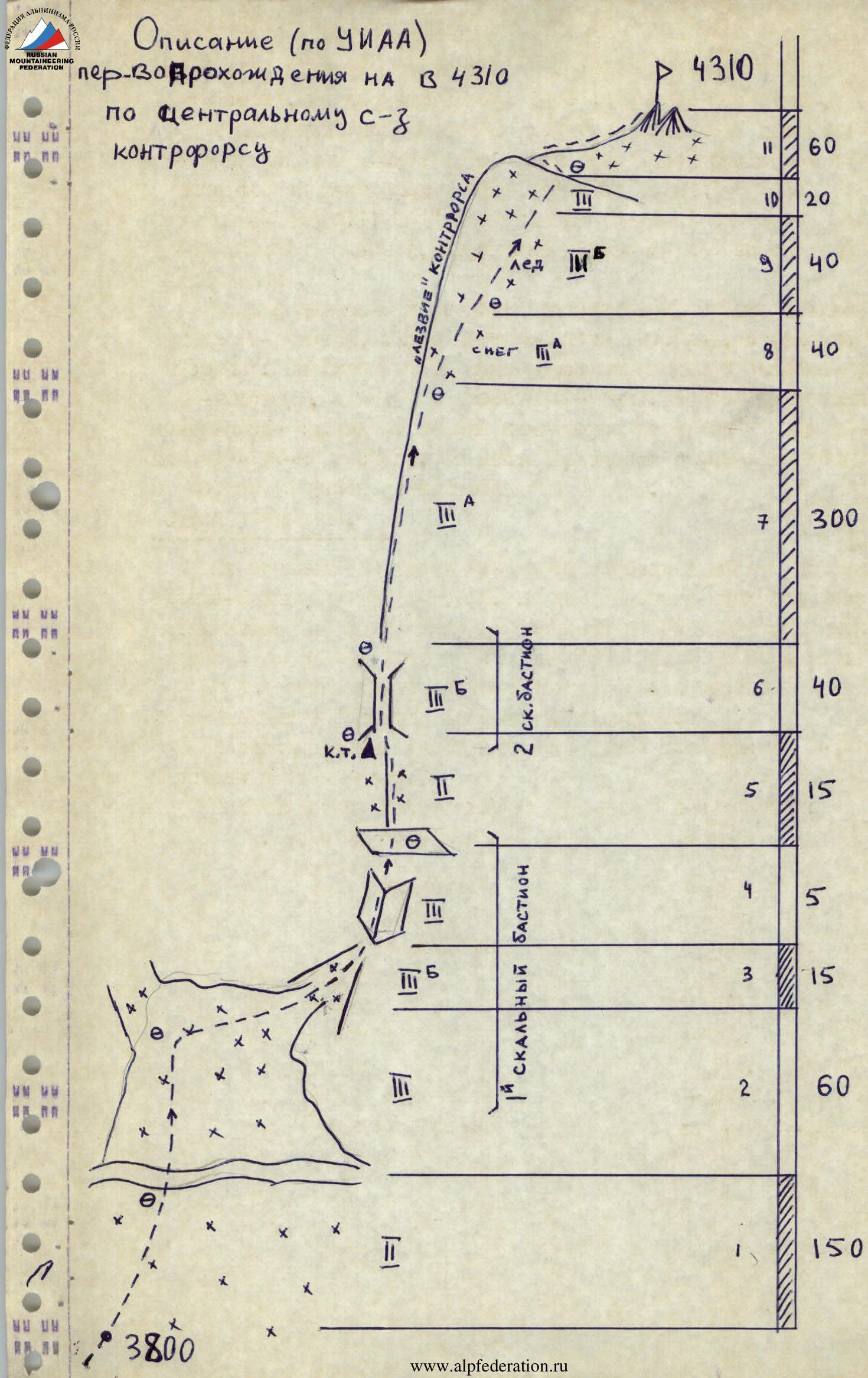
Map-scheme of the area
Comments
Sign in to leave a comment