
Ascent Passport
- Ascent class — technical.
- Region — Central Tien Shan, Terskey-Ala-Too ridge.
- Peak, its height and ascent route — Sherkhan Yuzhny, 4255 m, North-Eastern wall.
- Proposed difficulty category — 5B cat. diff.
- Route characteristics:
height difference 700 m, average steepness 68°, length of sections:
- I — none,
- II — none,
- III — 15 m,
- IV — 225 m,
- V — 540 m.
- Pitons hammered for belay: rock 68, ice 17.
- Departure and return date: departure from base camp July 11, 1977; return — July 13, 1977.
- Number of climbing hours — 31, including 23 hours on overcoming the wall.
- Number of nights and their characteristics:
two nights:
- 1st on moraine under the route;
- 2nd on the wall, sitting in a tent.
- Surname, name, patronymic of the leader, participants and their qualification: Makhnovich L.A., CMS — leader Gladchenko V.I., CMS — participant Zhurzdin V.I., MS — participant Penchuk V.L., MS — participant
- Coach Penchuk V.L. — MS.
Sherkhan Yuzhny, north-eastern wall
Profile photo of the upper part of the NE wall of Sherkhan Yuzhny peak.
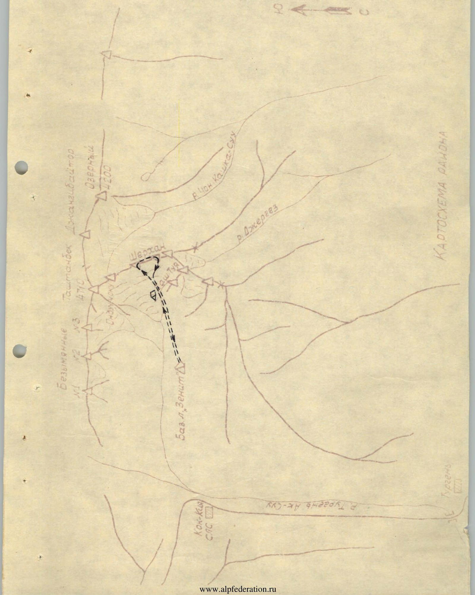
MAP OF THE REGION

Site 1.0×1.8 m (photo #5)
Brief description of the region
The Sherkhan Yuzhny peak is located in the Terskey-Ala-Too ridge (Central Tien Shan) on the territory of the Kyrgyz SSR and is one of the three peaks of the Sherkhan massif (Sherkhan Yuzhny, Central, Northern). The dominant peak of the region is Tashtambektorbashi — 4716 m (1948 — B. Marechek, 1953 — V. El'CHibekov). The Tashtambektor gorge region, which became the object of ascents of the MOS DSO "Zenit" mountaineering gathering in 1977, is relatively close to the well-developed Karakol region.
Approach to the Tashtambektor gorge:
- drive through the Turgen settlement to the Kok-Kiya avalanche station — about 50 km;
- from Przhevalsk and further 6–7 km upstream along the gorge — by pack transport.
However, despite its relative accessibility, a larger number of climbing objects, until now it has been visited by mountaineers only twice — in 1948 and 1953 — and is of undoubted interest from a mountaineering point of view.
The region is characterized by a very unstable and harsh climate due to the proximity of Lake Issyk-Kul. Good weather is rare. The usual weather cycle is as follows:
- 1 day of good weather;
- during the next 1–2 days — a steady deterioration of the weather;
- after that — bad weather for 5–7 days.
The high-altitude zone is characterized by constant strong air mass movement at speeds up to 15–25 m/s and unusually low temperatures.
Such extreme climatic conditions require thorough preparation for ascents and being prepared for any surprises. A significant part of the routes in the region are combined, with a large length of ice sections.
Preparation for the ascent
The main task of the MOS DSO "Zenit" mountaineers gathering in the 1977 season was to participate in the USSR championship and the team's ascents within the framework of the championship on the Tashtambe bektorbashi peak. The reconnaissance of the region was carried out in May this year by the gathering participants Penchuk V.L. and Zhurzdin V.I. When discussing the training plan and getting acquainted with the region, the gathering team (Gladchenko V.I., Zhurzdin V.I., Kuzmin A.S., Makhnovich L.A., Penchuk V.L., Podymov) paid attention to the Sherkhan Yuzhny peak, directly adjacent to the Tashtambe bektorbashi peak. The interest in this peak and the route to it along the North-Eastern wall was due to the similarity of the route to the Tashtambe bektorbashi peak along the Western wall, great difficulty and relatively short length. Thus, the ascent to the Sherkhan Yuzhny peak along the North-Eastern wall was supposed to be a "dress rehearsal" for the team.
The second factor that caused additional interest in the specified peak is that it had never been climbed before. Direct preparation for the ascent began with the functioning of the gathering in the Tashtambe gorge from July 5, 1977. Training sessions were held; rock, snow and ice training were conducted in the immediate vicinity of the Sherkhan peak. After reconnaissance of the route on ice training and a training ascent to the Tash-Tuya peak, the entire gathering team finally clarified the route, and the coaching council determined the composition of the group:
- Makhnovich L.A. — leader;
- Gladchenko V.I., Zhurzdin V.I. and Penchuk V.L. — participants.
All the listed participants are well acquainted with each other and have made ascents of the highest difficulty categories in various combinations:
- Dykh-Tau;
- Mamisond;
- Dombai-Ulgen, including along the wall of the CSA (Caucasus);
- p.p. Litva and Moskovskoi pravdy;
- Kommunisticheskoi Akademii (Pamir);
- p. Dzhigit (Terskei-Ala-Too);
- and others.
Some of these ascents were made within the framework of the USSR Championships, the championships of Moscow and the CS DSO "Zenit" and "Trud". Ascents in the Tien Shan and Bezengi regions gave the group members experience working in harsh climatic conditions.
Route clarification and tactical plan
The wall, when viewed, resembles a triangle. The right part of the wall is bounded by steep avalanche-prone ice fields. The left part of the wall is a highly dissected group of vertical walls, very dangerous due to rockfall.
The most logical seems to be movement along the center of the wall — this path, as observation showed, is the safest. The route along the wall can be conditionally divided into two parts:
- The lower part is a rocky section of great steepness with a small number of holds, the rocks are monolithic and smooth large-block structure. There are few loose stones due to the great steepness, and the direction of their fall is the left part of the wall.
- The upper part is rock-ice, requires great attention, caution and observation when passing.
Probable places for overnight stays — after the first third of the route and before the summit tower.
Taking into account the available information, the following tactical plan was outlined:
- Approach to the route and observation of it during the day.
- Early exit and overcoming the wall within two days with an overnight stay before the summit tower.
- Descent through the Sherkhan Central peak.
As an alternative, an overnight stay halfway and one reserve day were provided.
In order to reduce the weight of backpacks, special attention was paid to the selection of equipment and food. High-calorie food, lightweight kitchen equipment, titanium crampons, shared down equipment, and other measures made it possible to have an initial backpack weight at the start of no more than 8–10 kg.
To increase the reliability of the route, it was planned to use mainly ice screws for the main belay points.
Given the great experience and ability to work on rocks of all group members, a leader was not assigned. Uniform work was expected from all participants. Ropes: Makhnovich — Zhurzdin, Gladchenko — Penchuk. Group safety was ensured by:
- a rescue team at the base camp;
- interaction with the Kukushkin group, going along the ridge to the Sherkhan Central peak at the same time;
- interaction with two other groups on ascents in this region;
- radio communication.
Table of main characteristics.
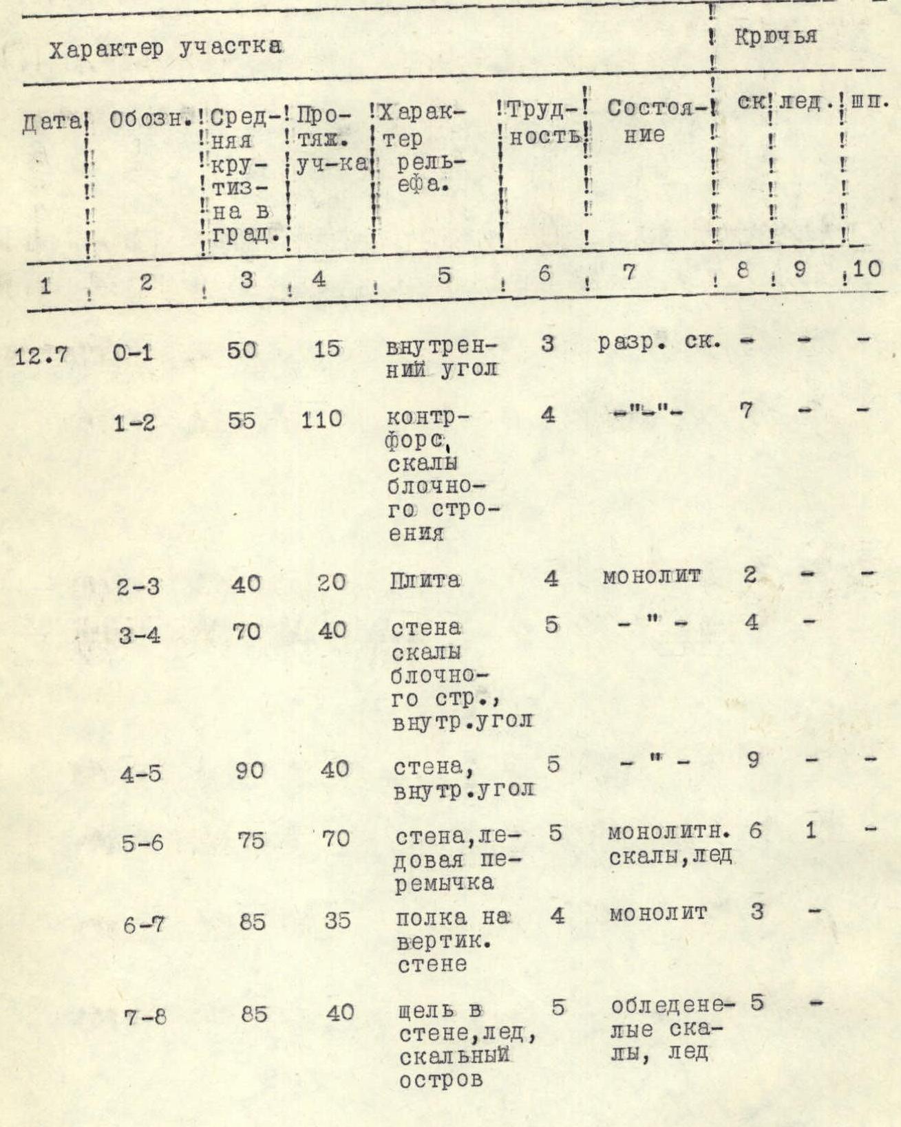
| Date | Section | Average steepness (in degrees) | Length of section (m) | Terrain character | Difficulty | Condition | Rock pitons | Ice pitons |
|---|---|---|---|---|---|---|---|---|
| 12.07 | R0–R1 | 50 | 15 | Inner corner | 3 | Broken rocks | — | — |
| R1–R2 | 55 | 110 | Counterfort, blocky rocks | 4 | — | 7 | — | |
| R2–R3 | 40 | 20 | Slab | 4 | Monolithic | 2 | — | |
| R3–R4 | 70 | 40 | Wall, blocky rocks, inner corner | 5 | — | 4 | — | |
| R4–R5 | 90 | 40 | Wall, inner corner | 5 | — | 9 | — | |
| R5–R6 | 75 | 70 | Wall, ice bridge | 5 | Monolithic rocks, ice | 6 | 1 | |
| R6–R7 | 85 | 35 | Shelf on vertical wall | 4 | Monolithic | 3 | — | |
| R7–R8 | 85 | 40 | Crack in wall, ice, rocky island | 5 | Icy rocks, ice | 5 | — | |
| R8–R9 | 65 | 180 | Rock-ice section of wall | 5 | Ice, icy rocks | 12 | 14 | |
| R9–R10 | 45 | 30 | Ice, rocks | 5 | — | 2 | 2 | |
| R10–R11 | 70 | 55 | Inner corner of wall | 5 | Monolithic | 5 | — | |
| R11–R12 | 45 | 60 | Summit tower, traverse along shelf | 4 | Destroyed shelf, ice, rocks | 5 | — | |
| 13.07 | R.E. | R12–R13 | 80 | 85 | Wall | 5 | Monolithic | 8 |
Description of the route passage
The approach to the route is not long: from the base camp on the Tashtambe glade — 2 hours. Movement along the right side upstream in the direction of the Tashtambe glacier to the lateral moraine (1 hour), then, crossing the moraine from right to left, exit to the glacier (20 min). The glacier is closed, belay is necessary here and continued movement under the route, sticking to the slopes of the Sherkhan massif.
The route begins at the base of the walls, in its lowest part.
July 11. Departure from the base camp at 10:06. At 11:30, we reached the lateral moraine of the Tashtambe glacier and set up a camp. The Makhnovich — Gladchenko rope went to the base of the route for observation. Observation continued until 17:00 and confirmed the initial tactical plan. The only clarification was that the supposed overnight stays did not guarantee good sites. Significant work was required to organize a bivouac (observations). Radio communication with the base camp during the day showed reliable operation of the "Vitalka" type radio station. Dinner and early bedtime.
July 12. Rise at 3:00. Packing and departure to the glacier at 4:00. At 5:00 — approach to the route and start of movement. The Makhnovich — Zhurzdin rope begins processing, with Zhurzdin leading. R0–R1. Along the inner corner, rocks are destroyed, of medium difficulty, exit to the wall (50°, 15 m).
R1–R2. Counterfort of the wall, cross movement upwards to the left, rocks of medium difficulty (55°, 110 m, 7). Movement of ropes is independent. Many live stones. Caution is required when moving. R2–R3. Slab (40°, 20 m, 2). There are practically no ledges. The section is confidently passed by Zhurzdin and he hangs the belay. Movement along the belay upwards to the right. R3–R4. Inner corner (photo 3) (60°, 20 m, 2). Continuation of movement upwards to the right, exit to a vaguely expressed ridge, turn along it upwards to the base of difficult rocks (80°, 20 m, 2). After a difficult section, the shelf goes to the right and upwards at an angle of 30° to the waterfall. The waterfall remains on the right, in the shelf there is a crack 10 cm wide. Attention! There is a control tur in the crack under the waterfall.
R4–R5. Change of leader, Gladchenko goes first. Very difficult section. Vertical wall (photo 4), rocks are monolithic, few cracks. Movement is possible by traversing to the left and upwards at an angle of 30° to the base of the inner corner (90°, 20 m, 5).
- Inner corner, difficult climbing (90°, 20 m, 4).
- This section is passed without backpacks.
- After passing, they are pulled up.
- At the end of this section, after 1–2 hours of work, it is possible to set up a site.
However, we decided to go further. The beginning of the route was passed energetically. The physical condition of the participants is excellent. Time is 12:00. Radio communication with the base camp and the Kukushkin group going along the parallel edge. Everything is normal. Short rest, snack, continue movement.
R5–R6. Change of leader, Makhnovich goes first. Vertically upwards along the wall (80°, 50 m, 6), exit to the ice bridge (20°, 20 m, 1). The ice bridge leads to the next wall with a steepness of 85–90°.
R6–R7. Movement bypassing the wall along a weakly expressed shelf, at first almost horizontal traverse (20 m, 1), then to the left and upwards along the rock-ice shelf 15 m to the base of the next wall (2).
Water is seeping along the entire wall and rockfall is possible from above. Therefore, the passage is extremely cautious with observation. Belay point is above when receiving lower participants under the negative part of the wall.
The seventh section completes the rocky section of the wall. Next begins the rock-ice part.
R7–R8. Traverse of the wall to the right and upwards along the crack (90°, 20 m, 1) and exit to rocky islands embedded in ice (90°, 20 m, 4).
R8–R9. Change of leader, Gladchenko goes first again — rock-ice section, difficult climbing. Movement along the center of the wall along alternating rock-ice sections straight up with small zigzags to reduce the danger of possible stones from the leader. Rocky sharp formations are monolithic smoothed blocks like "ram's foreheads", with a steepness of 70–90°. There are few places for pitons. In the course of the movement, ice pitons are used to increase reliability, hammered into rocks. Movement along the belay with utmost caution (65°, 180 m, 12 rock and 14 ice pitons). The ninth section leads to the base of the summit rocky tower, the ice ends, but the exit to the summit tower is very complicated. In the middle of the ice section, the leader is changed.
R9–R10. Traverse of the ice section (45°, 30 m, 2 rock, 2 ice pitons), upwards to the right from the rocky island to the base of the tower, which has the form of a wide angle at this point, leads to the emergence of a pendulum, movement along which along the belay even with light backpacks is very difficult, but the physical condition of the participants allows for confident passage. Only the leader's backpack was pulled up.
R10–R11. Change of leader, Zhurzdin goes first. Exit to the shoulder without backpacks (80°, 40 m, 4), then receiving backpacks and movement to the left and upwards along the shoulder (45°, 15 m, 1).
R11–R12. Movement along a vaguely expressed rocky shelf, partly covered with ice and snow, to the left and upwards (at an angle of 30°) bypassing the summit tower (45°, 60 m, 5). At the end of the section — a small oblique shelf, after an hour of processing it was possible to set up a tent for a sitting overnight stay (site 1.0×1.8 m, photo #5). Securing the tent, placing in it and preparing a hot dinner took a long time. Lights out were given after 12:00. However, despite the almost twenty-two-hour working day, the ascent was scheduled for early morning. The reasons for this were very serious:
- in the second half of the day, the weather started to deteriorate;
- experience of staying in this region showed that the weather deteriorates for a long time.
July 13. Rise at 3:30, packing, dismantling the site, preparation and departure. Morning inspection showed that there were 80–100 m to the summit, but climbing was very difficult. R12–R13. 6:00. Zhurzdin goes to process the route without a backpack, exit to the summit along rocks along the border of ice and talus (80°, 85 m, 8). Total group movement time on the final section — 3 hours.
As expected, there was no note on the summit. This fact and the absence of indications of an ascent to this peak according to the region's documents confirm that we have made a first ascent.
From the summit, 40 m — traverse along the snow-ice bridge towards the ridge leading to Sherkhan Central. Movement along the ridge is not difficult, simultaneous, lasting 1 hour.
Our assumptions about the onset of bad weather were justified, it is good that the main difficulties were already behind. Squally wind, dry snow and lack of visibility significantly complicated further movement, but an alarming message from the base camp about an incident in the Ordi group obliged us to continue movement, despite the conditions.
Descent from the summit of Sherkhan Central along the Kukushkin group's route was organized and completed by 16:00.
Route assessment and recommendations to climbers
According to the unanimous opinion of the group and, after debriefing, according to the assessment of the coaching council, the head of rescue and the route issuer, the route deserves 5B cat. diff. and is similar in character to the Georgian route on Dykh-Tau. The abundance of technically complex sections is not less, only they are concentrated on a shorter length. There are practically no easy sections on the route, and one has to move constantly in tension.
The recommended place for a bivouac (sitting) is in the area of R4–R6.
When reaching R4–R5 by 12:00:
- a strong group can continue the ascent to a bivouac in the area of R11–R12.
In other cases, it is advisable to stop for an early bivouac with simultaneous processing of the subsequent part of the route.
Recommended equipment:
- Crampons — for all participants;
- Rock pitons — 25–30 pcs.;
- Ice pitons — 10–12 pcs.;
- Public carabiners — 15–18 pcs.;
- Auxiliary rope — 40 m.
Appendix
Profile scheme of the route
Comments
Sign in to leave a comment