Ascent Passport
I. Class: rock.
2. Region: Terskey Ala-Too ridge, Tashtambektor gorge.
3. Peak, its height, route: Central Sherkhan, 4220 m, via the Eastern ridge.
4. Estimated category of difficulty: 3B.
5. Characteristics:
height difference: 400 m,
average steepness: 40°,
length of 5B sections: none.
6. Pitons hammered:
rock: 9 pcs.,
ice: none,
bolt: none.
7. Number of climbing hours: 12.5 hours.
8. Number of overnight stays: no overnight stays.
9. Team name: Zenith Sports Club team.
10. Full name of the team leader, participants, and their qualifications:
Kukushkin Anatoly Fedorovich: 1st sports category, team leader,
Kremena Valery Petrovich: Candidate for Master of Sports, participant,
Kuzmin Anatoly Sergeevich: Candidate for Master of Sports, participant,
Romanov Alexander Alexandrovich: 1st sports category, participant.
II. Team coach: Kremena V.P.
12. Date of departure and return: July 12, 1977.
Brief geographical description of the ascent area
The ascent area is located in the Terskey Ala-Too ridge and is situated southeast of Lake Issyk-Kul. The proximity to such a large body of water explains the unstable weather with abundant precipitation and strong winds. Therefore, the routes are mostly combined with long snowy and icy sections.
Brief description of the ascent conditions
The base camp is located on the left (orographic) bank of the Tashtambek River, opposite Peak Panoramny. It is convenient to reach the base camp.
From Przhevalsk to the Kок-Kiya snow avalanche station, there is a good road leading to Sarydzhas.
From the snow avalanche station, after crossing the river (fording, on horseback, or by car), it takes 1.5 hours to reach the base camp along the left (orographic) bank of the Tashtambek River.
In the Tashtambektar gorge, trees grow only at the bottom. The camp is located on an alpine meadow. Approaches to the routes take no more than 2-3 hours.
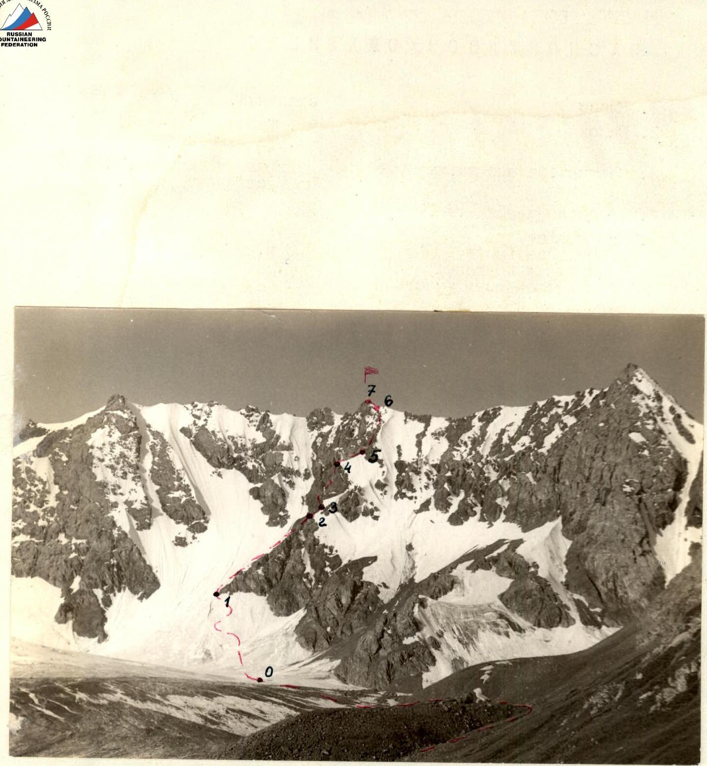
The Central Sherkhan peak (4220 m) is located in the center of the massif, north of the Tashtambek peak (4700 m), and closes the Tashtambektar gorge from the west. The Central Sherkhan peak slightly rises above the ridge. The entire route is clearly visible from the base camp.
Radio communication is provided by the "Vitalka" radio station directly from the base camp throughout the entire route.
The path initially passes along the grassy slopes on the left (orographic) side of the Tashtambektar gorge, then along the moraine of the North Tashtambek glacier. It takes 2 hours from the base camp.
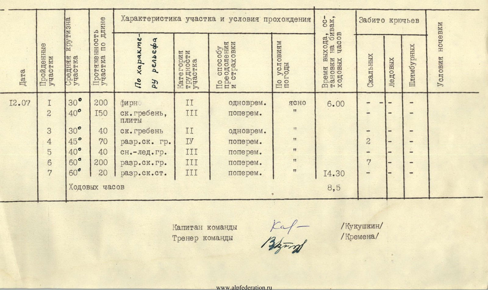
Brief description of the route
Before entering the closed glacier section, it is necessary to rope up. Then, along a gentle firn slope (30°, 200 m), to the Eastern ridge of the Central Sherkhan peak. It takes 2 hours 30 minutes from the base camp. Then, along the left side of the ridge, with a subsequent exit to the crest. Particular caution is required as the rocks are heavily destroyed, and the entire route is prone to rockfall. The crest rocks have a slab structure, and piton protection is necessary in some areas. Along simple rocks (40°, 150 m), there is an exit to the snowy crest (30°, 40 m). Further, along rocks of medium difficulty (with piton protection on complex sections), there is an exit to an overhanging rock, which is bypassed on the left (45°, 70 m). Then, along the snowy-icy crest (40°, 40 m) and rocks of medium difficulty (60°, 200 m), there is an exit to the crest of the massif to the right of the Central Sherkhan peak. The ascent along the destroyed rocks (60°, 20 m) leads to the Central Sherkhan peak. It takes 8 hours 30 minutes from the base camp.
The descent is via the ascent route, taking 4 hours.
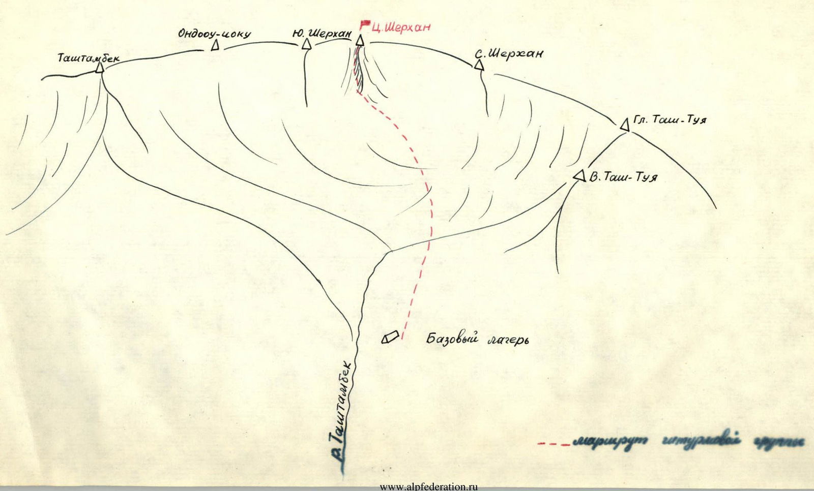
Table of main characteristics of the ascent route
Ascent route - Central Sherkhan peak via the Eastern ridge
| Date | Section | Section characteristics | Category of difficulty | Method of overcoming and protection | Weather conditions | Time of departure, stop for bivouac, climbing hours | Rock pitons | Ice pitons | Bolt pitons |
|---|---|---|---|---|---|---|---|---|---|
| average steepness, ° | length, m | terrain characteristics | |||||||
| 22.07 | R0–R1 | 25 | 120 | ridge | 2A | destroyed | overcast 6:30 | 13:30 (7 hours) | 7 |
| R1–R2 | 30–35 | 350 | sn.-ice. slope | 3B | ice with crevasses | " | 8 | ||
| R2–R3 | 10 | 200 | sn.-ice. ridge | 2A | snow, ice, crevasses | " | — | ||
| R3–R4 | 20 | 40 | sn.-ice. slope | 2B | " | " | 1 | ||
| R4–R5 | 35 | 40 | ice wall | 4A | ice | snow started | 4 | ||
| R5–R6 | 30 | 100 | sn.-ice. ridge | 3B | snow, ice | blizzard | 4 | ||
| R6–R8 | — | 60 | sn.-ice. plateau | — | " | " | — | ||
| 24.07 | R7–R8 | 20 | 200 | sn. slope | 2A | loose snow | overcast 6:00 | 20:00 (14 hours) | — |
| R8–R9 | 40 | 60 | ice slope | 4A | hard ice | " | 3 | ||
| R9–R10 | 25–30 | 400 | sn.-ice. slope | 3A | ice | " | 3 | ||
| R10–R11 | 50 | 40 | rock ridge | 2B | destroyed | " | — | ||
| Total: | 23 |
Team captain: /Kukushkin/ Team coach: /Kremena/ Climbing hours: 8 hours 30 minutes