
Ascent Passport
- Class — technical.
- Region — Tashtambektor gorge, Terskey-Alatoo.
- Traverse of peaks: Severny Sherkhan — Tsentralny — Yuzhny Sherkhan (about 4220 m) — Ondouuchoku (about 4350 m) with ascent to Severny Sherkhan via the Eastern counterfort.
- Estimated difficulty category — 5B, first ascent.
- Characteristics: height difference — 650 m; average steepness — 55°; length of sections with 5th category difficulty — 325 m.
- Pitons hammered for belay: rock — 28 pcs., ice — 3 pcs., bolted — none.
- Departure date — August 1, return date — August 3, 1977.
- Number of climbing hours — 19, including 13 hours for the ascent via the Eastern counterfort.
- Number of nights: two on the moraine below the beginning of the counterfort.
- Group composition: Ivanchin I. A. — Candidate Master of Sports — leader; Kukushkin A. F. — 1st sports category; Romanov A. A. — 1st sports category; Ryabov N. A. — 1st sports category; Starikov G. A. — Candidate Master of Sports.
- Coach — Penchuk V. L., Master of Sports of the USSR.
The 1977 climbing season for the Moscow Regional Council of the Zenit Voluntary Sports Society (DSC) focused on the eastern part of the Terskey-Alatoo ridge, in the upper Tashtambektor gorge. This area saw its first ascent to the Tashtambektor peak (4710 m).
Previously, this high-altitude region was visited only twice:
- in 1953 — by Uzbek climbers led by V. Elchibekov;
- in 1948 — by a group of Kyrgyz climbers led by B. Marechek.
Both groups ascended from the Kaska-Suu gorge, i.e., from the northwest. The region's weather conditions are similar to those of the Central Tian Shan, characterized by highly unstable weather:
- frequent precipitation;
- sharp temperature changes (even in mid-July, significant snowfall occurred in the base camp, temporarily halting the ascent);
- strong northwest winds, reaching hurricane force at higher elevations.
This area is harsher than the Karakol gorge.
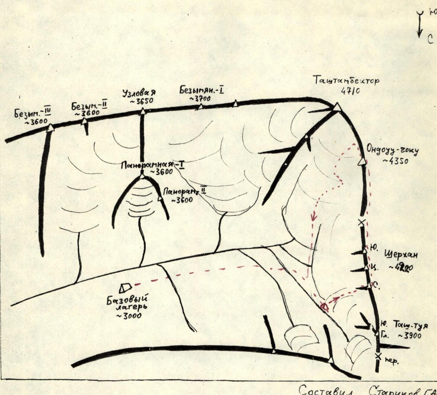
Travelling east from Przhevalsk, one can reach the snow-lavine station (SLS) below the Chon-Ashak pass by car in 2 hours and 30 minutes via highway and mountain road. From there, the Tashtambektor gorge is visible, and along the right side of the river, a good trail leads to the base camp location in 2 hours, situated at an altitude of 3000 m, 40 minutes short of the glacier tongue.
From here, the Eastern and North-Eastern slopes of the main peak in the area, Tashtambektor, as well as the Sherkhan massif, Tash-Tuya peak, and Panoramic I and II peaks are fully visible — refer to the map-scheme and photo I.
- Map-scheme of the Tashtambektor gorge area.
Ascent Description
The entire ascent route was visible from the base camp:
- the Sherkhan massif;
- the Eastern counterfort of its Northern peak;
- the entire ridge to the Ondouuchoku peak;
- the descent path to the glacier.
August 1. The group approached the start of the route (2 hours) and set up a bivouac on the lateral moraine of the glacier. From here, it was convenient to observe the state of the lower part of the Eastern counterfort, especially the rock slabs at the beginning of the route, to assess rockfall danger and determine a safe ascent path.
August 2. Considering the weather conditions in the given mountainous region, with frequent thunderstorms in late July, the lower rock slabs were processed, and 160 m of rope were fixed. Climbing was difficult in galoshes and sneakers. The Starikov-Ryabov team worked from 8:30 to 13:00 (sections R0–R8).
The remaining participants continuously observed the entire ascent route, traverse, and descent, particularly the descent via the steep glacier below the Tashtambektor peak, considering the challenging snow and ice conditions of the season.
During the processing of the lower part of the counterfort and observation, the chosen route and its safety were confirmed.
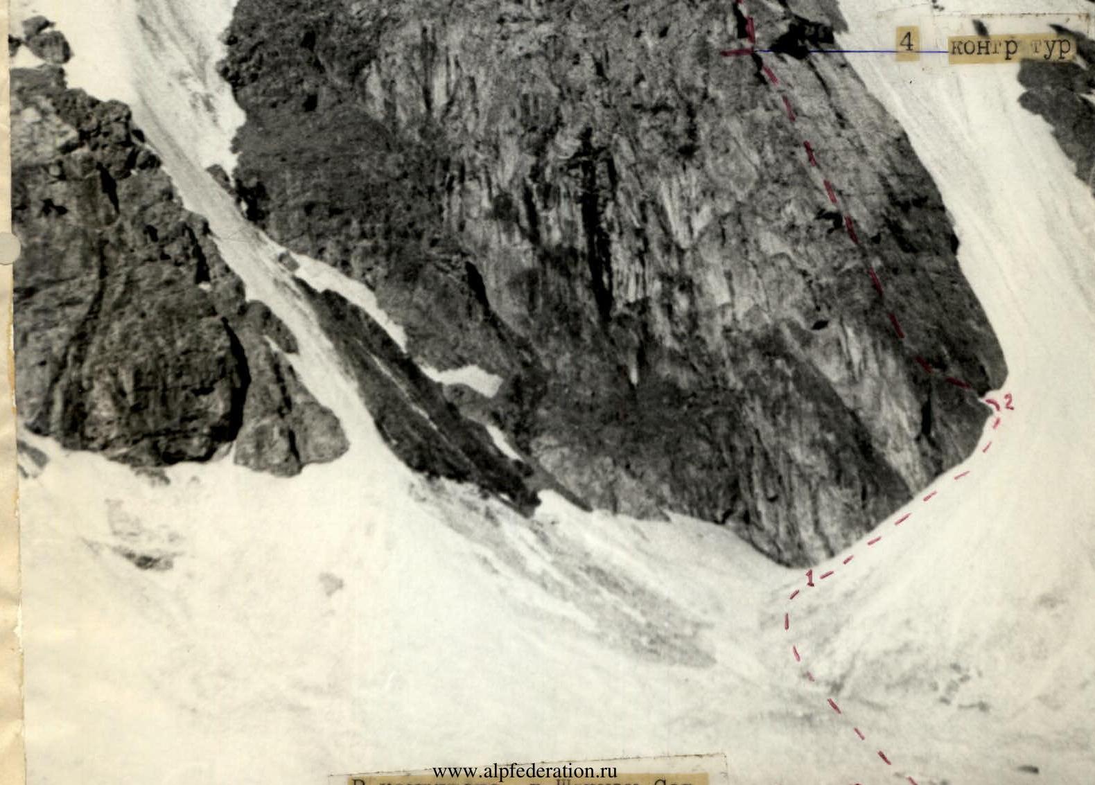
The lower part of the counterfort consists of a system of overlapping rock slabs with a steepness of about 50°, bounded on the left by an almost sheer, destroyed wall, and on the right by a very steep ice chute — a collector of all stones falling from the middle part of the counterfort.
August 3, 1977. The group in full, with bivouac gear, started the ascent, planning to complete the planned traverse in two days.
The following rope teams were formed: Starikov–Ryabov, Ivanchin–Romanov–Kukushkin.
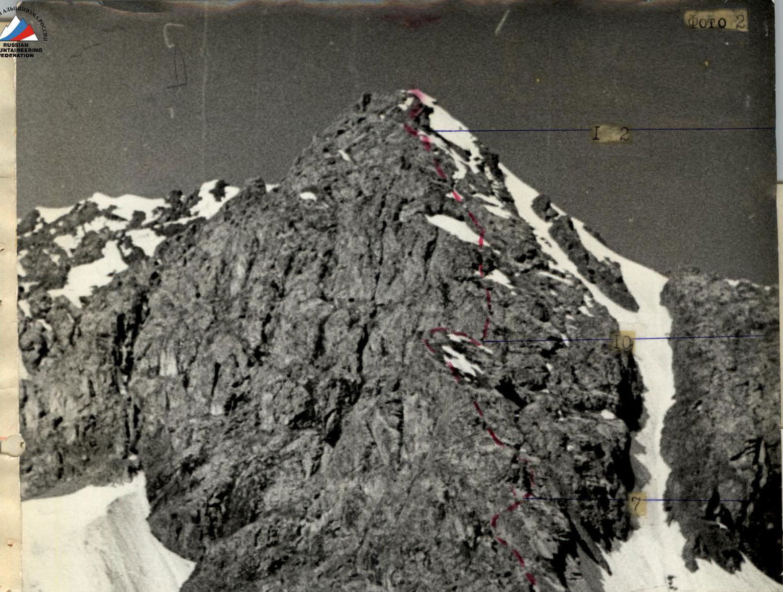
During the ascent via the counterfort, the first rope team did the main work.
Footwear: galoshes and sneakers. The lead climber in the rope team went with a lightened backpack or without a backpack, and the first in the trio (Romanov) wore vibram boots. Interaction between rope teams was significant, with movement on fixed ropes using jumar clamps, providing additional insurance and maintaining a decent group pace.
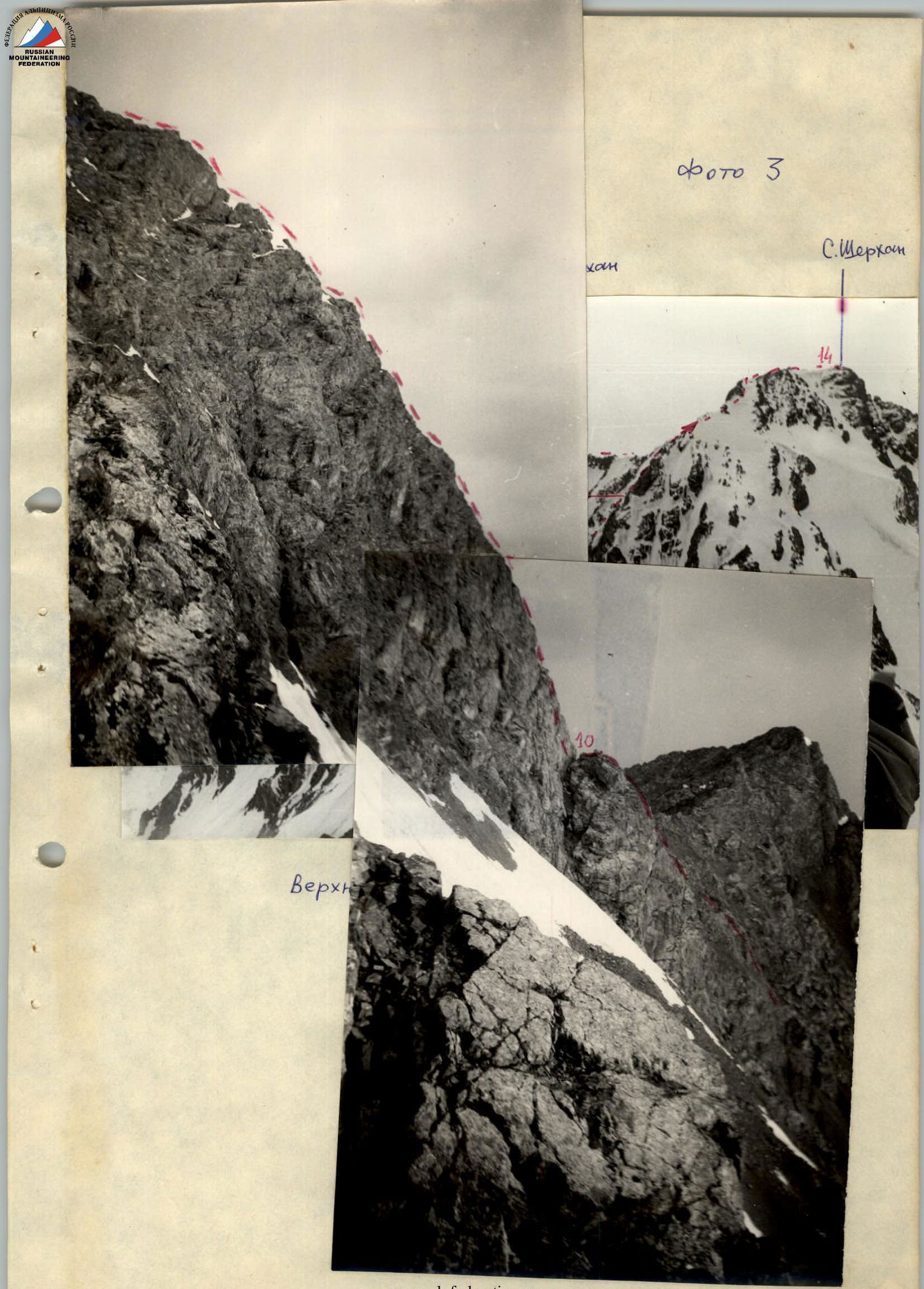
In the upper part of the counterfort (section R13–R14), movement was done in independent rope teams, as was the entire further traverse of the ridge to the Ondouuchoku peak.
The technical characteristics of the ascent are given in Table 1. Passing the counterfort after preliminary processing on the ascent day took 8 hours.
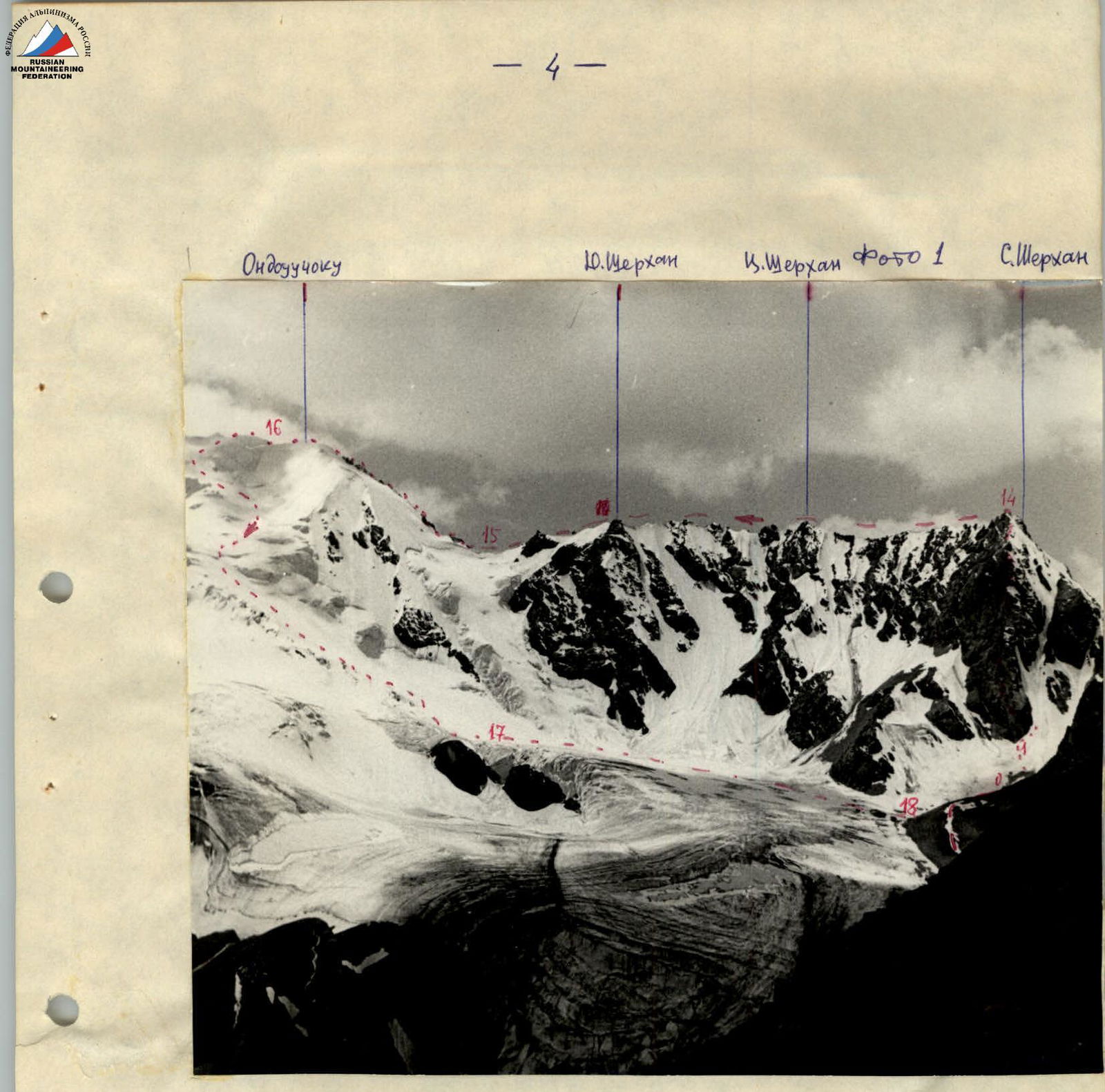
The traverse of the Sherkhan massif ridge in a southerly direction and further to the Ondouuchoku peak was a first ascent for the group. The ridge presented no particular difficulties, although it had several sections of 4th category difficulty. From the Northern peak to the Southern peak, the group took 2 hours and 30 minutes.
The weather, as expected, did not deteriorate significantly after noon: it was foggy, with occasional snowfall, but mostly with clear visibility up to the Tashtambektor peak. These conditions allowed the group to accelerate through the route. The group decided to complete the traverse and descend to the glacier before the end of the day.
The ascent to the Ondouuchoku peak was quite challenging: an ice climb, a 35 m rock chimney, icy rocks of 4th category difficulty, and took an additional 2 hours. They reached the summit at 16:30. On section R15–R16, the Ivanchin–Kukushkin–Romanov trio worked ahead.
On the Ondouuchoku peak, a note from V. Elchibekov's 1953 group was found in a cairn (see appendix).
The group decided to descend from the peak to the glacier via a previously reconnoitred path by our team's group (V. Zhurzdin), leading down the steep icefall of the Tashtambektor peak. The snow and ice conditions on the descent path were checked and presented no objective danger.
The group descended to the glacier by 19:00 with thorough belaying, including through ice screws, and returned to the base camp by 22:00.
This ascent concluded the sporting work of the 1977 MOS DSO Zenit gathering.
The quick traverse was made possible by the high acclimatization and sports preparation of all group members, who had previously completed very complex and labor-intensive first ascents to Tashtambektor peak, 5B category difficulty.
Overall, this ascent corresponds to a series of similar classified ascents of 5B category difficulty (Che-Guevara — SAGU). The counterfort's wall section is comparable to the Northwest wall of Western Dombay.
Description compiled by G. Starikov
| Date | Designation | Average steepness in ° | Length in m | Character of relief | Difficulty | State | Weather conditions | Pitons for belay |
|---|---|---|---|---|---|---|---|---|
| rock | ||||||||
| 1 VIII | Approach and observation of the route, path selection | trail, moraine | excellent | |||||
| 2 VIII | R0–R1 | 25 | 200 | snow slope | 1 | good | 6 | |
| R1–R2 | 35 | 80 | rock – slabs | 2 | firm | 1 | ||
| R2–R3 | 50 | 70 | inner corner | 3 | ||||
| R3–R4 | 60 | 10 | 4 | |||||
| R4–R5 | 60 | 10 | 4 | |||||
| R5–R6 | 45 | 30 | shelf | 5 | partially destroyed | 2 | ||
| R6–R7 | 90 | 15 | slab and wall | 5 | firm | 2 | ||
| R7–R8 | 50 | 25 | slabs | 4 | 3 | |||
| 3 VIII | R8–R9 | 50 | 80 | slabs | 4 | 3 | ||
| R9–R10 | 15 | 15 | ridge | 2 | 1 | |||
| R10–R11 | 80 | 110 | wall 10 m, inner corner, couloir | 4–5 | with individual rocks | 5 | ||
| R11–R12 | 50 | 130 | rock rib with snowfields | 3 | 3 | |||
| R12–R13 | 45 | 40 | bypass to the left of the red "gendarme" | 4 | destroyed | loops, protrusions | ||
| R13–R14 | 45 | 160 | rock-snow ridge | 3–4 | fog | |||
| R14–R15 | traverse | 2000 | rock ridge with towers, dips, etc. | 3–4 | fog | |||
| R15–R16 | ascent 50 | 300 | snow-ice climb, rock chimney, rock-ice slope, snow ridge | 4 | rocks icy | fog, snow | 11 | |
| R16–R17 | 30 | ~1500 | snow-ice slopes of the icefall | 4 | ||||
| R17–R18 | 15 | ~2000 | along the glacier to the moraine | 1 | good | |||
| Total: | 26 |
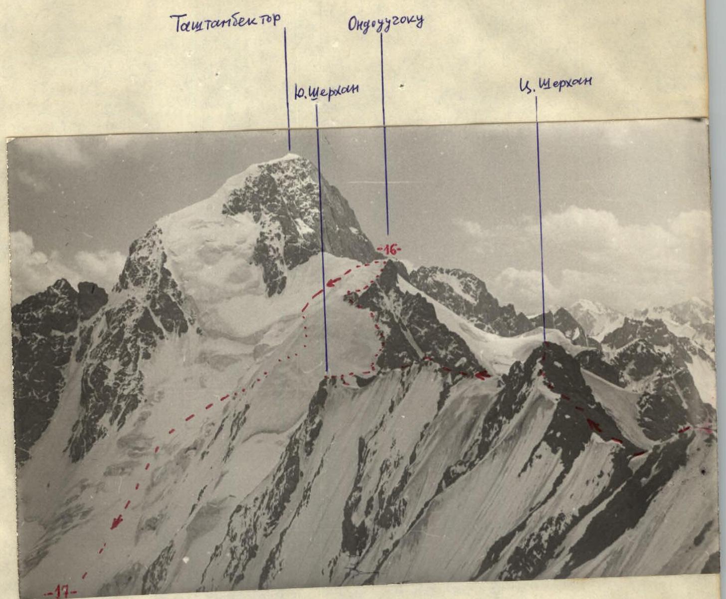 Ridge towards Tashtambektor peak (sections R14–R17).
Comments
Sign in to leave a comment