Climbing Passport
- CLIMBING TYPE: technical.
- CLIMBING AREA: Terskey-Alatau in the upper reaches of the Turgen-Aksu river.
- PEAK, ITS HEIGHT, CLIMBING ROUTE: Tashtambektor, 4710 m, via the NW buttress of the 103 ridge.
- PROPOSED DIFFICULTY CATEGORY: 5B.
- ROUTE CHARACTERISTICS: height difference — 1090 m, length of sections with 5–6 difficulty grade — 610 m, average steepness of the route 60° (excluding the horizontal ridge section).
- Number of pitons used:
| for belay | for artificial footholds | for organized bivouacs | |
|---|---|---|---|
| rock | - | 74 | 12 |
| ice | - | 31 | 9 |
| boulder | - | - | 4 |
- TOTAL WALKING HOURS: 57 h.
- NUMBER OF NIGHTS AND THEIR CHARACTERISTICS: 1st night — semi-reclining on a ledge, 2nd-3rd nights — in a tent on the ridge, 4th night — in a tent on an ice ledge.
- SURNAME, NAME, PATRONYMIC OF THE TEAM LEADER, PARTICIPANTS, AND THEIR QUALIFICATION: KREMENA Valery Petrovich, Candidate Master of Sports — team leader KUZMIN Anatoly Sergeyevich, Candidate Master of Sports — participant KUKUSHKIN Anatoly Fedorovich, 1st sports category — participant ROMANOV Alexander Alexandrovich, 1st sports category — participant
- TEAM COACH: Master of Sports PENCHUK Valentin Lavrentyevich.
- DATE OF DEPARTURE AND RETURN: departure on July 23, 1977, return on July 30, 1977.

Preparation for the Climb
The team members began preparing for the upcoming 1977 sports season in the fall of 1976, conducting regular training and participating in competitions organized by the Moscow City Federation of Alpine Sports and the Alpinism Federation of Moscow.
Transportation of team members and expedition cargo from Frunze to the base camp was carried out by automobile to the snow-avalanche station Kok-Kiya (Chon-Ashu), and then by pack caravan to the Tashtambeektor valley up to an altitude of 3100 m to a horizontal grassy area. From the base camp, the approach to training routes took only 1.5–2 hours.
All team members, before starting the ascent, conducted rock and ice training, and completed several climbs in the area to peaks of 3rd and 4th difficulty categories. During the ascent to training peaks, the team members' tasks included reconnaissance of snow and ice conditions, observation of route conditions, and familiarization with the climatic features of the area.
At this point, the training cycle was completed, and the team began direct preparation for the ascent of Peak Tashtambeektor.
Organization of the Climb
Taking into account the experience of previous ascents, as well as the features and condition of the route, the team selected equipment according to table №2.
Personal equipment of team members consisted of standard clothing and safety gear (see appendix to table №2).
The nutrition plan was developed taking into account the long approach and 8 days on the route, with a daily ration of 650 g of dry food per person, with a caloric content of about 2600 calories.
The nutrition plan included two hot meals per day and snacks throughout the day. Despite the relatively small weight of the daily ration, the team maintained good performance throughout the route and finished with a small supply of food (1.5 kg).
Communication between the group on the route and the base camp was carried out using a portable VHF radio station "Vitalka".
Communication times: main — 12:00, 19:00; reserve — 9:00; emergency — 15:00, 21:00.
For visual communication (emergency) — flares.
The control time for return to the base camp was set for August 2, 1977.
According to the results of reconnaissance and available photographs of the NW wall, the route was divided into main sections, and the locations of planned overnight stays were identified. However, since no one from the team had been under the wall before, it was decided to observe the route and clarify it upon arrival. For this reason, additional food and some equipment were brought along, with the plan to leave some of it after clarifying the route.
The weight of backpacks on the approach was about 20 kg, and at the beginning of the route — 15 kg.
As the ascent results showed, the team's tactical plan was drawn up fairly correctly and was largely followed.
Brief Description of the Approach to the Route
1st day – July 21
The path to the route goes from the base camp up the trail leading to the Tashtambe glacier. For an hour, the trail slowly rises, gaining 300 m in height.
After passing the beginning of the glacier tongue, the trail:
- turns right and ascends to the left branch of the glacier.
- Then, we ascend via a rocky couloir to the saddle between the North Tashtuya and the nameless peak to the left of the Tashtambe North pass.
From the saddle:
- we descend down to the right via coarse scree for about 250 m to a clearly defined pass between the Dzhergez and Kashkasu valleys.
- Then, we traverse via fine scree to a small lake.
From the lake:
- we descend to it.
- Traverse grassy slopes of the Kashkasu valley.
- Ascend via the right moraine of the glacier.
- Then, via the glacier itself to the last rocky ridge.
Here, we set up camp.
2nd day of approach – July 22
The weather is good. At 8:00, we continue, linked by ropes. The path goes almost through the center of the glacier under the NW wall of Tashtambe. We ascend to 3500 m. The glacier is covered with deep snow, and it's hard to walk in the second half of the day, especially with heavy backpacks. Gradually, the glacier becomes less steep and forms a huge mulde, in the center of which we set up camp. It's already 12:00. The altitude according to the device is 3620 m.
We perform the following actions:
- dry our clothes.
- observe the route.
- clarify the route.
- examine possible descent options.
Brief Explanation of the Route Characteristics Table
Order of Passage
1st day – July 23, 1977
The team departed from the bivouac on the Kashkasuu glacier, located under the NW wall of Peak Tashtambeektor, at 4:00.
- 1st rope: Kremen–Kukushkin
- 2nd rope: Romanov–Kuzmin
The path goes via the closed glacier, with the steepness of the snow slope gradually increasing to 45°. Then, straight up, avoiding ice cracks on the right. Mostly simultaneous movement, with belay through an ice axe on certain sections. We traverse 5 ropes, gradually moving right to the rocks of the buttress. Before reaching the rocks, we overcome a not-too-wide bergschrund, with belay via an ice screw. The first climber ascends to a rocky ledge, sets up belay, and receives the entire group (section 1).
Further, the path goes via snow-covered rocks of a slab structure, with 10–15 m walls at 70° with good holds. The climbing is moderately difficult, with mostly simultaneous movement over about 9 ropes, using piton belay and natural features (section 2).
Gradually, the steepness of the rocks and the difficulty increase. 40 m of challenging climbing at 70° with an exit to a poorly defined ledge (section 3). Along the ledge, we traverse left under a huge rocky overhang, well-protected from falling ice and snow (section 4).
Here, under the 1st wall, is the bivouac site. It's already 18:00, and there's no better location for the night, as per the plan. We set up bivouac, and the weather worsens, with windy gusts blowing snow grains into our faces, and it's cold.
We conduct reconnaissance for the further path — it's possible to ascend left and up via a narrow, steep couloir-cleft. Although the bivouac is semi-reclining, it provides good protection from bad weather and potential rockfall. (PHOTO №4) We leave the 1st control cairn at this location.
2nd day, July 24
The 1st rope departs at 5:10. Romanov begins the ascent without a backpack. The second rope dismantles the bivouac. The route becomes significantly more challenging. The cleft goes up a steep wall, clearly over 40 m, so Romanov ascends on an 80-meter rope.
Progressing upward is very slow; we need to:
- create artificial footholds.
- hang ladders.
(PHOTO №6,7) In the upper part of the wall, there is formed ice, and tubular ice screws are used; the ice becomes thinner and less reliable — we need to drive several boulder pitons into rocky outcrops before exiting to a ledge. The first climber covers 80 m in 8 hours. We pull up the backpacks. It's cold, even when the sun appears — it shines from above and doesn't warm the rocks (section 5).
Further movement continues via a snow-ice slope at 45°, first 30 m to the left, then up and to the right, and via rocky outcrops (section 6). The steepness of the next section increases, reaching 70° in places. We anticipate an easier section that should lead to the ridge. On steep sections, we leave backpacks behind and then pull them up. Another 40 m, and we exit to the ridge (section 8). The climbing is not difficult, but the working day is very tense, and fatigue is evident. It's time to look for a bivouac site. The ridge is quite sharp; there's only space for a sitting bivouac. With great caution, we move forward another 2 ropes (section 9) and finally, after a 5-meter drop, find a suitable site. It's already 18:30. After 40 minutes, we set up a tent and secure it, stretching a fixed rope along the ridge. The weather worsens, with strong wind, snow, and visibility reduced to 3–4 m. But we're already in the tent, warming up. We recall and record the passage of route sections.
3rd day, July 25
Terrible weather. The wind is ripping the tent apart. Snow is getting into every crevice. There are occasional thunderstorms, and the atmosphere is electrically charged. There's no thought of moving. We sit still, drink tea, and maintain radio contact with other groups regularly. We heard the Starikov group, but they couldn't hear us. The Ivanchin group also encountered bad weather.
4th day, July 26
The bad weather continues. Wind, snow. Occasionally, there are windows of clearer weather. We decide that one rope should go on reconnaissance and processing of the route. The wall that the buttress abuts is just 150 m away. The rope departs and returns after 5 hours. It turns out that we face an unpleasant surprise. At the wall, the buttress ends in a 30-meter drop, followed by a sharp saddle and an 80-meter wall in the form of an "iron" — completely vertical. Due to the bad weather, the path up this wall is unclear. The sharp ridge leading to the drop is challenging (4 ropes) with two 10-meter drops. The result of the day is that we've hung fixed ropes almost to the drop.
The drop and the impressive wall are not visible from below, and it's unclear how much they'll delay us. The bad weather doesn't allow us to examine the path up the wall. We fall asleep with anxiety.
5th day, July 27
The weather improves. At 4:30, the Romanov–Kuzmin rope departs via the fixed ropes and quickly reaches the drop (section 10). Descent into the drop (section 11) is initially at 45°, then a 10-meter rappel (section 12). Now, the path up becomes clear. There's a small cleft-fissure in the left part of the wall (PHOTO №8,10). We begin to traverse to it and then ascend. Very challenging climbing is complicated by snow-filled cracks and holds. It's cold. We need to clean every hold by hand and then warm our hands. We use ladders again, and the 80-meter rope is helpful. In two places, we drive boulder pitons. Almost all cracks are very thin — not suitable for leaf-shaped pitons.
The second rope works on the ridge, bringing backpacks to the drop and removing the fixed ropes.
At 15:00, Romanov passes the "iron" and exits to a small ledge, where he sets up a belay point for pulling up backpacks. The second rope ascends via the fixed ropes (PHOTO №10), after which we pull up the backpacks. Kuzmin is the last to ascend, hanging on the fixed ropes, and removes pitons.
Meanwhile, the second rope:
- ascends via rocks of moderate difficulty another 40 m (45°).
- begins to set up bivouac (section 14).
We've passed a challenging section, and although we're almost at the same height as the previous bivouac, everyone is relieved. We've practically reached the NW wall. The path ahead is clear, but it's already 18:00. It takes about an hour to:
- clear ice for a bivouac site.
- set up belay.
At 19:40, we're in the tent. It's cold and clear at night, but the wind is strong.
6th day – July 28
The weather is normal. The first rope departs at 5:00:
- first, along the ridge — 2 ropes.
- then, to the right along the wall via a very narrow ledge.
We move with piton belay. In places, the ledge disappears, but there are good holds. After 30 m, this path leads us to a steep couloir (PHOTO №12). At the bottom, it's about 4 m wide, with many loose rocks, and ice is visible above. Here, we set up a belay point for receiving the second rope (section 15). The first climber ascends the couloir on an 80-meter rope. 20 m up, the couloir narrows, becoming a chimney. We're cautious, but small rocks still fall — we need to belay from around the corner.
Above, the couloir widens, but ice appears, sometimes very dense and hard to cut. Midway through the couloir, we leave the backpacks behind due to the steepness reaching 90°. The second rope follows via the fixed ropes and takes over, then we pull up the backpacks (20 m). At 14:00, everyone waits for the last climber; we can't move due to loose rocks (section 16).
The couloir becomes gentler, leading us to a diagonal snow-ice ledge that clearly separates the upper part of the NW wall. Assessing the situation, we decide to set up camp near a rocky outcrop close to the couloir (section 17), as there are no suitable bivouac sites higher on the ledge. The ledge slopes toward the glacier; we spend over an hour preparing the site (PHOTO №11). It starts snowing again, and visibility is zero. Despite this, we decide to process the path along the ice ledge and hang all the ropes (160 m).
7th day, July 29
Very strong wind, snow, thunderstorm. Lightning strikes nearby several times; there's almost no thunder — just a frightening hissing sound. We huddle together.
8th day – July 30
In the morning, we look out: the sun hasn't risen yet, but the moon is visible.
It's fairly calm, visibility is excellent, and for the first time, we see a magnificent panorama of the Tian Shan. We depart at 5:10. 60 m along the ledge, sticking to rocky outcrops. Underfoot is ice, lightly dusted with fresh snow. We use crampons and ice and rock pitons (section 18). The ledge steepens to 60° — 40 m of ice, with some rocky outcrops (section 19).
Further, the ledge becomes gentler, but the lateral slope remains about 40°. On snow-covered sections, we cut steps. The length of this section is 20–60 m. We begin a steep ascent along the left edge of the NW wall. The rocks (section 21) are heavily snow-covered. Ice is often encountered (section 21).
We move via fixed ropes. Our feet are freezing, but the weather is excellent. Another 160 m via rocks of increased difficulty straight up, and we exit to the pre-summit dome (section 22).
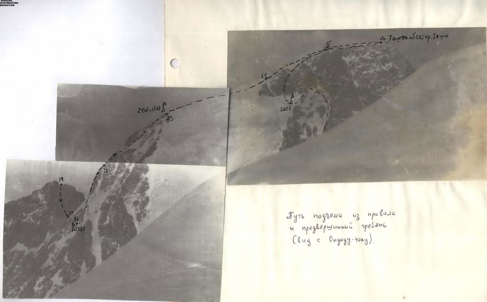
A gentle ascent to a rocky outcrop to the right, almost a rope's length, where a cairn is located (section 23). The first climber reaches the summit at 10:30 (PHOTO №13). We see tracks from a previous group. The mountain panorama is breathtaking. We leave a note, take photos. After an hour, the last member of the group arrives, and we begin descending via route 4A category difficulty toward Peak Ondouchoku.
First, we descend via snow along the edge of the rocks for 100 m (section 24), then rappel down the wall toward the ridge leading to Peak Ondouchoku for 5:X:40 m (section 25) to a snow-covered inclined plateau. One rope's length of ascent to a gendarme — movement via fixed ropes (section 26). Further, we descend via snow-covered rocks of moderate difficulty along the ridge to the saddle under Peak Ondouchoku (section 27); (PHOTO №14).
The descent to the saddle took 5 hours. From the saddle, we descend via a snow-ice slope for 2 hours down to the Tashtambe glacier. We traverse on a rope — the glacier is closed, and cracks are visible in places (section 28); (PHOTO №15).
At the bottom, we're greeted by the Vorobyev group. We drink tea and head to camp.
TABLE №1 ROUTE CHARACTERISTICS
| Date | SECTION | Length, m | Average Steepness, degrees | Relief Character | Difficulty | Condition | Weather Conditions | ROCK PITONS | ICE PITONS | BOULDER PITONS | ROCK PITONS REMOVED | ICE PITONS REMOVED | BOULDER PITONS REMOVED | Time of Departure and Stop, Walking Hours, Bivouac Conditions |
|---|---|---|---|---|---|---|---|---|---|---|---|---|---|---|
| 23.7. | 1 | 200 | 40 | Snow-ice slope | III | Snow-covered | CLEAR | 1 | 1 | - | - | - | - | departure 4:00 stop 18:00 X/Ч 14 semi-reclining normal |
| 2 | 280 | 50 | Rocks of buttress | III | Clear | Clear | 2 | 3 | - | 1 | - | - | ||
| 3 | 40 | 70 | Wall | V | Monolith | wind, snow grains | 4 | - | - | - | - | - | ||
| 4 | 40 | 30 | Ledge | IV | Monolith | -"-"-" | 2 | - | - | - | - | - | ||
| 24.7. | 5 | 80 | 85 | Rocks, ice | V | Monolith | CLEAR | 4 | 2 | - | 6 | 6 | 2 | departure 5:10 stop 18:30 X/Ч 13-20 on ridge good |
| 6 | 80 | 45 | Ice | V | Snow-covered | wind, snow | 2 | 4 | - | - | - | - | ||
| 7 | 80 | 70 | Rocky outcrops | V | Icy | -"-"-" | 5 | 1 | - | - | - | - | ||
| 8 | 40 | 45 | Destroyed rocks | III | Snow-covered | -"-"-" | - | - | - | - | - | - | ||
| 9 | 80 | 10 | Rocky ridge | III | Snow-covered | snowstorm | 2 | - | - | - | - | - | ||
| 25.7. | 9 | - | - | - | - | - | snowstorm | - | - | - | - | - | - | bivy |
| 26.7. | 9 | - | - | - | - | - | wind, fog | - | - | - | - | - | - | bivy, processing 5 hours |
| 27.7. | 10 | 120 | -8 | Rocky ridge | IV | Monolith | CLEAR | 3 | - | - | - | - | - | departure 4:30 stop 19:40 X/Ч 15 on ridge good |
| 11 | 80 | -45 | -"-"-" | IV | -"-"-" | CLEAR | 2 | - | - | - | - | - | ||
| 12 | 10 | -90 | Wall | IV | -"-"-" | CLEAR | 2 | - | - | - | - | - | ||
| 13 | 70 | 85 | Rocky wall | VI | normal | normal | 11 | 3 | - | 4 | 1 | 2 | ||
| 14 | 40 | 40 | Rocks | III | Snow-covered | normal | 1 | 1 | - | - | - | - | ||
| 28.7. | 15 | 80 | 35 | Rocks | III | Monolith | normal | 2 | - | - | - | - | - | departure 5:00 stop 15:00 X/Ч 9:00 processing 5 hours on ledge good |
| 16 | 80 | 70 | Rock-ice couloir | V | Snow-covered | snow, wind | 6 | 4 | - | 2 | 1 | - | ||
| 17 | 35 | 30 | Rocks | III | Snow-covered | fog, wind | 2 | - | - | - | - | - | ||
| 29.7. | 18 | - | - | - | - | - | snow, thunderstorm | - | - | - | - | - | - | bivy |
| 30.7. | 18 | 60 | 10 | Ice/lateral slope 40° | IV | Snow-covered | CLEAR | 2 | 3 | - | - | - | - | departure 5:00 stop at summit 10:30 on glacier 21:00 X/Ч 5:30 in base camp |
| 19 | 40 | 60 | Ice, rocks | V | Icy | CLEAR | 4 | 4 | - | - | - | - | ||
| 20 | 40 | 35 | Ice/lateral slope 40° | IV | Snow-covered | CLEAR | 2 | 4 | - | - | - | - | ||
| 21 | 60 | 60 | Rocks, ice | V | -"-"-" | CLEAR | 6 | 2 | - | - | - | - | ||
| 22 | 160 | 70 | Rocks | IV | Snow-covered | CLEAR | 10 | - | - | - | - | - | ||
| 23 | 40 | 25 | Snow slope | III | Loose | CLEAR | - | - | - | - | - | - | belay via ice axe | |
| DESCENT | ||||||||||||||
| TOTAL: | 74 | 31 | 12 | 9 | 4 | |||||||||
| 30.7. | 24 | 100 | - | Snow | III | Loose | CLEAR | - | - | - | - | - | - | |
| 25 | 200 | - | Rocks | V | Snow-covered | CLEAR | 10 | 4 | - | - | - | - | ||
| 26 | 40 | - | Ice | IV | Porous | CLEAR | - | 3 | - | - | - | - | ||
| 27 | 400 | - | Rocks | III | Snow-covered | CLEAR | 2 | - | - | - | - | - | belay via ice axe | |
| 28 | 1200 | - | Ice, snow | III | Closed glacier | CLEAR | - | 8 | - | - | - | - | ||
| TOTAL: | 12 | 15 | - | - | - |
Total pitons used: on ascent: — rock 90 — ice 40 on descent: — rock 12 — ice 15
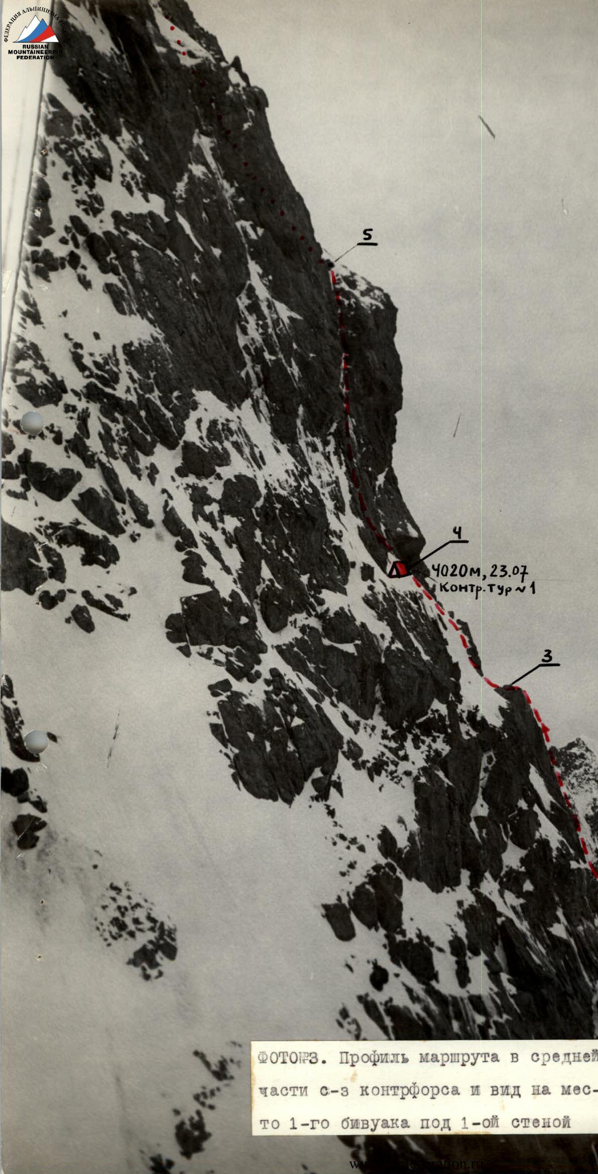
PHOTO №3. Profile of the route in the middle part of the NW buttress and view of the 1st bivouac site under the 1st wall.
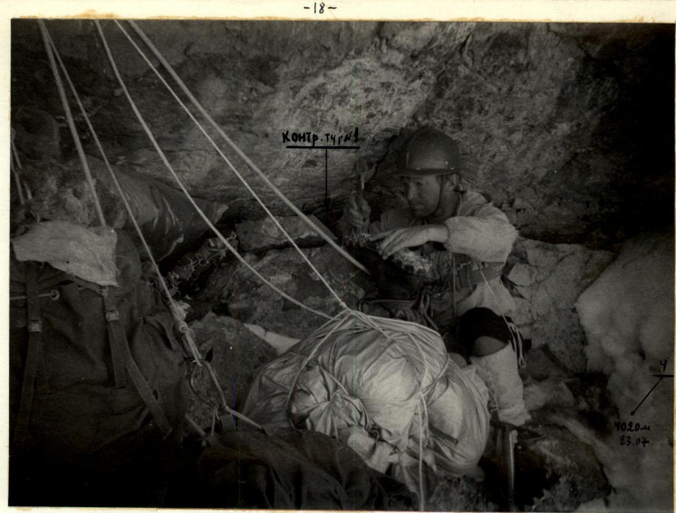
PHOTO №4. Bivouac under the 1st wall, location of the 1st control cairn.
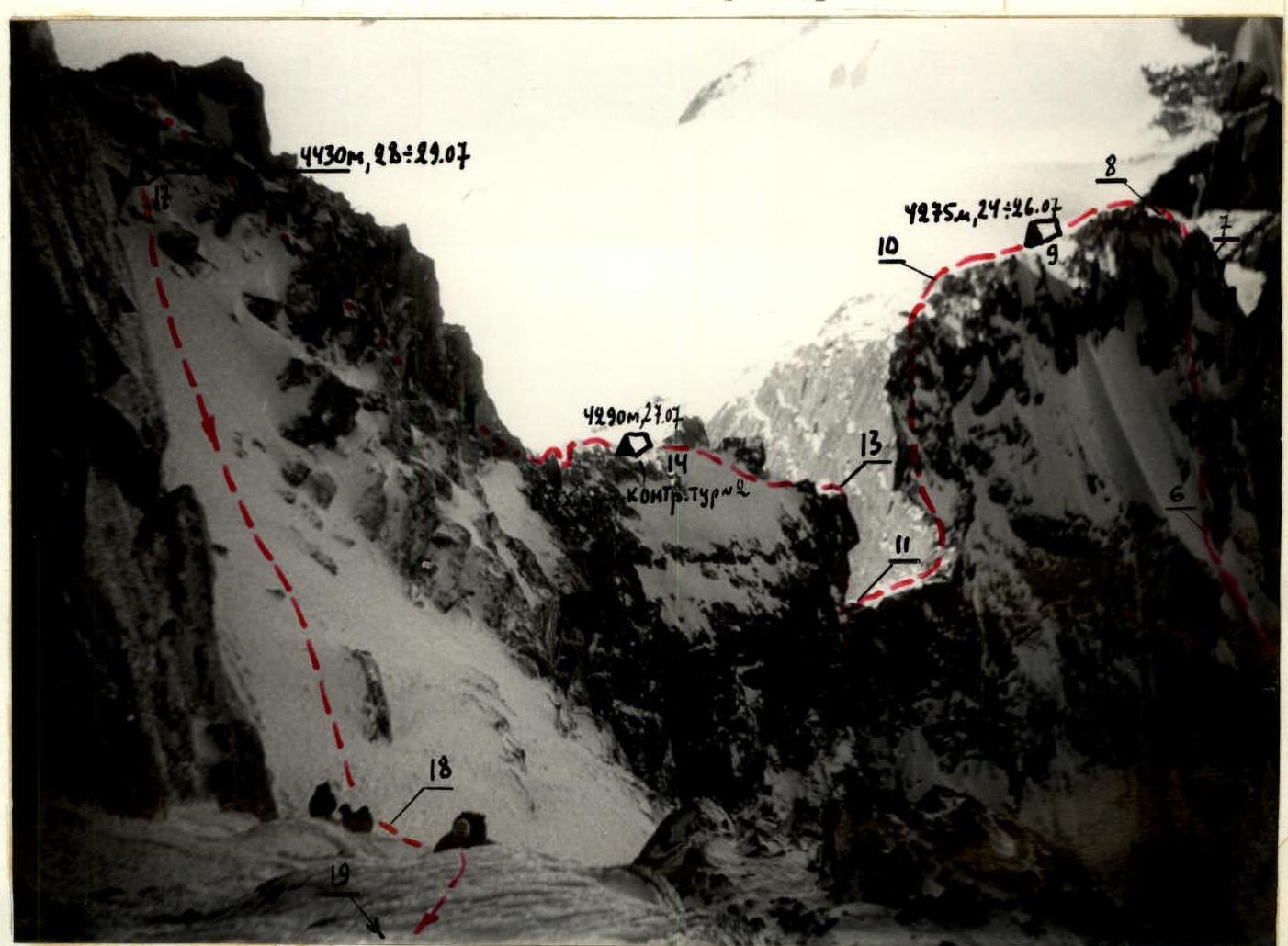 PHOTO №6. Passage of the lower part of the 1st 80-meter wall after the 1st bivouac (section 5).

PHOTO №8. Before the drop and the route out of it via the 2nd 80-meter wall to the Tashtambe peak massif (sections 10+13).
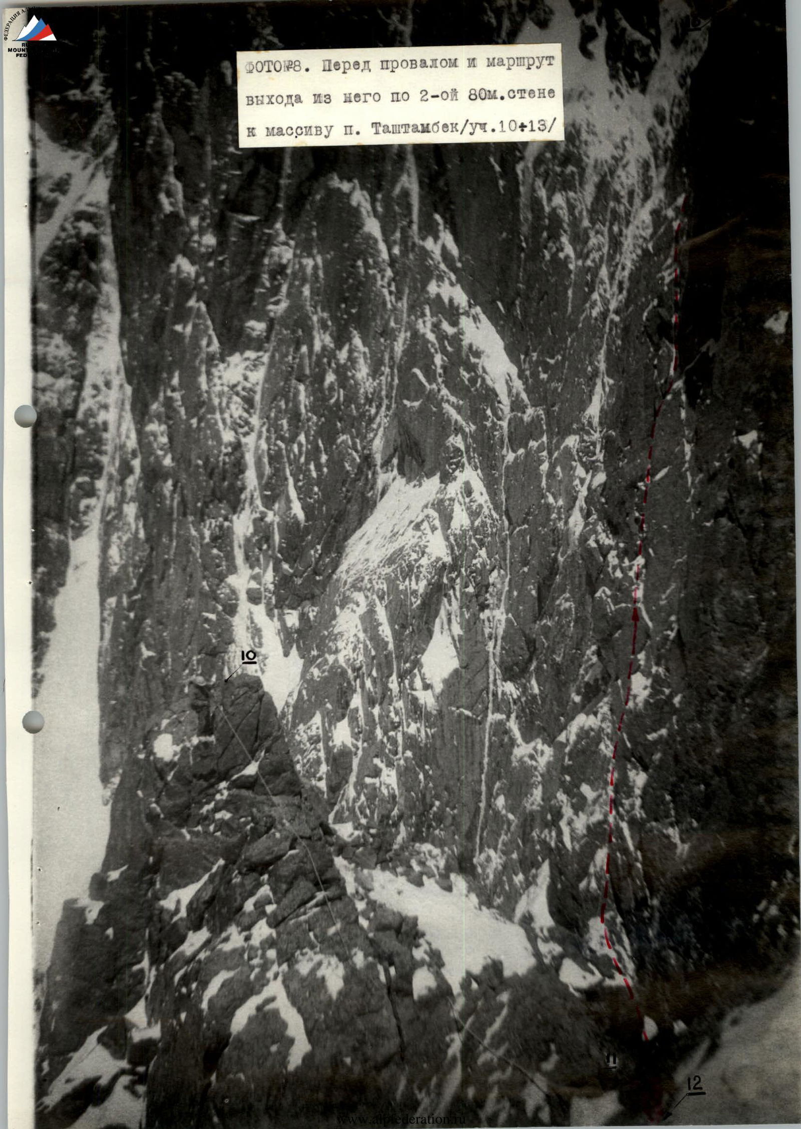
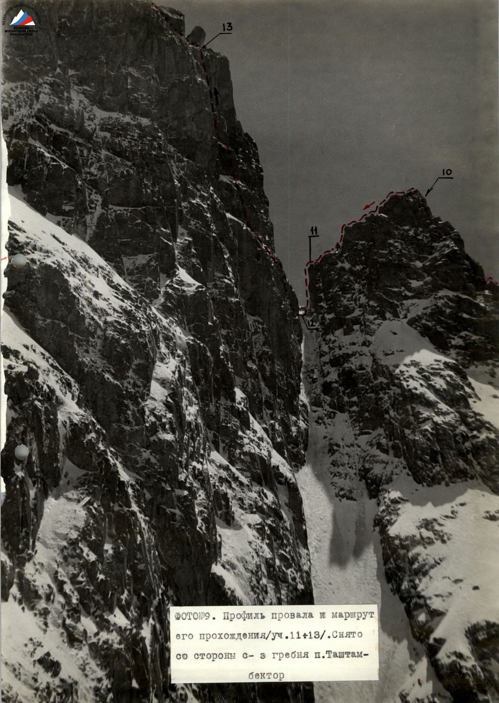
PHOTO №11. General view of the upper part of Peak Tashtambektor and the route after the drop. Profile of the pre-summit ridge.
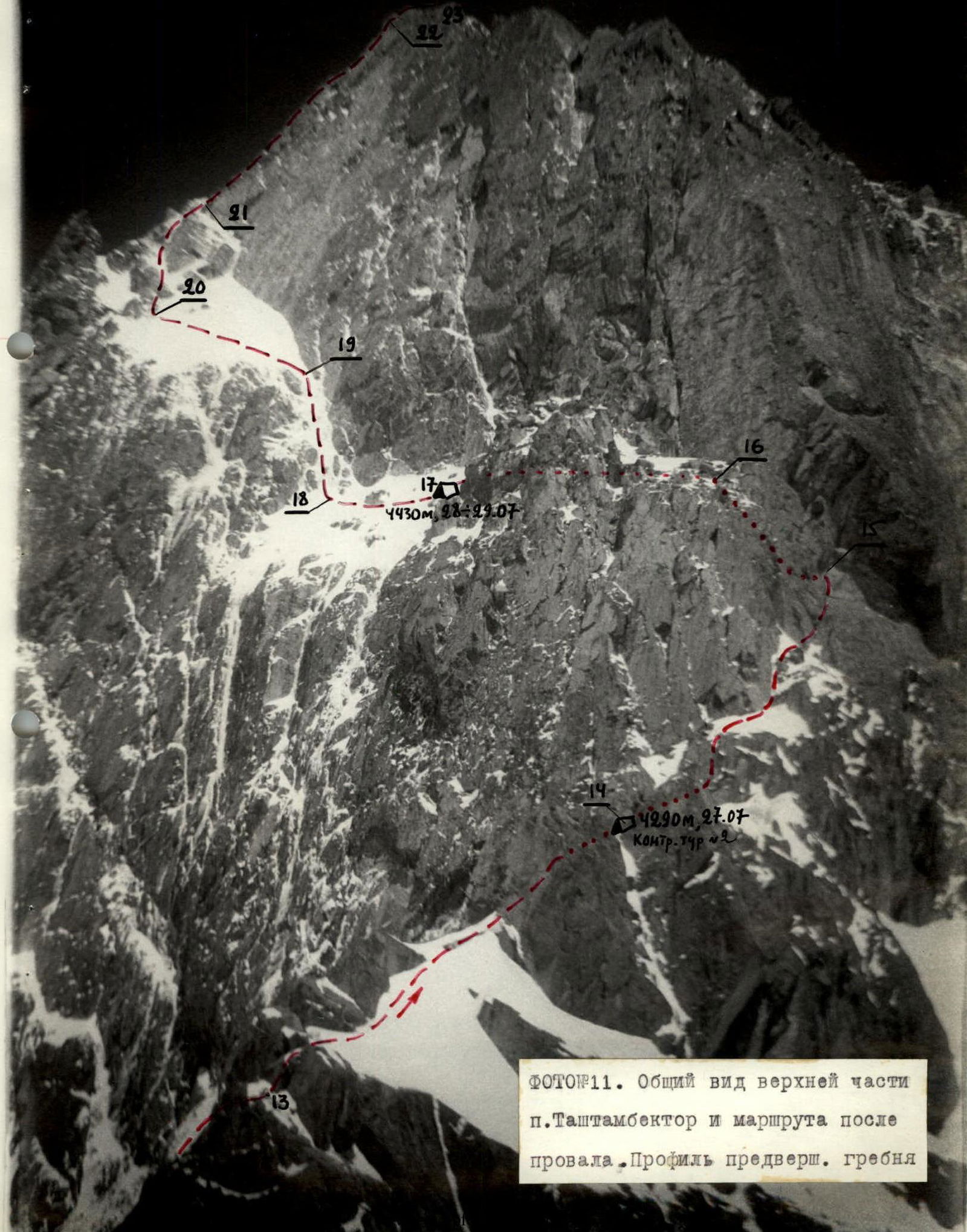
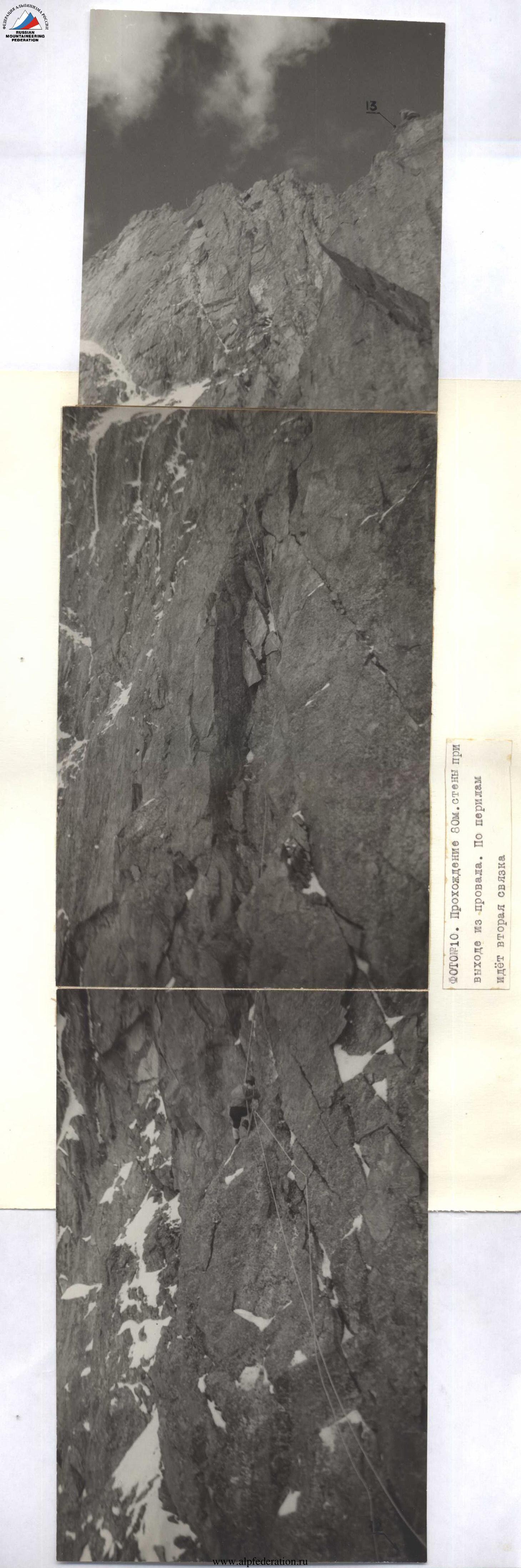
PHOTO №14. View of the upper part of Peak Tashtambe and the descent route. Taken from the upper reaches of the Tashtambe glacier from the side of the Tashtambe North pass.
