
Ascent Passport
- Ascent class — technical.
- Ascent area — Tian Shan, Terskey Ala-Too ridge.
- Summit — Slonënok peak, height — 4726 m, ascent route — Northwest counterfort.
- Proposed complexity category — 5B.
- Route characteristics: height difference — 1160 m,
average steepness — 72°, section lengths:
- 2nd difficulty category — 260 m.
- 3rd difficulty category — 17 m.
- 4th difficulty category — 111 m.
- 5th difficulty category — 1286 m.
- 6th difficulty category — 74 m.
- Pitons driven:
- for belaying:
- rock: 123
- ice: 55
- bolted: —
- for creating ITOS (Intermediate Technical Object System):
- rock: 23
- ice: 6
- bolted: —
- for belaying:
- Number of climbing hours — 33.5 h.
- Number of bivouacs, their characteristics — 2 bivouacs, both lying, on rocks.
- Surname, name, patronymic of the leader, participants, their sports qualification:
- Bochkov Dmitry Sergeevich — Candidate Master of Sports
- Streltsov Evgeny Aleksandrovich — Candidate Master of Sports
- Team coach Biryukov V.N., Candidate Master of Sports, senior instructor.
- Date of departure on the route — August 1, 1979
date of return from the route — August 3, 1979

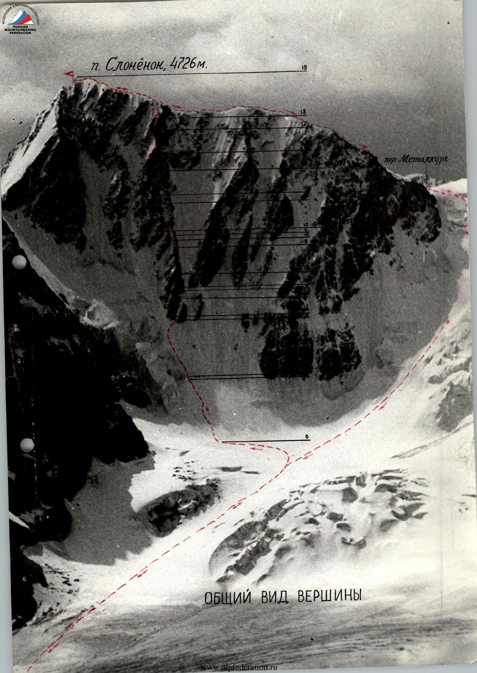
General View of the Summit
Table of Main Route Characteristics
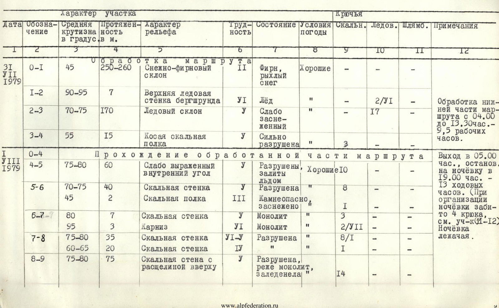
| Date | Designation | Average steepness in ° | Length in m. | Terrain characteristics | Difficulty category | Condition | Weather conditions | Rock pitons | Ice pitons | Bolted pitons | Notes |
|---|---|---|---|---|---|---|---|---|---|---|---|
| July 31, 1979 | R0–R1 | 45 | 250–260 | Snow-firn slope | 2 | Firn, loose snow | Good | — | — | — | Processing of the lower part of the route from 4:00 to 13:30 – 9.5 working hours. |
| R1–R2 | 90–95 | 7 | Upper bergschrund wall | 6 | Ice | " | — | 2/6 | — | ||
| R2–R3 | 70–75 | 170 | Ice slope | 5 | Weakly snow-covered | " | — | 17 | — | ||
| R3–R4 | 55 | 15 | Oblique rock shelf | 5 | Highly destroyed | " | 3 | — | — | ||
| August 1, 1979 | R0–R4 | Passage of the processed part of the route | Departure at 5:00, stop for the night at 19:00 – 13 climbing hours. (When organizing the bivouac, 4 pitons were driven, see section R11–R12) | ||||||||
| R4–R5 | 75–80 | 60 | Weakly expressed internal angle | 5 | Destroyed, iced | Good | 10 | — | — | ||
| R5–R6 | 70–75 | 40 | Rock wall | 5 | Destroyed | " | 8 | — | — | Bivouac lying. | |
| 45 | 2 | Rock shelf | 3 | Rocky, snow-covered | " | 1 | — | — | |||
| R6–R7 | 80 | 7 | Rock wall | 5 | Monolith | " | 3 | — | — | ||
| 95 | 3 | Cornice | 6 | Monolith | " | 2/7 | — | — | |||
| R7–R8 | 75–80 | 35 | Rock wall | 5–5 | Destroyed | " | 8/1 | — | — | ||
| 60–65 | 20 | Rock wall | 4 | " | " | 1 | — | — | |||
| R8–R9 | 75–80 | 75 | Rock wall with a crevice at the top | 5 | Destroyed, less monolithic, iced | " | 14 | — | — | ||
| August 1, 1979 | R8–R9 | 30 | 1 | Rock shelf | 4 | Snow-covered | Good | 1 | — | — | |
| R9–R10 | 60–65 | 30 | Rocks | 4 | Destroyed | " | 3 | — | — | ||
| R10–R11 | 75–80 | 20 | Rock wall | 5 | Destroyed | " | 5 | — | — | ||
| 80–85 | 20 | Internal angle with a crevice | 6 | Monolith, iced | " | 5/5 | — | — | |||
| R11–R12 | 45–50 | 15 | Implicit rock shoulder. Bivouac. | 3 | Destroyed | " | 4 | — | — | ||
| August 2, 1979 | R12–R13 | 75 | 100 | Rock wall | 5 | Destroyed, less monolithic | " | 12 | — | — | Departure at 7:30, stop for the night at 17:00. |
| 70 | 20 | Smoothed rocks | 5–6 | Monolith | " | 4/3 | — | — | Climbing hours — 9.5 h, bivouac lying (4 pitons driven for belaying). First ascenders' control tour. | ||
| R13–R14 | 80–85 | 20 | Wall with a slit | 5 | Monolith | " | 5 | — | — | ||
| 55–60 | 12 | Slab | 5 | Monolith | " | 5/2 | — | — | |||
| R14–R15 | 75 | 20 | Rock wall | 5 | Monolith | " | 5 | — | — | ||
| 90–95 | 8 | Internal angle | 6 | Monolith, iced | " | 2/4 | — | — | |||
| 75 | 65–70 | Rock wall, exit to a shelf | 5 | Destroyed | " | 12 | — | — | |||
| August 2, 1979 | R15–R16 | 60 | 10 | Internal angle | 4 | Monolith, snow-covered | " | 1 | — | — | Departure at 7:30, reaching the summit |
| 60–65 | 40 | Rock ridge, partly ice sections | 5 | Monolith, snow-covered, iced | " | 3 | 3 | — | at 12:30. Descent to "Metallurg" pass at 17:00, to the glacier at 18:00, to the assault camp at 18:30. Climbing hours — 11. | ||
| R16–R17 | 70 | 80 | Ice slope | 5 | Snow-covered | " | — | 10 | — | ||
| 45–50 | 30 | Ice ridge with cornices and a rock island | 4 | " | " | Rock outcrops 2 | 2 | — | |||
| August 3, 1979 | R17–R18 | 60 | 30 | Rock shelves | 5 | Snow-covered | Good | 3 | — | — | |
| 85–90 | 10–12 | Internal angle | 5–6 | " | " | 3/1 | — | — | |||
| R18–R19 | 60–65 | 100 | Ice ridge | 5 | " | " | — | 11 | — | ||
| 25–30 | 400 | Snow-ice corniced ridge with outcrops | 5 | Snow and firn cornices | " | — | 10 | — |
Brief Explanation of the Table
After traversing the Festivalnaya–Slonënok peaks (5B category), accomplished by the present pair (Bochkov D.S. – Streltsov E.A.) and a day of rest in the camp on the Karakol glacier moraine, the pair consisting of Bochkov D.S. – Streltsov E.A. departed at 4:00 on August 31, 1979, to process the ice slope in the lower part of the route. During processing, they traversed a snow-firn slope (about 240 m), then crossed the bergschrund with a difficult, overhanging wall using ice axes, ladders, and artificial footholds, and passed an ice slope about 170 m long (steepness 70–75°), with ice pitons driven for belaying, the upper end of which was fixed to the lower part of the counterfort, on the rocks.
By 13:00, the pair descended to the base of the slope via the hung belays (later — it was rockfall-prone), spending the night in the assault camp under the route, on the upper moraine. The pair of observers, Biryukov V.N. – Komissarov V.A., was also there.
On August 1, 1979, at 5:00, the pair departed from the assault camp, approached the route an hour later, put on crampons, traversed the snow-firn slope, the bergschrund, and, passing the ice slope, with an oblique traverse to the right in its upper part, reached the base of the rock counterfort.
The counterfort begins with a steep oblique shelf going to the right, composed of very highly destroyed rocks, with freely lying not quite large stones and boulders, slightly frozen at this time of day (10:00) (very warm weather, visibility is poor due to dust haze).
Further, we move into a vaguely expressed internal angle, weakly snow-covered, iced (section R4–R5), transitioning into a steep rock wall of highly destroyed rocks. Movement is very cautious, rockfall-prone.
Exit to a short rock shelf, snow-covered, with freely lying stones on it. Along this shelf — exit to the left under a monolithic wall with an overhang in its lower part. This section (R6–R7) is passed using artificial footholds (ladders). Further, the wall, gradually becoming less steep, becomes more destroyed and less difficult.
Further, there is a wall consisting of highly destroyed rocks, 70–80 m long, with an oblique crevice at the top (section R8–R9), after overcoming which — exit to a snow-covered narrow shelf.
Further, along destroyed rocks of medium difficulty, we exit under a wall about 20 m high, after overcoming which we face a steep internal angle, iced (overcome using ladders).
Exit to a rock shoulder of the counterfort, consisting of gently sloping destroyed rocks. Here — a place for a bivouac. We stopped for the night at 19:00 (13 climbing hours).
On August 2, 1979, departure at 7:30. The weather is very warm, good.
From the bivouac, directly upwards, begin difficult destroyed rocks, partly more monolithic, smoothed in the upper part, passed with artificial footholds (ladders). Further — exit to the right via a slit onto a slab with very rare holds. When passing the slab, an artificial foothold is used (pit ladder). Along the slab — exit under a wall with a weakly expressed overhanging internal angle. Climbing is very difficult, with the use of ladders. Further, the wall — difficult, highly destroyed rocks. Above the wall — an inclined shelf. Here — a place for a bivouac and a control tour of the first ascenders. After expanding it and laying out stones — a lying bivouac. (Above — an ice section, the snow on it has thawed, and crampons do not hold). We stopped for the night at 17:00. Climbing hours — 9 h 30 min.
On August 3, 1979, departure at 7:30. First, along an internal angle (10 m) — exit to the counterfort and cautious movement along the rock ridge of the counterfort — along the edge of ice and rocks, sometimes on ice in crampons (30–40 m). Above — an ice slope — about 80 m (up to 70°), exit to a section of an ice-snow corniced ridge with a small rock outcrop, exit under the upper rock bastion. In the lower part of the bastion — passage of steep, rockfall-prone shelves with freely lying stones (about 30 m); further, about 12 m upwards along an internal angle, slightly overhanging in the upper part (passed to the left along a wide crevice).
Above — a steep ice counterfort (90–100 m), up to 60–65°, along which, in crampons, with belaying through ice pitons, partly with step-cutting, we exit to the main ridge of the summit. The ridge is sharp, icy, with heavy snow-firn, quite strong cornices — very cautious movement with piton belaying. Somewhere, rock "islands" are encountered in the ridge.
Reached the summit at 12:30. The weather is very good, warm, visibility in the distance is poor due to dust haze.
From the summit, descent along the ridge in the opposite direction — to the "Metallurg" pass (by 17:00), from the pass — descent, bypassing two ice drops — downwards with a leftward sweep (with belaying through ice pitons and ice axe — 4 ropes), further movement with alternate belaying (about 150 m), then — simultaneous movement to the glacier (by 18:00). At 18:30, the pair reached the assault camp, where they observed the pair Biryukov V.N. – Komissarov V.A., who had departed for the third passage of our route.
Description of the Ascent Route
From the bivouacs under the route on the Aiu-Ter river under the "ram's foreheads" the entire wall is clearly visible through binoculars and was thoroughly studied visually in accordance with the description we received from the first ascenders.
Having crossed the river, we approach the start of the route along medium and small scree — about 1 hour. The wall is bounded on the left and right by hanging glaciers, from which streams flow, bounding the wall below with waterfalls.
The first ascenders ascended via a couloir towards the left waterfall, bypassing the overhanging wall in the lower part of the route on the left. According to our observations, the couloir is exposed to rockfall, and the traversed route actually crosses the wall from left to right. Therefore, we chose a different start to the route. Having approached the couloir under the left waterfall, we immediately exited onto the wall to the left of the waterfall, bypassing the overhang on the right. This makes the route more direct, logical, and safer. Under the wall, we put on crampons and linked up.
R0–R1. Along grey crumbling rocks to a shelf. Climbing is not difficult. 50 m / 60°, 2 pitons. R1–R2. Upwards along rocks of above-average difficulty and difficult along the wall. The waterfall remains to the right, about forty meters away. Exit to a shelf. Destroyed rocks. 60 m / 75°, 5 pitons, 2 chocks. R2–R3. Along the shelf to the left for 15 m under an internal angle and upwards along it for 15 m. Exit to a large scree shelf. Climbing is of average difficulty. 30 m / 65°, 2 pitons, 1 chock. R3–R4. Along the shelf for 40 m upwards under an overhanging wall. The beginning of the first key section. 40 m / 45°. R4–R5. Upwards under an overhanging internal oblique angle, which is traversed from left to right. Rocks are wet, covered in lichen, slippery. Climbing is very difficult, ITOS (artificial technical object system). Intoxicating smell of mosses covering the internal angle and masking cracks. 10 m / 85°, 6 pitons, 2 chocks. R5–R6. Then to the right and upwards along shelves and walls under an overhang, climbing of average difficulty. 50 m / 65°, 2 pitons, 1 chock. R6–R7. Along the wall to the left and upwards, difficult climbing along wet rocks to the left of the overhanging tower with black streaks. 40 m / 75°, 5 pitons, 2 chocks. Exit to a small shelf. R7–R8. Along the wall first to the right, then upwards, very difficult climbing, ITOS. 40 m / 85°, 6 pitons, 1 chock. R8–R9. Along a wet internal angle to the left for 10 m and then straight upwards along the wall for 40 m. The weather worsened sharply: wind, wet snow. Rocks became wet, then iced. 50 m / 85°, 10 pitons, 3 chocks. To the right, exit to a shelf. Climbing of extreme difficulty, ITOS. R9–R10. Along scree shelves and rocks of average difficulty, belaying for outcrops, to the right and upwards over an overhanging brown summit bastion onto a scree shelf. Here, on a piton, is a tin can — a control tour. Bivouac possible. 100 m / 45°. R10–R11. From the shelf to the right along a chimney onto a pronounced counterfort to the right of the summit bastion and along the counterfort straight upwards under an overhanging brown wall. Rocks are destroyed, climbing is above average difficulty. 40 m / 75°, 3 pitons, 1 chock. R11–R12. The wall is traversed along an oblique overhanging internal angle from left to right. Very difficult climbing, ITOS. 20 m / 100°, 5 pitons, 2 chocks. R12–R13. Straight upwards along the wall to exit onto the "edge" of the wall. Difficult climbing. The fragmentation of the rocks allows the use of chocks. Live rocks! 100 m / 75°, 7 pitons, 10 chocks. R13–R14. Along the edge of the wall to the left under the summit wall of the triangle, using chimneys and internal angles. Here, a semi-lying bivouac is possible on a scree shelf. 90 m / 75°, 9 chocks, 2 pitons. R14–R15. The summit tower is traversed along brown cracks to the left, very difficult climbing, ITOS. 80 m / 85°, 6 pitons, 5 chocks.
Exit to a sharp ridge, control tour. Bivouac possible. R15–R16. Along the ridge for 150 m, then to the right and down, bypassing gendarmes along scree and snow shelves for 250 m. Exit to a saddle. 400 m.
Then to the right along the ridge for 400 m to the summit of Mendeleevets peak along destroyed rocks and a snow slope. On sections R13–R16 — another deterioration in the weather, heavy snowfall; again, climbing became an unpleasant occupation.
Due to the onset of darkness and an approaching thunderstorm, we bivouacked under the summit ridge. In the morning, we ascended to the summit and descended via route 2A category, organizing two sports descents on ice using ice screws.
Table of Main Characteristics of the Ascent Route
| Date | №№ | Avg. steepness | Length, m. | Terrain characteristics | Difficulty category | Condition | Weather | Rock pitons | Chocks | ITOS |
|---|---|---|---|---|---|---|---|---|---|---|
| August 17 | R0–R1 | 60 | 50 | wall, shelves | 3 | destroyed | good | 2 | — | 1 |
| R1–R2 | 75 | 60 | wall | 5 | destroyed | " | 5 | — | 2 | |
| R2–R3 | 65 | 30 | shelf, chimney | 4 | monolith | " | 2 | — | 1 | |
| R3–R4 | 40 | 40 | shelf | 2 | destroyed | " | — | — | — | |
| R4–R5 | 85 | 10 | internal angle | 6 | monolith | " | 6 | 2 | 3 | |
| R5–R6 | 65 | 50 | shelves | 4 | monolith | satisfactory | 2 | — | 1 | |
| R6–R7 | 75 | 40 | wall | 5 | wet rocks | " | 5 | — | 2 | |
| R7–R8 | 85 | 40 | wall, internal angle | 6 | wet rocks | bad, snow | 6 | — | 3 | |
| R8–R9 | 85 | 50 | wall | 6 | iced rocks | bad, snow | 10 | 3 | 3 | |
| R9–R10 | 45 | 100 | shelves | 2 | destroyed | blizzard | — | — | control tour | |
| R10–R11 | 75 | 40 | chimney | 4 | fragmented | satisfactory | 3 | — | 1 | |
| R11–R12 | 100 | 20 | overhanging internal angle | 6 | monolith, wet rocks | " | 5 | — | 3 | |
| R12–R13 | 75 | 100 | wall | 5 | monolith | satisfactory | 7 | 10 | — | |
| R13–R14 | 75 | 90 | chimneys, angles | 5 | monolith, wet rocks | wet, snow | 2 | 9 | — | |
| R14–R15 | 85 | 80 | tower, walls | 6 | wet rocks | blizzard | 6 | 5 | 2 | |
| R15–R16 | 35 | 400 | ridge | 3 | destroyed | satisfactory | — | — | — | |
| R16–R17 | 35 | 300 | ridge | 2 | destroyed | satisfactory | — | — | — | |
| Bivouac semi-lying. Departure at 5:30, stop at 21:30. Climbing hours — 15.5. | ||||||||||
| R16–R17 | 35 | 100 | ridge | 2 | destroyed | good | — | — | — | |
| Climbing hours — 5.5. Summit Mendeleevets, descent to the Aiu-Ter gorge. | ||||||||||
 |
Comments
Sign in to leave a comment