
ASCENT DOCUMENT
- Ascent classification — technical, route — combined.
- Ascent area, ridge — Central Tien-Shan, Terskey Ala-Too ridge.
- Peak, its height, ascent route — p. Slonenok, 4720 m, route through the center of the north-west wall.
- Estimated category of difficulty — 5A.
- Route characteristics: height difference — 900 m, length of sections with 5th cat. diff. — 260 m, average steepness — 55°
- Pitons hammered in: rock: for belay — 57 for creating TAE — 1 ice — 59 chocks — 2
- Number of climbing hours — 16
- Number of bivouacs — no bivouacs.
- Leader — Tryanin B.V. — 1st sports category
Team members:
- Kirilin I.G. — 2nd sports category
- Fedoseev V.B. — 2nd sports category
- Trokhov A.M. — 2nd sports category
- Team coach — Kuvatov G.D. — Candidate Master of Sports, instructor 2nd category.
- Date of departure on the route and return to bivouacs — July 20, 1984.
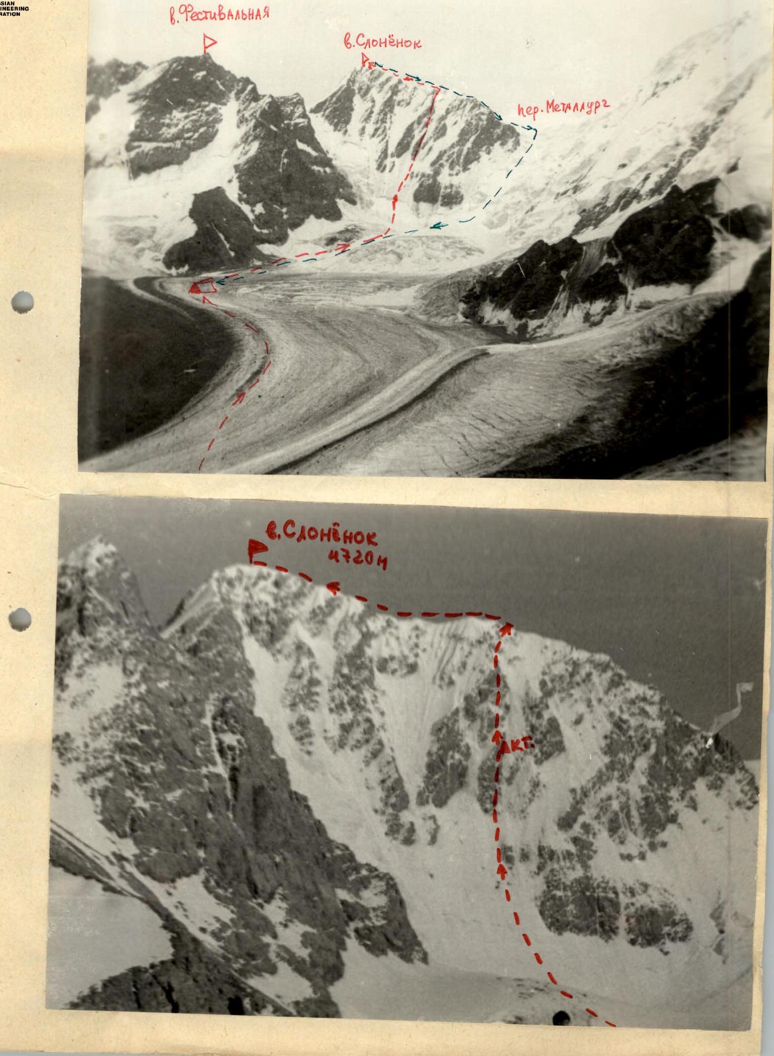
Description of the approach to the route
Departure from the base camp of a/l "Ala-Too". Movement upwards to the Karakol glacier along the left (orographic) side of the Okon-Tor gorge — 4 hours. Further along the left (orographic) lateral moraine — exit to the Karakol glacier and along the gentle middle part of the glacier — movement to the cirque of the peaks Festivalnaya and Slonenok — 2 hours 30 minutes. Bivouac on the median moraine. There are many ready-made sites.
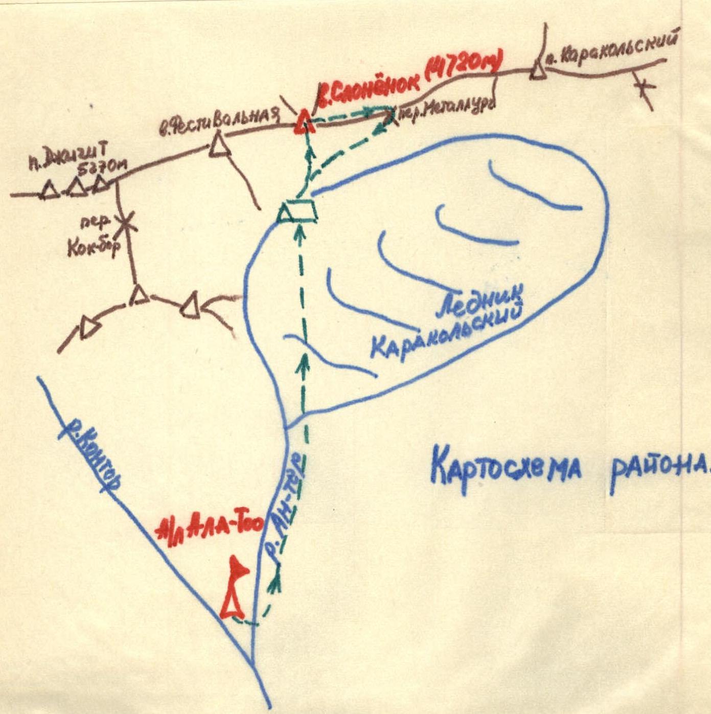
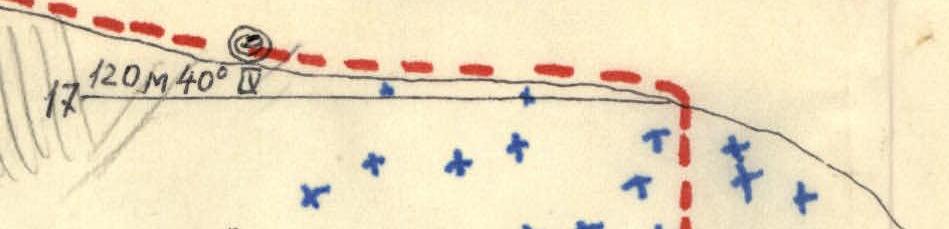
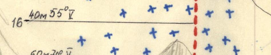
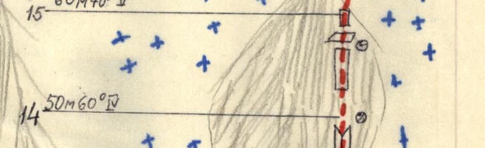
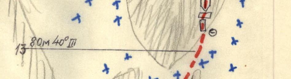
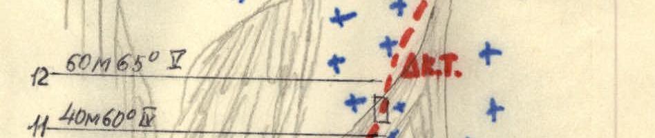
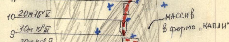
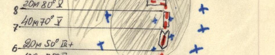
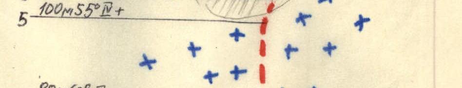
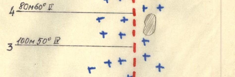
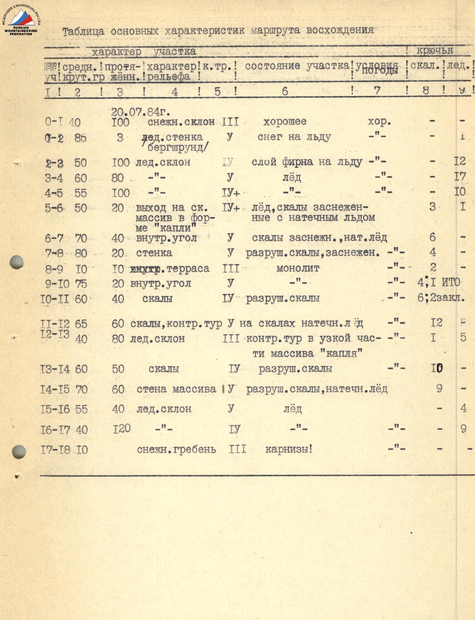
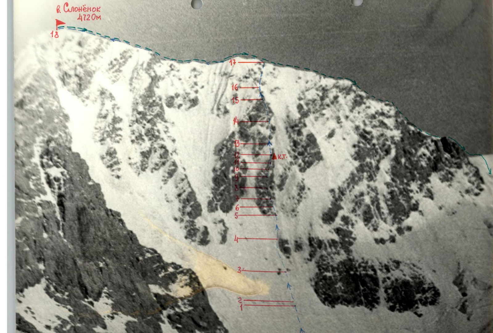
Table of main characteristics of the ascent route
Date: July 20, 1984
| Section | Avg. steepness | Length | Terrain characteristics | Cat. diff. | Section condition | Weather conditions | Rock pitons | Ice pitons |
|---|---|---|---|---|---|---|---|---|
| R0–R1 | 40° | 100 m | snow slope | 3 | good | good | – | – |
| R0–R2 | 85° | 3 m | ice wall of the bergschrund | 5 | snow on ice | – | – | 1 |
| R2–R3 | 50° | 100 m | ice slope | 4 | layer of firn on ice | – | – | 12 |
| R3–R4 | 60° | 80 m | – | 5 | ice | – | – | 17 |
| R4–R5 | 55° | 100 m | – | 4 | – | – | – | 10 |
| R5–R6 | 50° | 20 m | exit to the rock massif in the form of a "drop" | 4 | ice, rocks snow-covered with flow ice | – | 3 | 1 |
| R6–R7 | 70° | 40 m | inner corner | 5 | rocks snow-covered, flow ice | – | 6 | – |
| R7–R8 | 80° | 20 m | wall | 5 | destroyed rocks, snow-covered | – | 4 | – |
| R8–R9 | 10° | 10 m | inner terrace | 3 | monolith | – | 2 | – |
| R9–R10 | 75° | 20 m | inner corner | 5 | – | – | 4 (1 TAE) | – |
| R10–R11 | 60° | 40 m | rocks | 4 | destroyed rocks | – | 6 (2 chocks) | – |
| R11–R12 | 65° | 60 m | rocks, control point on rocks with flow ice | 5 | – | – | 12 | – |
| R12–R13 | 40° | 80 m | ice slope | 3 | control point in the narrow part of the "drop" massif | – | 1 | 5 |
| R13–R14 | 60° | 50 m | rocks | 4 | destroyed rocks | – | 10 | – |
| R14–R15 | 70° | 60 m | wall of the massif | 5 | destroyed rocks, flow ice | – | 9 | – |
| R15–R16 | 55° | 40 m | ice slope | 5 | ice | – | – | 4 |
| R16–R17 | 40° | 120 m | – | 4 | – | – | – | 9 |
| R17–R18 | 10° | – | snow ridge | 3 | cornices! | – | – | – |
Brief explanation of the table
The route begins from a snow cushion in the upper part of the cirque of the p. Slonenok massif (see photo). Section R1–R2 is a snow slope, along which you can exit to a horizontal section of the bergschrund line at the bottom of the p. Slonenok massif. The bergschrund wall (R2–R3) is overcome head-on using an ice axe and ice hammer. The ice slope at the bottom of the route (R3–R4) is heavily snow-covered (firn). Movement straight up under the left rock island (see photo). Further, the ice slope becomes steeper, the layer of firn on the ice disappears, and the rock island is bypassed on the left along the ice using ice hammers and ice screws (R4–R5). Section R5–R6 is an inclined traverse of the ice slope with an exit to snow-covered rocks (there is flow ice) of the massif in the form of a "drop", here there is a small site where you can remove crampons. The inner corner (R6–R7) leads to a small shelf where you can accommodate two people. The wall (R7–R8) is overcome head-on. Then follows a traverse to the left along a small rock terrace (R8–R9). The inner corner is passed using TAE and ladders, with a small traverse to the right. Along rocks of medium difficulty — exit to the left highest side of the massif (R0–R11). Further movement straight up along monolithic rocks (R11–R12). The control point is located in the upper, narrow part of this massif on a small rock ledge. The narrow part of the massif is bypassed on the left along the ice, after which the movement along the ice is straight up to the beginning of the next rock massif (R12–R13). Along rocks of medium difficulty and above medium — upwards, sticking to the right side of the massif (R13–R14). Near the border of ice and rocks, the ascent (R14–R15) along the wall of the massif (be careful, loose rocks!) to exit to a steep ice slope leading to the ridge of p. Slonenok (R15–R16). The last section to the exit to the ridge is passed simultaneously with belay using ice screws (R16–R17). The exit to the summit is along the snow ridge of the massif (be careful, cornices!). The time of movement along the ridge to the summit is 1 hour.
Description of the descent from the summit
Descent from the summit Slonenok along the sharp corniced ridge to the Metallurg pass. From the pass, descent down — two rappels of 40 m. The further path crosses the bergschrund. When overcoming it, reliable belay is necessary. Then down along a steep snow slope (attention, crevasses!). Be wary of rockfall from the slope of p. Slonenok, stick to the slopes of p. Karakolsky. Descent to the glacier (closed crevasses!), then along the talus to the bivouacs.
Comments
Sign in to leave a comment