Ascent Passport
- Ascent class — technical
- Ascent area — Tian Shan, Terskey Ala-Too ridge, Arashan-Tashtektor gorge
- Peak — Palatka, 4800 m, via the counterfort of the North face
- Complexity category — approximately 6B, first ascent, combined route
- Route length — 1320 m, wall section length — 1020 m, of which 5–6th cat. dif. — 800 m, 6th cat. dif. — 240 m, height difference on the wall section — 870 m, total height difference — 1040 m, average steepness of the wall section — 64°
- Number of pitons and placements used:
- Rock pitons: 71
- Placements: 24
- Ice screws: 66
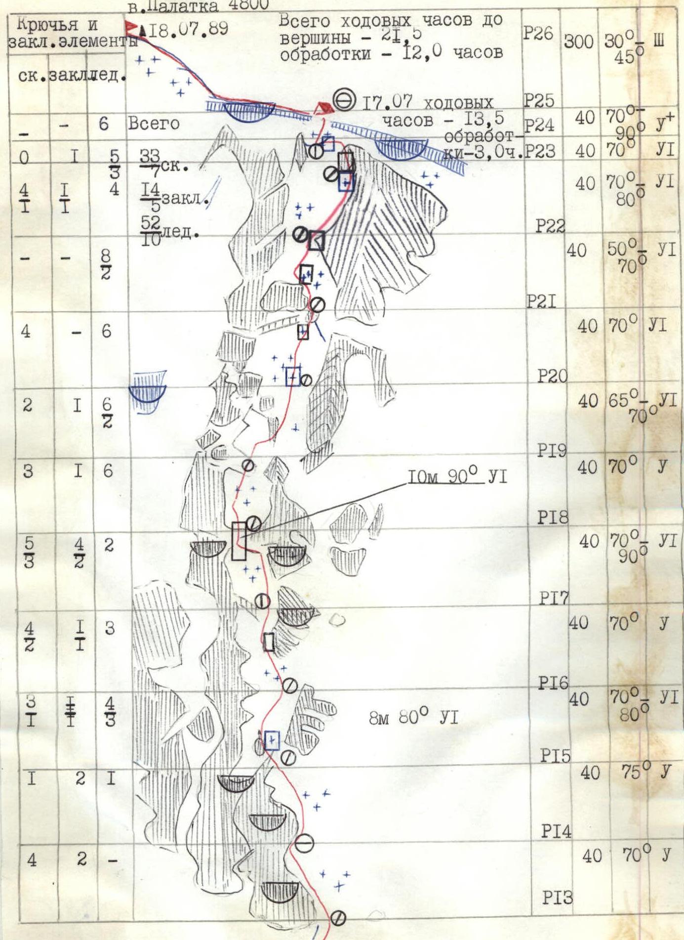
- Team's climbing hours: to the summit — 21.5 hours; route processing — 12.0 hours. Ascent days — 3.
- Overnights — 2, lying down, on snow platforms.
- Team captain — Chmutov Alexander Mikhailovich, CMS, Leningrad. Participants:
- Vysotsky Vladimir Mikhailovich, CMS, Leningrad
- Klimov Alexander Petrovich, CMS, Gorky
- Lopatko Alexey Dmitrievich, CMS, Leningrad
- Coach — Trubnikov Vladimir Ivanovich, MS, Nikolaev.
- Approach to the route — July 16, 1989. Summit — July 18, 1989. Return — July 18, 1989.
- Team of AUSB "Ala-Too", performance at the II championship of AUSB and KSP VS VDFSO trade unions
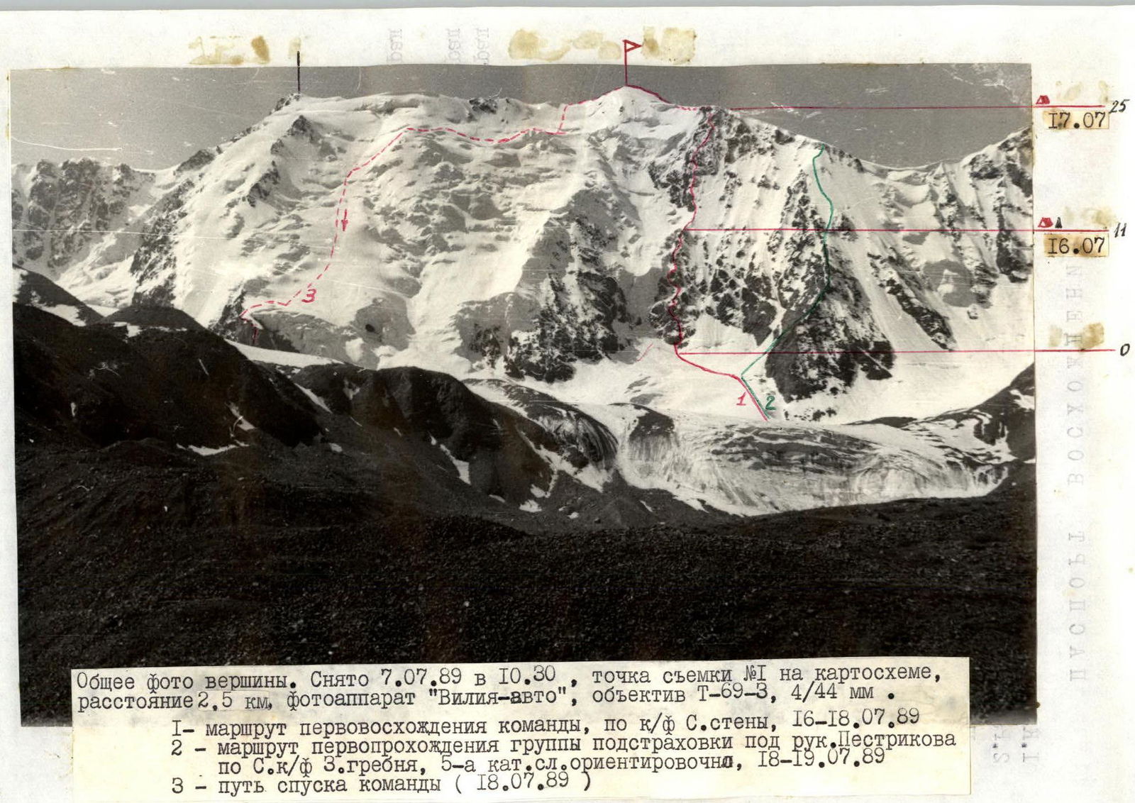
General photo of the summit. Taken on July 7, 1989, at 10:30, shooting point #1 on the map, distance 2.5 km, camera "Vilia-auto", lens T-69-3, 4/44 mm. 1 — route of the team's first ascent, via the counterfort of the North face, July 16–18, 1989. 2 — route of the backup group's first passage under Pestrikov's leadership via the counterfort of the West ridge, approximately 5A cat. dif., July 18–19, 1989. 3 — team's descent route (July 18, 1989).

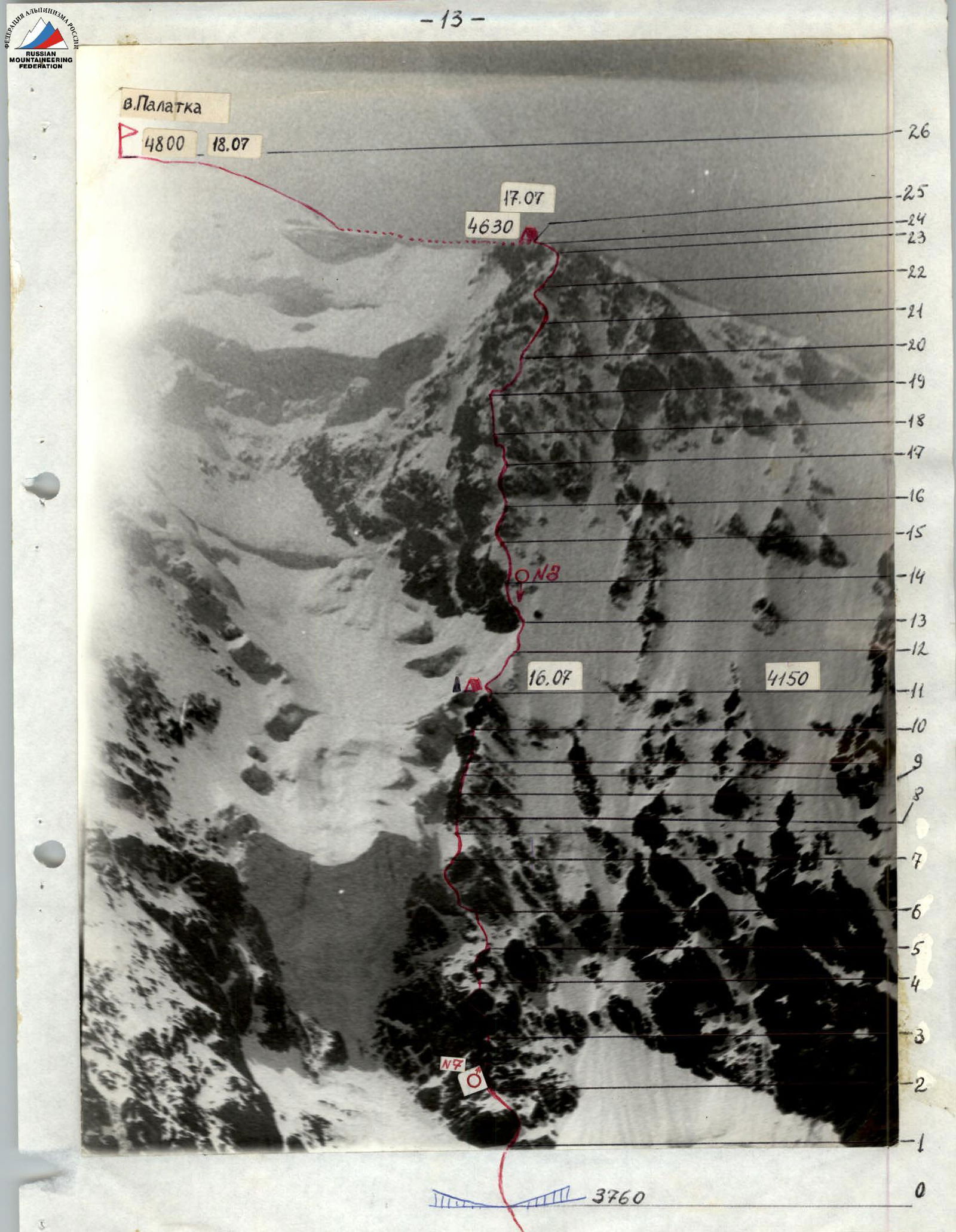
Photo of the route profile on the right. Taken on July 7, 1989, at 13:00. Shooting point #2, distance 1.5 km, "Vilia-auto". — photo shooting points

Map of the Arashan gorges area
Brief Overview of the Ascent Area
The peak Palatka is located in the main ridge of Terskey Ala-Too, in the upper reaches of the Arashan gorge, more precisely, in the upper reaches of the right tributary of the Arashan river — Tashtektor. The Arashan gorge is located east of the neighboring Karakol gorge. It is very picturesque, often visited by tourists, and is home to the folk resort Altyn-Arashan, where there are hot springs. In terms of mountaineering, the gorge is practically undeveloped, although there are a number of interesting objects here. These include the Aksui wall, the North face of Palatka, and the peak Soviet Russia.
The Arashan gorge is relatively inaccessible due to the poor condition of the road from the settlement Teploklyuchenka to the resort, which is located in a canyon — it takes 2–3 hours to cover the 17 km by car.
One can reach Arashan:
- directly from the Karakol gorge through the Ala-Kel pass, which takes one day — this is a very popular tourist route.
From the Altyn-Arashan resort, where the snowy North face of Palatka is clearly visible, a smooth trail along the right orographic bank of Arashan leads through 7 km to the confluence of the Tashtektor and Takyr-Tor rivers (Ekichat glade). From here, the Aksui wall is visible in the Takyr-Tor gorge.
Further, the trail continues along the right bank of Tashtektor and after 6–7 km leads to a wide final glade before the moraine ramparts. Here are the last groups of spruce trees, and the remains of a rain gauge are found, and the North face of Palatka becomes visible again. Height — 2900 m.
The Tashtektor glade breaks into several branches — sources that can be crossed by stones closer to the terminal moraine ramparts of the Tashtektor glacier. The trail, which goes under the tongue of the Palatka glacier, rises to the right of a short, powerful water stream along a grassy slope and then passes along green hills and leads to floodplain platforms under the tongue of the glacier. There are many convenient bivouac sites here. From the resort — 5–6 hours of walking.
One can ascend to the Palatka glacier along its left (orographically) lateral moraines directly under the snowy ascent, which leads to the beginning of the route. Here, on a small surface moraine, there are places for a bivouac.
The team's ascent route lies along a steep rocky counterfort, divided by a snowy ridge into two parts, and located to the right of the large ice falls of the North face. When approaching the start of the route, one should beware of:
- ice avalanches from the left;
- avalanches;
- falling cornices from the West ridge of the summit to the right.
The approach from the last green glades under the glacier to the start of the route takes 1.5–2 hours.
Team's Tactical Actions
Due to the fact that there was no sufficiently safe place for an overnight stay on the lower part of the counterfort, it was decided to process the beginning of the route in such a way that the next day it would be possible to reach the snowy ridge dividing the counterfort into two parts.
On July 15, the Klimov A. — Lopatkin A. rope processed 6 ropes (sections R0–R6), which allowed the team to reach the shoulder of the counterfort by July 16 at 15:30 and organize a safe overnight stay there. Then, another 2.5 ropes of the snowy ridge and 1 rope along the edge of the steep rocky wall of the upper part of the counterfort were processed.
Movement along the route was carried out in such a way that all team members were always on two ropes — climbing along the fixed ropes with insurance on another rope. In conditions of a steep and stone-dangerous route, especially on sections R1–R5, R6–R11, and R14–R19, this measure significantly increased the safety of passage.
The first climber (on sections R6–R11, R19–R24 — Chmutov A., on sections R14–R19 and R24–R25 — Vysotsky V.) went on a double rope, almost always in crampons (except for sections R3–R5, R8–R11, and the last 10 m on section R17–R18). Ice screws and hook-protected traverses were constantly used, especially on the upper part of the counterfort.
The exit to the West ridge was successful without cutting through the cornice — when traversing under the cornice to the left for 25–30 m, they reached a place where the cornice turned into a snowy-ice wall 2–3 m high.
A great danger on the route, especially on its lower part, was posed by ice avalanches and avalanches falling from the ice falls to the left of the counterfort. Therefore, the route lay mainly to the right of the main ridge of the counterfort (in its upper part — along the right ridge of the two parallel ones that make up the counterfort). The exit to the ridge of the counterfort on section R5–R6, where the snowy shoulder is overlapped by avalanches, is safe only in the morning and requires attention.
The tactical plan (see Appendix) was carried out by the team without significant deviations. An overnight stay on the West ridge, rather than before exiting onto it, was considered as a backup option.
When descending from the summit along the ridge towards the East summit, the group encountered the fact that the ridge was very dangerous due to long cornices in poor condition. Therefore, it was decided, taking into account that the snow was still frozen and there was no sun due to haze, to descend from the first large ridge junction onto the ice falls of the North face and descend along them to the ridge of the left edge of the North face. When crossing avalanche-prone slopes-gullies, they took into account that in most places the snow had already fallen off over the previous 4 days of good weather.
This descent option requires:
- good snow conditions
- caution when crossing avalanche-prone areas
- consideration of weather conditions
Under normal conditions, this route may be avalanche-prone.
Overall, the team was able to correctly assess the nature of the technical difficulties of the route, which made it possible to draw up a feasible plan for its passage.
The new route on the North face of Palatka passed by the team:
- is technically saturated,
- logical,
- has a pronounced combined character.
Communication with the backup group was carried out on "Kaktus" radios and was stable and regular. Communication with AUSB "Ala-Too" was carried out through "Karat" located with the backup group and was also regular.
| Section # | Rock pitons | Placements | Ice screws | Length, m | Steepness, ° | Cat. dif. |
|---|---|---|---|---|---|---|
| R0 | 2 | 0 | 2 | |||
| R1 | 3 | 0 | 1 | 40 | 50 | 4 |
| R2 | 0 | 0 | 0 | 40 | 70 | 6 |
| R3 | 3 | 1 | 0 | 40 | 70 | 6 |
| R4 | 5 | 0 | 0 | 40 | 60 | 5 |
| R5 | 6 | 0 | 0 | 40 | 55 | 4 |
| R6 | 2 | 2 | 1 | 40 | 70 | 6+ |
| R7 | 3 | 1 | 5 | 40 | 90 | 6 |
| R8 | 3 | 1 | 2 | 40 | 60 | 4 |
| R9 | 5 | 1 | 0 | 40 | 70 | 5 |
| R10 | 3 | 1 | 2 | 40 | 60 | 5 |
| R11 | 4 | 2 | 0 | 40 | 70 | 6+ |
| R12 | 2 | 1 | 3 | 60 | 40 | 4 |
| R13 | 4 | 2 | 0 | 40 | 70 | 5 |
| R14 | 1 | 1 | 4 | 40 | 75 | 5 |
| R15 | 3 | 1 | 3 | 40 | 80 | 6 |
| R16 | 4 | 2 | 2 | 40 | 70 | 5 |
| R17 | 4 | 1 | 3 | 40 | 70 | 5 |
| R18 | 5 | 4 | 2 | 40 | 90 | 6 |
| R19 | 3 | 1 | 6 | 40 | 70 | 5 |
| R20 | 2 | 1 | 6 | 40 | 65 | 6 |
| R21 | 4 | 0 | 6 | 40 | 70 | 6 |
| R22 | 0 | 0 | 5 | 40 | 80 | 6 |
| R23 | 4 | 1 | 4 | 40 | 70 | 6 |
| R24 | 0 | 1 | 6 | 40 | 90 | 6+ |
| R25 | 0 | 0 | 6 | 40 | 70 | 5 |
| R26 | 0 | 0 | 0 | 300 | 45 | 3 |
B. Palatka 4800
Route Description by Sections
R0–R1 — Crossing the bergschrund, ascent along an ice-snow slope under the internal angle between the first rocky bastion and the rocky island to the right of the bastion. The approach to the start of the route is described in the "Brief Overview of the Ascent Area" on page 5.
R1–R2 — Internal angle 10 m, icy, between the first rocky bastion and the rocky island, then 15 m to the left along an icy chimney of 6th cat. dif. — exit to the ice-snow slope of the bastion. Station on ice screws.
R2–R3 — Up along the snowy, icy steep rocks — to the next ice-snow slope.
R3–R4 — Along the ice-snow slope for 5 m — exit to a rocky wall under the next bastion of the lower part of the counterfort. Up the wall to the left — exit to the shoulder of the bastion. The large shoulder of the main ridge of the counterfort remains to the left.
R4–R5 — Along the icy ridge and snowy, icy slabs — exit to the left onto the next ridge of the counterfort and along it — to the next rocky shoulder.
R5–R6 — Along the icy ridge for 10 m, then along an ice-snow slope with a steepness of up to 50° — ascent under the next steep rocky wall.
R6–R7 — 5 m traverse to the left under the overhanging rocky wall, 5 m up along a steep icy internal angle of 90° — exit to a steep icy slope, along which to the left — to a snowy shoulder. From here, to the right along the rocky wall — exit to the edge of the counterfort. Steep ice falls remain to the left; the snowy shoulder of the counterfort can only be passed in the morning hours — later it is overlapped by avalanches!
R7–R9 — Further movement along rocky walls and icy ascents of the ridge of the counterfort — to a large shoulder at the beginning of the snowy ridge dividing the counterfort into two parts. On the snowy shoulder, one can make a convenient platform for a tent. The team organized an overnight stay here.
R9–R12 — 60 m of a narrow snowy ridge to a large stone.
R12–R13 — Along a steeper snowy ridge — ascent to the right edge of the rocky wall of the counterfort.
R13–R14 — Along the edge of the wall of the counterfort, along a steep ice-snow slope with rocky outcrops — ascent to a convenient 1×1 m platform on the very edge of the edge.
R14–R15 — Continuation of movement along the edge of the wall of the upper part of the counterfort.
R15–R16 — Transition to the right ridge of the counterfort. Icy wall 8 m — bypass of the overhanging wall.
R16–R17 — Along the ridge along an icy slope through a steep rocky wall 15 m — under the wall of the next ascent.
R17–R18 — Bypass to the left of the rocky wall along a steep (up to 70°) icy gully — under the steep rocky wall closing the gully between the ridges. Up the steep wall for 10 m (one of the key points of the route) — under the rocky shoulder of the left ridge.
R18–R19 — Along the left (by the route) icy slope — under the next shoulder of the ridge.
R19–R20 — From under the shoulder, traverse to the right for 10 m along the ice — through the next ridge and ascent along a steep icy slope.
R20–R21 — Difficult ascent along steep ice with a move to the right — through another rocky ridge of the counterfort onto the next ridge, under its rocky shoulder.
R21–R22 — To the right of the ridge, ascent to the left and up — onto the right main ridge of the counterfort, along a snowy ridge to the right — under the next ascent of the ridge.
R22–R23 — Along alternating rocky and icy ascents of the ridge — exit under a rocky wall under a large snowy-ice cornice of the 3rd ridge of the summit.
R23–R24 — Difficult ascent along the wall, then traverse under the cornice through rocky outcrops — onto a narrow snowy saddle between a rocky sentinel and the wall under the cornice.
R24–R25 — From the saddle, traverse under the cornice to the left for 30 m — to a place where the cornice decreases and turns into an ice-snow wall 2–3 m high. Through the wall — exit onto the 3rd ridge of the summit. The 3rd ridge is wide here, and it's easy to make a platform for a tent.
R25–R26 — Along the wide snowy 3rd ridge (cornice to the left!) — under the summit dome for 100 m, along the dome for 200 m — ascent to the summit.
Descent — from the summit along the East ridge — one rope descent to a rocky shoulder. Under the shoulder — a convenient snowy depression. Further along a sharp snowy ridge with cornices — exit to a large ridge junction. From the junction, the team descended on 4 ropes — onto the ice falls of the North face. Along the ice falls — a long traverse to the right to the left edge of the North face. Not reaching the ridge of the edge — descent along an icy slope-gully — onto the lower rocky island of the edge. Along the rocky island — 2 ropes down, and from there 1.5 ropes of descent on a rope — onto an avalanche cone. Along the avalanche cone — through 2–3 ropes — exit onto the glacier.
This descent option is possible only with good snow conditions on the North face. For descent in any weather, one can recommend descent along the West ridge and along the large counterfort of the West ridge — along the route of the first ascent by the Podarvkhoebki group.
Technical photo of the route. Taken on July 7, 1989, at 9:30, shooting point #4, distance 3.5 km. FED-5, lens "Jupiter-9", 2/85 mm.
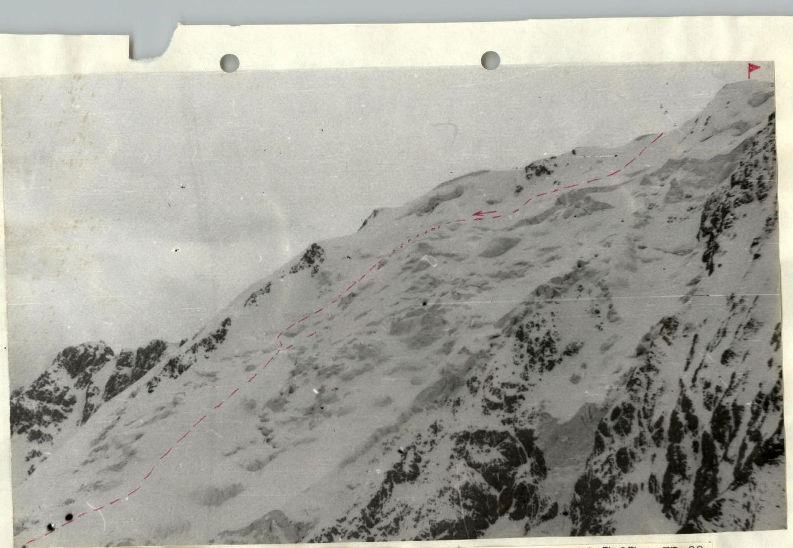
Photo 10. Profile of the North face of Palatka, descent path. Taken on July 18, 1989, at 13:00, "Vilia-auto". Shooting point #2.