Ascent Certificate
- ASCENT CLASS: technical
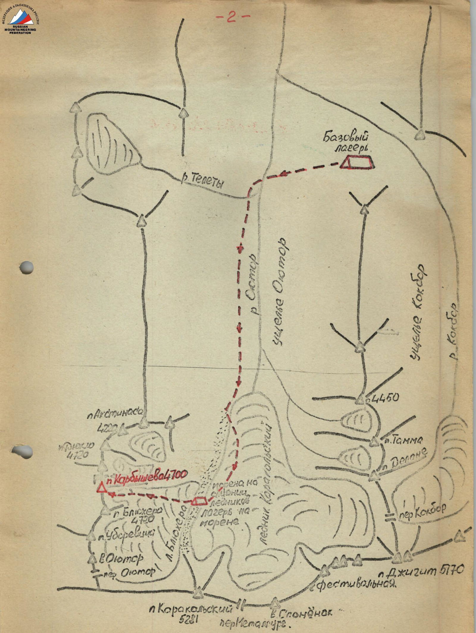
- ASCENT AREA: Tian-Shan, Ontor gorge, Kara-Kol area
- PEAK, ITS HEIGHT, ASCENT ROUTE: peak Karbyshev, 4700 m, via the center of the Eastern wall.
- PROPOSED DIFFICULTY CATEGORY: 5B
- ROUTE CHARACTERISTICS: rocky ELEVATION DIFFERENCE: glacier–summit 900 m, wall section 250 m. AVERAGE STEEPNESS: wall section 75–85°, entire route 40–50°. LENGTH OF 5–6 difficulty category sections: 280 m
- PITS DRIVEN: for belay — 60 pcs. for artificial footholds — 10 pcs., rock — 70 pcs.
- NUMBER OF CLIMBING HOURS: 23 h
- NUMBER OF NIGHTS AND THEIR CHARACTERISTICS: two nights in a tent on a snowy saddle of a lateral spur under the wall.
- SURNAME, NAME, PATRONYMIC OF THE LEADER, PARTICIPANTS, AND THEIR QUALIFICATION:
- Korolenko Anatoliy Yakovlevich — 1st sports category — instructor
- Uchaev Anatoliy Sergeevich — 1st sports category
- Grigortsev Andrey Vasil'evich — 1st sports category
- Checherinda Vladimir Egorovich — 1st sports category
- TEAM COACH: — Korolenko Anatoliy Yakovlevich
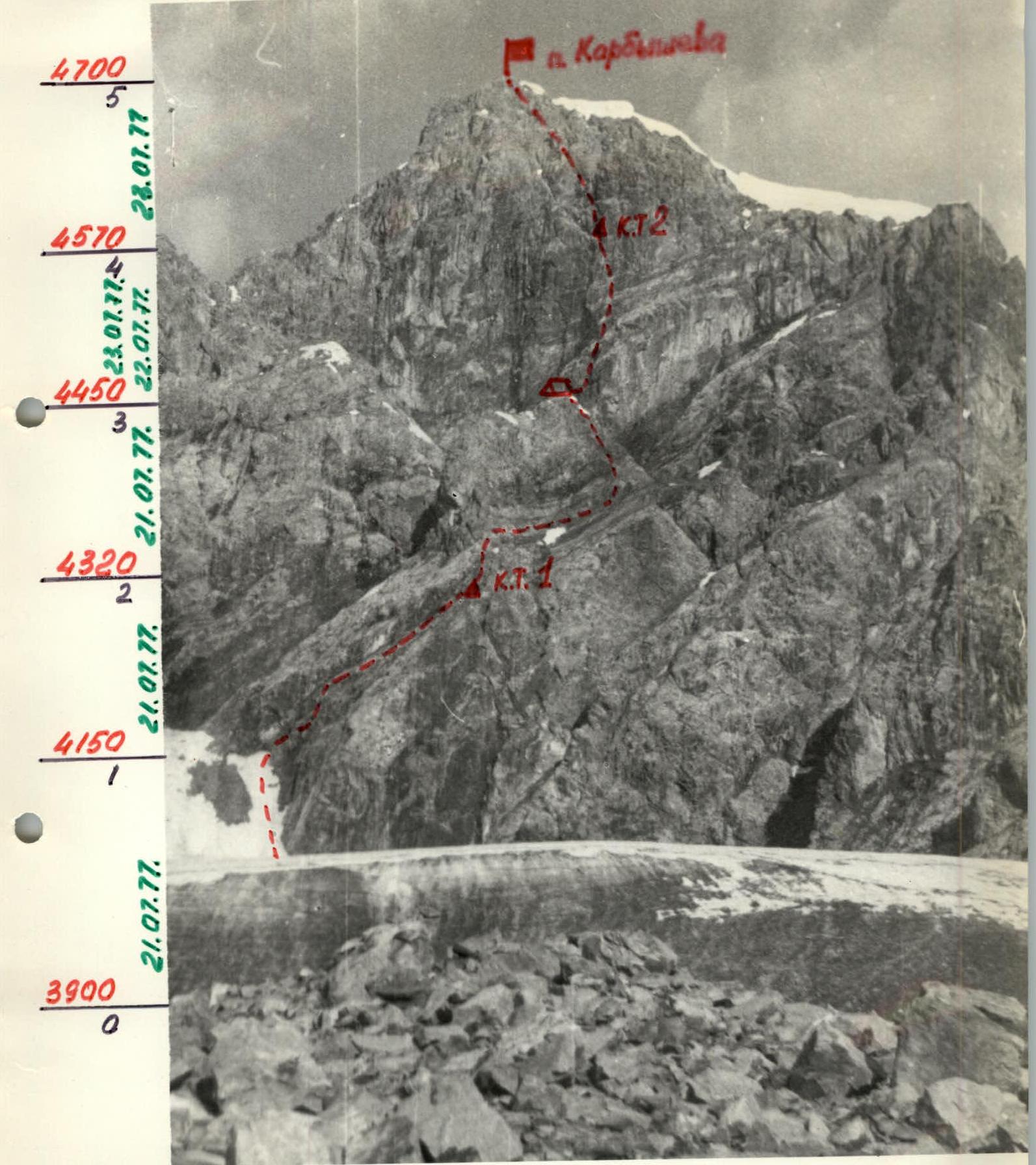
- DATE OF DEPARTURE ON THE ROUTE AND RETURN: July 20, 1977 – July 23, 1977
Description
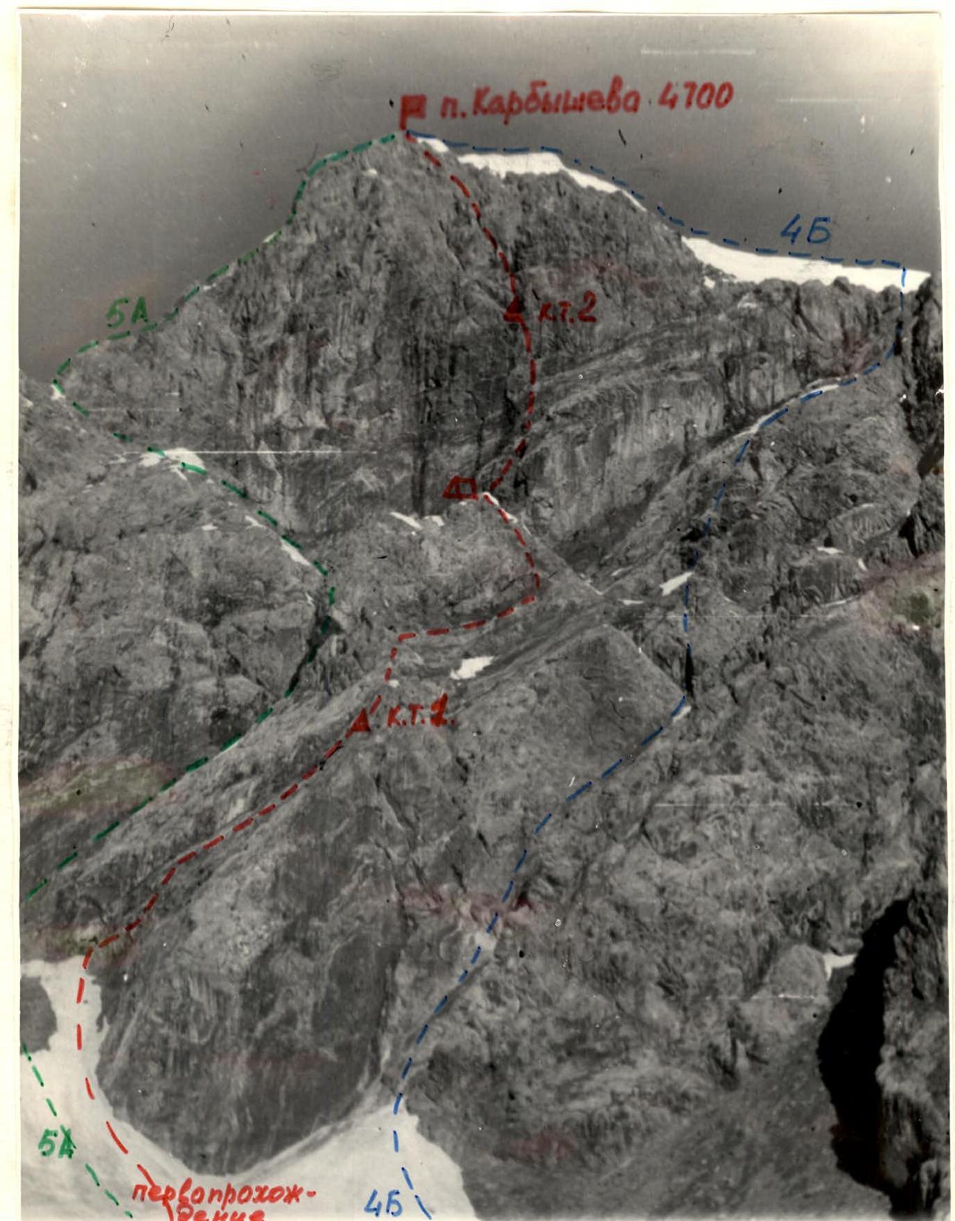
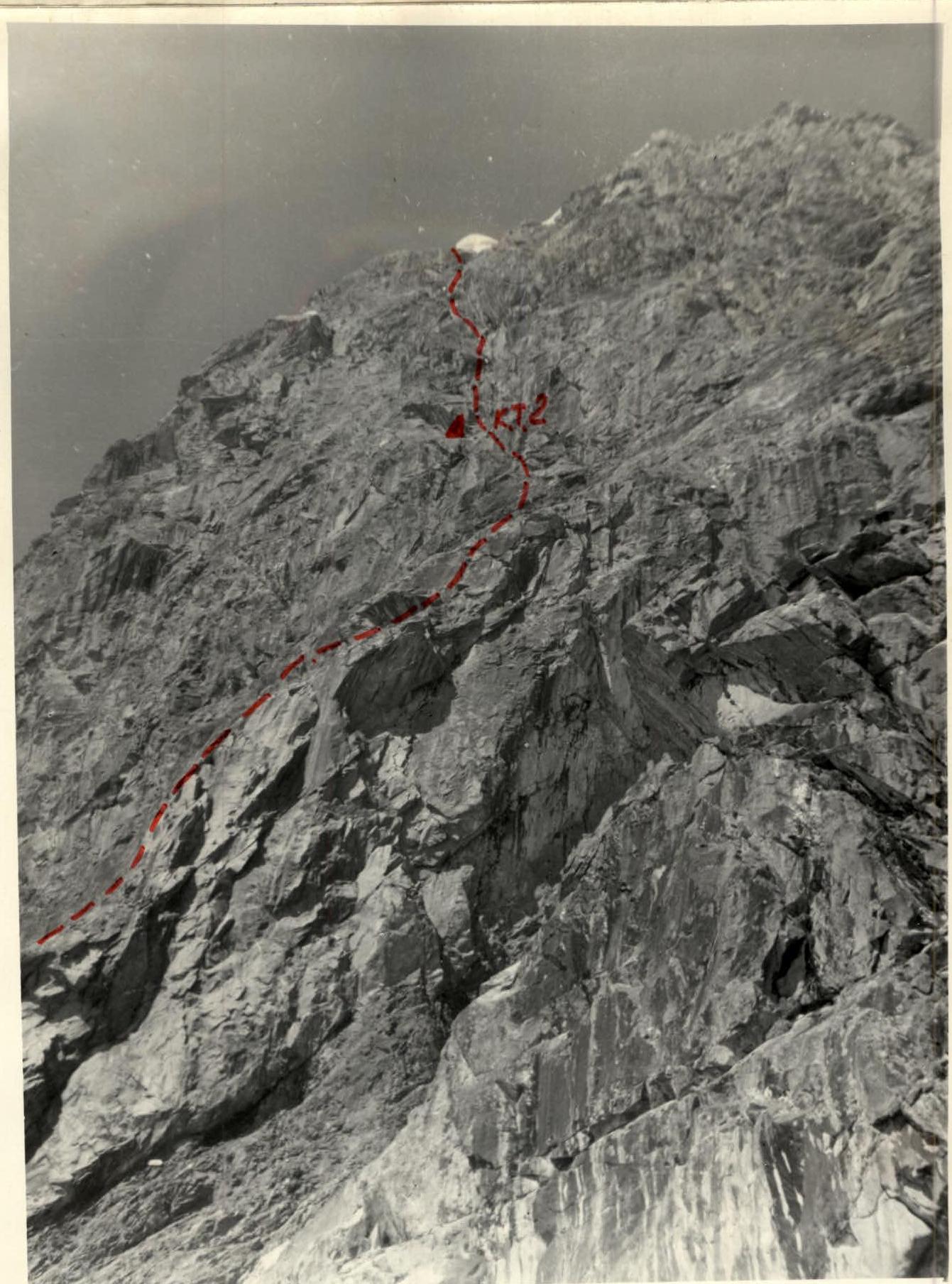
Route of the first ascent to peak Karbyshev via the center of the Eastern wall, 5B category of difficulty.
The path from the bivouac on the moraine at the confluence of the Karakol'skiy and Oyutor glaciers went through the Oyutor glacier in the direction of the eastern spur of peak Karbyshev. The spur is bypassed on the left (in the direction of travel) along the moraine with an exit to the cirque glacier between peaks Blyukhera and Karbyshev. Under the slopes of peak Karbyshev, we ascend along a steep snow-firn slope, under the overhanging black wall to the right of the stream flowing from the wall (be careful — rockfall). Under the overhanging wall — to the right upwards along inclined slabs with smoothed footholds — 180 m (pit belay) — with an exit to a vertical inner corner (destroyed rocks, difficult climbing), through which after 10 m — exit to the main platform (control cairn 1).
From the platform upwards (10–15 m) along the wall — exit to a rocky destroyed ridge (pit belay). Further, the ridge is traversed to the right (80 m) to a snow-ice couloir, leading to the left to a snowy saddle under the wall.
Along the left (in the direction of travel) side of the couloir, which is a steep smoothed ridge 50–60 m upwards to the snowy saddle.
Under the wall, a bivouac is possible on a snowy ridge.
From the overnight stay to the left of the overhanging wall along smoothed slabs with a steepness of 50–55°, flooded with water (ice in the morning) — to a small inner corner, from where to the right upwards (8–10 m) — exit to destroyed shelves. Along the shelves 40–50 m straight up — under the red destroyed wall, along the walls (30–40 m): first to the left upwards — to an overhanging ledge, then traverse along a steep slab with insignificant footholds — under an overhanging wall.
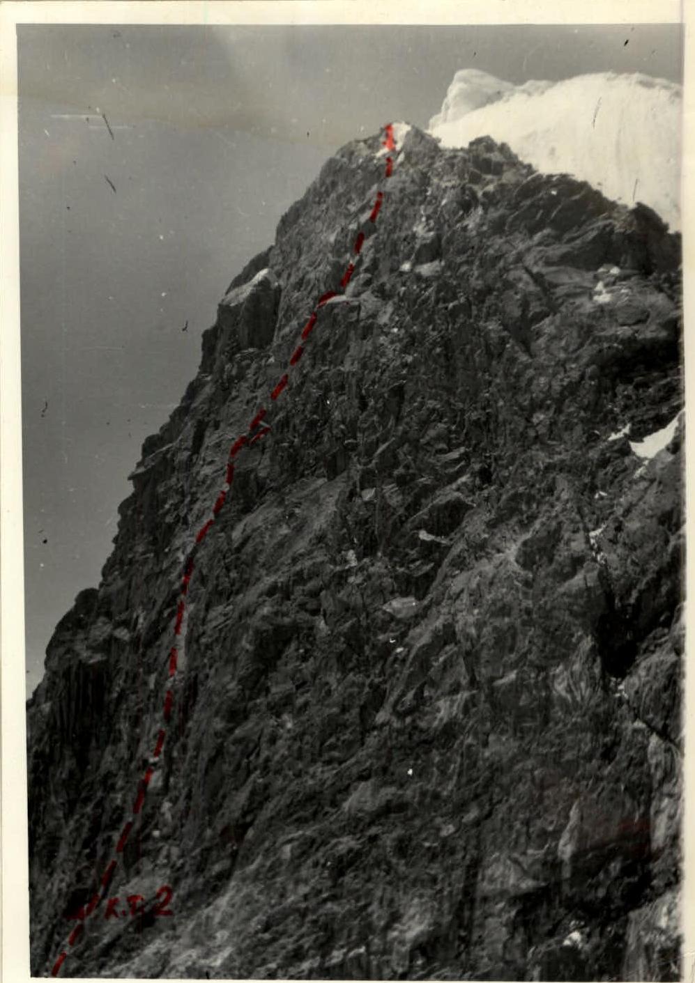
Further to the left upwards under the wall along steep (60–70°) smoothed slabs — exit under the second inner corner. Along the corner (10–12 m) to the left upwards — with an exit to a platform (control cairn # 2) (difficult climbing, pit belay).
Overnight stay is possible. From the control cairn — exit along a crack straight up (6–10 m). Further to the right under an overhanging cornice. The cornice is passed using ladders. Further traverse along steep shelves to the left upwards under the second rusty overhanging cornice. The cornice is passed in the right part using ladders (live rocks).
Exit to a steep slab (30 m), turning into a wall. Along the slab upwards under an overhanging grey wall to the right, forming a chimney in the upper part (narrowing and overhanging in the upper part). The chimney is closed by a plug.
The plug is bypassed on the left along the wall with an exit to a small platform, starting from control cairn # 2. Backpacks must be pulled out (in some places with assistance).
The path from the platform goes along the wall upwards 20 m with an exit to an indistinctly expressed ridge. Along its left side, we exit to a large inner corner — a crevice (beginning of the couloir). Crossing it along an inclined shelf-slope, after 50–60 m we exit to a scree shelf under the summit. To the summit 10 m (overnight stay is possible).
After control cairn # 2 — descent from the route is possible only via the ascent route due to overhanging slabs of great length. Descent from the summit along the northern ridge.
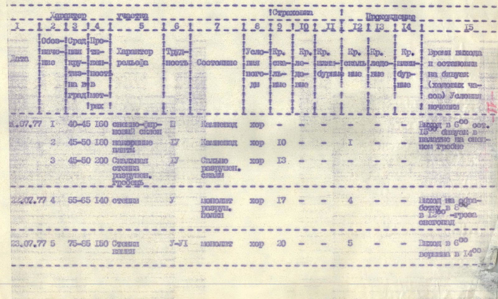
| Date | Section | Terrain characteristics | Designation of control points | Average steepness | Length | Condition | Weather conditions | Pits | Pits driven | Pits exit | Rock pits | Ice pits | Bolt pits | Time of departure and overnight stay conditions |
|---|---|---|---|---|---|---|---|---|---|---|---|---|---|---|
| 20.07.1977 | R1 | Snow-firn slope | 1 | 40–45° | 160 m | Rockfall | good | — | — | — | — | — | — | Departure at 6:00. 15:00 — bivouac in a tent on a snowy ridge. |
| R2 | Inclined slabs | 1 | 45–50° | 100 m | Rockfall | good | 10 | — | — | 1 | — | — | ||
| R3 | Rocky ridge, destroyed wall | 1 | 45–50° | 200 m | Severely destroyed rocks | good | 13 | — | — | — | — | — | ||
| 21.07.1977 | R4 | Walls | 1 | 55–65° | 140 m | Monolith, destroyed rocks | good | 17 | — | — | 4 | — | — | Departure for processing at 8:00. At 12:00 — thunderstorm, snowfall |
| 22.07.1977 | R5 | Walls | 1–2 | 75–85° | 150 m | Monolith | good | 20 | — | — | 5 | — | — | Departure at 6:00. Summit at 14:00 |


