
Ascent Passport
- Ascent category: Traverse
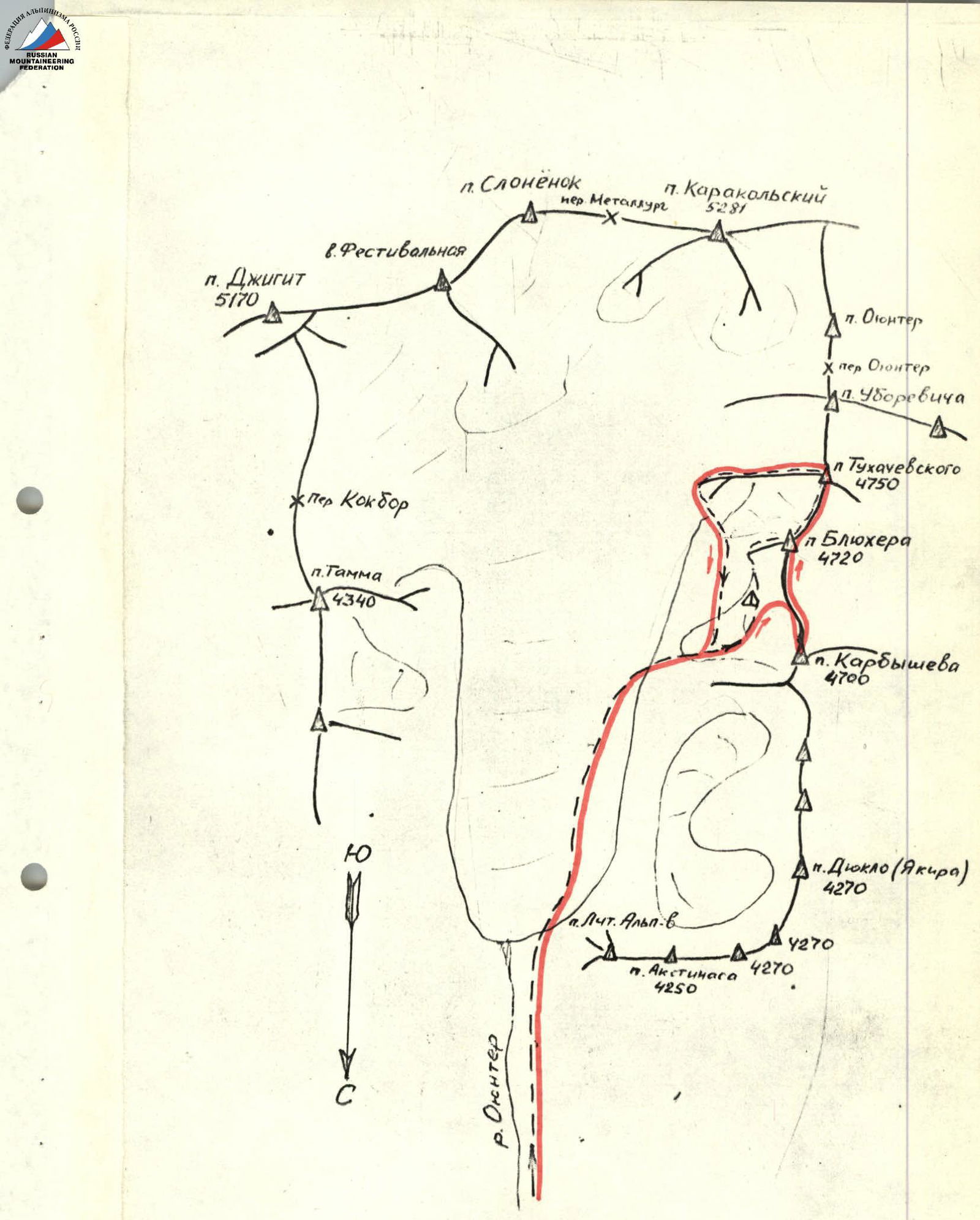
- Ascent region: Tian-Shan, Terskey-Alatau
- Ascent route: Traverse of Peaks Karbyshev, Blyukher, and Tukhachevsky from north to south, ascending Peak Karbyshev via the southern edge.
- Ascent description: Ascent to Peak Karbyshev is category 5A difficulty. Traverse length is 2600 m. Height difference between peaks and cols is 400 m. Length of technically difficult sections is 850 m.
- Number of pitons: Rock - 142, ice - 15
- Total climbing hours: 36.5
- Number of bivouacs and their characteristics: 2 bivouacs, lying down.
- Team name: Zenit Regional Council Team
- Leader's and participants' full names and qualifications: Penchuk V.L. - Master of Sports (team leader) Zhurzadin V.I. - Candidate Master of Sports (participant) Kalinychev B.S. - Candidate Master of Sports (participant) Sedov G.K. - Candidate Master of Sports (participant)
- Team coach: Master of Sports Penchuk V.L.
- Date of departure and return: August 1-5, 1976
Ascent Route Description
August 1. The path from the "Ala-Too" base camp to Peak Karbyshev and the ascent to the summit (via the 5A category route) are well-known and are described briefly here.
The approach to the start of the route follows the right (in the direction of travel) bank of the Oyun-Tor gorge, then along the right moraine of the Karakolsky glacier to where the Karbyshev glacier flows into it. Then, along the right side of the Karbyshev glacier to the beginning of the eastern counterfort of Peak Karbyshev, at the foot of which the group set up a bivouac (7 hours from the base camp).
August 2. Departure at 7:00. The ascent to Peak Karbyshev begins from the base of the inner angle formed by the southern wall of the peak and the eastern slope of the ridge on which the summit is located. The edge of this angle is a narrow couloir that steeply ascends 400 m upwards to the vertical southern wall of the peak (R1). The route immediately becomes wall-like.
Here (R1), the most challenging section is the transition from the narrow throat of the couloir and then exiting via the wall on the right side of the couloir to the southern wall of Peak Karbyshev. The wall is like a "ram's forehead" with no alternative routes:
- to the right - overhanging sections;
- to the left - rockfall-prone part of the couloir (photo).
It should be noted that the entire lower part up to this point should be traversed in the early hours, as rockfalls are frequent here after sunrise.
Then 250 m along the southern wall left-upwards to the col in the ridge (R2). Here, simple sections alternate with sections of complex climbing on snow-covered and ice-covered rocks with a steepness of up to 80-85° and a length of 30-40 m. The group took 10 hours to ascend to the col. Here, it was decided to start searching for a bivouac site so that the next day they could ascend to Peak Karbyshev via the southern edge without backpacks.
The entire ridge between Peaks Karbyshev and Blyukher is 2 km long and has a sharp, knife-like character with significant jaggedness. To the left, south of the col, begins the ascent to a gendarme (R4) (40 m, piton belay). The ascent to the gendarme is direct (slabs) and descent (20 m) to the ridge. Here, on a snow slope, a bivouac site was dug out (R5).
August 3. Departure at 6:00. Returning to the col at the southern edge of Peak Karbyshev and ascending to the summit via it (R3; 400 m). Here - steep slab-like rocks, partly with ice. The ledges are snow-covered and covered with ice.
The wide, snow-covered inner angle before reaching the summit requires care and thorough belaying, as a thin layer of snow lies on hard ice. To the summit - 2 hours 30 minutes.
Returning from the summit to the bivouac (1 hour), they pack up and continue the traverse to Peak Blyukher.
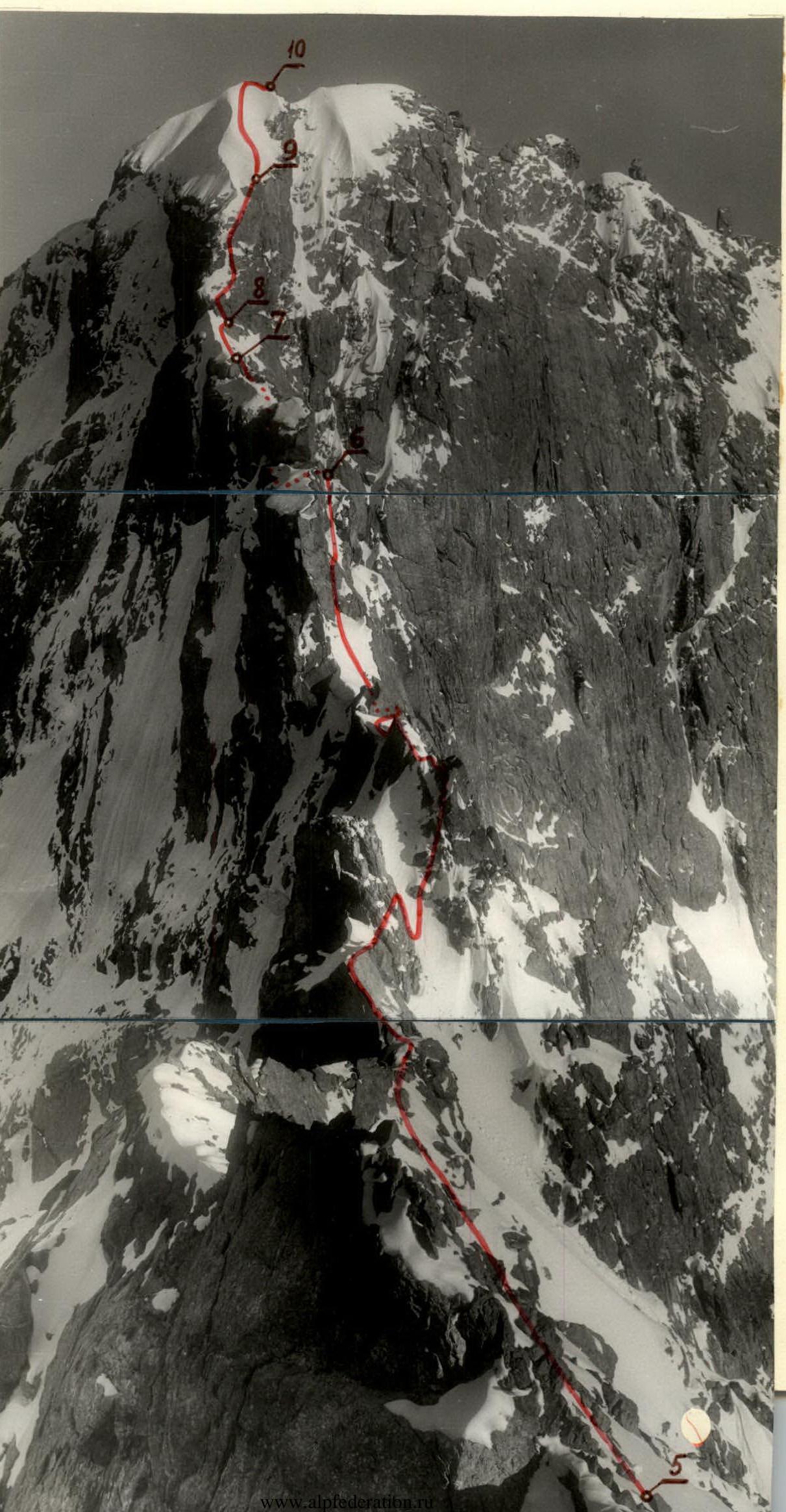
The route (photo) predominantly follows the right side of the ridge. The route is mainly rock, often slab-like in character, with some snow and ice on the slabs. Belaying is via pitons and through rock outcrops and ridge bends. Small gendarmes (20-30 m):
- are either bypassed on the right via indistinct ledges,
- or ascended directly (R6).
The gendarme before the wall leading to the eastern summit of Peak Blyukher is overcome by ascending the wall to the right (in the direction of travel). The 30-meter (90°) wall of the gendarme was ascended using artificial holds, with piton belaying (R7). Here, backpacks are pulled up. Exit to a ledge.
From the ledge, 40 m along the right side of the steep snow-ice ridge to the base of the northern wall leading from the ridge to Peak Blyukher. Via the wall (R9, 100 m, 75°) - exit to the pre-summit snow-ice slope (piton belaying, complex climbing on slabs partly covered with ice and snow).
Along the snow-ice ridge (R10, 80 m, 55°) - exit to the summit of Blyukher. Here, on a small platform, a site was prepared from stones and snow for a tent, and a control cairn was erected. From the previous bivouac - 2 hours 30 minutes.
August 4. Departure at 8:00. From the summit of Peak Blyukher, descend 10 m to the eastern side of the ridge and then to the right under an overhanging 20-meter snow cornice (the group passed here in the early morning hours) and along the left side of the heavily jagged ridge - to the col before the summit of Peak Tukhachevsky.
In the notch - a sharp snow-ice ridge (20 m). From the ridge, directly upwards via the wall (60 m, 70°) to the summit of Peak Tukhachevsky (R11).
From the summit:
- descend via a snow slope to the left side of the ridge,
- then via rocks of medium difficulty to the beginning of the descent via the eastern wall of Peak Tukhachevsky on the 4A category route to the original bivouac.
On the descent:
- 4 sport descents,
- one 50 m rappel,
- then via steep, rocky ledges to the Karbyshev glacier to the original bivouac.
Here, at 18:00, the group set up a bivouac, with heavy rain and wet snow.
August 5. Departing the bivouac at 9:00, the group returned to the "Ala-Too" base camp.
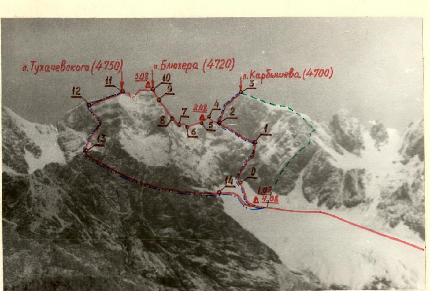 Traverse of Peaks Karbyshev - Blyukher - Tukhachevsky
Route traversed by the Zenit Regional Council Team
Traverse of Peaks Karbyshev - Blyukher - Tukhachevsky
Route traversed by the Zenit Regional Council Team
- Category 5A route to Peak Karbyshev
- Category 4B route to Peak Karbyshev
- Category 4A route to Peak Tukhachevsky (4750)
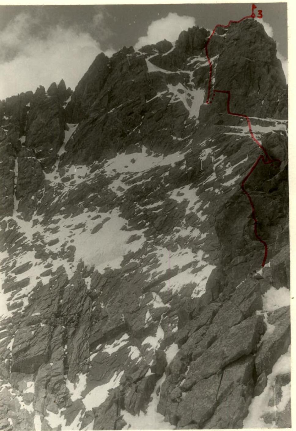 Southern edge of Peak Karbyshev (4700 m)
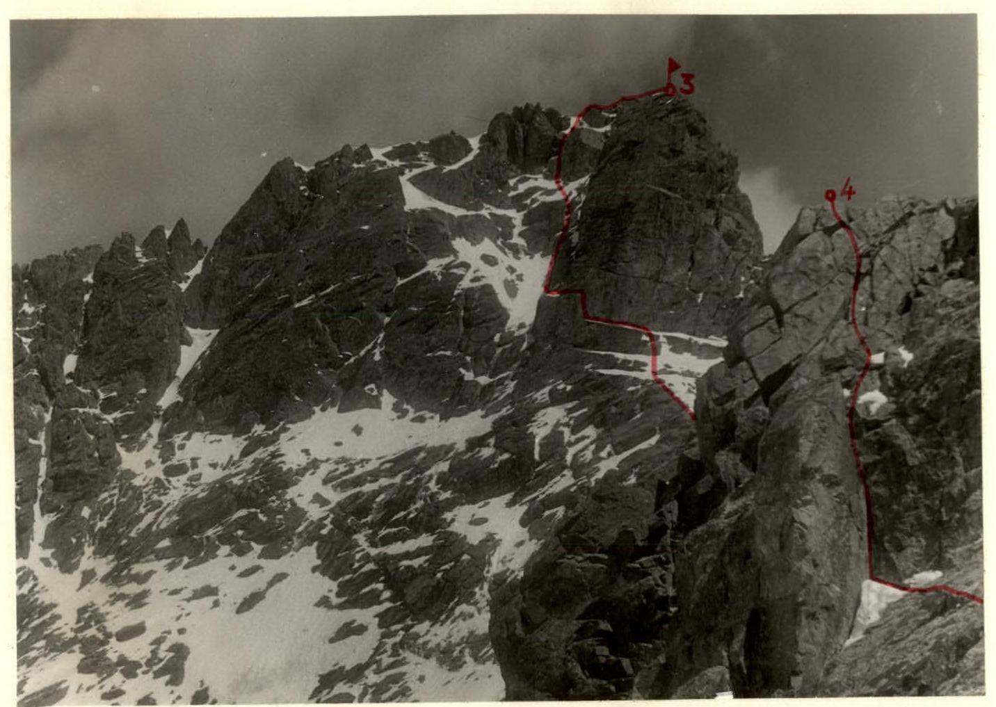 Southern edge of Peak Karbyshev (4700 m) and descent path from the 1st gendarme.
12
1
 Section 11
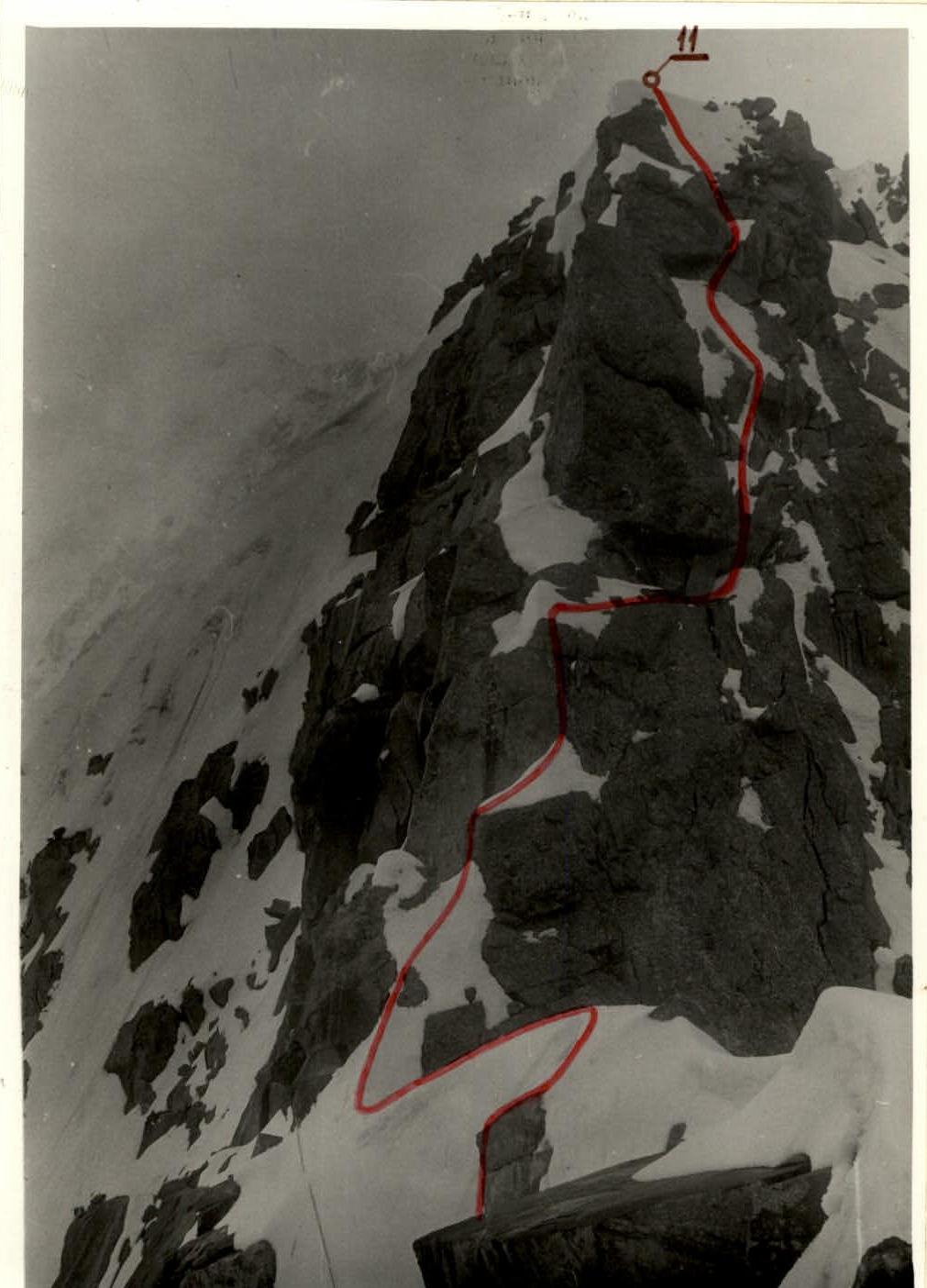
Table of Main Characteristics
Ascent route: Traverse of Peaks Karbyshev, Blyukher, and Tukhachevsky from north to south.
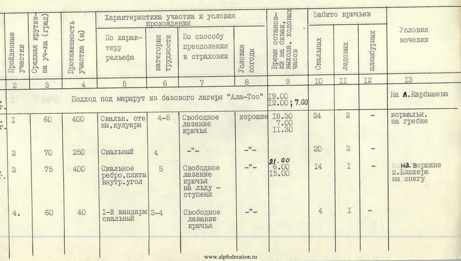
| I | 2 | 3 | 4 | 5 | 6 | 7 | 8 | 9 | IO | II | I2 | I3 |
|---|---|---|---|---|---|---|---|---|---|---|---|---|
| Approach to the route from the "Ala-Too" base camp | 19:00, 12:00; 7:00 | to Peak Karbyshev | ||||||||||
| 1 | 60 | 400 | Rock walls, couloir | 4–5 | Free climbing, pitons | good | 18:30, 7:00, 11:30 | 24 | 2 | normal, on the ridge | ||
| 2 | 70 | 250 | Rock | 4 | -"- | -"- | 20 | 3 | ||||
| 3 | 75 | 400 | Rock edge, slabs, inner angle | 5 | Free climbing, pitons on ice, steps | -"- | 21:00, 6:00, 15:00 | 14 | 1 | on the summit of Peak Blyukher on snow | ||
| 4 | 60 | 40 | 1st gendarme, rock | 3–4 | Free climbing, pitons | -"- | 4 | 1 | - | |||
| 5 | 70 | 20 | Rock | 4 | Sport descent | good | 2 | |||||
| 6 | 350 | Sharp ridge, slabs | 21 | 2 | ||||||||
| 7 | 90 | 30 | Slab, wall | 5 | Artificial holds, pulling up backpacks | -"- | 6 | 2 | - | |||
| 8 | 40 | 40 | Snow, ice | 3 | Free climbing, steps | -"- | ||||||
| 9 | 75 | 100 | Wall, slabs, rime ice | 5 | Free climbing, pitons (first without backpack) | -"- | 21 | 1 | - | |||
| 10 | 50 | 80 | Snow-ice ridge | 4 | Free climbing, steps, ice axe belay | -"- | 1 | 2 | - | |||
| 11 | 200 | Rock snow-ice ridge, wall | 4 | Free climbing, pitons | -"- | 18:00, 8:00, 10:00 | 8 | on the Karbyshev glacier on snow | ||||
| 12 | 300 | Rock-snow ridge | 4 | Free climbing, pitons | good | 6 | 1 |
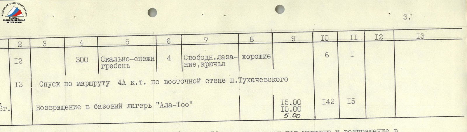 Total: 48.5 hours (including 12 hours for approach to the route and return to the "Ala-Too" base camp).
Conclusion
The Zenit Regional Council Team has for the first time traversed Peaks:
- Karbyshev (4700 m),
- Blyukher (4720 m),
- Tukhachevsky (4750 m), representing a technically complex, combined route.
The route was traversed in good weather conditions. The route can be conditionally divided into five parts:
-
- A categorized 5A category route to Peak Karbyshev via the southern edge.
-
- A first-time combined ridge route from Peak Karbyshev to Peak Blyukher.
-
- A first-time wall route to Peak Blyukher.
-
- A first-time ridge route between Peaks Blyukher and Tukhachevsky.
-
- A previously traversed 4A category route to Peak Tukhachevsky via the eastern wall - the descent path from the traverse.
It should be noted that Peak Blyukher was climbed for the first time during this traverse.
The most technically challenging part of the route is the third. Here, mainly monolithic, slab-like rocks are snow-covered and ice-covered. With insufficient climbing and rock climbing skills, the use of bolt pitons may be required here, and in bad weather, they are always necessary.
On some sections of the wall during the ascent to Peak Blyukher, using clamps, group members (excluding the leader) climbed with backpacks, thus minimizing the use of the inconvenient operation of "pulling up backpacks."
Overall, the route requires good all-around preparation of the group. In complex weather conditions, which must always be considered in this region, certain sections of the route demand maximum mobilization of all tactical and technical preparation means of the group members.
Comments
Sign in to leave a comment