PASSPORT
-
Snow-ice class.
-
Central Tien-Shan, Terskey-Alatau ridge.
-
Peak Karakolsky via the Northern face through "Zmeika", variation.
-
5B category of difficulty.
-
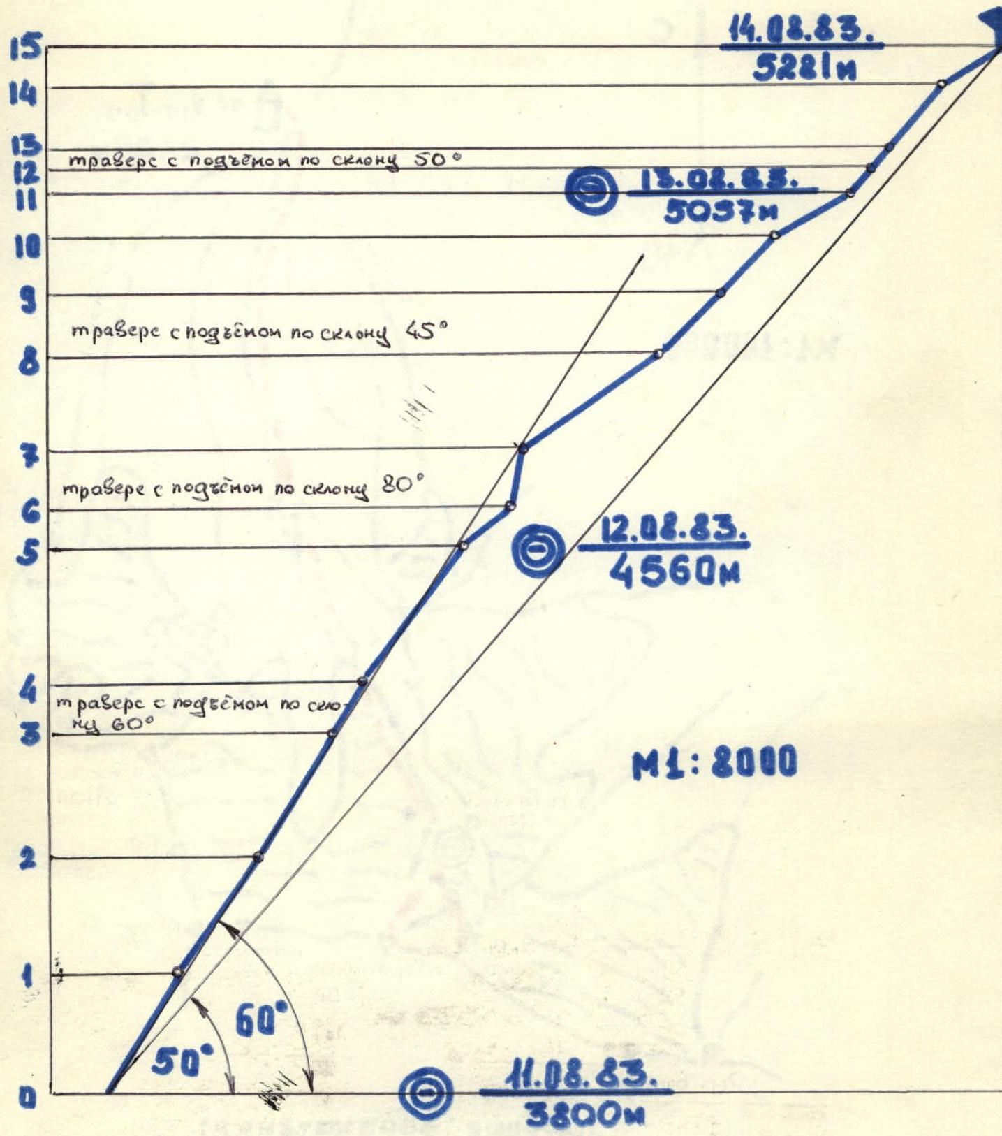
Elevation gain 1480 m, length 2050 m.
Length of sections with 5-6 category of difficulty is 1170 m. Average steepness of main sections is 60° (3800-4700).
-
Number of pitons:
rock pitons 34, drilled закладок 6, ice screws 153.
-
Climbing hours - 32, days - 3.
-
Overnights: 1st - lying on a platform carved out on a snow-ice saddle; 2nd - lying on a platform trampled in a snow mulda.
-
Team leader: N. A. Nekrasov, Candidate Master of Sports.
Team members: A. M. Chastov, Candidate Master of Sports; Yu. D. Vushmanov, 1st sports category; V. M. Suponitskiy, 1st sports category.
-
Coach: S. S. Tulpanov, Master of Sports of the USSR.
-
Approach to the route - August 12, 1983.
Summit - August 14, 1983. Descent - August 14, 1983.
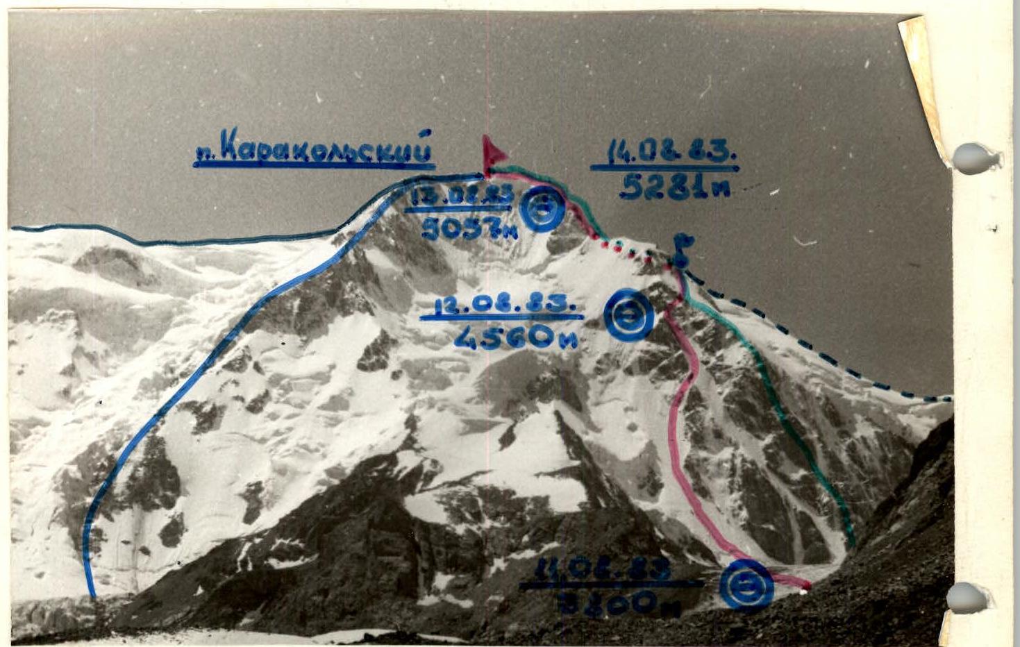
Photo 1. General photo of the summit. Legend: — team route; — route via NW ridge, 5B category of difficulty; — — — route via W ridge, 4B category of difficulty; — route via NE ridge, 5A category of difficulty; • control cairn; ⦾ overnight locations. Photo taken on August 10, 1983, at 13:00, lens Industar 26M, F = 5 cm, distance to the summit 4.5 km, point 1 - 3270 m.
Route Profile
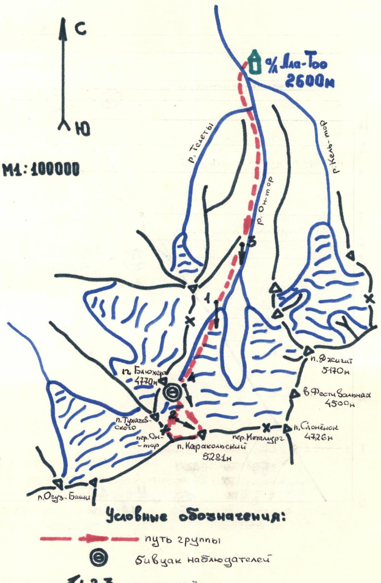
Map of the Ascent Area
Brief Overview of the Ascent Area
Like most mountain ranges of Tien-Shan, Terskey-Alatau stretches in a latitudinal direction, forms an arc slightly curving around Issyk-Kul, and rises above the lake level by 3000 m. The length of Terskey-Alatau is about 340 km, and the ridge merges with Kungey-Alatau in the east.
From west to east, up to the gorges of Karakol and Arashan:
- the height and degree of glaciation of the ridge increase;
- the amount of precipitation in the high-altitude zone sharply increases - up to 2000 mm.
Terskey-Alatau is characterized by a deeply dissected alpine type of relief. The highest central part of the ridge is between the gorges of Baraskun and Turgen-Aktau, the highest point being Karakolsky Peak (5281 m) in the upper reaches of Oktar, the left tributary of Karakol. The ridge is the second-largest center of glaciation in Tien-Shan after the massif of Peak Pobeda and Khan-Tengri. There are about 1100 glaciers here, with a total area of 1081 km².
Abundant precipitation, weak evaporation, and low average annual temperatures create favorable conditions in the high-altitude zone of Terskey for the snow to not melt during the summer and accumulate in the form of firn fields and glaciers. The snow line is located on the northern slope of the ridge at an altitude of 3650 m.
Glaciers from the northern slope of the ridge are bordered by steep snowy slopes, reach 5-7 km in length with ice thickness of 60-90 m, and descend significantly below the snow line - down to 2900-3500 m.
The area attracted the attention of climbers in the late 1930s, when N. Popov ascended Peak Karakolsky in 1937, and V. Razek pioneered a route to Peak Dzhigit in 1939.
Currently, many diverse climbing routes have been laid out to the peaks of the area, including two 6B category of difficulty.
On the right bank of the river Ontor, at the confluence with the river Kelter, the "Ala-Too" alpine camp operates permanently, enjoying great popularity among climbers.
For more details, see the book by B.I. Rukavishnikov "Lake: Issyk-Kul and Terskey-Alatau Ridge", FiS, Moscow, 1970.
Tactical Actions of the Team
The ascent of Peak Karakolsky via the Northern face proceeded in full accordance with the tactical plan submitted to the KSP of the area, with no deviations. The determining factors in its preparation were ensuring complete safety and speed of passage. The lower section of the wall, where rockfall is possible from the 8th hour, was climbed early in the morning, while the wall was still in shadow. During reconnaissance and observation of the route, a diagram of snow and ice avalanches was compiled. It was found that there were no signs of avalanches or ice collapses on the route itself.
During the ascent, the following technical and tactical actions were carried out:
- The first climber worked on a double rope with a standard Czech shock absorber (type I-250 kg).
- On steep sections of 6-5 category of difficulty, one of the ropes was fixed as a handrail, and the other served as upper belay for the second climber, who climbed up to the first and brought another rope and pitons.
- The second rope team climbed up the handrail using jammers and additional belay through a prusik knot.
- The first climber from the second rope team tied an additional knot on one of the intermediate pitons while passing the handrail, ensuring the possibility of simultaneous movement of participants on the upper and lower sections of the handrail.
- On sections of 4-5 category of difficulty, the rope teams worked independently, interacting via left belay points, with the second climber in each team using upper belay.
- On sections of 3-4 category of difficulty, the pairs moved simultaneously, organizing belay through pitons, закладки, and natural forms of mountain relief.
- On section 7, the first climber went with a lightened rucksack (containing only a down jacket and one boot).
On August 13, 1983, the team reached the planned overnight location (point 8) at 15:00, and there was still time to reach the summit and overnight on the descent. However, the weather was deteriorating, a thunderstorm was approaching, and ascending to the summit in such conditions would be hazardous, so they stopped for the night at the planned location.
On the route, the lead climber was constantly changed, ensuring rapid progress. There were no falls or injuries. The team climbed the route at a good pace, demonstrating good physical and technical preparation. Communication with the observation group was constant and reliable. In addition to the main communications at R8, R12, R16, R20, the observers checked in every even hour.
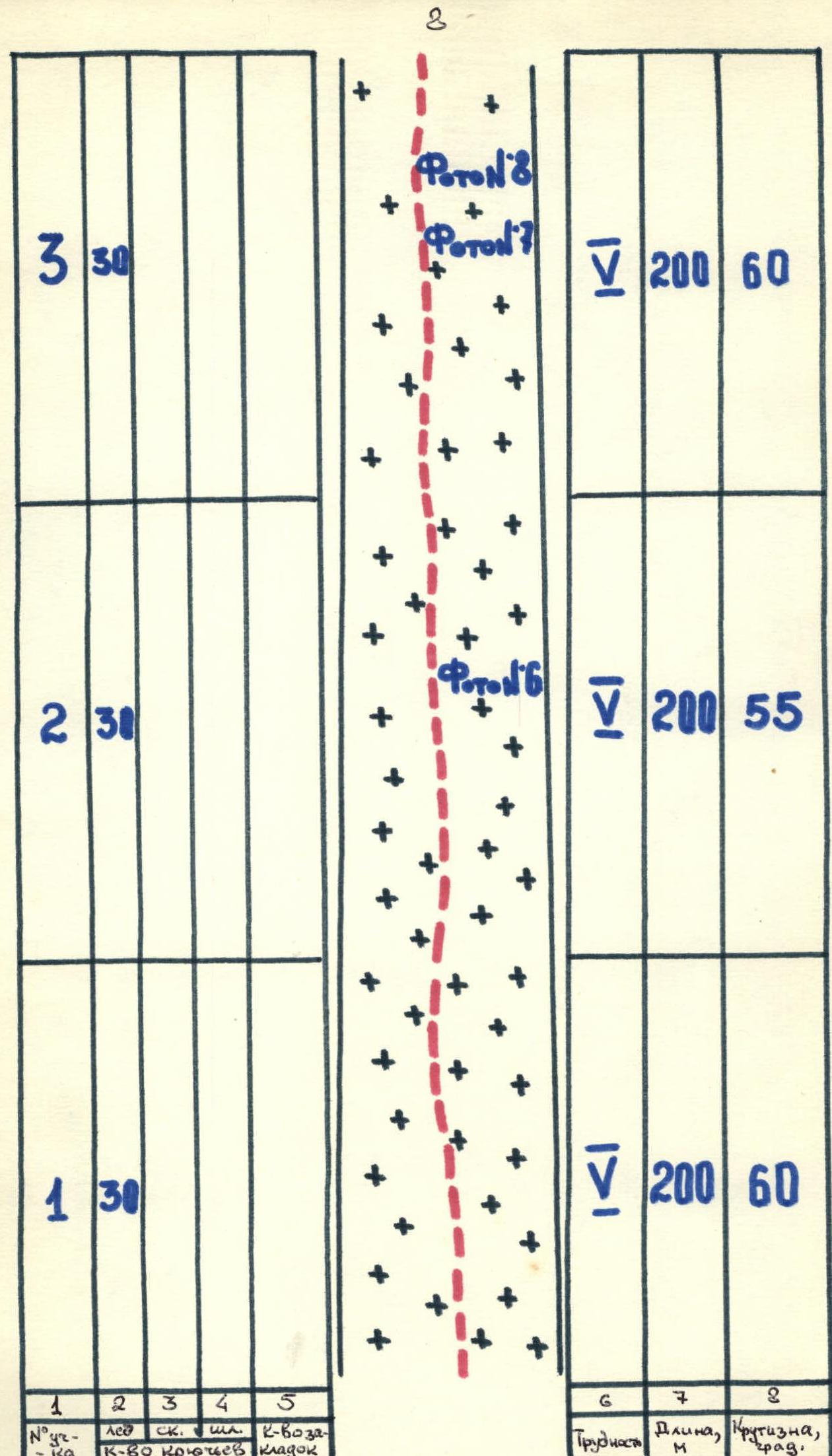
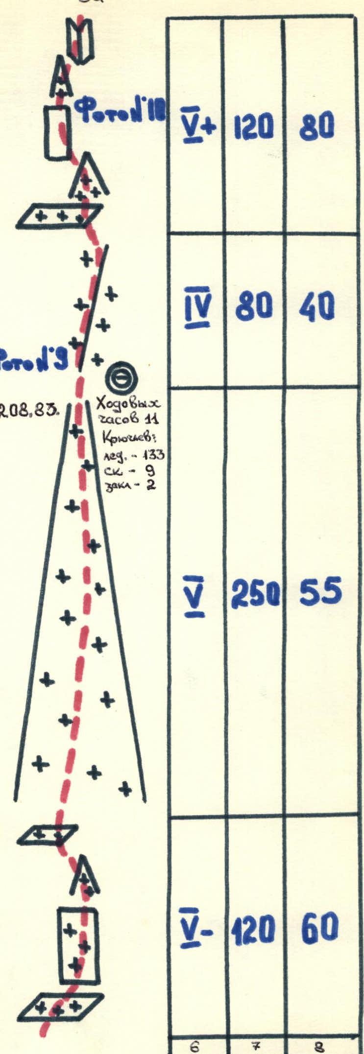
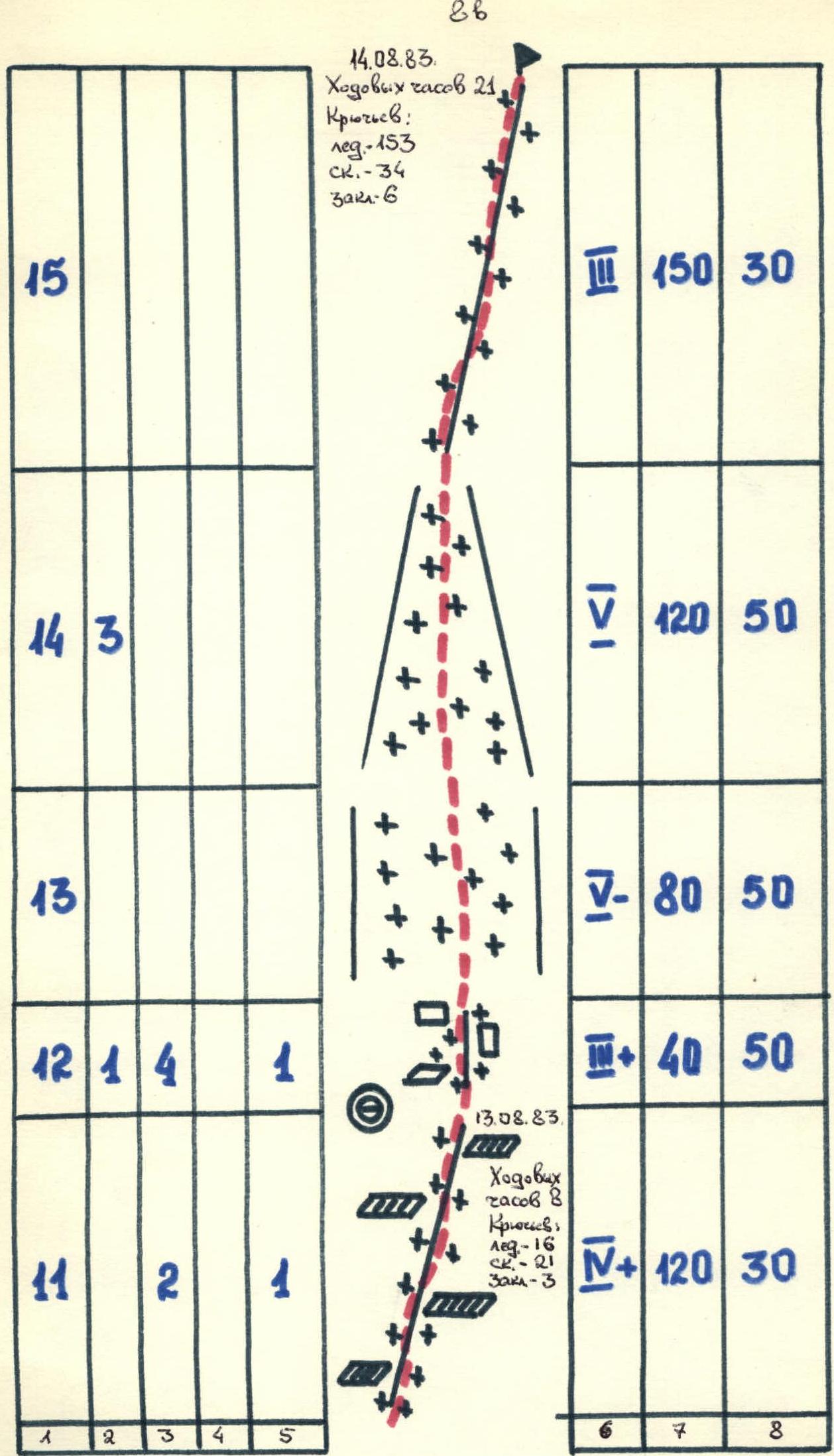
| Section № | Category of difficulty | Length, m | Steepness, ° | Photo № |
|---|---|---|---|---|
| R1 | 5 | 200 | 60 | №8, №7 |
| R2 | 5 | 200 | 55 | №6 |
| R3 | 5 | 200 | 60 | №3, №7 |
| R4 | 5 | 120 | 60 | |
| R5 | 5 | 250 | 55 | |
| R6 | 4 | 80 | 40 | |
| R7 | 5 | 120 | 80 | №18 |
| R8 | 4 | 250 | 35 | №11, №12 |
| R9 | 4 | 150 | 45 | |
| R10 | 3 | 120 | 45 | |
| R11 | 4 | 120 | 30 | |
| R12 | 3 | 40 | 50 | |
| R13 | 5 | 80 | 50 | |
| R14 | 5 | 120 | 50 | |
| R15 | 3 | 150 | 30 |

Route Description by Sections
From the "Ala-Too" alpine camp, ascend along the right (in the direction of travel) bank of the Ontor river to the tongue of the glacier, then along the right (in the direction of travel) side of the glacier, approach the slopes of Peak Tukachevsky, where there are convenient and safe overnight locations directly opposite the route. The total travel time from the camp is 4.5-5 hours.
From the overnight locations, cross the glacier and ascend the powerful avalanche cone to the bergschrund. The bergschrund is crossed in the uppermost part of the avalanche cone, where it is almost filled with snow. Then ascend up the ice wall to the left of the counterfort - a 600 m approach under the rocks. Then, to the right and up the rocks, covered with snow and filled with ice, cross the counterfort and enter the ice couloir, which separates the route via the N face through "Zmeika" and the route via the NW ridge - also 5B category of difficulty. Ascend the couloir for 250 m, and at the end of the couloir, exit onto a narrow snow-ice ridge abutting the "rusty" rock wall. Overnight on the ridge. From the overnight location, ascend along the ridge for 80 m under the wall, and then to the right and up the steep rocks and couloirs filled with ice - 120 m to exit onto a gentle (35°) snow-firn slope. Climbing is extremely difficult, with rocks covered in snow and filled with ice. Along the snow-firn slope, to the right and up for 250 m to a small ridge with rock outcrops. On the rocks, a control cairn. Then traverse to the left and up along the snow-firn slope for 150 m to a clear saddle. In the ridge - at the base of a rock tower. From the saddle, ascend the rocks for 120 m and exit onto a very narrow ridge with cornices (careful belay!). Along the ridge for 120 m - approach to the second rock tower. Overnight under the tower. From the overnight location, ascend to the right and up the rocks for 40 m - exit onto an ice-firn slope. Along the slope for 80 m - traverse and ascend 120 m along the ice-firn couloir to the summit snow pad. Along the pad for 150 m to the summit of Peak Karakolsky.
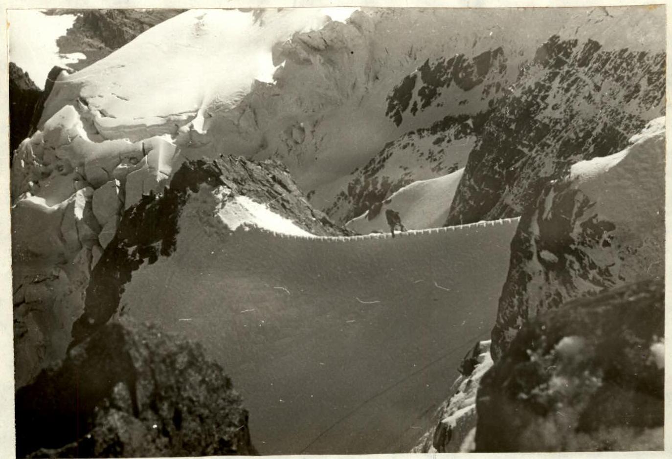
Photo №10. Section №7. Taken on August 13, 1983, at 9:00, lens Industar 26M, F = 5 cm, point №10, 4450 m.
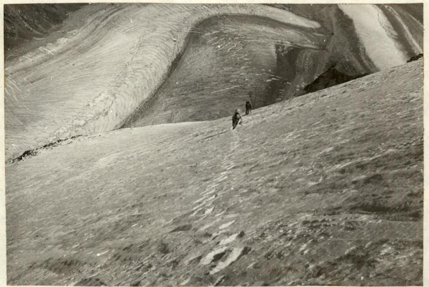
Photo №11. Section №8. Taken on August 13, 1983, at 12:30, lens Industar 26M, F = 5 cm, point №19, 4780 m.