- Technical category
- Tian-Shan, Terskey-Alatau ridge, Kok-bor gorge
- Peak Jigit (V), 5170 m, via NE ridge (Furman, 73)
- Category of difficulty — 5B
- Height difference — 1370 m
Length — 1840 m Length of sections with 5–6 category of difficulty — 540 m Average steepness of main sections 63° (4100–4950) Including 6 category of difficulty (40 m) — 82° (4350–4360; 4470–4480; 4800–4820)
- Pitons hammered in:
| Type of pitons | Number |
|---|---|
| Rock | 25 |
| Bolt | 0 |
| Chocks | 49 |
| Ice screws | 97 |
- Team's travel time: 38 hours, 4 days
- Overnights: 1st — ice-cut platform; 2nd — hanging on an ice-covered rock wall (tent "bag-like" inserted into a rope "basket"); 3rd — ice-cut platform.
- Leader: Molodykh Valery Gennadievich
Team members:
- Kovgan Vladimir Grigorievich (CMS)
- Kovensky Evgeny Isaakovich (CMS)
- Shibun Vasily Stanislavovich (CMS)
- Lobach Viktor Stepanovich (1st sports category)
- Metko Alexander Vladimirovich (1st sports category)
- Coach: Kovensky Gennady Isaakovich
Approach to the route: August 1, 1993 Summit — August 4, 1993 Return — August 4, 1993
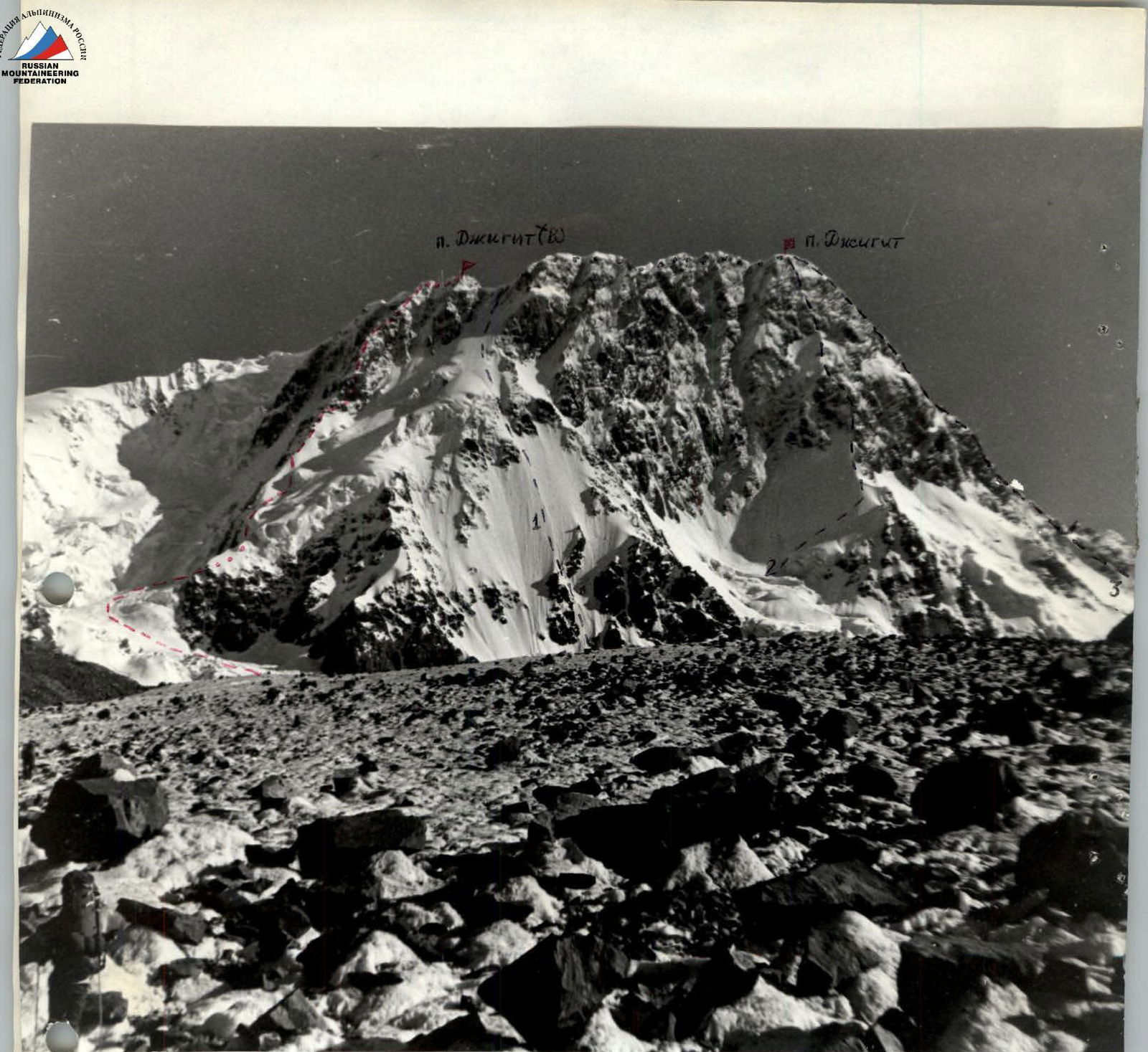
- General view of p. Jigit. Taken on July 31, 1993, from Kok-bor gorge. Distance 3.5 km.
Routes shown:
- 1 — via S. wall seracs, 5B
- 2 — via S. wall, 5B
- 3 — via NW wall, 5B
- — route taken

via CA ridge, group's technical category 55
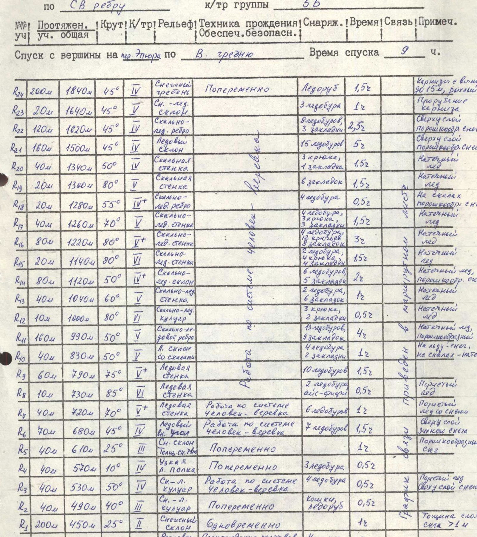
Tactical plan and route description to Peak Jigit (V)
Via NE ridge, group category 5B
| Section # | Section length (m) | Distance from summit (m) | Steepness (°) | Technical category | Terrain | Passage technique | Equipment | Time (hours) | Communication | Notes |
|---|---|---|---|---|---|---|---|---|---|---|
| R1 | 200 | 1840 | 45 | 4 | Snow ridge | Alternating | Ice axe | 1.5 | Cornices with 90° overhangs, loose unreliable snow. | |
| R2 | 20 | 1640 | 45 | 1 | Snow-ice slope | Chopping steps | 3 ice screws | 1 | cornices | |
| R3 | 120 | 1620 | 45 | 4 | Rock-ice ridge | Upper layer | 3 ice screws | 2.5 | Powdery snow | |
| R4 | 160 | 1500 | 45 | 4 | Ice slope | 15 ice screws | 5 | Upper layer of ice | ||
| R5 | 180 | 1340 | 50 | 5 | Rock wall | 3 pitons, 1 chock | 1.5 | Verglaz | ||
| R6 | 40 | 1300 | 80 | 2 | Rock wall | 6 chocks | 1.5 | Verglaz | ||
| R7 | 20 | 1280 | 55 | 4+ | Rock-ice ridge | 4 ice screws | 0.5 | Powdery snow | ||
| R8 | 20 | 1260 | 70 | 5 | Rock-ice wall | 4 ice screws, 3 pitons | 1.5 | Verglaz | ||
| R9 | 80 | 1220 | 80 | 6 | Rock-ice wall | 4 ice screws, 12 pitons | 3 | Verglaz | ||
| R10 | 40 | 1140 | 80 | 6 | Rock-ice wall | 8 chocks | 1.5 | Verglaz, powdery snow | ||
| R11 | 80 | 1120 | 50 | 4+ | Rock-ice slope | 12 ice screws, 4 pitons | 2 | Verglaz | ||
| R12 | 40 | 1040 | 60 | 5 | Rock-ice couloir | 5 chocks | 1 | Verglaz | ||
| R13 | 40 | 1000 | 80 | 6 | Rock-ice couloir | 2 ice screws, 6 chocks | 0.5 | Verglaz | ||
| R14 | 40 | 990 | 50 | 5 | Ice slope with rocks | 3 pitons, 2 chocks | 0.5 | Verglaz, powdery snow | ||
| R15 | 160 | 950 | 50 | 5 | Ice slope with rocks | 8 ice screws, 7 chocks | 4 | On ice — snow, on rocks — verglaz | ||
| R16 | 40 | 830 | 50 | 5 | Ice slope with rocks | 10 ice screws | 1 | Feathery ice | ||
| R17 | 60 | 790 | 75 | 5+ | Ice wall | 2 ice screws, ice figaro | 1.5 | Porous ice | ||
| R18 | 10 | 730 | 85 | 6 | Ice wall | Working in a man-rope system | 6 ice screws | 0.5 | Porous ice with snow | |
| R19 | 40 | 720 | 70 | 5+ | Ice wall | Working in a man-rope system | 7 ice screws | 1.5 | Upper layer of winter snow | |
| R20 | 40 | 680 | 45 | 4 | Snow slope, inner angle | Alternating | 1.5 | Powdery snow | ||
| R21 | 40 | 610 | 25 | 3 | Narrow ledge | Alternating | 1 | |||
| R22 | 90 | 570 | 10 | 4 | Ledge | Alternating | 3 ice screws | 0.5 | ||
| R23 | 40 | 530 | 50 | 4 | Snow-ice couloir | Working in a man-rope system | 4 ice screws | 0.5 | Porous ice, upper layer of snow | |
| R24 | 40 | 490 | 40 | 3 | Snow-ice couloir | Alternating | Crampons, ice axe | 0.5 | ||
| R25 | 200 | 450 | 25 | 2 | Snow slope | Simultaneously | 1 | Snow layer thickness 71 m | ||
| R26 | 250 | 250 | 15 | 3 | Broken snow-ice slope | Passing breaks with alternating belay | Crampons, ice axe | 2 |
Descent from the summit to Epura pass via W. ridge. Descent time 9 hours.
Total: Total: 38 travel hours, 141 pitons. 5 travel hours, 14 pitons 10 travel hours, 39 pitons 12 travel hours, 80 pitons 11 travel hours, 38 pitons


