I. Climbing class — technical.
- Climbing area — Central Tien Shan (Karakol)
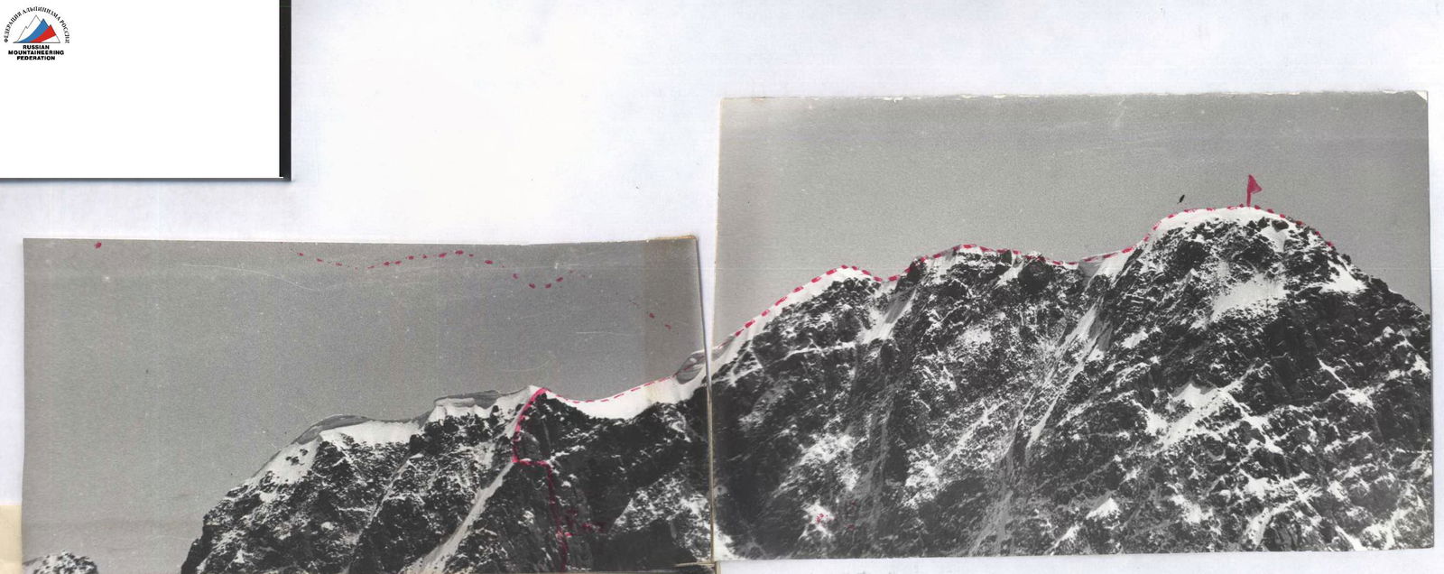
- Climbing route — p. Dzhigit 5170 via the triangle of the northern wall (Sharashanidze).
- Difficulty category — 6B
- Route description:
elevation gain — 110 m (to the ridge) average steepness — 68° average steepness of the complex section — 85° length of the complex section (length of the section with 5–6 cat. diff.) — 900 m route length — 1200 m (to the ridge)
-
Pitons hammered: rock — 196 + 9 ITO ice — 28 + 3 ITO
-
Number of climbing hours — 47
-
Number of nights and their characteristics: 1 — hanging, 3 — sitting, 2 — lying.
-
Team composition: Prokopenko Galina Semenovna — CMS, captain; Vodopyanov Sergey Konstantinovich — CMS; Gutin Vladimir Borisovich — CMS; Kaspirovich Grigory Efimovich — MS; Plotnikov Andrey Evgenievich — CMS; Prokopenko Vladimir Ivanovich — MS, coach; Khaneft Alexander Vilievich — CMS.
-
Team coach — Prokopenko Vladimir Ivanovich.
-
Dates of departure and return: July 17, 1980 July 23, 1980
Climbing Description
(Brief explanation for the table)
July 17, 1980. The trio of Gutin, Khaneft, and Plotnikov worked ahead.
Section R0–R1
Ice crevasse crossing the entire slope, leading to the upper cirque of the icefall. At the narrowest point (10 m), ascent via vertical and overhanging ice using anchor hammers and ice axe on twelve-tooth crampons. Piton belay. Two ladders.
Section R1–R2
Snow slope under the bergschrund.
Section R2–R3
Bergschrund is not complicated. One ladder.
Section R3–R4
Steep ice slope towards the rock islands and through them under the rocks of the first control point (landmark — rope). The first person goes with anchor tools.
Section R4–R5
Difficult traverse to the right across steep ice and snow-covered rocks into the couloir.
Section R5–R6
Steep couloir with loose rocks. Movement one by one. The next person goes under the overhanging slabs on the traverse.
Section R6–R7
Rocks resembling "sheep's foreheads". Passage hindered by fresh snow. Cold in galoshes, slippery in vibram soles, unreliable in crampons.
Section R7–R8
Traverse to the right under an overhang.
Section R8–R9
Smoothed slabs with few handholds. Lower point for pulling up backpacks.
Section R9–R11
Difficult ice-filled internal corner. Above it, a ledge. Point for pulling up backpacks.
Section R11–R12
Overhanging wall. Passed by free climbing and with ladders. Backpacks are pulled up.
Section R12–R13
Inclined slab under a cornice. Second control point in a "bank". On the cornice, an empty gasoline can is hung (landmark). Two pitons hammered. Organization of the night: sitting on suspended backpacks, covered with a tent. Food is prepared on knees (primus stove).
July 18, 1980.
Section R13–R16
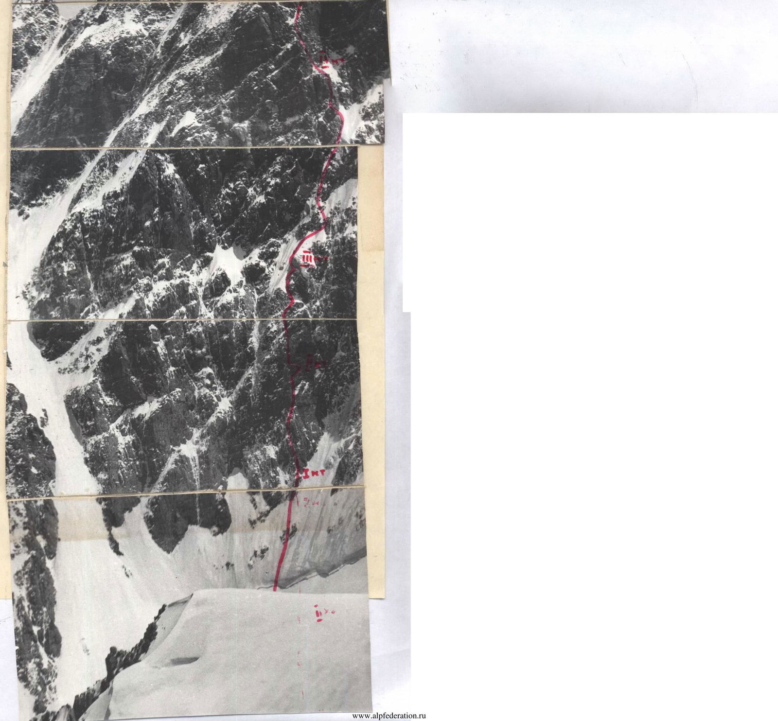
One of the most difficult sections on this wall. Few handholds, great steepness, and cold. Gutin leads. The section ends with an exit onto the "roof" of the cornice — the edge of the wall.
Section R16–R21
Very difficult climbing. Optimism is inspired by occasionally encountered "carrots" hammered into rock cracks. Exit onto a ridge leading to a white rock. Plotnikov leads.
Section R21–R22
Steep rock ridge with vertical walls. Very bad weather, damp and cold. We exit under the white rock and dig out sitting platforms in the steep ice slope. Ice depth is insufficient to dig out more comfortable platforms.
July 19, 1980, and July 20, 1980. Waiting out bad weather. Sections R22–R24 processed.
July 21, 1980.
Section R22–R23
Across steep "sheep's foreheads" under the white rock. Here, on a piton in a "bank", is the 3rd control point. Bypass the rock via firm natty ice with a steepness of 60°. Gutin leads.
Section R23–R24
- Long ice slope with frequent rock outcrops.
- Movement under an overhanging rock wall and further along it.
- Here, on the rocks, we found a left-behind safety harness.
- Kaspirovich leads.
Section R24–R25
At the point where the edge of the ice slope starts to veer left, we move under a steep wall with a cornice via convenient rocks.
Section R25–R26
The wall is climbed head-on; the cornice on the right has a diagonal crack. Artificial climbing. Khaneft leads.
Section R26–R27
Ledge with scree. On it, two platforms are skillfully arranged, reinforced with a rope. One can sleep lying down!
July 22, 1980.
Section R27–R28
- In the left corner of the ledge is the 4th control point.
- Directly through it, up the wall to the "sheep's foreheads".
Section R28–R29
Across "sheep's foreheads" to the right and upwards under the sheer triangle of the last wall before exiting onto the ridge.
Section R29–R30
- Sheer wall, местами встречаются нависания.
- To the left, massive rock cornices.
- Climbing is difficult with the use of ITO.
- On a small ledge is the 5th control point.
Section R30–R31
Rock wall leads under the ridge. Falling snow complicates the group's progress.
Section R31–R32
- Across an inclined ledge with snow, traverse onto the ridge.
Section R32–R33
- Ridge heavily covered in snow.
- Short sheer walls encountered.
- Ridge leads to the main ridge of p. Dzhigit.
Section R33–R34
- Long ridge with powerful snow cornices overhanging on both sides.
- Belay via ice axes.
- Ridge leads to the summit.

| Date, designation | Approx. steepness, ° | Length, m | Terrain characteristics | Difficulty | Condition | Weather conditions | Rock pitons | Ice pitons |
|---|---|---|---|---|---|---|---|---|
| 1 | 2 | 3 | 4 | 5 | 6 | 7 | 8 | 9 |
| 07.07.80 | ||||||||
| R0–R1 | 90° | 10 | ice crevasse | 5 | firm ice | overcast | - | 3 + 2 |
| R1–R2 | 20° | 160 | snow slope | 2 | loose snow, compacted | overcast | - | - |
| R2–R3 | 90° | 2 | bergschrund | 4 | firm ice | - | - | 2 + 1 |
| R3–R4 | 50° | 120 | ice slope | 5 | ice covered with snow | - | - | 12 |
| R4–R5 | 60° | 5 | rock traverse | 5 | snow-covered rocks | - | - | - |
| R5–R6 | 70° | 20 | couloir | 5 | snow-covered rocks | - | - | - |
| first control point | ||||||||
| R6–R7 | 50° | 40 | snow-ice wall | 4 | covered with fresh snow | - | 3 | 1 |
| R7–R8 | 80° | 6 | traverse right under overhang | 5 | covered with fresh snow | snowfall | 2 | - |
| R8–R9 | 80° | 80 | slabs | 5 | icy slabs | snowfall | 12 | - |
| R9–R10 | 90° | 5 | internal corner | 4 | icy relief | - | 3 | - |
| R10–R11 | 50° | 2 | ledge | snow-covered | - | 2 | - | |
| R11–R12 | 110° | 10 | wall with overhang | 6 | wet rocks | - | 5 + 2 | - |
| R12–R13 | 30° | 8 | ledge and inclined slab with a crack | snow-covered | - | 5 | - | |
| second control point | ||||||||
| Departure at 7:00. Stop at 21:00. 14 climbing hours. Hanging night. | ||||||||
| 08.07.80 | ||||||||
| R13–R14 | 90° | 8 | bypassing a cornice | 5 | icy rocks | overcast | 3 | - |
| R14–R15 | 90° | 12 | traverse above a cornice | 6 | — " — | - | 2 | - |
| R15–R16 | 100° | 10 | exit onto the edge | 6 | dry rocks | good | 4 | - |
| R16–R17 | 100° | 10 | internal corner | 6 | — " — | - | 3 + 3 | - |
| R17–R18 | 90–100° | 40 | chimney | 6 | — " — | - | 12 | - |
| R18–R19 | 90° | 5 | bypassing a cornice | 6 | — " — | overcast | 2 | - |
| R20–R21 | 60° | 120 | exit onto a ridge | 4–5 | snow-covered rocks | snow | 18 | - |
| Departure at 8:00. Stop at 19:00. 11 climbing hours. Sitting night. | ||||||||
| 19.07.80–20.07.80. Waiting out bad weather. Snowfall. Thunderstorm. Dust avalanches. | ||||||||
| 21.07.80 | ||||||||
| R21–R22 | 70° | 40 | "sheep's foreheads" | 4 | snow-covered | good | 8 | - |
| R22–R23 | 60° | 40 | ice, bypassing a white rock | 5 | ||||
| "tent" | firm natty ice | very cold | - | 5 | ||||
| R23–R24 | 55° | 240 | ice slope | 5 | thin layer of snow | - | - | - |
| R24–R25 | 60° | 40 | rock wall | 4 | rock outcrops | good | 28 | 5 |
| R25–R26 | 90–100° | 40 | wall with a cornice | 6 | dry rocks | good, cold | 10 + 3 | - |
| R26–R27 | 20° | 20 | ledge with scree | 3 | snow, ice, scree | good | 10 + 3 | - |
| fourth control point | ||||||||
| Departure at 9:00. Stop at 18:00. 9 climbing hours. Lying night. | ||||||||
| 22.07.80 | ||||||||
| R27–R28 | 90° | 40 | chimney | 5 | dry rocks | overcast | 8 | - |
| R28–R29 | 70° | 40 | "sheep's foreheads" | 4 | snow-covered | - | 5 | - |
| R29–R30 | 90° | 80 | wall | 5–6 | wet rocks | snow | 24 + 2 | - |
| fifth control point | ||||||||
| R30–R31 | 90° | 40 | wall | 5 | wet rocks | - | 10 | - |
| R31–R32 | 70° | 40 | traverse onto a ledge | 4 | snow-covered | - | 8 | - |
| R32–R33 | 60° | 100 | steep buttress | 4–5 | snow-covered rocks | - | 16 | - |
| Departure at 8:00. Stop at 18:00. 10 climbing hours. Lying night. | ||||||||
| Exit onto the ridge of the summit. | ||||||||
| 23.07.80 | ||||||||
| R33–R34 | 15–30° | 400 | snow ridge | 3–4 | snow compacted | good | ice axe | 8 |
| Departure at 7:00. Summit at 10:00. 3 climbing hours. Descent to the storm camp at 17:00. | ||||||||
| Total: 47 climbing hours. | 196 + 9 | 28 + 3 | ||||||
| ITO | ITO |


