ASCENT REPORT
-
Region, valley, classification table section number (2001):
Tian-Shan, Terskey Ala-Too, 7.10.44a
-
Peak name, route name:
Dzhigit, via the center of the North face
-
Climbing category: 6A
-
Route type: combined
-
Route elevation gain: 1220 m (by altimeter)
Route length: 1355 m. Length of sections: V category: 820 m, VI category: 370 m. Average steepness:
- main part of the route: 78°
- entire route: 68°
-
Number of pitons used on the route: rock: 112 pcs., chocks: 91 pcs., ice screws: 27 pcs., stationary bolts: 32 pcs., incl. artificial aids: 4 pcs. Pitons left on the route: 2 pcs.
-
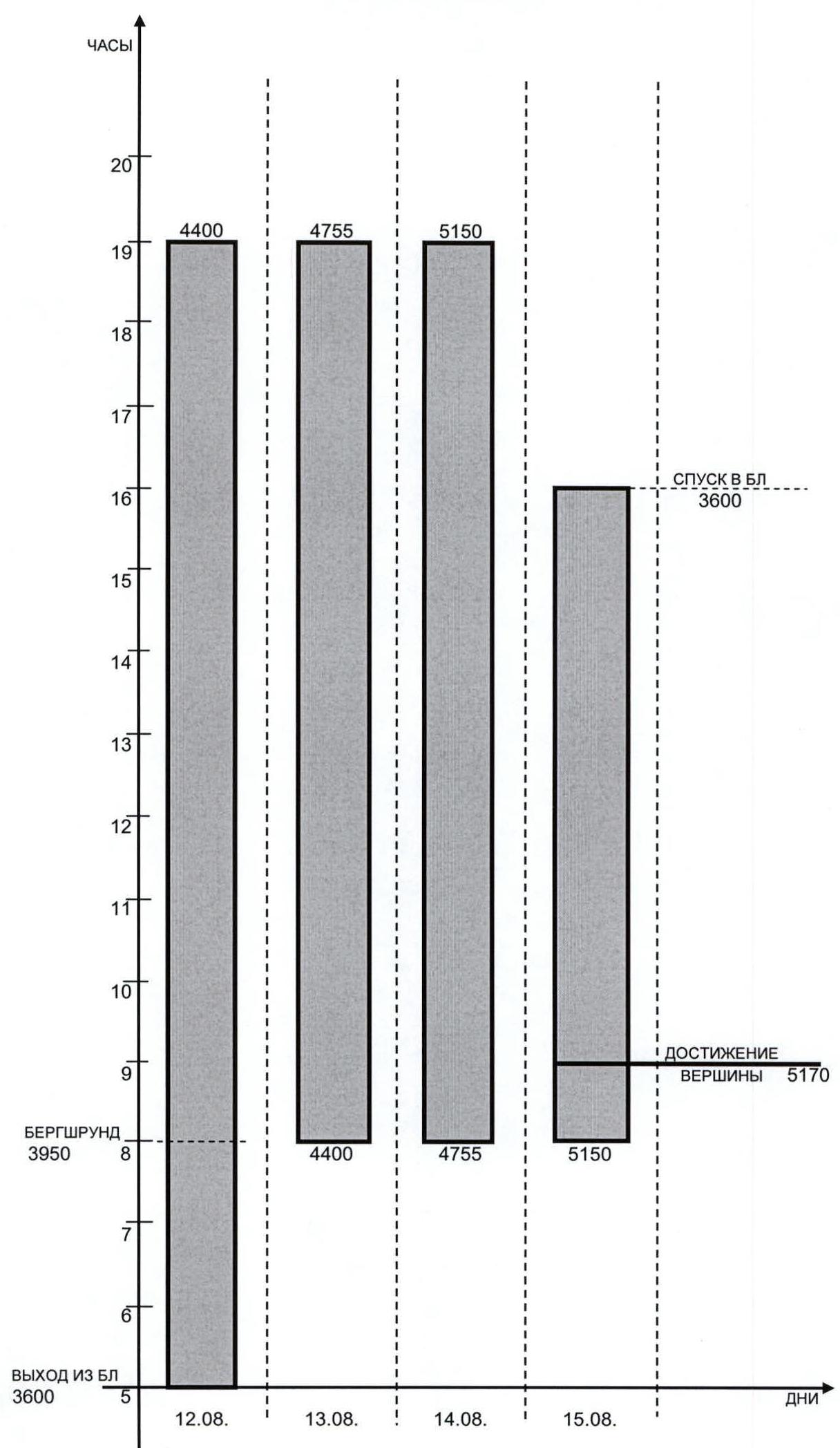
Team's total climbing hours: 37 h, days: 3.5
-
Team leader: Evgeny Vinnikov, Candidate for Master of Sports (ine@csys.ru)
Team member: Sergey Khlimonok, 1st sports category, born 1981
-
Coach: Vladimir Tumyalis, Master of Sports
-
Approach to the route: 5:00, August 12, 2006
Summit reached: 9:00, August 15, 2006. Return to Base Camp: 16:00, August 15, 2006
-
Organization: Tomsk Federation of Alpinism
GENERAL PHOTO OF THE PEAK
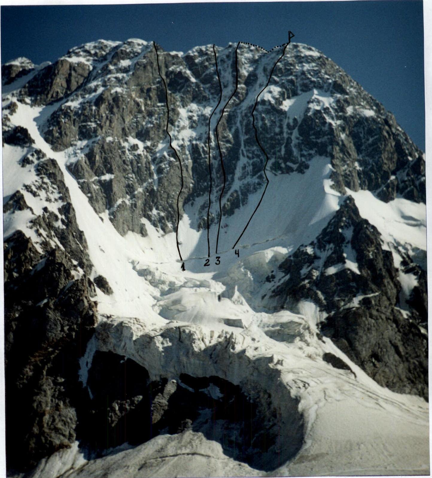
Photo 1. Taken on August 10, 2006, at 17:00 from Base Camp under Dzhigit peak.
- D. Sharashenidze route, 6A category
- V. Vakurin route, 6A category
- I. Slesov route, 6A category
- A. Ryabukhin route, 6A category
AREA MAP
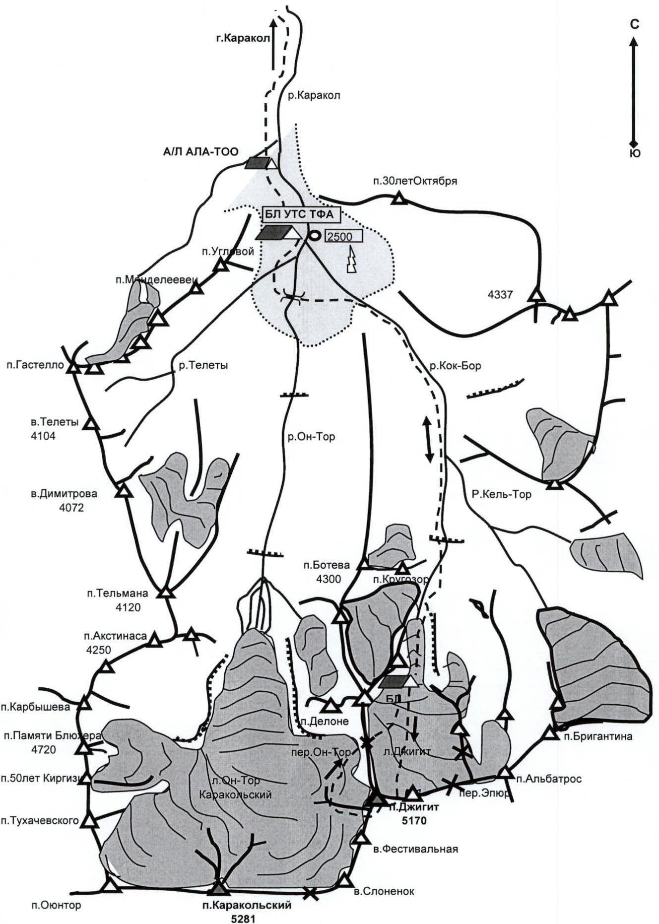
CHARACTERISTICS OF THE AREA AND THE CLIMBING OBJECT
The Terskey Ala-Too ridge is located in the Central Tian-Shan, on the territory of Kyrgyzstan. Terskey Ala-Too is one of the most powerful chains of Tian-Shan and stretches for approximately 400 km. The ridge bounds Lake Issyk-Kul from the south with steep Northern slopes. As the ridge stretches roughly in the latitudinal direction and stands as a powerful barrier on the path of SW and N winds, its highest part condenses moisture evaporated from the surface of Lake Issyk-Kul. As a result, the weather in the area is unstable, and precipitation occurs periodically. Dzhigit peak (5170 m), the second highest peak in the Terskey Ala-Too ridge, is located 9 km east of Karakolsky peak (5281 m), approximately 50 km south of the city of Karakol (Przhevalsk), in the upper reaches of the right tributary of the Karakol river (Kok-Bor tract). From Karakol city, a car can drive 25-30 km up the Karakol valley to the "Ala-Too" alpine camp and the confluence of Kok-Bor and On-Tor rivers. Further along the right bank (orographically) of the Kok-Bor river, loads can be transported on horses, almost to the "tongue" of the Dzhigit glacier, - the approach takes about 5-6 hours. From under the glacier to the camps under Dzhigit peak, the approach takes 1.5-2 hours. Like most surrounding peaks, Dzhigit peak is composed of granites, which are enriched in many places with:
- quartz,
- feldspar.
To the NE, N, and NW, Dzhigit peak drops with walls. Moreover:
- NE and NW walls have a semblance of a steep counterfort,
- the center of the North wall is a pronounced wall in the direct sense of the word.
The rocks are composed of large blocks, with many internal angles, chimneys, and slabs, filled with ice and powdered with snow. The ice has a very characteristic structure: hard, brittle, and porous. During the observation period, it was noted that, unlike the routes of D. Sharashenidze and V. Vakurin (frequent rockfall throughout the day), the convexity of the center of the North wall makes I. Slesov's route relatively safe. For this reason, I. Slesov's route was chosen for the ascent.
TECHNICAL PHOTOGRAPHY OF THE ROUTE

ROUTE SCHEME IN UIAA SYMBOLS
| rock (incl. artificial aids) | chocks (incl. artificial aids) | bolts (incl. artificial aids) | ice screws | Description of section | Section |
|---|---|---|---|---|---|
| 4 | 4 | - | - | 5+, A3, 30 m, 75° | R8 |
| 12 | 5/2 | 4/2 | - | 6, A4e, T, 60 m, 90° | R7 |
| 3 | 4/2 | - | - | belay point № 1 6, A3e, 30 m, 80° | R6 |
| 2 | 2 | 1 | 1 | 5+, A3e, T, 20 m, 75° | R5 |
| 6/1 | 6/2 | 3/1 | - | 6, A3e, T, 40 m, 95° | R4 |
| 10 | 6 | 2 | - | 5+, A3e, T, 130 m, 75° | R3 |
| - | 2 | 5 | - | 5+, 40 m, 80° | R2 |
| - | - | 14 | - | 5+, 150 m, 65° | R1 |
| - | - | - | 1 | 5+, 5 m, 95° | R0 |
| 8/2 | 6/4 | 2 | - | 6, A4e, T, 50 m, 95° | R15 |
| 6 | 6/1 | 3 | - | 5+, A3e, T, 70 m, 80° | R14 |
| 8/1 | 4 | 3 | - | 6, A3e, T, 40 m, 90° | R13 |
| 2 | 2 | 2 | - | belay point № 3 5+, A3e, T, 15 m, 75° | R12 |
| 6 | 12 | 2 | - | 5+, A2, T, 200 m, 70° | R11 |
| 14/3 | 8/3 | 2 | - | belay point № 2 6, A4e, T, 60 m, 95° | R10 |
| 6 | 4/2 | 2 | - | 6, A3e, T, 50 m, 80° | R9 |
| - | - | 2 | - | 4-, 150 m | R22 |
| - | - | 2 | - | belay point № 5 4+, 15 m, 60° | R21 |
| 4 | 5 | 1 | - | 5+, T, 30 m, 85° | R20 |
| - | - | - | - | 5+, 60 m, 75° | R19 |
| 1 | 3 | - | - | 5-, 20 m, 65° | R18 |
| 5 | 7/1 | 4 | - | 6, A3e, T, 40 m, 90° | R17 |
| 6 | 3 | - | - | belay point № 4 5+, 50 m, 80° | R16 |
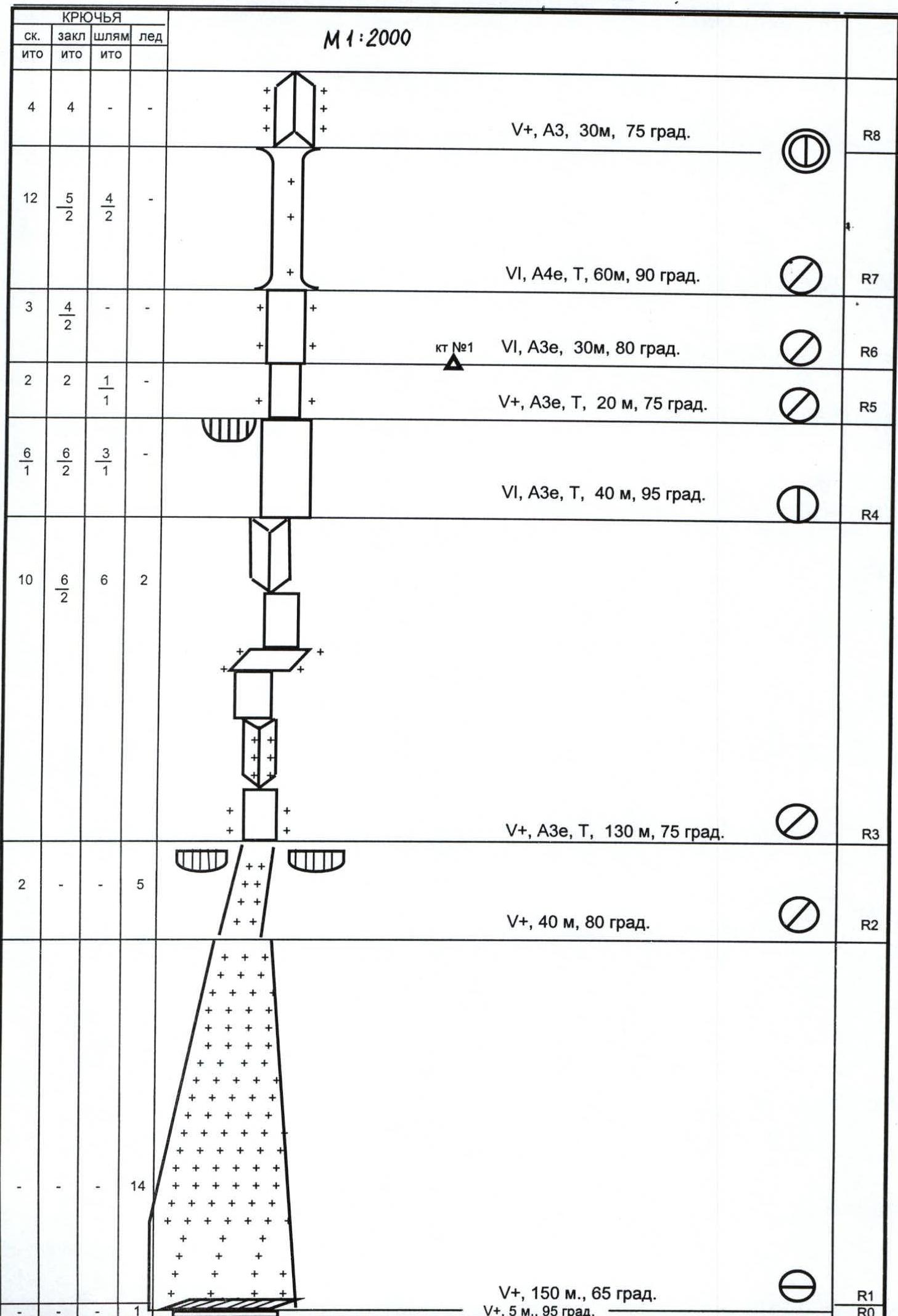
PHOTO ILLUSTRATIONS OF THE REPORT
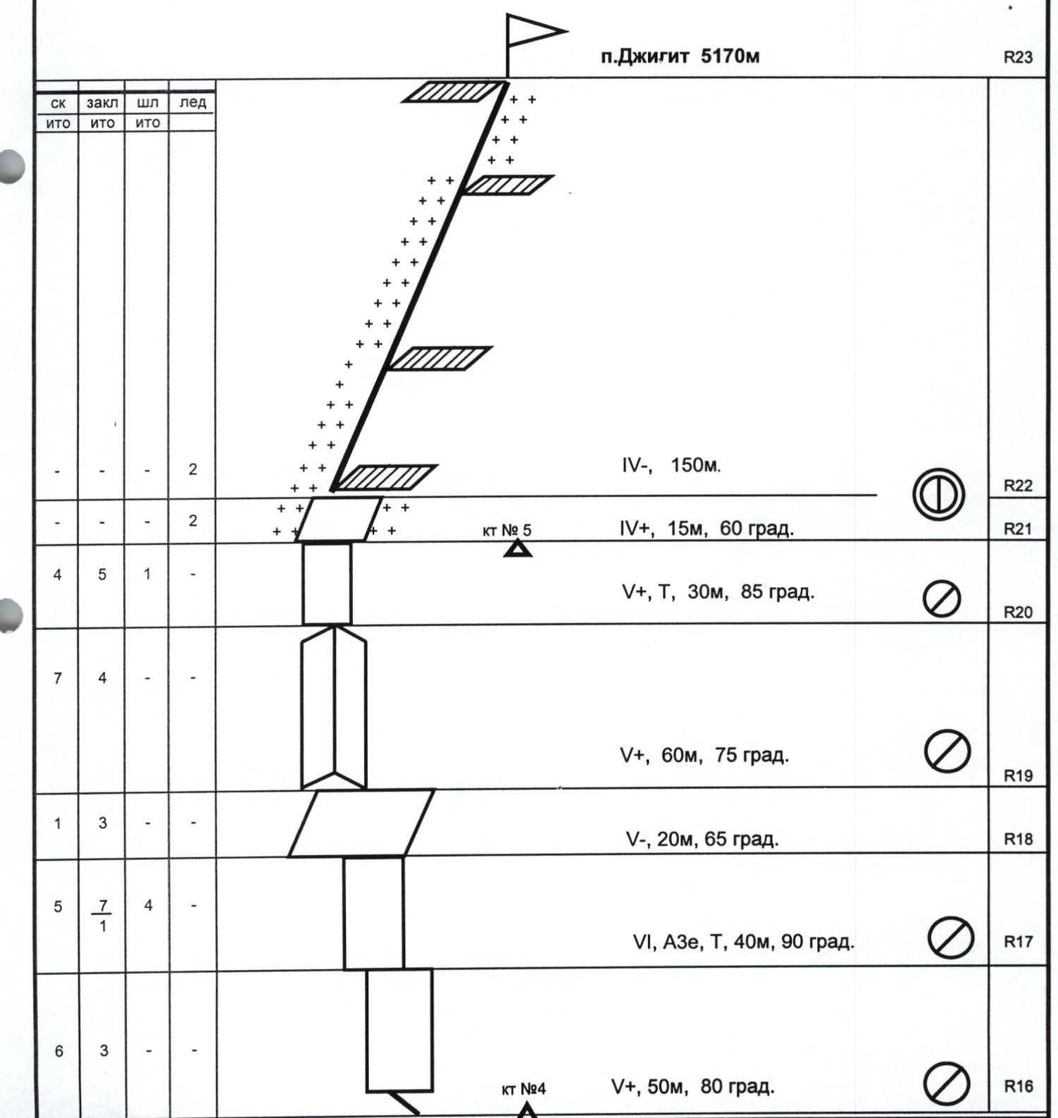
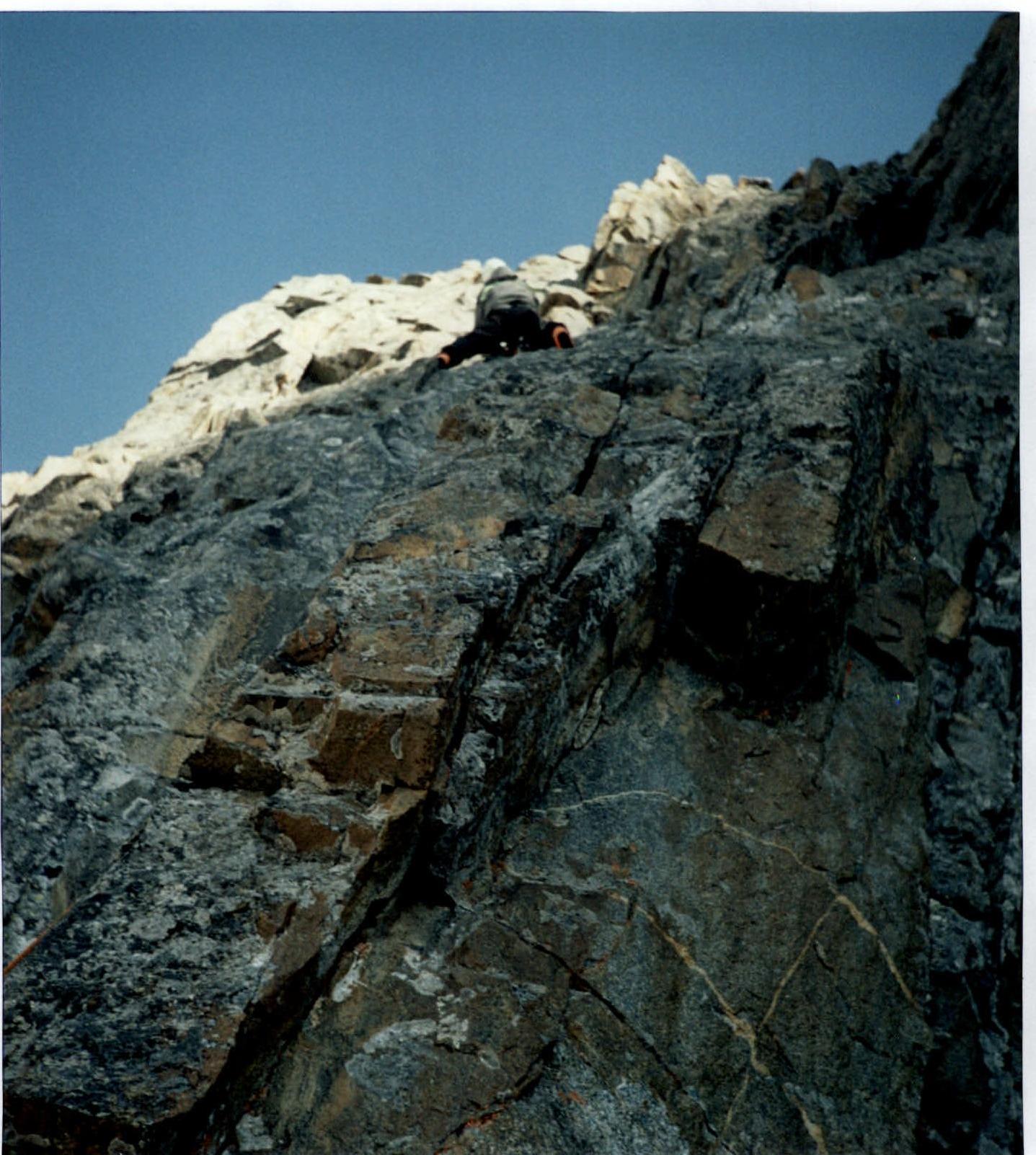
Photo 1. On the rock wall, 80°, after belay point № 1. Section R6-R7, August 12, 2006.
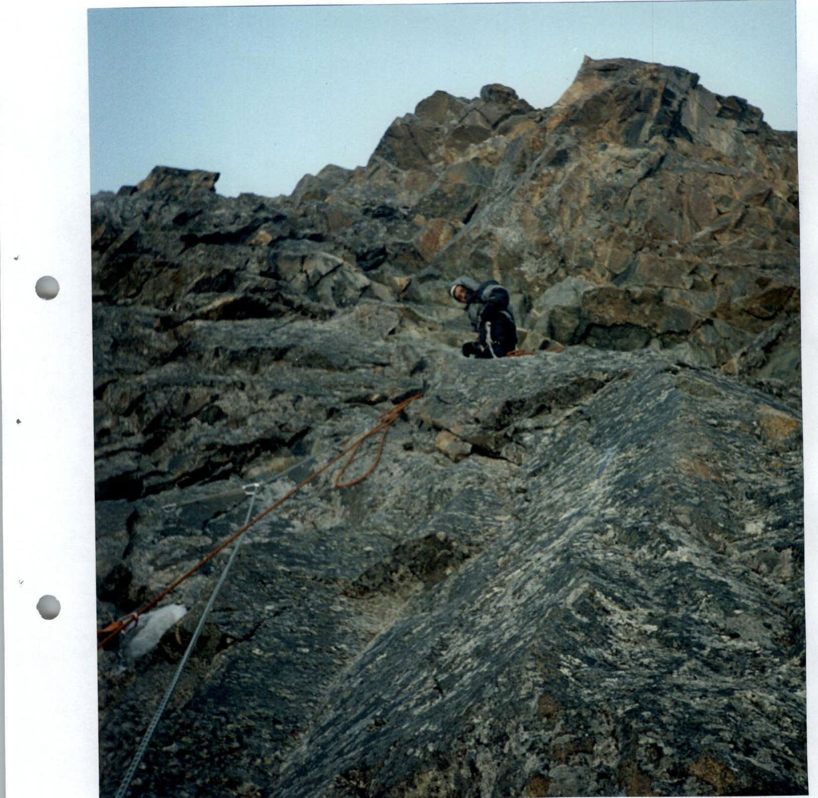
Photo 3. On the rock wall under the "red rocks" near belay point № 2. Section R10-R11, August 13, 2006.


