Report
on the ascent to Jigit Peak (5170 m) via the north face, made on August 13-20, 1965, by the Chelyabinsk Region team competing in the USSR championship in the category of high-altitude technical routes.
Jigit Peak (5170 m) is located in the axial part of the Terskey-Alatoo ridge and closes the Kokbor valley, 60 km south of Przhevalsk town. The Kokbor River is a right tributary of the Karakolka River. A truck can reach the 19 km mark along the Karakol valley. Further on, for 21 km, there is a good horse trail. The last 11-12 km to the tongue of the Jigit Glacier are shepherd's trails. Loads are relayed from the end of the motorable road.
Jigit Peak is the second-highest peak in the ridge; the main peak, Karakolsky Peak (5281 m), is located approximately 8-9 km to the west (see the orographic scheme, Fig. 1).
Jigit Peak, like all surrounding peaks, is composed of granites, which in many places are enriched with spars. It drops to the north with a wall, against which two buttresses, the northern and northeastern, rest, the latter being bifurcated in the lower part. The northern buttress merges with the wall at a height of approximately 4370 m.
Jigit Peak was climbed twice: in 1939, a group led by V.I. Ratsek made the first ascent via the eastern ridge; in 1957, a group of instructors from the "Metallurg" alpine camp (Talgar) led by M.P. Menyailov traversed from Karakolsky Peak to Jigit Peak (descending via the route of the first ascenders). No attempts to climb via other routes had been made until then. Any route to the summit of Jigit Peak is of sporting interest.
As a result of our reconnaissance and observations of the north face in 1953, 1954, 1956, 1957, 1959, and 1962, it became clear that the most logical and safe route, although technically very challenging, is the ascent via the northern buttress and then directly up the north face to the summit. The average steepness of the entire route is 67°, with a height difference of 1640 m (3530 - 5170 m).
The route is combined: ice-covered rocks (rarely pure) alternate with snow and ice sections of significant steepness.
The summit is located at 42° north latitude, and the route is sunlit only in the morning (6:00 to 8:00) and evening (17:00 to 19:00) hours. The Terskey-Alatoo ridge stretches almost latitudinally and stands as a mighty barrier to southwestern winds, directing them towards the Khan-Tengri - Pobeda regions. Naturally, partial condensation of vapors occurs in its highest part, i.e., in the area of Jigit Peak. In the same area, moisture condenses from the vast surface of Lake Issyk-Kul, i.e., coming from the north. Precipitation often has a pronounced periodic character: daily (very rarely excepted) from 12:00 to 20:00. Prolonged bad weather (3-4 or more days) often coincides with a change in the lunar phase. Overall, the meteorological conditions in the area are harsh.
To clarify the route and its condition this year, ascents were made to nearby peaks.
-
A group consisting of:
- V. Samokhvalov,
- A. Ryabukhin,
- V. Makovetsky,
- V. Osipov
made a first traverse of Briganтина - Albatross (August 3-7) and viewed the route to Jigit Peak in profile from the east and the eastern ridge (the path of the first ascenders).
-
A group consisting of O. Trubnikova and N. Levchenko climbed to Krogzor Peak - 2B category of difficulty (August 2) and viewed the route in semi-profile from the east.
-
A group consisting of A. Ryabukhin and O. Trubnikova (August 9), while passing through a pass under Jigit Peak from the Kokbor valley to the Oyuntyor valley, viewed the route in profile from the west, as well as the western ridge, and outlined a possible descent route from the saddle between Jigit Peak and Festivalnaya Peak to the north, estimating it approximately as 4B category of difficulty.
-
For four days (August 9-12) before the ascent, the group stayed under the route (Observers' Camp - 3530 m), continuously observing it.
Preparations for the ascent to Jigit Peak via the north face began in 1956. These long years were spent forming and training a team capable of confidently tackling the challenging route, developing, researching, and testing various specialized mountaineering equipment. The training camps in Bezengi, held in 1961, 1963, and 1964, played a significant role in team formation.
Since 1960, the group has been using non-standard mountaineering equipment manufactured in-house, including:
- Ice screws made from D16AT and V-95 alloys with a conical thread on the body, a steel head (on a threaded pin with a cotter pin), and titanium eyes.
- Universal rock pitons of various thicknesses and sizes made from titanium alloys and D19AT.
- Carabiners of the standard type made from V-95 alloy.
- Rope carabiners made from nylon (6 mm diameter cord).
- Reusable pitons with a threaded tightening mechanism, 12 mm diameter (titanium body, steel wedge, titanium eye).
Annual tests of the equipment are conducted in the research laboratory of the Strength of Materials Department at Chelyabinsk Polytechnic Institute under the guidance of Associate Professor D.A. Gokhfeld, Chairman of the Strength Committee of the Scientific and Technical Society of the Machine-Building Industry.
Many members of the CPSI alpine section, who are research scientists, participate in the manufacture and research of equipment.
The equipment was tested by participants on 14 routes of the 5th category of difficulty. As a result, changes were made to the designs. For example:
- Carabiners had their cylindrical coupling replaced with a hexagonal one, allowing them to be used without removing gloves, which is crucial on "cold" routes.
- The pitch of the ice screw thread was changed, improving their removal from ice, and so on.
To better prepare for the route, regular winter training was introduced on snowy and icy rocks and running on deep, loose snow.
The organizational plan was as follows:
- The assault group, consisting of A. Ryabukhin, V. Samokhvalov, O. Trubnikova, V. Makovetsky, N. Levchenko, V. Osipov, and the support group, consisting of V.V. Mokshantsev (quartermaster), V.I. Smirnov, E. Utrivanova, V. Shchekunov, conducted training camps in the Talgar alpine camp from July 10 to 29.
- On July 10, a group consisting of Yu.N. Sychev, V.M. Denisov, P.F. Greilikh, V.N. Grafov, L.S. Mokshantseva, G.R. Rung, V. Khudozhin, G.F. Sidorov, led by V.A. Reznikov (a participant and, in recent years, the leader of expeditions to this area in 1954, 1957, 1959, 1963, and 1964), traveled to the Karakol valley, conducted reconnaissance, set up the "Green" camp (2800 m, at the confluence of the Oyuntyor and Kokbor rivers, in the forest), and obtained horses for the caravan.
- July 31 - August 1: All participants gathered at the end of the motorable road (Ratsek's parking lot).
- Two groups (Samokhvalov's and Trubnikova's) departed for Jigit Peak to make ascents to peaks 4850 m (Briganтина) and 4800 m (Albatross) in coordination. The remaining participants, led by V.V. Mokshantsev, transported loads to the "Green" camp and then made ascents in the Auyuntyor valley according to the plan.
- August 6-8: All participants gathered at the "Green" camp and departed to set up the Observers' Camp (3530 m) on the left-bank lateral moraine of the Jigit Glacier, to stock up on food and equipment for the assault group and observation groups. The assault group made one load-carrying trip and then observed the route and made reconnaissance trips, and if necessary, ascents.
- After setting up the Observers' Camp, the support groups made their ascents before the assault group started the route.
- Ascent to Jigit Peak.
- Evacuation of loads to the beginning of the motorable road and then by car to Alma-Ata.
This plan was fully implemented. For training and acclimatization ascents, the assault group chose Ak-Tau Peak (4720 m) and Gl. Talgar (5017 m) via the western wall (3B and 5B categories of difficulty, respectively).
The ascent to Gl. Talgar took place in poor weather conditions, which once again tested the group's readiness to work on the route in challenging meteorological conditions, typical for the Jigit Peak area.
The expedition's doctor, also a graduate of the CPSI alpine section, second-category climber G.R. Rung (doctor at the Chelyabinsk City Physical Education Dispensary), conducted constant systematic observations of the participants - both in the mountains and in the city, adjusting the training loads and the nature of the training. This allowed the participants to perform a significant amount of work without strain or fatigue.
After completing all reconnaissance, a final tactical plan for the ascent was developed:
a) Pass the lower section of the route to the base of the second wall as quickly as possible; b) Process the second wall (likely taking a whole day), as it cannot be passed in one day, and it is desirable to have only one uncomfortable bivouac on it (likely somewhere in the middle part of the large ice gully); c) After the uncomfortable bivouac, have a good rest (a comfortable bivouac in the area of the second ice belt); d) Pass the third wall in one day, as there are no places for a comfortable tent bivouac on it, while under the summit (fourth) wall, there is a snow and ice ridge (the third ice belt); e) Take three ropes (2×40 m and 1×60 m) and three ladders (1×10 m and 2×1.5 m) on the route; f) On snow and ice sections - Samokhvalov - Makovetsky, on rock sections - Ryabukhin - Trubnikova; g) Maximally unload the leading rope team where possible to walk with a backpack; h) Descend via the western ridge to the saddle with Festivalnaya Peak and then north to the glacier under Karakolsky Peak (the easiest route psychologically and technically); i) Escape routes: down the route taken (leave pitons in the most difficult places); in the lower part of the route, follow the rocky islands in the eastern part of the first wall.
The route differs from the one declared in the application only in its lower part. The application had envisaged an ascent via the rocks of the first wall (average steepness 55-60°). After a detailed study of the route, it became clear that this section, not having significant technical difficulties, would take a lot of time, as it would have to be traversed slowly: in the middle part, the rocks are heavily destroyed (incidentally, this is the only rockfall-prone section on the entire route). It was decided to bypass the first wall from the east: through the icefall of the cirque glacier and then up a steep ice slope to reach the ridge of the buttress above the first wall. Technically, this bypass is much more challenging than the first wall, but it is significantly safer. Moreover, the team had passed a similar route - the northern ice wall of Ullu-Auz (5B category of difficulty) - as training in 1964 and felt confident on snow and ice (any participant could be the lead).
The original composition of the assault group was as follows:
core team:
- Ryabukhin A.G. - team captain
- Samokhvalov V.V. - deputy team captain
- Trubnikova O.I.
- Makovetsky V.A.
- Osipov V.P.
- Samigulin R.R.
- Kolmakov A.I.
reserve team: 8. Levchenko N.I. 9. Pavlov Yu.N.
However, Yu.N. Pavlov and A.I. Kolmakov were unable to take part in the expedition due to work commitments.
R.R. Samigulin, invited from the town of Votkinsk, a CPSI graduate, died during an ascent to Karakulchi-Tau Peak in a group of Alma-Ata climbers a month before the start of the expedition.
In light of this, it was decided to proceed with the following composition:
- Ryabukhin A.G.
- Samokhvalov V.V.
- Trubnikova O.I.
- Makovetsky V.A.
First-category climbers V.P. Osipov and N.I. Levchenko led the rescue team of the expedition.
Team captain A.G. Ryabukhin is the coach of Samokhvalov and Makovetsky from their beginner days, and of Trubnikova since 1963. Naturally, each participant knows their duties in the group, and through numerous joint ascents, all frictions and rough edges have been smoothed out. Currently, the team represents a friendly family united by common aspirations in sports and common interests at work. During the ascent, all participants worked well together, in harmony, and with confidence.
The support team consisted of the rest of the expedition members:
first-category climbers - N.I. Levchenko, V.P. Osipov, L.S. Mokshantseva.
second-category climbers -
- V.N. Grafov
- P.F. Greilikh
- V.M. Denisov
- V.V. Mokshantsev
- V.A. Reznikov
- G.R. Rung (doctor)
- G.F. Sidorov
- V.I. Smirnov
- Yu.N. Sychev
During the assault on Jigit Peak's wall, the support groups, in addition to observing from the camp, monitored the ascent with binoculars and maintained rocket and sound communication with our group, making ascents to nearby peaks (there were always at least six people in the camp, including a doctor).
The support groups made the following ascents (see the orographic scheme of the area):
- August 13, 1965 — Peak I.E. Tamm (2B category of difficulty): L.S. Mokshantseva, V.N. Grafov; camp - the remaining 13 people.
- August 14 — camp - all 15 people.
- August 15 — Peak Kh. Boteva (2B): V.A. Reznikov, V.I. Smirnov, V. Khudozhin, E. Utrivanov; camp - the remaining 11 people.
- August 16 — Peak Kh. Boteva (2B): V. Shchekunov, G.F. Sidorov; camp - the remaining 13 people.
- August 17 — Peak Albatross (5A category of difficulty): V.P. Osipov, V.N. Grafov, P.F. Greilikh, Yu.N. Sychev, V.M. Denisov, L.S. Mokshantseva; camp - the remaining 9 people.
- August 18 — Peak I.E. Tamm (2B): V. Khudozhin, V.I. Smirnov. Peak B.N. Delone (4A category of difficulty): L.S. Mokshantseva, V.V. Mokshantsev; camp - the remaining 11 people.
- August 19 — Peak B.N. Delone (3A): V. Khudozhin, V.I. Smirnov; camp - the remaining 13 people.
- August 20 — camp - all participants.
The assault group members had collectively completed 21 different routes of the 5th category of difficulty. Among them were routes such as the northern edge of Mizhirgi, the northern edge of Shkhara, the northern wall of Ullu-Auz, the northwestern and western walls of Talgar, the northern wall of Ullu-Tau, Shchurovsky, Shkhelda, Koshtan-Tau, and others. However, none of them had passed a route like this before. The exceptional technical saturation of the route, significant psychological load, and constantly challenging meteorological conditions in this area led to the classification of the route as 6B category of difficulty.
On August 13 at 3:45, the group departed from the camp on the left-bank lateral moraine of the Jigit Glacier (Observers' Camp - 3550 m). See Fig. 1. We cross the closed glacier to the right and upwards, cut by radial crevasses, approach the ascent into the cirque between the northeastern and northern buttresses. We ascend via the tongue of the cirque glacier (section R1) to the ice ledges (R2). Fig. 2 and 3.
Section R1 is first passed by the Samokhvalov - Makovetsky rope team. The first ledge is bypassed on the right, then we traverse left and bypass the second ledge. We cross crevasses behind the second ledge via snow bridges. The third ledge is bypassed on the left via a crevice filled with 1.5-2 m deep loose snow. At the top of the ledge, we cross three crevasses 1.5-3 m wide via fragile bridges.
Section R2 is first passed by the Ryabukhin - Trubnikova rope team. The fourth ledge is bypassed on the left, and we move over it to the right and upwards via loose deep snow to the subglacial crevasse (R3). The Samokhvalov - Makovetsky rope team leads first. The exit to the ridge of the buttress is oriented by the right edge of the cornice on the ridge.
Above the subglacial crevasse:
- 40 m of natty ice (Samokhvalov - Makovetsky)
- The remaining section to the ridge - porous ice (Ryabukhin - Trubnikova)
On the ridge above the first wall, on rocks, the first control cairn is built (end of R4). The ridge ascends in three rises of increasing steepness. The cornice between the first and second rises does not present difficulties for passage. The first two rises are passed by Samokhvalov - Makovetsky.
A place for a tent is hewn at the beginning of the third rise (4330 m). Fig. 5 and 6.
August 14 - a day for processing the lower part of the second wall (Ryabukhin - Trubnikova).
Fig. 7 and 8. Along the ice ridge to the overhanging part of the base of the wall (R6).
To the right and upwards, an ice gully (R7) ascends.
Fig. 9. After 20 m, the gully turns directly upwards.
Fig. 10. From the gully, we exit to the right onto slabs (R8).
We ascend the slabs to the base of the overhanging wall with a characteristic yellow transverse stripe. Having hung ropes, the pair descended for the night.
August 15. The group passed the processed section but returned to the previous bivouac due to severe bad weather.
August 16. The group spent 4 hours ascending and pulling up backpacks on R7 and R8 to the base of the overhanging wall. Fig. 11. Here, two smooth overhanging walls converge, forming an internal angle with a 20° negative inclination, closed from above by a 70-80 cm rock awning (R9). Fig. 13. The wall was climbed using ladders.
Table
Main Characteristics
| № | Average steepness of the section | Height extent | Character of relief | Technical difficulty | Method of overcoming and belay | Weather conditions | Exit from bivouac | Time of stopping at bivouac | Hiking hours | Rock pitons driven | Ice pitons driven | Bivouac conditions | Weight of daily ration |
|---|---|---|---|---|---|---|---|---|---|---|---|---|---|
| R1 | 55° | 200 m | Firn | Easy | Crampons, ice axe | Good | 3:45 | ||||||
| R2 | 60° | 180 m | Ice, snow | Easy and difficult | Crampons, ice axe, pitons | “—” | 5 | 1 | |||||
| R3 | 50° | 80 m | Snow | Easy | Crampons, ice axe | “—” | |||||||
| R4 | 60° | 100 m | Ice | Difficult | Crampons, ice axe, pitons | “—” | 5 | ||||||
| R5 | 55° | 220 m | Snow, ice | Medium difficulty | Crampons, ice axe | “—” | 18:00 | 14:15 | Good, tent | 800 g | |||
| R6 | 60° | 50 m | Ice | Difficult | Crampons, pitons | Strong wind | 8:00 | 4 | 2 | ||||
| R7 | 75° | 40 m | Ice gully | Difficult | Free climbing, cutting steps, pitons | Short snowfalls | 6 | ||||||
| R8 | 80° | 50 m | Slabs, natty ice | Difficult | Free climbing, cutting steps, pitons | Wind, snow, thunderstorm | 5:00 | 18:00 | 10:00 | 12 | 3 | Good, tent | 800 g |
| R9 | Negative 13° | Rocks | Difficult | Pulling up, ladders, pitons | Medium wind, snow | 5:00 | 12 | ||||||
| R10 | 80° | 15 m | Rocks, natty ice | Difficult | Free climbing, pitons | Discharges | 4 | ||||||
| R11 | 75° | 30 m | Slabs, natty ice | Difficult | Free climbing, ledges, pitons | Good, wind | 6 | ||||||
| R12 | 70° | –5 m | Rocks, natty ice | Medium difficulty | Free climbing, ledges | Good | |||||||
| R13 | 75° | 30 m | Ice gully | Difficult | Crampons, pitons, cutting steps | “—” | 21:00 | 16:00 | 3 | 3 | |||
| R14 | 80° | 40 m | Ice gully | Difficult | Crampons, pitons, cutting steps | Good | 6:00 | 2 | 6 | ||||
| R15 | 85° | 25 m | Rocks | Difficult | Free climbing, ladders, pitons | “—” | 6 | ||||||
| R16 | 65° | 40 m | Snow, ice | Medium difficulty | Crampons, pitons, cutting steps | Medium wind, snow | 2 | 4 | |||||
| R17 | 80° | 35 m | Rocks | Medium difficulty | Free climbing, pitons, ledges | “—” | 3 | ||||||
| R18 | 65° | 15 m | Snow | Easy | Steps, ice axe | Good, wind | 17:00 | 11:00 | Good, tent | 800 g | |||
| R19 | 65° | 30 m | Snow, ice | Difficult | Crampons, pitons | Good | 6:00 | 2 | |||||
| R20 | 80° | 40 m | Slabs, natty ice | Difficult | Free climbing, ladders, pitons | “—” | 6 | 1 | |||||
| R21 | 65° | 80 m | Ice | Difficult | Crampons, pitons | “—” | 6 | ||||||
| R22 | 80° | 55 m | Ice gully, rocks | Difficult | Free climbing, pitons, ledges | Medium snow, wind | 8 | 2 | |||||
| R23 | 60° | 10 m | Snow, ice | Difficult | Trench, crampons, pitons | “—” | 2 | ||||||
| R24 | 90° | 15 m | Rocks | Difficult | Free climbing, pitons | Good, wind | 5 | ||||||
| R25 | 45° | 10 m | Snow, ice | Difficult | Trench, crampons, pitons | “—” | 2 | ||||||
| R26 | 75° | 45 m | Ice gully | Difficult | Cutting steps, crampons, pitons | “—” | 5 | 3 | |||||
| R27 | 50° | 15 m | Snow | Easy | Steps, ice axe | “—” | 20:00 | 14:00 | Good, tent | 800 g | |||
| R28 | 80° | 60 m | Rocks, natty ice | Difficult | Free climbing, pitons, ledges | Medium wind, snow | 8:00 | 11 | |||||
| R29 | 55° | 25 m | Snow, ice | Difficult | Trench, crampons, cutting steps, pitons | “—” | 3 | ||||||
| R30 | 60° | 40 m | Ice, rocks | Medium difficulty | Free climbing, cutting steps, pitons, ledges | Good, wind | 2 | 1 | |||||
| R31 | 90° | 20 m | Rocks | Difficult | Free climbing, pitons | Good | 5 | ||||||
| R32 | 50° | 25 m | Snow | Difficult | Trench, ice axe | “—” | 17:00 (summit) | 9:00 | Good, tent | 800 g |
Ascent route: north face of Jigit Peak. Height difference of the route - 1640 m. Including the most complex sections: rock - 295 m, ice - 155 m. Average steepness of the route - 67°. Including the most complex sections: rock - 83°, ice - 76°.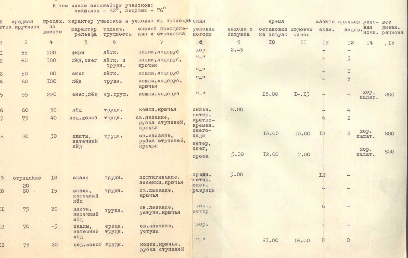 A platform on such negative inclinations is unsuitable (Ryabukhin - Trubnikova). To exit the group onto the top of the overhanging wall, a 10-meter and two 1.5-meter ladders were used. Fig. 14. Backpacks were also pulled up on this section. Fig. 15. Next is a 30-meter traverse to the right and upwards to the ice gully via indistinct ledges on 80° slabs (R10). Fig. 12. Backpacks were pulled up. Along the protruding slabs of the ice gully (R11), we ascend to the base of a smooth wall with two 2-meter detached slabs. Between this wall and the slabs is ice, in which it is convenient to cut out platforms for pulling up and receiving backpacks. With a 20-meter traverse to the right, we transition into a steep ice gully ascending vertically along the western part of the second wall. Up the ice gully, through two rock islands, we ascend to the top of the second rock island (R13). Fig. 16. Backpacks are pulled up. The group set up a sitting bivouac (4550 m) on three sites: Samokhvalov - on ice platforms for pulling up backpacks, Ryabukhin and Trubnikova - on top of the second rock island, Makovetsky - in a chimney next to the island. Fig. 17 and 18.
August 17. In the ice gully, there are two 4-meter ledges (R14). Fig. 16. From the upper ledge, we move left onto rocks. The first five meters are a negative inclination (7-10°) - passed using ladders. Then, dissected slabs - 8 m at 80° and 10 m at 90° - lead to a platform under a 3-meter wall.
On R14 and R15, backpacks were pulled up. Trubnikova first passed R14 and R15. Along a snow and ice slope, we move left and upwards, cross an ice gully, and via rocks, exit to the top of the second wall (R16 and R17). Fig. 20. Here, the second control cairn is built.
We prepare a platform for a tent (4700 m) 15 m higher on a snow and ice ridge (R18). Fig. 21.
Sections R16, R17, R18 were first passed by the Samokhvalov - Makovetsky rope team.
August 18. From the bivouac, directly upwards along the snow and ice ridge (R19) to the right part of the rock islands (R20).
Fig. 22. In the upper part of the island is a 3-meter wall closed by a 40-cm awning. Passed by free climbing. Along an ice slope to the right and upwards to the base of an ice gully with numerous embedded white stones ("white gully") - R21.
Sections:
- R19
- R20
- Fig. 22
- R21
The most complex sections include rock sections with a steepness of 80° and more, and ice sections with a steepness of 75° and more. See the appendix with a special opinion.
The coach and team captain, instructor, Master of Sports of the USSR A.G. Ryabukhin. R19, R20, R21 were first passed by Samokhvalov - Makovetsky. Along the "white gully" (R22, Fig. 23), we ascend to a transverse snow and ice ridge. The abundance of sharp protruding stones does not allow pulling up backpacks in the "white gully", which significantly complicates its passage. On the ridge, 50-70 cm of loose snow is almost not connected to the smooth natty ice. Steps have to be cut, raking away the snow (R23).
- A 15-meter sheer wall (R24, Fig. 24 and 25) is passed via an internal angle. Backpacks were pulled up.
- A snow and ice ridge (R25, Fig. 25) through a rock island leads to an ice gully with rock ledges (R26, Fig. 26).
- A plug in the upper part of the gully is bypassed from the outside by wedging into the walls of the gully. Backpacks are pulled up.
- On the third ice belt (R27, Fig. 25), under the base of the fourth wall (Fig. 27), we cut out a platform for a tent (5000 m).
August 19. From the bivouac, along a rantkluft under the base of the fourth wall, 10 m to the right, and then left and upwards to a platform convenient for pulling up backpacks (Fig. 27 and 28). A convex stone overhanging the platform is bypassed on the left via ice gullies, and we ascend to a slab with a characteristic white transverse stripe and an awning above it (Fig. 29). We exit to the top on the left part of the awning. Via an internal angle, we exit to the top of the tower (R28, Fig. 27). Further upwards along a faintly expressed snow and ice ridge (the character of the ridges is as on the III wall) and a 30-meter traverse to the left, we cross a steep ice couloir (R29) in the direction of the lower protruding stones. Along an ice slope with embedded stones (R30) directly upwards to a wall dissected by three vertical chimneys (R31). At the base of the chimneys, we traverse left to the beginning of the left chimney and ascend it. Above the wall is a snowy summit dome (R32). Loose deep snow (Fig. 30). A cairn is built on rocks protruding in the western part of the summit. The descent from the summit along the western snow ridge with a steepness of 45-55° to the saddle with Festivalnaya Peak took 2 hours. Bivouac on a plateau (4600 m). Fig. 32.
August 20. We descend on crampons from the plateau along the northern ice slope between Jigit Peak and Festivalnaya Peak, and then along a corniced ridge onto the Oyuntyor Glacier. Fig. 32. The descent took 7 hours (9 ice and 2 rock pitons were left on the descent).
 Fig. 14. Profile of the route to Jigit Peak via the North face on August 13-20, 1965. Team composition: Ryabukhin A.G. (captain), Trubnikova O.I., Samokhval