Passport
-
Technical class
-
Tian-Shan, Terskey Ala-Too, Karakol gorge
-
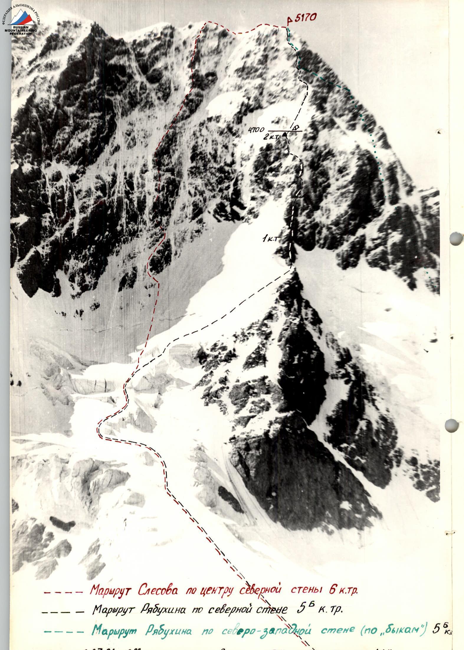
Peak Jigit 5170 m, via the north wall
-
Difficulty category — 5B
-
Route characteristics:
- height difference — 1230 m,
- route length — 1650 m,
- length of sections with 5–6 difficulty category — 1083 m,
- average steepness of the main part of the route — 67°.
-
Pitons hammered:
| rock | bolt | chocks | ice screws |
|---|---|---|---|
| 163 | 0 | 59 | 35 |
| 0 | 2 | 0 |
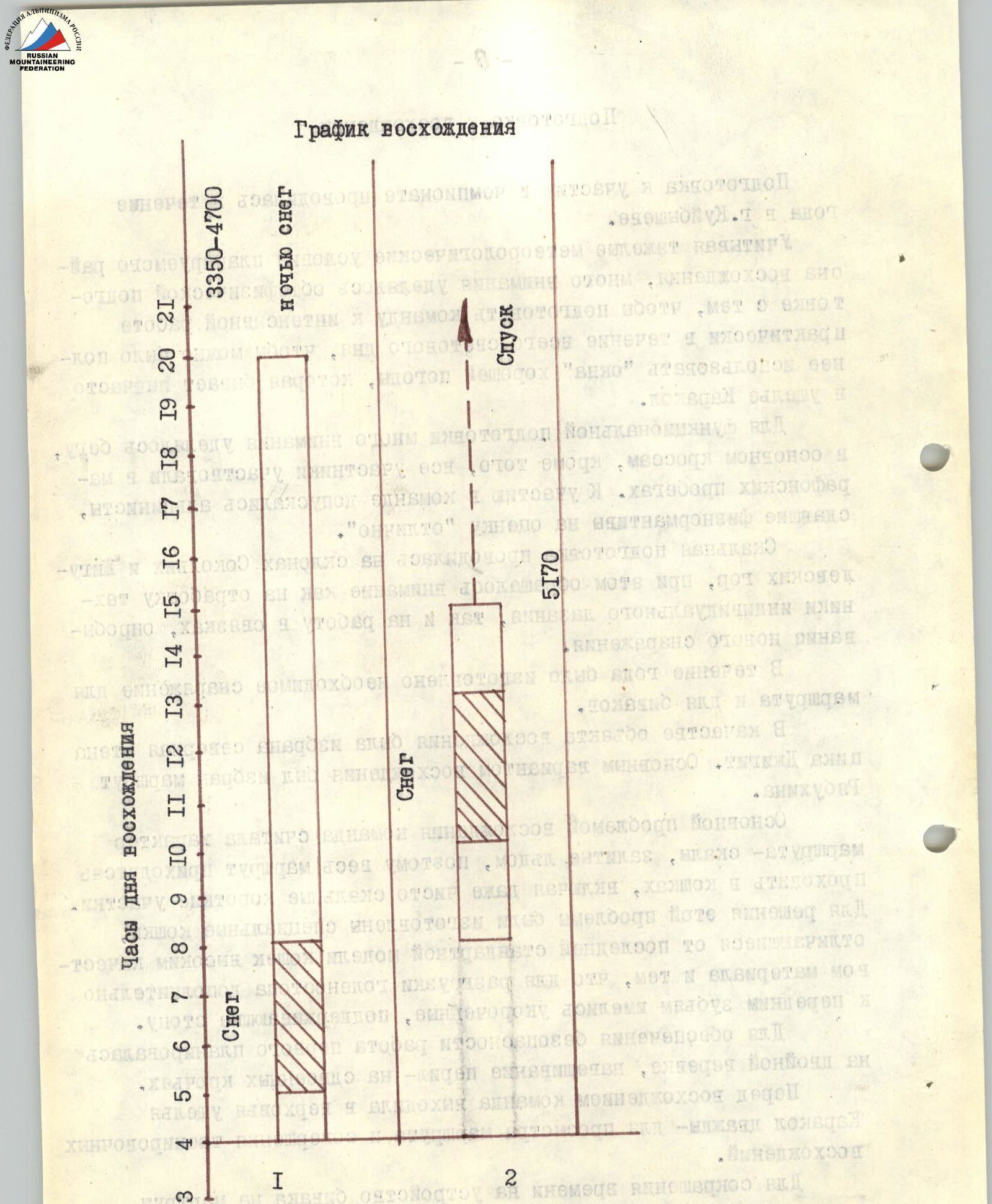
- Team's travel hours — 29, days — 2.
- Overnight stay — 1 on a snow-ice platform; lying down
- Team composition:
Team leader — Vesnin Vladimir Ivanovich CMS, Participants:
- Korneichuk Anatoly Ananievich 1st sports category
- Zhikharev Sergey Ivanovich 1st sports category
- Timergaziev Vasil Magnavievich 1st sports category
- Team coach — Krasnov Valentin Stepanovich, 2nd category instructor, CMS.
- Approach to the route — July 15, 1984,
Summit — July 16, 1984,
Return — July 16, 1984
Preparation for the ascent
Preparation for participation in the championship was carried out over the course of a year in Kuibyshev.
Taking into account the harsh meteorological conditions of the planned ascent area, a lot of attention was paid to general physical preparation, so that the team could prepare for intense work practically throughout the entire daylight hours, in order to make the most of the "windows" of good weather, which are not frequent in the Karakol gorge.
For functional training, a lot of attention was paid to running, mainly cross-country running, and all participants took part in marathon runs. Only climbers who passed the physical fitness standards with an "excellent" grade were allowed to join the team.
Rock climbing training was conducted on the slopes of Sokoliye and Zhiguli mountains, with attention paid to both individual climbing techniques and working in rope teams, testing new equipment.
Over the course of the year, the necessary equipment for the route and bivouacs was manufactured.
The north wall of Peak Jigit was chosen as the object of ascent. The main variant of the ascent was the Ryabukhin route.
The team considered the main problem of the ascent to be the nature of the route — rocks covered in ice, so the entire route had to be traversed in crampons, including even short purely rock sections (see photo 3). To solve this problem, special crampons were made, differing from the latest standard model by high-quality material and the presence of shortened, supporting foot teeth in addition to the front teeth.
To ensure safety, the first climber's work was planned on a double rope, and belay rope installation was done on paired pitons.
Before the ascent, the team went to the upper reaches of the Karakol gorge twice — to review the route and carry out training ascents.
To reduce the time spent on setting up a bivouac on the route, it was planned to bring a hammock, although the overnight stay was planned on a snow-ice slope. The hammock was used to expand the platform — it was hung and snow was dug into it.
Note:
- Day 1 — see photo 1
- Day 2 — see photo 2
Tactical actions of the team
The team's tactical actions were carried out without deviations from the tactical plan, which was drawn up based on the report of the first ascenders (Ryabukhin's team), as well as on the recommendations of Ryabukhin and V. F. Boshman.
In addition to mandatory technical norms, the part of the tactical plan aimed at ensuring accident-free passage of the route included:
- passing avalanche-prone sections in the morning,
- constant change of the lead climber,
- interaction between rope teams,
- using individual abilities of participants when passing a particular section of the route,
- constant communication with the observation group.
The equipment list included chocks of various sizes, titanium pitons, ice screws, "Jumar" type rope clamps, crampons of our own design, and other tested and well-proven equipment.
No preliminary processing of sections was carried out. Communication with the observation group was carried out using a "Stroyka" type VHF radio station; in addition, the observation group constantly conducted visual observation through a 25x telescope. To ensure safety during overnight stays, a rescue team from the Kuibyshev regional council of the Zenit sports society was present with the observers.
The first climber moved on a double rope, and belay ropes were installed on paired pitons.
During periods of deteriorating weather, the interval between participants was reduced to ensure voice and visual communication. The first climber was completely unloaded.
Throughout the entire route, there were no falls or injuries to participants.
The physical preparation of the participants made it possible to ensure movement on the route throughout the entire day. The passage of the route in two days was dictated by weather conditions, as well as the fact that on the route (except for the lower part) there are only two convenient places for overnight stays (near each other) for the team to rest properly.
Description of the route by sections
- On July 15 at 4:00, the team started the route from the camp on the left-bank lateral moraine of the Jigit glacier (observers' camp — 3550 m).
We cross to the right-upwards, dissected by radial crevasses, closed glacier, and approach the ascent to the cirque between the NE and N buttresses. We ascend to the ice falls (R2) via the tongue of the cirque glacier (R1). The first fall is bypassed on the right, then we traverse left and bypass the second fall. We cross crevasses behind the second fall using snow bridges. The third fall is bypassed on the left of the slot filled with snow. At the top of the fall, we cross three crevasses using delicate bridges. The fourth fall is bypassed on the left, and we move above it to the right-upwards through loose deep snow to the bergschrund (R3). The right edge of the cornice on the ridge serves as a landmark for exiting onto the ridge of the buttress. Above the bergschrund, there are 40 m of ice flow. The remaining section to the ridge is porridge-like ice.
On the ridge above the first wall, the first control cairn is built (end of R4). The ridge goes up in three rises of increasing steepness. The cornice between the first and second rises does not present a difficulty for passage.
At the beginning of the third rise (4330 m), there is a groove formed by slabs covered in ice, going to the right-upwards. After 20 m, the groove turns directly upwards. We ascend via the slabs to the base of the overhanging wall with a characteristic yellow horizontal stripe (R7–R8).
At the base of the overhanging wall, two smooth, overhanging walls converge, forming an internal corner with 20° negative inclination, closed from above by a 70–80 cm rock overhang (R9, photo 1). The wall was climbed using ladders — platforms on such negative inclinations are not suitable. The group emerged on top using étriers. In this place, it is better to organize the hauling of backpacks.
Next, there is a 30 m traverse to the right-upwards to an ice groove along poorly defined ledges on 80° slabs (R10). Backpacks were hauled.
Via protruding slabs of the ice groove (R11), we ascend to the base of a smooth wall with two 2-meter detached slabs. Between this wall and the slabs, there is ice in which it is convenient to carve out a platform for hauling and receiving backpacks.
20 m traverse to the right leads to a steep ice groove going vertically upwards along the western part of the second wall. Via the ice groove, through two rock "islands," we ascend to the top of the rock island (R13). Backpacks are hauled (4550 m). Further, in the ice groove, there are two 4-meter ice falls (R14). From the upper fall, we move left onto the rocks. The first 5 m — negative 7–10° inclination — are climbed using ladders. Then, 8 m — 80° and 10 m — 90° dissected slabs lead to a platform under the third wall. On R14–R15, backpacks are hauled.
Via a snow-ice slope to the left-upwards, we cross the ice groove and via rocks, we exit to the top of the second wall (R16–R17). Here, the second control cairn is built (4700 m). A platform for the tent is set up 15 m higher on a snow-ice ridge (R18).
From the overnight stay, directly upwards via a snow-ice slope (R19) to the right part of the rock "islands" (R20). In the upper part of the island, there is a 3-meter wall closed by a 40-cm overhang. It is climbed using free climbing. Via an ice slope to the right-upwards, to the base of an ice groove with numerous embedded white stones ("white groove", R21).
Via the "white groove" (R22), we ascend to a transverse snow-ice ridge. The abundance of sharp protruding stones does not allow hauling backpacks in the "white groove", which greatly complicates its passage on the ridge — 50–70 cm. Loose snow is almost not connected to the smooth ice flow. Steps have to be carved out, clearing the snow (R23).
A 15-meter sheer wall (R24) is climbed via an internal corner. Backpacks are hauled.
A snow-ice ridge (R25) through a rock island leads to an ice groove with rock falls (R26). A "plug" in the upper part of the groove is bypassed from the outside by wedging into the walls of the groove. Backpacks are hauled.
On the third ice belt (R27), under the base of the fourth wall, 10 m to the right, and then left-upwards to a platform suitable for hauling backpacks. A convex stone overhanging the platform is bypassed on the left under the ice groove, and we ascend to a slab with a characteristic white horizontal stripe and an overhanging cornice above it. We exit to the top in the left part of the cornice.
Via an internal corner, we exit to the top of the tower. Further, via a poorly defined snow-ice ridge (the nature of the ridges is like on the third wall) and 30 m traverse to the left, we cross a steep ice couloir (R29) in the direction of the lower protruding stones.
Via an ice slope with embedded stones (R30), directly upwards via a wall dissected by three vertical chimneys (R31). At the base of the chimneys, a traverse to the left to the beginning of the left chimney, and up it. Above the wall, there is a snowy summit dome. Loose deep snow. A cairn is built on rocks protruding in the western part of the summit (see photo 2).
Descent from the summit is via the western snow-ice ridge to a saddle with V. Festivalnaya, then to the right-downwards via a snow-ice slope to rocks, and via them, descent to the Ayuntur glacier.