PASSPORT
- Technical category
- Tian-Shan, Terskey Ala-Too ridge
- Peak "Dzhigit", via the north face — 5B category
- Route by A.G. Ryabukhin, climbed in 1965
- Height difference: 998 m, length — 1177 m.
Length of sections with 5 category difficulty — 397 m. Average steepness of sections — 60°
- Pitons driven:
| Rock | Nuts | Ice |
|---|---|---|
| 110 | 40 | 20 |
| 5 | 0 | 0 |
-
Team's total climbing hours: 36 hours and days — 4
-
Overnights: 1st platform, cut out on a snow-ice ridge; 2nd platform, cut out on a snow-ice ridge; 3rd platform on the saddle between Peak Dzhigit and Peak Festivalnaya.
-
Team leader: Rassolov Oleg Vasilievich CMS
Team members:
- Kuznetsov Andrey Viktorovich CMS
- Noskov Anatoly Alekseevich CMS
- Altshuler Leonid Borisovich CMS
-
Coach: Chernov Lionel Alexandrovich MS
-
Approach to the route: July 28, 1983
Summit — July 30, 1983. Descent — July 31, 1983
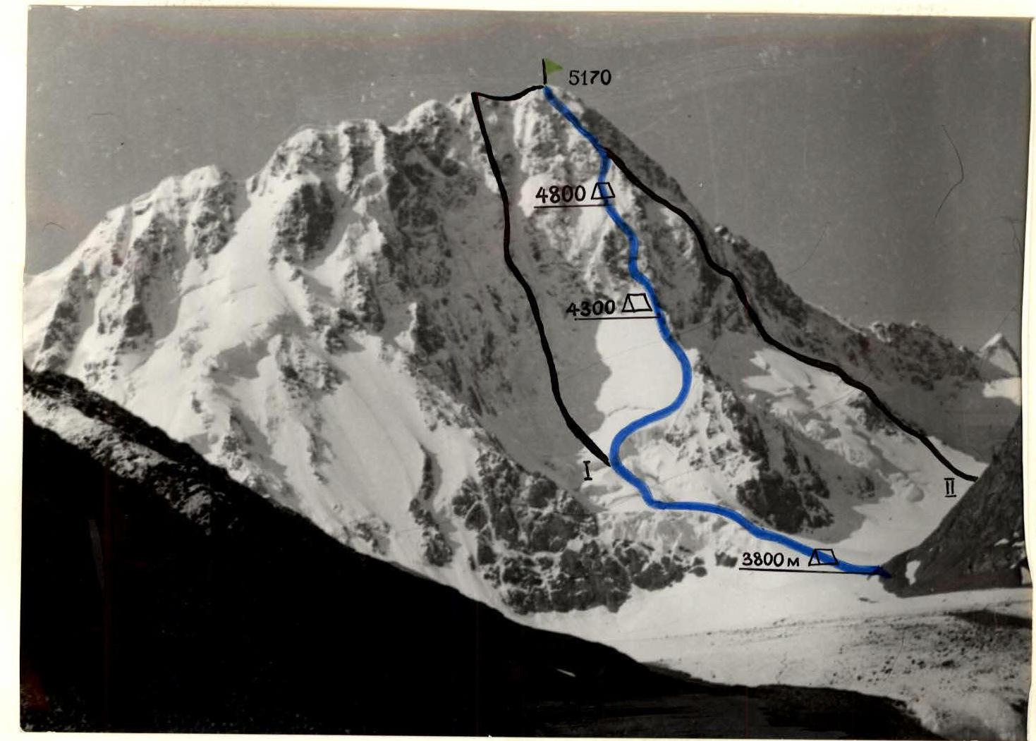
I — center of the north face, Slesov's route. II — via the northwest face, Ryabukhin's route.
Taken on July 24, 1983 at 10:00, camera "Lyubitel". Distance to the shooting point 5–6 km, point No. 1, shooting height 3700 m.
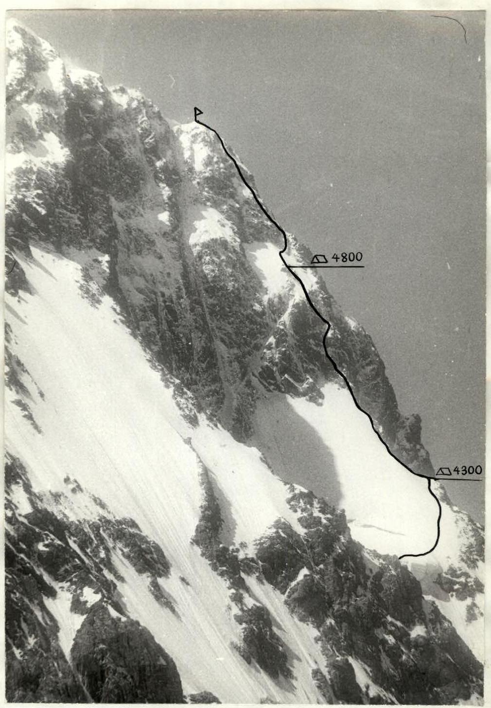
Profile of the face on the left. Shooting time: July 28, 1983, 14:00. Distance to the object — 1.5–2 km (approximately). Shooting location — Dzhigit glacier, point 2. Height of the shooting point — 3900 m.
Team's Tactical Actions
The delay in departing for the route and completing the ascent by one day was due to resolving financial issues with the "Ala-Too" tourist camp.
On July 27, 1983, the entire team and observers spent the night near the Kok-Bor pass. On this day, they observed the state of the route. A protocol was drawn up for preliminary observation of the route's condition (see "Supplement", "Protocol").
On July 28, 1983, at 5:30, the team started the route. At 10:00, the group approached the 2nd wall (section R2–R13). The duo Kuznetsov–Noskov, after a hour-long rest, began processing the wall, while Rassolov–Altshuler organized an overnight stay.
According to the available description, Kuznetsov–Noskov (Kuznetsov leading) attempted to ascend the route to the right and upwards, but after climbing two ropes, it became clear that this path was not feasible due to the impossibility of organizing reliable belays because of the severe ice coverage on the rocks. One rope was removed, and Noskov began processing the route to the left and upwards. At 18:00, the last two ropes were hung, and at 19:00, the duo descended for the night. Thus, on the first day, 120 m of rope were fixed on sections R2–R7.
On July 29, 1983, at 9:30, the group departed from the overnight location in the following order: Rassolov–Kuznetsov, Altshuler–Noskov. Climbing the fixed ropes took 2.5 hours.
Sections:
- R7–R11, R12–R13 — Rassolov leading, climbed with piton protection and rope fixing.
- R11–R12 — climbed independently by each rope team with alternating belays.
- R13–R14 — climbed independently by each rope team with alternating belays.
- R14–R15 — Kuznetsov leading, climbed with piton protection and rope fixing.
According to the tactical plan, the overnight stay was to be organized at section R13, but due to the early arrival at this section (14:30), it was decided to continue the ascent. At 17:00, the group gathered at the overnight location. Two hours later, a platform was cut out, and a tent was set up.
On July 30, 1983, the group departed from the overnight location at 9:00 in the following order: Kuznetsov–Rassolov, Altshuler–Noskov.
Section R15–R16 — climbed simultaneously. Section R16–R17 — Kuznetsov leading, with piton protection and rope fixing. Sections R17–R25 — Rassolov leading, on sections R17–R24 — rope fixing.
At 16:30, the duo Rassolov–Kuznetsov reached the summit. At 17:30, the group gathered on the summit in full. Descent was made along the western ridge via the route of 4A category difficulty to the saddle between Peak Dzhigit and Peak Festivalnaya. Overnight stay.
On July 31, 1983, descent was made from the saddle to the Karakolsky glacier and further to the "Ala-Too" tourist camp.
The sections R2–R13, R14–R15, R17–R18, R19–R21, R23–R25 were climbed by the lead climber on a double rope.
The following equipment was used on the sections:
- R10–R11 and R23–R24: ITO
- R2–R13, R14–R17, R24–R25: crampons
Communication with observers was regular, as reflected in the "Observation Diary" (see "Supplement").
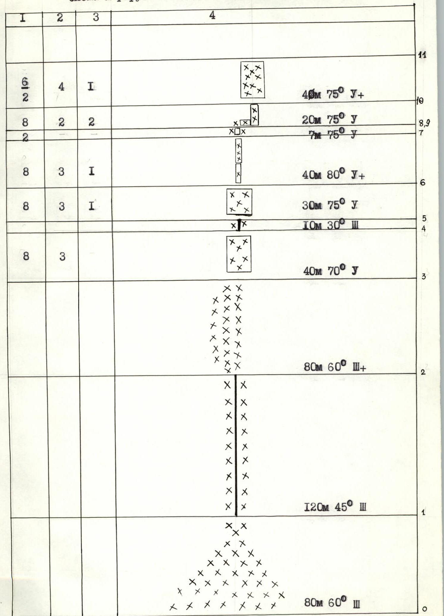
Route diagram in UIAA symbols. Scale 1:2000
| Total | Own | Fixed | Sections |
|---|---|---|---|
| 8 (p.6) | 3 (p.6) | 40 m 60° 1 | |
| 20 m 40° 2 | |||
| 8 (p.6) | 3 (p.6) | 1 (p.6) | |
| 1 (p.7) | 2 (p.7) | 3 (p.7) | 50 m 70° 1 |
| 2 (p.7) | 40 m 50° 2 | ||
| 8 (p.7) | 3 (p.7) | 1 (p.7) | 80 m 50° 2 |
| 2 (p.7) | 1 (p.7) | 3 (p.7) | 40 m 60° 1 |
| 8 (p.7) | 3 (p.7) | 1 (p.7) | 80 m 50° 2 |
| 8 (p.7) | 3 (p.7) | 1 (p.7) | 40 m 60° 1 |
| 40 m 65° 2 | |||
| 80 m 45° 2 |
Pitons driven — 170 pieces. Total climbing hours — 30 hours 30 minutes.
| Rock | Nuts | Ice | Sections |
|---|---|---|---|
| 8 (p.6) | 3 (p.6) | 40 m 75° 1+ | |
| 20 m 75° 1 | |||
| 7 m 75° 1 | |||
| 8 (p.6) | 3 (p.6) | 1 (p.6) | 40 m 80° 1+ |
| 8 (p.6) | 3 (p.6) | 1 (p.6) | 30 m 75° 1 |
| 10 m 30° 3 | |||
| 8 (p.6) | 3 (p.6) | 40 m 70° 1 | |
| 80 m 60° 3+ | |||
| 120 m 45° 3 | |||
| 80 m 60° 3 | |||
| 3 (p.8) | 2 (p.8) | 4 (p.8) | 80 m 50° 4 |
| 8 (p.8) | 3 (p.8) | 4 (p.8) | 40 m 70° 1 + 20 m 70° 1 |
| 8 (p.8) | 20 m 60° 2 | ||
| 8 (p.8) | 3 (p.8) | 20 m 60° 2, 20 m 60° 1 |
Route Description by Sections
Section R0–R1. Snow-ice slope. Section R1–R2. Snow-ice ridge. Overnight location. Section R2–R3. Snow-ice slope. Control point. Section R3–R4. Rocks covered in ice. Section R4–R5. Snow-ice ridge. Section R5–R6. Up the face to the left (rocks covered in ice). Section R6–R7. Slabs covered in ice. Section R7–R8. Up under the overhang (slabs covered in ice). Section R8–R9. Traverse to the right and upwards (rocks covered in ice). Section R9–R10. Up the face covered in ice. Section R10–R11. Up the face covered in ice. Section R11–R12. Snow-ice slope turning into a snow ridge.
Section R12–R13. Rocky ridge covered in ice.
Section R13–R14. Snow-ice ridge turning into a snow-ice slope. Top of the second rocky wall.
Control point.
Section R14–R15. Rocky-ice gully leading to the top of the rocky outcrop.
Overnight location.
Section R15–R16. Snow-ice ridge.
Section R16–R17. Traverse to the right and upwards on a snow-ice slope.
Section R17–R18. Up the gully with "white" stones. Rocks covered in ice.
Section R18–R19. Snow-ice slope.
Section R19–R20. Rocks.
Section R20–R21. Up the face. Rocks covered in ice.
Section R21–R22. Rocks of moderate difficulty.
Section R22–R23. Snow-ice ridge.
Section R23–R24. Rocks.
Section R24–R25. Ice slope with rock outcrops and frozen stones.
Section R25–R26. Snow-ice slope of the summit dome. Summit. Control point.
Descent along the western ridge — route of 4A category difficulty.